ATL : INVEST 94L
Moderator: S2k Moderators
- cycloneye
- Admin

- Posts: 139184
- Age: 67
- Joined: Thu Oct 10, 2002 10:54 am
- Location: San Juan, Puerto Rico
Re: ATL : INVEST 94L
HPC Caribbean discussion:
http://www.hpc.ncep.noaa.gov/discussions/fxca20.html
AT LOW LEVELS...THE OBJECTIVE ANALYSIS SHOWS AN ELONGATED FRONT
STRETCHING ACROSS CAT ISLAND IN THE BAHAMAS-CENTRAL/WESTERN CUBA
TO NORTHERN YUCATAN PENINSULA. THE FRONT WILL REMAIN NEARLY
STATIONARY WHILE WEAKENING OVER THE BAHAMAS-CUBA-YUCATAN PENINSULA
THROUGH 36 HRS. THERE IS ALSO A FRONTAL SHEAR LINE/CONFLUENT
ASYMPTOTE THAT WILL EXTEND ACROSS PUERTO RICO TO NORTHEAST
HONDURAS THROUGH 24-36 HRS...TO ALSO WEAKEN THROUGH 48-54 HRS AS
IT PULLS OVER THE NORTHERN LEEWARD ISLANDS. UNDER INFLUENCE OF THE
DEEP POLAR TROUGH PATTERN OVER THE WESTERN ATLANTIC...AN
INDUCED/INVERTED TROUGH AMPLIFIES ACROSS THE CENTRAL CARIBBEAN
ALONG 82W/83W TO THE CAYMAN ISLANDS. THE TROUGH MOVES TO EASTERN
NICARAGUA BY 18-24 HRS...TO CENTRAL HONDURAS-BELIZE/QUINTANA ROO
MEXICO BY 48 HRS. THIS TROUGH...IN INTERACTION WITH THE
ITCZ...WILL SUSTAIN THE GRADUAL INTENSIFICATION OF AN 850 HPA LOW
OVER THE SOUTHERN CARIBBEAN. SATELLITE IMAGES ALREADY SHOW
CONVECTION DEVELOPING AROUND A LOW LEVEL CYCLONE TO THE EAST OF
NICARAGUA/NORTH OF COSTA RICA. THE TPC IS MONITORING THIS FEATURE
FOR RISK OF TROPICAL CYCLONE FORMATION.
0 likes
Visit the Caribbean-Central America Weather Thread where you can find at first post web cams,radars
and observations from Caribbean basin members Click Here
and observations from Caribbean basin members Click Here
-
jlauderdal
- S2K Supporter

- Posts: 6774
- Joined: Wed May 19, 2004 5:46 am
- Location: NE Fort Lauderdale
- Contact:
Re: ATL : INVEST 94L
cycloneye wrote:wxman57 wrote:cycloneye wrote:There is a 94L models thread.
Never understood the need for 2 separate discussion threads. This is where we're discussing the potential future of the disturbance. Are we supposed to post the model images there then talk about them here?
We haved done separated threads since storm2k came to life called the main thread for members to discuss all about the system and the models thread to post the runs from the different models.We do it this way for the Atlantic systems as information about the models gets lost when a main thread gets many replies.When a models thread is up,is more easy for the members to find the model runs in one place rather than in a mix of other discussions.I can ask the admins to look into it to see if we can forget about model threads.
check it out and discuss with admins, also putting the pacific systems in a completely different area would really make site navigation easier, i can only imagine the difference in visitors to atlantic vs pacific
BTW, ortts model of choice is GFS( Good For S**T)
0 likes
- wxman57
- Moderator-Pro Met

- Posts: 22482
- Age: 66
- Joined: Sat Jun 21, 2003 8:06 pm
- Location: Houston, TX (southwest)
Re: ATL : INVEST 94L
Here's a current surface plot with satellite overlay. Any weak rotation/vorticity is very near the coast of Nicaragua now. Interesting that we haven't had any new model guidance come out after the 12Z runs. It probably was a bit early to declare an invest, as there's not much development chance for another 3-4 days.


0 likes
-
Derek Ortt
- cycloneye
- Admin

- Posts: 139184
- Age: 67
- Joined: Thu Oct 10, 2002 10:54 am
- Location: San Juan, Puerto Rico
Re: ATL : INVEST 94L
18z surface analysis adds another low in NW Caribbean.The SW Caribbean low remains offshore.

http://www.nhc.noaa.gov/tafb_latest/CAR_latest.gif

http://www.nhc.noaa.gov/tafb_latest/CAR_latest.gif
0 likes
Visit the Caribbean-Central America Weather Thread where you can find at first post web cams,radars
and observations from Caribbean basin members Click Here
and observations from Caribbean basin members Click Here
Re: ATL : INVEST 94L
cycloneye wrote:There is a 94L models thread.
Why not just post model data in the models thread and have all the discussion in this forum.
So there is no duplication yet easy access to the models without scrolling through page after page when the board gets active
Just my $.02
0 likes
- cycloneye
- Admin

- Posts: 139184
- Age: 67
- Joined: Thu Oct 10, 2002 10:54 am
- Location: San Juan, Puerto Rico
Re: ATL : INVEST 94L - Models
18z GFS at 120 hours develops it.


0 likes
Visit the Caribbean-Central America Weather Thread where you can find at first post web cams,radars
and observations from Caribbean basin members Click Here
and observations from Caribbean basin members Click Here
- Ivanhater
- Storm2k Moderator

- Posts: 10852
- Age: 37
- Joined: Fri Jul 01, 2005 8:25 am
- Location: Pensacola
Re: ATL : INVEST 94L - Models
174 hours...seems to deepen. has moved nw but slowly. I'd bet this run sits it there before the front sweeps it away


0 likes
Michael
- cycloneye
- Admin

- Posts: 139184
- Age: 67
- Joined: Thu Oct 10, 2002 10:54 am
- Location: San Juan, Puerto Rico
Re: ATL : INVEST 94L
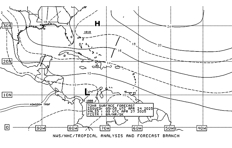
This is the 72 hour forecast from TAFB and it still has the low in the SW Caribbean on Friday.

http://www.nhc.noaa.gov/tafb_latest/atl ... testBW.gif

http://www.nhc.noaa.gov/tafb_latest/atl ... testBW.gif
0 likes
Visit the Caribbean-Central America Weather Thread where you can find at first post web cams,radars
and observations from Caribbean basin members Click Here
and observations from Caribbean basin members Click Here
-
lonelymike
- S2K Supporter

- Posts: 634
- Joined: Sat Jul 26, 2008 10:12 am
- Location: walton county fla
Re:
gatorcane wrote:18Z GFS goes crazy with this thing now, major cane in the GOM (albeit way out at 324 hours).
Ivanhater, check it out:
For entertainment purposes only. After all it is the GFS model
Last edited by lonelymike on Tue Oct 20, 2009 5:59 pm, edited 1 time in total.
0 likes
GO SEMINOLES
- cycloneye
- Admin

- Posts: 139184
- Age: 67
- Joined: Thu Oct 10, 2002 10:54 am
- Location: San Juan, Puerto Rico
Re: ATL : INVEST 94L - Models
0 likes
Visit the Caribbean-Central America Weather Thread where you can find at first post web cams,radars
and observations from Caribbean basin members Click Here
and observations from Caribbean basin members Click Here
Who is online
Users browsing this forum: No registered users and 20 guests


