ATL: TROPICAL DEPRESSION DANNY (05L)

Moderator: S2k Moderators

Message
Author
tolakram
Admin
Admin
Posts: 20010
Age: 62
Joined: Sun Aug 27, 2006 8:23 pm
Location: Florence, KY (name is Mark)

Re: ATL: Invest 92L

#881 Postby tolakram » Wed Aug 26, 2009 6:33 am

http://www.ssd.noaa.gov/goes/flt/t1/flash-ir2.html


Image


Why can't they bring back the old shortwave format? Is this really better? /complain
0 likes   

User avatar
storms NC
Tropical Storm
Tropical Storm
Posts: 247
Age: 69
Joined: Tue Sep 14, 2004 2:41 pm
Location: Coast of NC & southwest coast of Fla

Re: ATL: Invest 92L

#882 Postby storms NC » Wed Aug 26, 2009 6:33 am

HURAKAN wrote:TROPICAL WEATHER DISCUSSION
NWS TPC/NATIONAL HURRICANE CENTER MIAMI FL
805 AM EDT WED AUG 26 2009

...SPECIAL FEATURES...
A SURFACE TROUGH IS ALONG 27N67W 24N69W 21N69W...MOVING
WESTWARD ABOUT 15 KT. GALE FORCE WINDS ARE WITHIN 150 NM OF
24N69W IN THE NORTHEASTERN SEMICIRCLE. THE DATA FROM THE AIR
FORCE RESERVE RECONNAISSANCE PLANE THAT FLEW THROUGH THIS AREA
DURING THE TIMES FROM 25/1900 UTC UNTIL 25/2100 UTC DID NOT
SHOW A CLOSED CYCLONIC CIRCULATION AT THE SURFACE, BUT THE
27N67W 21N69W SURFACE TROUGH. A MIDDLE LEVEL TO UPPER
LEVEL TROUGH ALSO JUST HAPPENS TO BE IN THE SAME NEIGHBORHOOD
AS THE SURFACE TROUGH AND THE AREA OF GALE-FORCE WINDS.
SCATTERED STRONG SHOWERS AND THUNDERSTORMS COVER THE ATLANTIC
OCEAN FROM 23N TO 26N BETWEEN 64W AND 69W. SHOWERS ALSO COVER
THE REST OF THE AREA FROM HAITI TO 32N BETWEEN 63W AND 75W.
IT IS POSSIBLE THAT A TROPICAL CYCLONE MAY FORM IN THIS AREA
DURING THE NEXT 48 HOURS.


The recon is just getting there.
0 likes   

User avatar
tailgater
S2K Supporter
S2K Supporter
Posts: 3339
Joined: Sun Jul 11, 2004 9:13 pm
Location: St. Amant La.

Re: ATL: Invest 92L

#883 Postby tailgater » Wed Aug 26, 2009 6:33 am

ON the Water Vapor Loop it still looks like a UUL is Just South of the Area yall are talking about and some dry air diving southward so I woukdn't think this is going to develop(intensify) very quickly.
http://www.ssd.noaa.gov/goes/flt/t1/loop-wv.html
0 likes   

User avatar
KWT
Category 5
Category 5
Posts: 31415
Joined: Tue Aug 17, 2004 11:02 am
Location: UK!!!

#884 Postby KWT » Wed Aug 26, 2009 6:38 am

It does indeed look like the center is heading due west which would mess up quite a few of the model projections, of course we need to wait till recon gets a proper fix on the system.
0 likes   

User avatar
HURAKAN
Professional-Met
Professional-Met
Posts: 46086
Age: 38
Joined: Thu May 20, 2004 4:34 pm
Location: Key West, FL
Contact:

#885 Postby HURAKAN » Wed Aug 26, 2009 6:38 am

Do a loop and you will clearly see what appears to be a LLC

http://wwwghcc.msfc.nasa.gov/GOES/goeseastconus.html
0 likes   

User avatar
HURAKAN
Professional-Met
Professional-Met
Posts: 46086
Age: 38
Joined: Thu May 20, 2004 4:34 pm
Location: Key West, FL
Contact:

#886 Postby HURAKAN » Wed Aug 26, 2009 6:38 am

087
ABNT20 KNHC 261138
TWOAT
TROPICAL WEATHER OUTLOOK
NWS TPC/NATIONAL HURRICANE CENTER MIAMI FL
800 AM EDT WED AUG 26 2009

FOR THE NORTH ATLANTIC...CARIBBEAN SEA AND THE GULF OF MEXICO...

SATELLITE IMAGERY INDICATES THAT THE AREA OF DISTURBED WEATHER
CENTERED ABOUT 470 MILES EAST OF NASSAU IN THE BAHAMAS IS
DEVELOPING A WELL-DEFINED CIRCULATION. THE SYSTEM COULD DEVELOP
INTO A TROPICAL DEPRESSION...OR MORE LIKELY A TROPICAL STORM...AT
ANY TIME AS IT MOVES WEST-NORTHWESTWARD AT ABOUT 15 MPH...AND IF
CURRENT TRENDS CONTINUE ADVISORIES WILL BE INITIATED LATER TODAY.
THERE IS A HIGH CHANCE...GREATER THAN 50 PERCENT...OF TROPICAL
CYCLONE FORMATION DURING THE NEXT 48 HOURS. INTERESTS IN THE
BAHAMAS SHOULD MONITOR THE PROGRESS OF THIS SYSTEM. A NOAA
HURRICANE HUNTER AIRCRAFT IS CURRENTLY ENROUTE TO INVESTIGATE THIS
SYSTEM.

ADDITIONAL INFORMATION ON MARINE WARNINGS ASSOCIATED WITH THIS
SYSTEM CAN BE FOUND IN HIGH SEAS FORECASTS ISSUED BY THE NATIONAL
WEATHER SERVICE...UNDER AWIPS HEADER NFDHSFAT1 AND WMO HEADER
FZNT01 KWBC.

ELSEWHERE...TROPICAL CYCLONE FORMATION IS NOT EXPECTED DURING THE
NEXT 48 HOURS.

$$
FORECASTER BEVEN
0 likes   

User avatar
HURAKAN
Professional-Met
Professional-Met
Posts: 46086
Age: 38
Joined: Thu May 20, 2004 4:34 pm
Location: Key West, FL
Contact:

#887 Postby HURAKAN » Wed Aug 26, 2009 6:40 am

URNT15 KWBC 261127
NOAA3 WXWXA AL92 HDOB 20 20090826
111730 2230N 06829W 6435 03857 0108 +051 +016 211020 020 999 999 03
111800 2230N 06827W 6434 03858 0110 +051 +016 213020 020 999 999 03
111830 2230N 06824W 6435 03858 0109 +051 +017 213021 022 005 000 03
111900 2230N 06822W 6435 03858 0108 +051 +018 211021 022 999 999 03
111930 2230N 06819W 6435 03858 0105 +053 +020 210019 020 006 000 03
112000 2230N 06817W 6434 03859 0102 +056 +017 209018 018 005 000 00
112030 2230N 06814W 6434 03860 0103 +055 +016 214017 017 005 000 03
112100 2230N 06812W 6434 03858 0101 +056 +016 215017 017 005 000 00
112130 2230N 06809W 6434 03859 0101 +057 +016 215018 018 006 000 03
112200 2230N 06807W 6435 03858 0101 +057 +016 213018 018 005 000 03
112230 2230N 06804W 6435 03859 0102 +057 +015 213018 018 005 000 03
112300 2230N 06802W 6435 03858 0099 +059 +013 212018 018 003 000 03
112330 2230N 06800W 6435 03859 0097 +060 +013 214018 018 005 000 03
112400 2230N 06757W 6436 03857 0097 +060 +012 219020 020 004 000 03
112430 2230N 06755W 6435 03859 0100 +059 +009 217021 022 005 000 00
112500 2230N 06752W 6436 03858 0101 +058 +004 214022 022 005 000 03
112530 2230N 06750W 6436 03857 0101 +057 +017 216021 021 004 000 03
112600 2230N 06747W 6435 03859 0099 +060 +005 216021 021 007 000 03
112630 2230N 06745W 6436 03858 0101 +059 +003 214021 021 005 000 03
112700 2230N 06742W 6436 03859 0107 +055 +005 217021 022 004 000 03
0 likes   

User avatar
HURAKAN
Professional-Met
Professional-Met
Posts: 46086
Age: 38
Joined: Thu May 20, 2004 4:34 pm
Location: Key West, FL
Contact:

Re: ATL : Invest 92L - Recon Thread

#888 Postby HURAKAN » Wed Aug 26, 2009 6:40 am

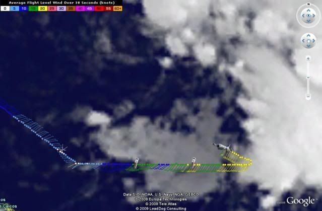
sevenleft wrote:Does anyone know if this mission will investigate the lower levels?


The NOAA missions usually doesn't investigate the low levels.
0 likes   

User avatar
KWT
Category 5
Category 5
Posts: 31415
Joined: Tue Aug 17, 2004 11:02 am
Location: UK!!!

#889 Postby KWT » Wed Aug 26, 2009 6:40 am

Yep looks like this will be started today but note they haven;t mentioned yet as quite what though.

By the way I think given the profile recon went through an eddy about 20 mins ago, will be interesting to see what profiles we get from the main LLC feature.
0 likes   

User avatar
gatorcane
S2K Supporter
S2K Supporter
Posts: 23691
Age: 47
Joined: Sun Mar 13, 2005 3:54 pm
Location: Boca Raton, FL

#890 Postby gatorcane » Wed Aug 26, 2009 6:42 am

it should start turing NW soon right? Seems to keeps racing pretty WNW to W.....perhaps once it starts to develop further it will start to gradually turn.

All of the models (GFS and its slaves) keep wanting to quickly move it NW run after run the past couple of days...
0 likes   

Aric Dunn
Category 5
Category 5
Posts: 21238
Age: 42
Joined: Sun Sep 19, 2004 9:58 pm
Location: Ready for the Chase.
Contact:

Re:

#891 Postby Aric Dunn » Wed Aug 26, 2009 6:45 am

gatorcane wrote:it should start turing NW soon right? Seems to keeps racing pretty WNW to W.....perhaps once it starts to develop further it will start to gradually turn.

All of the models (GFS and its slaves) keep wanting to quickly move it NW run after run the past couple of days...

that ridge as me a few others have been saying is holding quite strong.. the euro and cmc both have a west turn in there forecast in 36 hours..

but initially they were moving wnw .. it will change things for sure now that its been heading west the whole time and is already past 70w and most models barely bring it to 75 west..
a florida landfall still a decent possibility..
0 likes   

User avatar
Recurve
Category 5
Category 5
Posts: 1640
Joined: Tue Aug 16, 2005 8:59 pm
Location: St. Petersburg, FL

Re: ATL: Invest 92L

#892 Postby Recurve » Wed Aug 26, 2009 6:45 am

GenuineIndianGuru wrote:First off, hello; I've been follwing Bill through your great community all last week.
Being from Cape Breton Island, I was a bit on edge. Ofcoarse, and thankfully so, Bill just missed us.
I'm still very wet behind the ears as far as tracking from a technical stand point.
Now, I have a two part question.

How accurate are HWRF,BAMD,TVCN, and AVNO in their field of purpose? (Yep I'm thinking Danny may heading my way!)
Which method has more often the best track record? (no pun intended)


Since no one else answered, I'll try: Some models have skill, some are just statistical/climate models. AVN is usually ignored for tropical tracking. The BAMs apply to different strength storms (deep, shallow, and medium). Some models are a blend of other models.
You can read about the models here: http://www.nhc.noaa.gov/modelsummary.shtml

The best track record is probably no model at all, but the National Hurricane Center's official forecasts.

The posts in this forum are NOT official forecast and should not be used as such. They are just the opinion of the poster and may or may not be backed by sound meteorological data. They are NOT endorsed by any professional institution or storm2k.org. For official information, please refer to the NHC and NWS products.
0 likes   

User avatar
HURAKAN
Professional-Met
Professional-Met
Posts: 46086
Age: 38
Joined: Thu May 20, 2004 4:34 pm
Location: Key West, FL
Contact:

#893 Postby HURAKAN » Wed Aug 26, 2009 6:45 am

Image

Danny seems to be minutes or hours away.
0 likes   

User avatar
KWT
Category 5
Category 5
Posts: 31415
Joined: Tue Aug 17, 2004 11:02 am
Location: UK!!!

Re: Re:

#894 Postby KWT » Wed Aug 26, 2009 6:54 am

Aric Dunn wrote:that ridge as me a few others have been saying is holding quite strong.. the euro and cmc both have a west turn in there forecast in 36 hours..

but initially they were moving wnw .. it will change things for sure now that its been heading west the whole time and is already past 70w and most models barely bring it to 75 west..
a florida landfall still a decent possibility..


Yeah the models do seem to be a bit too northerly in the intial motion. I think this won't be that far from Florida but I do expect it will turn and be a bigger risk to the outer banks and possibly even N.Carolina in general if it gets far enough west over the next 36hrs or so.

Hurakan, yep likely to be a lop-sided Danny.
0 likes   

User avatar
cycloneye
Admin
Admin
Posts: 145355
Age: 68
Joined: Thu Oct 10, 2002 10:54 am
Location: San Juan, Puerto Rico

Re: ATL : Invest 92L - Recon Thread

#895 Postby cycloneye » Wed Aug 26, 2009 6:54 am

The next Air Force mission to the lower levels will depart at 10:00 AM EDT.

FLIGHT ONE - TEAL 72
A. 26/1800Z
B. AFXXX 0304A CYCLONE
C. 26/1400Z
D. 25.7N 70.5W
E. 26/1600Z TO 26/2030Z
F. SFC TO 10,000 FT
0 likes   

User avatar
HURAKAN
Professional-Met
Professional-Met
Posts: 46086
Age: 38
Joined: Thu May 20, 2004 4:34 pm
Location: Key West, FL
Contact:

#896 Postby HURAKAN » Wed Aug 26, 2009 6:55 am

000
URNT15 KWBC 261137
NOAA3 WXWXA AL92 HDOB 21 20090826
112730 2230N 06740W 6436 03858 0106 +055 +008 217023 023 999 999 03
112800 2230N 06738W 6436 03859 0107 +055 +004 215023 023 005 000 03
112830 2230N 06735W 6435 03860 0108 +054 +006 212023 023 004 000 03
112900 2230N 06733W 6437 03858 0108 +056 +002 214023 023 999 999 03
112930 2230N 06730W 6437 03858 0101 +060 -004 216022 024 999 999 03
113000 2231N 06728W 6435 03859 0100 +060 +003 214023 024 999 999 03
113030 2234N 06728W 6438 03858 0103 +058 +009 212023 024 999 999 03
113100 2235N 06730W 6437 03857 0096 +061 +006 212023 024 005 000 03
113130 2235N 06732W 6438 03854 0100 +058 +013 207022 022 007 000 03
113200 2236N 06734W 6437 03857 0104 +057 +007 204022 023 004 000 03
113230 2237N 06737W 6436 03858 0106 +055 +006 206022 022 005 000 03
113300 2237N 06739W 6435 03858 0105 +054 +015 208023 023 005 000 03
113330 2239N 06741W 6435 03859 0102 +058 +014 208022 023 006 000 03
113400 2240N 06743W 6433 03863 0105 +056 +013 208022 022 999 999 03
113430 2241N 06745W 6436 03861 0098 +061 +017 209021 021 005 000 03
113500 2242N 06747W 6436 03860 0098 +061 +016 207021 023 005 000 03
113530 2243N 06749W 6435 03860 0102 +058 +018 206021 021 006 000 03
113600 2244N 06751W 6435 03859 0101 +057 +020 203021 022 005 000 03
113630 2246N 06753W 6435 03859 0099 +058 +019 207020 021 005 000 03
113700 2247N 06755W 6435 03858 0097 +059 +015 206019 019 002 000 03

URNT15 KWBC 261147
NOAA3 WXWXA AL92 HDOB 22 20090826
113730 2249N 06757W 6435 03858 0097 +059 +017 203018 019 006 000 03
113800 2250N 06759W 6437 03855 0097 +059 +017 204019 020 005 000 03
113830 2251N 06801W 6437 03853 0101 +056 +018 205020 021 999 999 03
113900 2253N 06803W 6437 03854 0100 +057 +016 209018 019 006 000 03
113930 2254N 06805W 6434 03859 0100 +056 +016 211017 018 999 999 03
114000 2255N 06807W 6436 03855 0100 +056 +016 211018 018 999 999 03
114030 2257N 06809W 6435 03857 0101 +056 +017 214017 018 006 000 00
114100 2258N 06811W 6434 03857 0102 +054 +019 216016 016 005 000 03
114130 2259N 06813W 6436 03853 0101 +054 +017 216015 015 005 000 03
114200 2300N 06815W 6435 03854 0100 +055 +015 220015 015 006 000 03
114230 2302N 06817W 6433 03857 0100 +054 +016 218015 016 999 999 03
114300 2303N 06818W 6434 03854 0098 +055 +017 214016 016 005 000 03
114330 2304N 06820W 6433 03855 0097 +056 +016 215016 016 005 000 03
114400 2306N 06822W 6434 03854 0093 +058 +013 214016 016 006 000 03
114430 2307N 06824W 6433 03855 0090 +060 +010 213016 017 006 000 03
114500 2308N 06826W 6434 03853 0088 +061 +010 214017 017 999 999 03
114530 2310N 06828W 6433 03855 0085 +063 +007 218018 018 006 000 03
114600 2311N 06830W 6433 03854 0083 +065 +004 220019 020 009 000 03
114630 2312N 06832W 6434 03853 0083 +065 +004 220019 020 009 000 03
114700 2313N 06834W 6434 03853 0082 +065 +004 218018 019 006 000 00
0 likes   

User avatar
HURAKAN
Professional-Met
Professional-Met
Posts: 46086
Age: 38
Joined: Thu May 20, 2004 4:34 pm
Location: Key West, FL
Contact:

#897 Postby HURAKAN » Wed Aug 26, 2009 6:56 am

Image
0 likes   

User avatar
Lowpressure
S2K Supporter
S2K Supporter
Posts: 2032
Age: 58
Joined: Sun Sep 14, 2003 9:17 am
Location: Charlotte, North Carolina

#898 Postby Lowpressure » Wed Aug 26, 2009 6:59 am

I think lop sided until he passes 30 north.
0 likes   

User avatar
KWT
Category 5
Category 5
Posts: 31415
Joined: Tue Aug 17, 2004 11:02 am
Location: UK!!!

#899 Postby KWT » Wed Aug 26, 2009 7:00 am

All depends on how long that ULL decides to stay in place, as long as its there then its going to remain lop sided. Still the models have been progging a better more favorable set-up to occur, though even then these sort of systems often keep lop sided for a long time.
0 likes   

User avatar
Thunder44
Category 5
Category 5
Posts: 5922
Age: 44
Joined: Mon Jun 09, 2003 7:53 pm
Location: New York City

Re: ATL: Invest 92L

#900 Postby Thunder44 » Wed Aug 26, 2009 7:06 am

0 likes   


Return to “2009”

Who is online

Users browsing this forum: No registered users and 6 guests