ATL: TROPICAL DEPRESSION ANA (02L)

Moderator: S2k Moderators

Message
Author
User avatar
HURAKAN
Professional-Met
Professional-Met
Posts: 46086
Age: 38
Joined: Thu May 20, 2004 4:34 pm
Location: Key West, FL
Contact:

#821 Postby HURAKAN » Wed Aug 12, 2009 9:47 pm

743
WTNT32 KNHC 130245
TCPAT2
BULLETIN
TROPICAL DEPRESSION TWO ADVISORY NUMBER 8
NWS TPC/NATIONAL HURRICANE CENTER MIAMI FL AL022009
1100 PM AST WED AUG 12 2009

...DEPRESSION STRUGGLING TO SURVIVE...

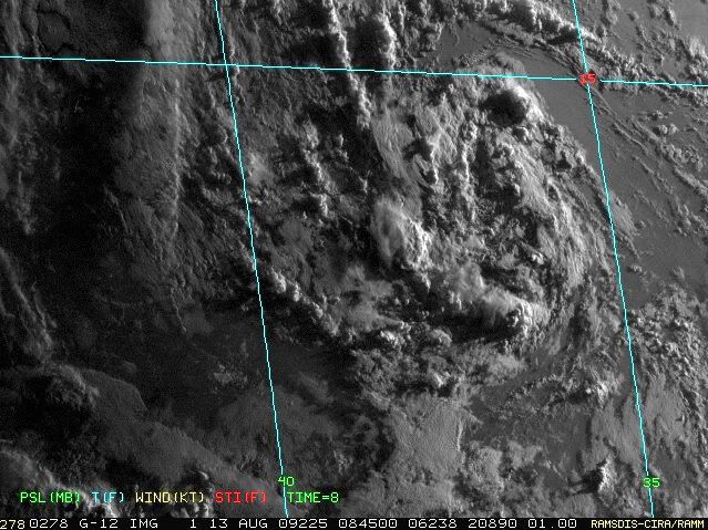
AT 1100 PM AST...0300 UTC...THE CENTER OF TROPICAL DEPRESSION TWO
WAS LOCATED NEAR LATITUDE 14.0 NORTH...LONGITUDE 36.3 WEST OR ABOUT
800 MILES...1285 KM...WEST OF THE SOUTHERNMOST CAPE VERDE ISLANDS.

THE DEPRESSION IS MOVING TOWARD THE WEST NEAR 14 MPH...22 KM/HR...
AND THIS GENERAL MOTION IS EXPECTED TO CONTINUE OVER THE NEXT
COUPLE OF DAYS.

MAXIMUM SUSTAINED WINDS ARE NEAR 35 MPH...55 KM/HR...WITH HIGHER
GUSTS. ALTHOUGH THE DEPRESSION APPEARS TO BE WEAKENING AT THIS
TIME...THE DEPRESSION STILL HAS THE POTENTIAL TO BECOME A TROPICAL
STORM IN A DAY OR TWO.

ESTIMATED MINIMUM CENTRAL PRESSURE IS 1006 MB...29.71 INCHES.

...SUMMARY OF 1100 PM AST INFORMATION...
LOCATION...14.0N 36.3W
MAXIMUM SUSTAINED WINDS...35 MPH
PRESENT MOVEMENT...WEST OR 260 DEGREES AT 14 MPH
MINIMUM CENTRAL PRESSURE...1006 MB

THE NEXT ADVISORY WILL BE ISSUED BY THE NATIONAL HURRICANE CENTER AT
500 AM AST.

$$
FORECASTER BERG


Image
0 likes   

User avatar
brunota2003
S2K Supporter
S2K Supporter
Posts: 9476
Age: 34
Joined: Sat Jul 30, 2005 9:56 pm
Location: Stanton, KY...formerly Havelock, NC
Contact:

#822 Postby brunota2003 » Wed Aug 12, 2009 9:49 pm

I still think 25 knots is better off than 30 knots at the moment.
0 likes   

User avatar
HURAKAN
Professional-Met
Professional-Met
Posts: 46086
Age: 38
Joined: Thu May 20, 2004 4:34 pm
Location: Key West, FL
Contact:

Re: ATL : TROPICAL DEPRESSION TWO

#823 Postby HURAKAN » Wed Aug 12, 2009 9:52 pm

Time will tell, but just in case, the Guillotine is ready!

Image
0 likes   

Cyclone1
Category 5
Category 5
Posts: 2739
Age: 33
Joined: Tue Jun 12, 2007 12:03 pm
Location: Florida

#824 Postby Cyclone1 » Wed Aug 12, 2009 9:54 pm

Ooof... looking rough.
0 likes   

CrazyC83
Professional-Met
Professional-Met
Posts: 34002
Joined: Tue Mar 07, 2006 11:57 pm
Location: Deep South, for the first time!

#825 Postby CrazyC83 » Wed Aug 12, 2009 9:54 pm

D.Max is critical for it. If it doesn't redevelop, I'd declare it a wave at the first visible.
0 likes   

User avatar
Evil Jeremy
S2K Supporter
S2K Supporter
Posts: 5463
Age: 32
Joined: Mon Apr 10, 2006 2:10 pm
Location: Los Angeles, CA

Re: ATL : TROPICAL DEPRESSION TWO

#826 Postby Evil Jeremy » Wed Aug 12, 2009 9:56 pm

For starters, I think that TD2 has 30 MPH winds, tops. With its lack of convection and bad circulation, its hard for me to believe this is still a 35 MPH depression.

Also, the cone is once again more south and more west in the long term. If TD2 actually survives, it might actually be a threat to the northern Caribbean if the cone keeps on moving south and west like it has been doing.

The discussion is very interesting this time around. It seems that the NHC might give up on this system soon: "ALL OF
THIS IS MOOT IF DEEP CONVECTION DOES NOT RE-DEVELOP SOON...IN WHICH
CASE WE WOULD LIKELY TERMINATE ADVISORIES."

Also interesting is how the NHC has been following the HWRF with the past few forecasts with TD2, they have said that in their discussions. Now it seems that they are no longer paying attention to it, as long as it remains the outlier: "THE HWRF WAS NOT INCLUDED IN THIS CONSENSUS SINCE IT
HAS BEEN A CONSISTENT NORTHERN OUTLIER FOR A COUPLE OF DAYS."
0 likes   

User avatar
HURAKAN
Professional-Met
Professional-Met
Posts: 46086
Age: 38
Joined: Thu May 20, 2004 4:34 pm
Location: Key West, FL
Contact:

Re:

#827 Postby HURAKAN » Wed Aug 12, 2009 10:04 pm

CrazyC83 wrote:D.Max is critical for it. If it doesn't redevelop, I'd declare it a wave at the first visible.


I agree. D-max is very important for TD 2.
0 likes   

User avatar
Gustywind
Category 5
Category 5
Posts: 12334
Joined: Mon Sep 03, 2007 7:29 am
Location: Baie-Mahault, GUADELOUPE

#828 Postby Gustywind » Wed Aug 12, 2009 10:10 pm

000
FXCA62 TJSJ 130246
AFDSJU

AREA FORECAST DISCUSSION
NATIONAL WEATHER SERVICE SAN JUAN PR
1046 PM AST WED AUG 12 2009

.UPDATE...


ABOUT TD TWO...FOR THE PAST THREE HOURS...TD TWO HAS STRUGGLES TO
KEEP ITS CONVECTIVE MOMENTUM AS IT DID EARLIER THIS AFTERNOON.
HOWEVER...THIS SYSTEM IS EXPECTED TO MOVE WESTWARD AND BECOME A TROPICAL STORM WITHIN THE NEXT 48 HOURS ACCORDING TO THE NATIONAL
HURRICANE CENTER. THIS SYSTEM IS PROJECTED TO PASS WELL TO THE
NORTHEAST OF THE LOCAL AREA BETWEEN LATE SUNDAY INTO MONDAY.


FOR MORE INFORMATION ABOUT WHAT IS GOING ON IN THE TROPIC...GO TO
THE NATIONAL HURRICANE CENTER WEBSITE AT HTTP://WWW.NHC.NOAA.GOV
.


&&

.AVIATION...


&&
0 likes   

User avatar
MGC
S2K Supporter
S2K Supporter
Posts: 5899
Joined: Sun Mar 23, 2003 9:05 pm
Location: Pass Christian MS, or what is left.

Re: ATL : TROPICAL DEPRESSION TWO

#829 Postby MGC » Wed Aug 12, 2009 11:20 pm

Can't give up on a TC until the circulation dissipates. Kyle back in 2002 went back and forth between TS and TD three times. Many times it looked like a naked swirl only to regain convection and reintensify....MGC
0 likes   

User avatar
Aquawind
Category 5
Category 5
Posts: 6714
Age: 62
Joined: Mon Jun 16, 2003 10:41 pm
Location: Salisbury, NC
Contact:

#830 Postby Aquawind » Wed Aug 12, 2009 11:26 pm

Yep.. Bring on the AM visable before we "wave" it off.. Evidently NHC is not to impressed with the enviroment ahead at this point being they keep it a TS at most anyways..
0 likes   

User avatar
David in FL
Tropical Low
Tropical Low
Posts: 28
Joined: Mon Aug 10, 2009 12:57 am
Location: Jacksonville Beach, FL

Re: ATL : TROPICAL DEPRESSION TWO

#831 Postby David in FL » Wed Aug 12, 2009 11:32 pm

Many storms have odne this. Lets quit saying TS by such and such, and see what happens. We have shear and dry air, but also its dipping south. might pick up, might diss. Who knows. At this point lets wait 12 to 24 and see what happens. Right now its weakened alot, but also has a couple times. This could be Andrew, could be fish, and could be nothing. I think a day or two will tell. Probly less time. Look like its deminished a lot. Low heights, and such. Just my newb opinion! The next organization isnt looking as good either
0 likes   

User avatar
Andrew92
S2K Supporter
S2K Supporter
Posts: 3247
Age: 41
Joined: Mon Jun 16, 2003 12:35 am
Location: Phoenix, Arizona

#832 Postby Andrew92 » Wed Aug 12, 2009 11:47 pm

Lest we also forget.....

Another tropical depression formed on August 13 four years ago only a little further to the west. It fizzled into an open wave the next day. While it appeared for a while it might not re-develop, sadly, we know that the rest is, unfortunately, history.

-Andrew92
0 likes   

RL3AO
Moderator-Pro Met
Moderator-Pro Met
Posts: 16308
Joined: Thu Jun 14, 2007 10:03 pm
Location: NC

#833 Postby RL3AO » Thu Aug 13, 2009 1:43 am

AL, 02, 2009081306, , BEST, 0, 140N, 365W, 30, 1007, TD
0 likes   

User avatar
KWT
Category 5
Category 5
Posts: 31415
Joined: Tue Aug 17, 2004 11:02 am
Location: UK!!!

#834 Postby KWT » Thu Aug 13, 2009 4:01 am

Still holding as a depression for now, will be interesting to see whether it can survive this rough patch.
0 likes   

User avatar
HURAKAN
Professional-Met
Professional-Met
Posts: 46086
Age: 38
Joined: Thu May 20, 2004 4:34 pm
Location: Key West, FL
Contact:

#835 Postby HURAKAN » Thu Aug 13, 2009 4:17 am

Image

Not good
0 likes   

User avatar
cycloneye
Admin
Admin
Posts: 145355
Age: 68
Joined: Thu Oct 10, 2002 10:54 am
Location: San Juan, Puerto Rico

Re: ATL : TROPICAL DEPRESSION TWO (Advisories)

#836 Postby cycloneye » Thu Aug 13, 2009 4:43 am

000
WTNT42 KNHC 130840
TCDAT2
TROPICAL DEPRESSION TWO DISCUSSION NUMBER 9
NWS TPC/NATIONAL HURRICANE CENTER MIAMI FL AL022009
500 AM AST THU AUG 13 2009

THE DEPRESSION HAS A RATHER MEAGER AMOUNT OF CONVECTION THIS MORNING
WITH JUST A FEW CELLS AROUND THE EXPOSED CENTER. SATELLITE
INTENSITY ESTIMATES ARE DROPPING...SO THE INITIAL INTENSITY IS
LOWERED TO 25 KT. IF SIGNIFICANT DEEP CONVECTION DOES NOT DEVELOP
SOON... THE SYSTEM COULD BE DECLARED A REMNANT LOW LATER TODAY.
ASSUMING THE DEPRESSION SURVIVES...THE ENVIRONMENT OVER THE NEXT
FEW DAYS IS MARGINALLY CONDUCIVE FOR SOME STRENGTHENING WITH
GRADUALLY INCREASING WATER TEMPERATURES WEST OF 40W AND PERHAPS A
DECREASE IN MODERATE SOUTHEASTERLY SHEAR. THE INTENSITY FORECAST
IS LOWERED FROM THE PREVIOUS ONE BUT STILL SHOWS THE DEPRESSION
EVENTUALLY BECOMING A TROPICAL STORM. THIS IS A PRETTY LOW
CONFIDENCE INTENSITY FORECAST AS THE DEPRESSION MAY NOT EVEN
SURVIVE THE DAY.

THE SYSTEM HAS BEEN MOVING SLOWER DURING THE PAST FEW HOURS...AND A
TWELVE-HOUR MOTION IS ESTIMATED AT 270/10. MOST OF THE GUIDANCE
SUGGEST THAT THIS WESTWARD MOTION SHOULD CONTINUE FOR A DAY OR SO
WITH A GRADUAL TURN TO THE WEST-NORTHWEST THEREAFTER AS A WEAKNESS
DEVELOPS IN THE SUBTROPICAL RIDGE. THE GLOBAL MODELS NOW INDICATE
THAT THE DEPRESSION COULD BE TOO FAR SOUTH TO BE AFFECTED
SIGNIFICANTLY BY THE WEAKNESS IN THE RIDGE AND HAVE SHIFTED THE
TRACK EQUATORWARD AS A RESULT. THE HWRF CONTINUES ON ITS OWN BY
MOVING THE SYSTEM MORE TO THE NORTH...WHILE THE REST OF THE
GUIDANCE IS PRETTY WELL-CLUSTERED ON A MORE SOUTHERN PATH. THE
OFFICIAL FORECAST IS ADJUSTED SOUTHWARD AND WITH MANY RELIABLE
MODELS STILL SOUTH OF THE NHC TRACK...IT WOULD NOT BE SURPRISING TO
SEE THE FORECAST MOVE FARTHER SOUTH LATER ON.


FORECAST POSITIONS AND MAX WINDS

INITIAL 13/0900Z 14.0N 36.9W 25 KT
12HR VT 13/1800Z 14.0N 38.5W 25 KT
24HR VT 14/0600Z 14.2N 40.7W 30 KT
36HR VT 14/1800Z 14.4N 43.0W 35 KT
48HR VT 15/0600Z 14.9N 45.9W 40 KT
72HR VT 16/0600Z 16.5N 52.0W 40 KT
96HR VT 17/0600Z 19.0N 59.0W 40 KT
120HR VT 18/0600Z 22.5N 65.0W 35 KT

$$
FORECASTER BLAKE
0 likes   

curtadams
S2K Supporter
S2K Supporter
Posts: 1122
Joined: Sun Aug 28, 2005 7:57 pm
Location: Orange, California
Contact:

#837 Postby curtadams » Thu Aug 13, 2009 5:59 am

After having virtually no convection during d-min this is just a tropical low. If it had never been more than this NHC wouldn't be even considering calling it a TD and nobody would be complaining about that either.

Of course it could theoretically develop into a monster hurricane in the future but that means nothing. An open wave can develop too.
0 likes   

User avatar
Thunder44
Category 5
Category 5
Posts: 5922
Age: 44
Joined: Mon Jun 09, 2003 7:53 pm
Location: New York City

Re: ATL : TROPICAL DEPRESSION TWO

#838 Postby Thunder44 » Thu Aug 13, 2009 6:10 am

Too much shear and dry into the system now. I think 90L now has better shot at being named Ana than this one.
0 likes   

OuterBanker
S2K Supporter
S2K Supporter
Posts: 1731
Joined: Wed Feb 26, 2003 10:53 am
Location: Nags Head, NC
Contact:

#839 Postby OuterBanker » Thu Aug 13, 2009 8:41 am

Hmmm, wonderful l LLC, completely void of convection.

Blobologist have written it off, mets are saying wait a minute.

All I can see is the scene in a Monty Python movie where a character is waving his hands and saying "I'm not dead yet".

I have seen worse survive. But with all the dry air I have my doubts.
0 likes   

User avatar
drezee
S2K Supporter
S2K Supporter
Posts: 3664
Joined: Mon Jun 09, 2003 12:49 pm
Location: FL

Re: ATL : TROPICAL DEPRESSION TWO

#840 Postby drezee » Thu Aug 13, 2009 8:45 am

little pop over the center at 1315...

http://hadar.cira.colostate.edu/ramsdis ... al/287.jpg
0 likes   


Return to “2009”

Who is online

Users browsing this forum: No registered users and 3 guests