ATL: TROPICAL LOW ex-FRED (ex-07L)

Moderator: S2k Moderators

Message
Author
User avatar
HURAKAN
Professional-Met
Professional-Met
Posts: 46086
Age: 37
Joined: Thu May 20, 2004 4:34 pm
Location: Key West, FL
Contact:

#81 Postby HURAKAN » Mon Sep 07, 2009 6:29 am

Image

Latest
0 likes   

User avatar
senorpepr
Military Met/Moderator
Posts: 12542
Age: 41
Joined: Fri Aug 22, 2003 9:22 pm
Location: Mackenbach, Germany
Contact:

#82 Postby senorpepr » Mon Sep 07, 2009 6:40 am

ABNT20 KNHC 071139
TWOAT
TROPICAL WEATHER OUTLOOK
NWS TPC/NATIONAL HURRICANE CENTER MIAMI FL
800 AM EDT MON SEP 7 2009

FOR THE NORTH ATLANTIC...CARIBBEAN SEA AND THE GULF OF MEXICO...

A BROAD AREA OF LOW PRESSURE ASSOCIATED WITH A STRONG TROPICAL WAVE
IS LOCATED ABOUT 200 MILES SOUTH-SOUTHEAST OF THE SOUTHERN CAPE
VERDE ISLANDS. SHOWER AND THUNDERSTORMS ACTIVITY ASSOCIATED WITH
THIS SYSTEM IS SHOWING SIGNS OF ORGANIZATION. CONDITIONS APPEAR
FAVORABLE FOR THE LOW TO DEVELOP INTO A TROPICAL DEPRESSION LATER
TODAY OR TONIGHT AS IT MOVES WEST OR WEST-NORTHWESTWARD AT NEAR 20
MPH. LOCALLY HEAVY SHOWERS AND STRONG GUSTY WINDS ARE LIKELY OVER
THE SOUTHERN CAPE VERDE ISLANDS TODAY. THERE IS A HIGH CHANCE...
GREATER THAN 50 PERCENT...OF THIS SYSTEM BECOMING A TROPICAL
CYCLONE DURING THE NEXT 48 HOURS.


A TROUGH OF LOW PRESSURE LOCATED JUST OFF THE COAST OF NORTH AND
SOUTH CAROLINA IS PRODUCING AN AREA OF DISORGANIZED SHOWERS AND
THUNDERSTORMS. UPPER-LEVEL WINDS ARE EXPECTED TO REMAIN
UNFAVORABLE FOR SIGNIFICANT TROPICAL CYCLONE FORMATION AS THIS
SYSTEM MOVES NORTH-NORTHEASTWARD. THERE IS A LOW CHANCE...
LESS THAN 30 PERCENT...OF THIS SYSTEM BECOMING A TROPICAL
CYCLONE DURING THE NEXT 48 HOURS.

ELSEWHERE...TROPICAL CYCLONE FORMATION IS NOT EXPECTED DURING THE
NEXT 48 HOURS.

$$
FORECASTER BROWN
0 likes   

User avatar
Gustywind
Category 5
Category 5
Posts: 12334
Joined: Mon Sep 03, 2007 7:29 am
Location: Baie-Mahault, GUADELOUPE

#83 Postby Gustywind » Mon Sep 07, 2009 6:55 am

:uarrow:
Image

Image
0 likes   

User avatar
HURAKAN
Professional-Met
Professional-Met
Posts: 46086
Age: 37
Joined: Thu May 20, 2004 4:34 pm
Location: Key West, FL
Contact:

#84 Postby HURAKAN » Mon Sep 07, 2009 7:06 am

Image

Latest
0 likes   

User avatar
HURAKAN
Professional-Met
Professional-Met
Posts: 46086
Age: 37
Joined: Thu May 20, 2004 4:34 pm
Location: Key West, FL
Contact:

#85 Postby HURAKAN » Mon Sep 07, 2009 7:11 am

Image

Shear
0 likes   

User avatar
wxman57
Moderator-Pro Met
Moderator-Pro Met
Posts: 22506
Age: 66
Joined: Sat Jun 21, 2003 8:06 pm
Location: Houston, TX (southwest)

Re: ATL : INVEST 96L

#86 Postby wxman57 » Mon Sep 07, 2009 7:21 am

My impression is that it looks less impressive than yesterday. Still a fair chance of developing, but no threat to any land areas (after producing rain in southern Cape Verde Islands today).
0 likes   

User avatar
cycloneye
Admin
Admin
Posts: 139602
Age: 67
Joined: Thu Oct 10, 2002 10:54 am
Location: San Juan, Puerto Rico

Re: ATL : INVEST 96L

#87 Postby cycloneye » Mon Sep 07, 2009 7:22 am

SSD Dvorak.

07/1145 UTC 11.9N 21.7W T1.0/1.0 96L -- Atlantic
0 likes   

User avatar
senorpepr
Military Met/Moderator
Posts: 12542
Age: 41
Joined: Fri Aug 22, 2003 9:22 pm
Location: Mackenbach, Germany
Contact:

#88 Postby senorpepr » Mon Sep 07, 2009 7:53 am

No big changes w/ the 12Z best track position:

AL, 96, 2009090712, , BEST, 0, 120N, 219W, 25, 1007, DB, 0, , 0, 0, 0, 0,
0 likes   

User avatar
senorpepr
Military Met/Moderator
Posts: 12542
Age: 41
Joined: Fri Aug 22, 2003 9:22 pm
Location: Mackenbach, Germany
Contact:

Re:

#89 Postby senorpepr » Mon Sep 07, 2009 7:54 am

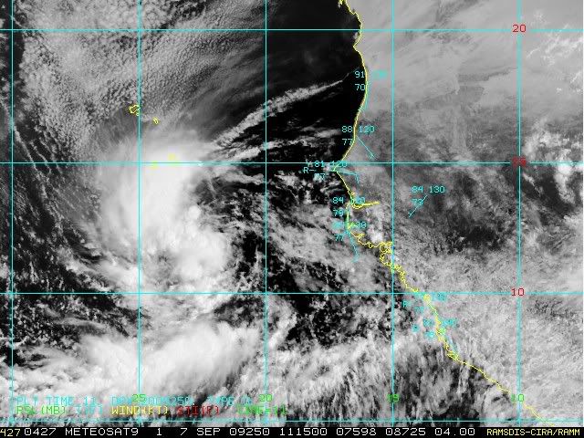
senorpepr wrote:No big changes w/ the 12Z best track position:

AL, 96, 2009090712, , BEST, 0, 120N, 219W, 25, 1007, DB, 0, , 0, 0, 0, 0,


After further review, the 12Z updated it shift the previous path about a degree further south.
0 likes   

User avatar
cycloneye
Admin
Admin
Posts: 139602
Age: 67
Joined: Thu Oct 10, 2002 10:54 am
Location: San Juan, Puerto Rico

Re: ATL : INVEST 96L

#90 Postby cycloneye » Mon Sep 07, 2009 8:00 am

:uarrow: That is very interesting the further south positions of both SSD dvorak and Best track.
0 likes   

User avatar
wxman57
Moderator-Pro Met
Moderator-Pro Met
Posts: 22506
Age: 66
Joined: Sat Jun 21, 2003 8:06 pm
Location: Houston, TX (southwest)

Re: ATL : INVEST 96L

#91 Postby wxman57 » Mon Sep 07, 2009 8:09 am

cycloneye wrote::uarrow: That is very interesting the further south positions of both SSD dvorak and Best track.


It doesn't matter, chcloneye. This system is heading out to sea well east of the Caribbean no matter where it starts out.

On high-res visible, I would put the center at 13Z near 12.3N/22.8W. Just in the past hour, I'm seeing a little more banding with some convection now east of the center. Lat/Lon at bottom of image represent crosshairs position.

Image
0 likes   

User avatar
HURAKAN
Professional-Met
Professional-Met
Posts: 46086
Age: 37
Joined: Thu May 20, 2004 4:34 pm
Location: Key West, FL
Contact:

#92 Postby HURAKAN » Mon Sep 07, 2009 8:21 am

0 likes   

User avatar
BigA
Professional-Met
Professional-Met
Posts: 1317
Joined: Sun Jul 24, 2005 10:56 pm

Re: ATL : INVEST 96L - Computer Models

#93 Postby BigA » Mon Sep 07, 2009 8:49 am

Euro keeps this thing around for a LONG time...the 240 hour forecast has 96L as a hurricane moving back westward at around 30 north. Now, I think we can all agree that a big, strong, long-lasting, ACE-boosting Fred fish would help this season's overall numbers.
0 likes   

User avatar
expat2carib
S2K Supporter
S2K Supporter
Posts: 458
Joined: Tue Jul 22, 2008 1:44 pm
Location: Sint Maarten

Re: ATL : INVEST 96L

#94 Postby expat2carib » Mon Sep 07, 2009 9:12 am

Fish Fred on it's way. Let me introduce Fred Sharkstone.
Image
0 likes   

User avatar
HURAKAN
Professional-Met
Professional-Met
Posts: 46086
Age: 37
Joined: Thu May 20, 2004 4:34 pm
Location: Key West, FL
Contact:

#95 Postby HURAKAN » Mon Sep 07, 2009 9:16 am

Image

very nice LLC
0 likes   

Frank2
Category 5
Category 5
Posts: 4061
Joined: Mon Jul 25, 2005 12:47 pm

#96 Postby Frank2 » Mon Sep 07, 2009 9:32 am

Uh-oh - at first I laughed at the picture of Fred Flintstone, but then remembered some on this very same web site posted similar pictures of his wife (Wilma), almost 4 years ago when that system was in it's early stages - and we know what happened with that hurricane (for me, it meant 10 days in a hotel)...

Granted, in 2005 we could spin up a hurricane with a $1.79 plunger (LOL), but you never know...

Frank
0 likes   

User avatar
somethingfunny
ChatStaff
ChatStaff
Posts: 3926
Age: 35
Joined: Thu May 31, 2007 10:30 pm
Location: McKinney, Texas

Re: ATL : INVEST 96L

#97 Postby somethingfunny » Mon Sep 07, 2009 9:50 am

Image

Not that I'm convinced this will be Fred yet.
0 likes   

Sanibel
Category 5
Category 5
Posts: 10348
Joined: Mon Aug 30, 2004 11:06 pm
Location: Offshore SW Florida

Re: ATL : INVEST 96L

#98 Postby Sanibel » Mon Sep 07, 2009 9:57 am

Will it develop? Will it track west? Stay tuned tomorrow same time, same station, for the next episode of 'As The Storm Turns'...
0 likes   

jlauderdal
S2K Supporter
S2K Supporter
Posts: 6813
Joined: Wed May 19, 2004 5:46 am
Location: NE Fort Lauderdale
Contact:

Re: ATL : INVEST 96L

#99 Postby jlauderdal » Mon Sep 07, 2009 10:16 am

my first, only and last post about this system. NEXT!


Image
0 likes   

Frank2
Category 5
Category 5
Posts: 4061
Joined: Mon Jul 25, 2005 12:47 pm

#100 Postby Frank2 » Mon Sep 07, 2009 10:54 am

It's one of those years when activity is at a minimum (or the opposite of 2005), so it's a good thing...

I'm tempted to say the season's over, but it's too early for that...

Frank2
0 likes   


Return to “2009”

Who is online

Users browsing this forum: No registered users and 9 guests