WPAC : TROPICAL DEPRESSION MIRINAE (23W)

Moderator: S2k Moderators

Message
Author
oaba09
S2K Supporter
S2K Supporter
Posts: 1496
Age: 38
Joined: Thu Oct 01, 2009 10:02 am
Location: Valenzuela, Philippines
Contact:

Re: Re:

#541 Postby oaba09 » Tue Oct 27, 2009 10:31 am

drdavisjr wrote:
oaba09 wrote:Now that's just pathetic.......Can't they even admit when they make mistakes??


It's not just pathetic and disgusting, it's dangerous.


Yeah exactly...They're putting the lives of people in danger by giving false information........
0 likes   

User avatar
drdavisjr
Category 1
Category 1
Posts: 428
Age: 57
Joined: Mon Oct 12, 2009 7:07 am
Location: Marilao, Bulacan, Philippines
Contact:

#542 Postby drdavisjr » Tue Oct 27, 2009 10:36 am

Guys, good night! (good afternoon to all in the west) I have to get 2 projects completed before Saturday (stormday, since I doubt we'll have internet or power for a few days), so I have to get some sleep now. I'll be around from time to time tomorrow...
0 likes   

oaba09
S2K Supporter
S2K Supporter
Posts: 1496
Age: 38
Joined: Thu Oct 01, 2009 10:02 am
Location: Valenzuela, Philippines
Contact:

Re:

#543 Postby oaba09 » Tue Oct 27, 2009 10:38 am

drdavisjr wrote:Guys, good night! (good afternoon to all in the west) I have to get 2 projects completed before Saturday (stormday, since I doubt we'll have internet or power for a few days), so I have to get some sleep now. I'll be around from time to time tomorrow...


Good night and good luck! :D
0 likes   

oaba09
S2K Supporter
S2K Supporter
Posts: 1496
Age: 38
Joined: Thu Oct 01, 2009 10:02 am
Location: Valenzuela, Philippines
Contact:

#544 Postby oaba09 » Tue Oct 27, 2009 10:43 am

Well.......I think I'll be going to bed now.......sooo sleepy...night guys!
0 likes   

User avatar
HURAKAN
Professional-Met
Professional-Met
Posts: 46086
Age: 38
Joined: Thu May 20, 2004 4:34 pm
Location: Key West, FL
Contact:

Re:

#545 Postby HURAKAN » Tue Oct 27, 2009 10:45 am

oaba09 wrote:Well.......I think I'll be going to bed now.......sooo sleepy...night guys!


Too early to sleep, almost noon!!!! jk
0 likes   

User avatar
breeze
Category 5
Category 5
Posts: 9110
Age: 62
Joined: Sat Feb 08, 2003 4:55 pm
Location: Lawrenceburg, TN

Re: WPAC : TROPICAL STORM MIRINAE (23W)

#546 Postby breeze » Tue Oct 27, 2009 10:46 am

Good night, guys... :D
0 likes   

User avatar
HURAKAN
Professional-Met
Professional-Met
Posts: 46086
Age: 38
Joined: Thu May 20, 2004 4:34 pm
Location: Key West, FL
Contact:

#547 Postby HURAKAN » Tue Oct 27, 2009 10:54 am

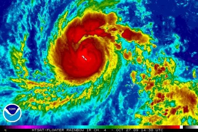
Image

Latest
0 likes   

User avatar
HURAKAN
Professional-Met
Professional-Met
Posts: 46086
Age: 38
Joined: Thu May 20, 2004 4:34 pm
Location: Key West, FL
Contact:

#548 Postby HURAKAN » Tue Oct 27, 2009 11:25 am

Image

beautiful shape
0 likes   

User avatar
metenthusiast
Category 1
Category 1
Posts: 271
Age: 48
Joined: Sun Oct 18, 2009 1:09 am
Location: Manila, Phllippines
Contact:

Re:

#549 Postby metenthusiast » Tue Oct 27, 2009 12:23 pm

HURAKAN wrote:Image

beautiful shape


Yeah! It's more solid and consolidated than the ones I've seen. It also doesn't have too much outer spiral thing (don't know what it's called... rain band, I guess). Is this BAD or GOOD? Intensity-wise?
0 likes   

User avatar
cycloneye
Admin
Admin
Posts: 145348
Age: 68
Joined: Thu Oct 10, 2002 10:54 am
Location: San Juan, Puerto Rico

Re: WPAC : TROPICAL STORM MIRINAE (23W)

#550 Postby cycloneye » Tue Oct 27, 2009 1:28 pm

It looks like it is increasing in intensity in a fairly fast pace.Lets see what JMA and JTWC have soon in their warnings.

Image
0 likes   
Visit the Caribbean-Central America Weather Thread where you can find at first post web cams,radars
and observations from Caribbean basin members Click Here

cebuboy
Tropical Depression
Tropical Depression
Posts: 94
Joined: Wed Sep 30, 2009 5:29 am
Location: Cebu, Philippines

Re: WPAC : TROPICAL STORM MIRINAE (23W)

#551 Postby cebuboy » Tue Oct 27, 2009 1:41 pm

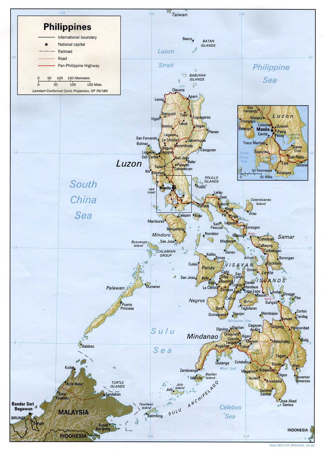
cycloneye wrote:Those people who live at Polillo islands will see a high storm surge.


I am afraid of this. I pray the wind will not be as strong to cause some storm surge. There are lot of good families living there.
0 likes   

cebuboy
Tropical Depression
Tropical Depression
Posts: 94
Joined: Wed Sep 30, 2009 5:29 am
Location: Cebu, Philippines

Re: WPAC : TROPICAL STORM MIRINAE (23W)

#552 Postby cebuboy » Tue Oct 27, 2009 1:45 pm

JTE50 wrote:
metenthusiast wrote:
drdavisjr wrote:Image

Interesting, they have the ridge weakening on day 4 to allow for a west nothwest movement and miss Metro Manila.


Good evening guys! (Good morning to our friends in the west! :D ). I think it wouldn't matter much whether it would hit Metro Manila directly or not. Based on what I read, this system would intensify into a 115-knot storm before it hits land due to the favorable condition the Philippine Sea would give it. By the time it makes it westward march across the island of Luzon, it has already gained strength that I'm sure won't dissipate that quickly. And the rest I'm leaving to your imagination.

No. I think it's not a question of where and when exactly it would hit anymore. The real question would be as to how we would weather it out.


I agree, it's looking more and more likely a Philippine hit - especially if it's moves south of west. The only good part about the track is it won't be crawling along and dumping a lot more rain - well, that's the way it looks right now. I suppose it's impossible to get to the eastern coast with that mountain range in the way correct?


I think there is a so called "habal habal" we called here in Philippines. It is a form of rough motorcycle ride to cross mountains and you have to pay for it. The problem is , you can only bring at most two persons with you along with your camera equipments if you have.
0 likes   

User avatar
cycloneye
Admin
Admin
Posts: 145348
Age: 68
Joined: Thu Oct 10, 2002 10:54 am
Location: San Juan, Puerto Rico

Re: WPAC : TROPICAL STORM MIRINAE (23W)

#553 Postby cycloneye » Tue Oct 27, 2009 1:46 pm

cebuboy wrote:
cycloneye wrote:Those people who live at Polillo islands will see a high storm surge.


I am afraid of this. I pray the wind will not be as strong to cause some storm surge. There are lot of good families living there.


Here is a graphic for those members who dont know where Polillo Islands are located.

Click symbol to get a big closeup.

Image
0 likes   
Visit the Caribbean-Central America Weather Thread where you can find at first post web cams,radars
and observations from Caribbean basin members Click Here

User avatar
cycloneye
Admin
Admin
Posts: 145348
Age: 68
Joined: Thu Oct 10, 2002 10:54 am
Location: San Juan, Puerto Rico

Re: WPAC : TROPICAL STORM MIRINAE (23W)

#554 Postby cycloneye » Tue Oct 27, 2009 1:48 pm

JMA 18 UTC Warning=Upgrades to Severe Tropical Storm

STS 0921 (Mirinae)
Issued at 18:40 UTC, 27 October 2009
<Analyses at 27/18 UTC>
Scale -
Intensity -
Center position N15°55'(15.9°)
E140°20'(140.3°)
Direction and speed of movement W 30km/h(15kt)
Central pressure 985hPa
Maximum wind speed near the center 25m/s(50kt)
Maximum wind gust speed 35m/s(70kt)
Area of 30kt winds or more Wide 260km(140NM)

<Forecast for 28/18 UTC>
Intensity Strong
Center position of probability circle N16°05'(16.1°)
E134°30'(134.5°)
Direction and speed of movement W 25km/h(14kt)
Central pressure 970hPa
Maximum wind speed near the center 35m/s(65kt)
Maximum wind gust speed 50m/s(95kt)
Radius of probability circle 140km(75NM)
Storm warning area Wide 220km(120NM)

<Forecast for 29/18 UTC>
Intensity Strong
Center position of probability circle N16°00'(16.0°)
E129°05'(129.1°)
Direction and speed of movement W 25km/h(13kt)
Central pressure 950hPa
Maximum wind speed near the center 40m/s(80kt)
Maximum wind gust speed 60m/s(115kt)
Radius of probability circle 260km(140NM)
Storm warning area Wide 390km(210NM)

<Forecast for 30/18 UTC>
Intensity Very Strong
Center position of probability circle N15°30'(15.5°)
E124°10'(124.2°)
Direction and speed of movement W 20km/h(12kt)
Central pressure 940hPa
Maximum wind speed near the center 45m/s(85kt)
Maximum wind gust speed 60m/s(120kt)
Radius of probability circle 390km(210NM)
Storm warning area Wide 540km(290NM)

Image
0 likes   
Visit the Caribbean-Central America Weather Thread where you can find at first post web cams,radars
and observations from Caribbean basin members Click Here

cebuboy
Tropical Depression
Tropical Depression
Posts: 94
Joined: Wed Sep 30, 2009 5:29 am
Location: Cebu, Philippines

Re: Re:

#555 Postby cebuboy » Tue Oct 27, 2009 1:52 pm

oaba09 wrote:Now that's just pathetic.......Can't they even admit when they make mistakes??


They use to it. I remember the time (very long ago) they also predict a strong typhoon to pass over Visayas (cebu city area), we are alarmed, panicked and initiate a full blow preparation, yet we are waiting for it ---in sweat (hot sunny weather) and the storm never pass by even with rains. Thanks God it don't but its inaccuracy that catches my attention.
0 likes   

User avatar
breeze
Category 5
Category 5
Posts: 9110
Age: 62
Joined: Sat Feb 08, 2003 4:55 pm
Location: Lawrenceburg, TN

Re: WPAC : SEVERE TROPICAL STORM MIRINAE (23W)

#556 Postby breeze » Tue Oct 27, 2009 2:06 pm

Wow, look at the wind speeds and max wind gusts on the 30th - and the track is holding
toward central Luzon. I hope that ends up being wrong!
0 likes   

User avatar
cycloneye
Admin
Admin
Posts: 145348
Age: 68
Joined: Thu Oct 10, 2002 10:54 am
Location: San Juan, Puerto Rico

Re: WPAC : SEVERE TROPICAL STORM MIRINAE (23W)

#557 Postby cycloneye » Tue Oct 27, 2009 2:10 pm

Jeff,Pocillo Island may be ground zero for you to chase as the tracks continue to go that way.The problem is if the tracks change at the last minute and you only get hot air.I think that is better for you to be in Luzon and decide there where to go.
0 likes   
Visit the Caribbean-Central America Weather Thread where you can find at first post web cams,radars
and observations from Caribbean basin members Click Here

Derek Ortt

#558 Postby Derek Ortt » Tue Oct 27, 2009 2:39 pm

I think the gusts may be closer to 140KT by then, not 120KT
0 likes   

User avatar
cycloneye
Admin
Admin
Posts: 145348
Age: 68
Joined: Thu Oct 10, 2002 10:54 am
Location: San Juan, Puerto Rico

Re: WPAC : SEVERE TROPICAL STORM MIRINAE (23W)

#559 Postby cycloneye » Tue Oct 27, 2009 3:10 pm

2100z JTWC Warning=Upgrades to Typhoon

WTPN32 PGTW 272100
MSGID/GENADMIN/NAVMARFCSTCEN PEARL HARBOR HI/JTWC//
SUBJ/TROPICAL CYCLONE WARNING//
RMKS/
1. TYPHOON 23W (MIRINAE) WARNING NR 008
UPGRADED FROM TROPICAL STORM 23W
01 ACTIVE TROPICAL CYCLONE IN NORTHWESTPAC
MAX SUSTAINED WINDS BASED ON ONE-MINUTE AVERAGE
WIND RADII VALID OVER OPEN WATER ONLY
---
WARNING POSITION:
271800Z --- NEAR 15.9N 140.2E
MOVEMENT PAST SIX HOURS - 280 DEGREES AT 19 KTS
POSITION ACCURATE TO WITHIN 060 NM
POSITION BASED ON CENTER LOCATED BY SATELLITE
PRESENT WIND DISTRIBUTION:
MAX SUSTAINED WINDS - 065 KT, GUSTS 080 KT
WIND RADII VALID OVER OPEN WATER ONLY
RADIUS OF 050 KT WINDS - 025 NM NORTHEAST QUADRANT
025 NM SOUTHEAST QUADRANT
025 NM SOUTHWEST QUADRANT
025 NM NORTHWEST QUADRANT
RADIUS OF 034 KT WINDS - 060 NM NORTHEAST QUADRANT
050 NM SOUTHEAST QUADRANT
065 NM SOUTHWEST QUADRANT
065 NM NORTHWEST QUADRANT
REPEAT POSIT: 15.9N 140.2E
---
FORECASTS:
12 HRS, VALID AT:
280600Z --- 16.5N 136.7E
MAX SUSTAINED WINDS - 075 KT, GUSTS 090 KT
WIND RADII VALID OVER OPEN WATER ONLY
RADIUS OF 064 KT WINDS - 010 NM NORTHEAST QUADRANT
010 NM SOUTHEAST QUADRANT
010 NM SOUTHWEST QUADRANT
010 NM NORTHWEST QUADRANT
RADIUS OF 050 KT WINDS - 035 NM NORTHEAST QUADRANT
035 NM SOUTHEAST QUADRANT
035 NM SOUTHWEST QUADRANT
035 NM NORTHWEST QUADRANT
RADIUS OF 034 KT WINDS - 080 NM NORTHEAST QUADRANT
070 NM SOUTHEAST QUADRANT
080 NM SOUTHWEST QUADRANT
085 NM NORTHWEST QUADRANT
VECTOR TO 24 HR POSIT: 275 DEG/ 16 KTS
---
24 HRS, VALID AT:
281800Z --- 16.9N 133.3E
MAX SUSTAINED WINDS - 085 KT, GUSTS 105 KT
WIND RADII VALID OVER OPEN WATER ONLY
RADIUS OF 064 KT WINDS - 020 NM NORTHEAST QUADRANT
020 NM SOUTHEAST QUADRANT
020 NM SOUTHWEST QUADRANT
020 NM NORTHWEST QUADRANT
RADIUS OF 050 KT WINDS - 045 NM NORTHEAST QUADRANT
045 NM SOUTHEAST QUADRANT
045 NM SOUTHWEST QUADRANT
045 NM NORTHWEST QUADRANT
RADIUS OF 034 KT WINDS - 095 NM NORTHEAST QUADRANT
085 NM SOUTHEAST QUADRANT
095 NM SOUTHWEST QUADRANT
100 NM NORTHWEST QUADRANT
VECTOR TO 36 HR POSIT: 275 DEG/ 13 KTS
---
36 HRS, VALID AT:
290600Z --- 17.2N 130.5E
MAX SUSTAINED WINDS - 090 KT, GUSTS 110 KT
WIND RADII VALID OVER OPEN WATER ONLY
RADIUS OF 064 KT WINDS - 025 NM NORTHEAST QUADRANT
025 NM SOUTHEAST QUADRANT
025 NM SOUTHWEST QUADRANT
025 NM NORTHWEST QUADRANT
RADIUS OF 050 KT WINDS - 050 NM NORTHEAST QUADRANT
050 NM SOUTHEAST QUADRANT
050 NM SOUTHWEST QUADRANT
055 NM NORTHWEST QUADRANT
RADIUS OF 034 KT WINDS - 105 NM NORTHEAST QUADRANT
100 NM SOUTHEAST QUADRANT
105 NM SOUTHWEST QUADRANT
110 NM NORTHWEST QUADRANT
VECTOR TO 48 HR POSIT: 270 DEG/ 13 KTS
---
EXTENDED OUTLOOK:
48 HRS, VALID AT:
291800Z --- 17.2N 127.7E
MAX SUSTAINED WINDS - 095 KT, GUSTS 115 KT
WIND RADII VALID OVER OPEN WATER ONLY
RADIUS OF 064 KT WINDS - 030 NM NORTHEAST QUADRANT
030 NM SOUTHEAST QUADRANT
030 NM SOUTHWEST QUADRANT
030 NM NORTHWEST QUADRANT
RADIUS OF 050 KT WINDS - 055 NM NORTHEAST QUADRANT
055 NM SOUTHEAST QUADRANT
055 NM SOUTHWEST QUADRANT
060 NM NORTHWEST QUADRANT
RADIUS OF 034 KT WINDS - 110 NM NORTHEAST QUADRANT
105 NM SOUTHEAST QUADRANT
110 NM SOUTHWEST QUADRANT
115 NM NORTHWEST QUADRANT
VECTOR TO 72 HR POSIT: 265 DEG/ 09 KTS
---
72 HRS, VALID AT:
301800Z --- 16.8N 124.0E
MAX SUSTAINED WINDS - 100 KT, GUSTS 125 KT
WIND RADII VALID OVER OPEN WATER ONLY
RADIUS OF 064 KT WINDS - 035 NM NORTHEAST QUADRANT
035 NM SOUTHEAST QUADRANT
035 NM SOUTHWEST QUADRANT
035 NM NORTHWEST QUADRANT
RADIUS OF 050 KT WINDS - 060 NM NORTHEAST QUADRANT
060 NM SOUTHEAST QUADRANT
060 NM SOUTHWEST QUADRANT
065 NM NORTHWEST QUADRANT
RADIUS OF 034 KT WINDS - 120 NM NORTHEAST QUADRANT
115 NM SOUTHEAST QUADRANT
120 NM SOUTHWEST QUADRANT
125 NM NORTHWEST QUADRANT
VECTOR TO 96 HR POSIT: 265 DEG/ 07 KTS
---
LONG RANGE OUTLOOK:
NOTE...ERRORS FOR TRACK HAVE AVERAGED NEAR 250 NM
ON DAY 4 AND 350 NM ON DAY 5... AND FOR INTENSITY
NEAR 20 KT EACH DAY.
---
96 HRS, VALID AT:
311800Z --- 16.4N 120.9E
MAX SUSTAINED WINDS - 075 KT, GUSTS 090 KT
WIND RADII VALID OVER OPEN WATER ONLY
VECTOR TO 120 HR POSIT: 265 DEG/ 09 KTS
---
120 HRS, VALID AT:
011800Z --- 16.1N 117.3E
MAX SUSTAINED WINDS - 070 KT, GUSTS 085 KT
WIND RADII VALID OVER OPEN WATER ONLY
---
REMARKS:
272100Z POSITION NEAR 16.1N 139.3E.
TYPHOON (TY) 23W (MIRINAE), LOCATED APPROXIMATELY 305 NM WEST-
NORTHWEST OF GUAM, HAS TRACKED WESTWARD AT 17 KNOTS OVER THE PAST
SIX HOURS. ANIMATED INFRARED SATELLITE IMAGERY AND A 271638Z AMSR-E
IMAGE SHOW A SIGNIFICANT INCREASE IN ORGANIZATION AND INTENSITY OVER
THE PAST 06 HOURS. A WELL DEFINED MICROWAVE EYE IS EVIDENT IN THE
AMSR-E PASS WITH DEEP CONVECTION EXTENDING COMPLETELY AROUND THE
SOUTHERN HALF OF MIRINAE. UPPER LEVEL ANALYSIS SHOWS THAT THE
POLEWARD OUTFLOW CHANNEL HAS LINKED WITH THE MID-LATITUDE TROUGH TO
THE NORTH OF MIRINAE AND HAS HELPED TO FUEL RAPID INTENSIFICATION
OVER THE PAST 06 HOURS. THE INFLUENCE FROM THE TROUGH ON THE
POLEWARD OUTFLOW WILL BEGIN TO DIMINISH OVER THE NEXT 12 TO 24 HOURS
AS THE MID-LATITUDE FLOW RE-ALIGNS AND BECOMES MORE ZONAL. TY 23W IS
EXPECTED TO CONTINUE STRENGTHENING THROUGH TAU 72 PRIOR TO LANDFALL
WITH LUZON; DECREASING AS IT TRACKS OVER LUZON INTO THE SOUTH CHINA
SEA. LAND INTERACTION WILL SLOW MIRINAE FROM TAU 72 THROUGH 120 AS
IT TRACKS OVER LUZON, BUT THE CYCLONE WILL SEE A SLIGHT INCREASE IN
TRACK SPEED UPON RE-ENTERING THE SOUTH CHINA SEA. MAXIMUM
SIGNIFICANT WAVE HEIGHT AT 271800Z IS 17 FEET. NEXT WARNINGS AT
280300Z, 280900Z, 281500Z AND 282100Z.//

Image
0 likes   
Visit the Caribbean-Central America Weather Thread where you can find at first post web cams,radars
and observations from Caribbean basin members Click Here

User avatar
HURAKAN
Professional-Met
Professional-Met
Posts: 46086
Age: 38
Joined: Thu May 20, 2004 4:34 pm
Location: Key West, FL
Contact:

#560 Postby HURAKAN » Tue Oct 27, 2009 3:15 pm

Image

Latest
0 likes   


Return to “2009”

Who is online

Users browsing this forum: No registered users and 11 guests