CrazyC83 wrote:Could this shoot up the Gulf of California and impact the US Southwest heavily?
It could impact the US SW with some heavy rain and flooding. But, it will not be a wind event by then.
Moderator: S2k Moderators
CrazyC83 wrote:Could this shoot up the Gulf of California and impact the US Southwest heavily?
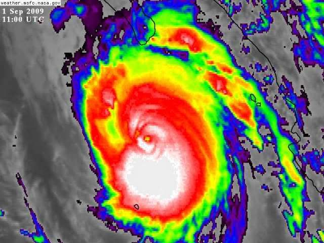
CrazyC83 wrote:cycloneye wrote:Post season upgrade to cat 5.
It's pretty much certain, perhaps on 2 occasions. I believe it was Cat 5 for a while yesterday as well. I'm sure some at the NHC wanted to bump this up to 140 kt for the advisory, but it is tough to break that psychological barrier.

baitism wrote:CrazyC83 wrote:Could this shoot up the Gulf of California and impact the US Southwest heavily?
It could impact the US SW with some heavy rain and flooding. But, it will not be a wind event by then.
fasterdisaster wrote:baitism wrote:CrazyC83 wrote:Could this shoot up the Gulf of California and impact the US Southwest heavily?
It could impact the US SW with some heavy rain and flooding. But, it will not be a wind event by then.
Actually, San Diego is in the cone. It's possible it could hit there as a Category 1. Not likely by any means but not out of the realm of possibility.
fasterdisaster wrote:So what are Jimena's chances of being retired?
RL3AO wrote:A hurricane would never survive to San Diego. The water is just too cold.


somethingfunny wrote:Also don't forget whose name is coming up after Kevin. It's very uncommon to see a retirement in the EPAC. But we'll have to see what happens with Jimena.
fasterdisaster wrote:RL3AO wrote:A hurricane would never survive to San Diego. The water is just too cold.
http://en.wikipedia.org/wiki/1858_San_Diego_Hurricane
Never say never.
Users browsing this forum: No registered users and 61 guests