ATL : TROPICAL DEPRESSION IDA
Moderator: S2k Moderators
-
Ivanhater

- Storm2k Moderator

- Posts: 11222
- Age: 39
- Joined: Fri Jul 01, 2005 8:25 am
- Location: Pensacola
Re: ATL : TROPICAL STORM IDA - Models
Wow! New GFS and GFDL stall Ida and keep her offshore in the short term
0 likes
Michael
-
DESTRUCTION5

- Category 5

- Posts: 4430
- Age: 44
- Joined: Wed Sep 03, 2003 11:25 am
- Location: Stuart, FL
-
Derek Ortt
-
cycloneye

- Admin

- Posts: 149836
- Age: 69
- Joined: Thu Oct 10, 2002 10:54 am
- Location: San Juan, Puerto Rico
Re: ATL : TROPICAL STORM IDA - Advisories
000
WTNT31 KNHC 042342
TCPAT1
BULLETIN
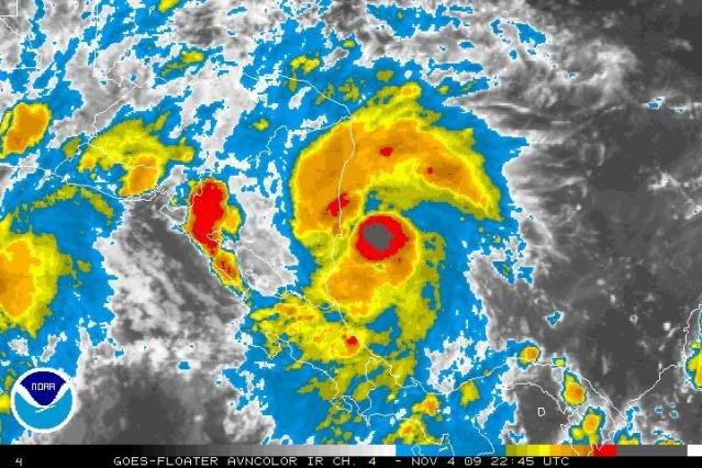
TROPICAL STORM IDA INTERMEDIATE ADVISORY NUMBER 2A
NWS TPC/NATIONAL HURRICANE CENTER MIAMI FL AL112009
700 PM EST WED NOV 04 2009
...IDA A LITTLE STRONGER AS IT HEADS TOWARD NICARAGUA...
A HURRICANE WATCH IS IN EFFECT FOR THE EASTERN COAST OF NICARAGUA
FROM BLUFIELDS NORTHWARD TO THE HONDURAS/NICARAGUA BORDER.
A HURRICANE WATCH MEANS THAT HURRICANE CONDITIONS ARE
POSSIBLE WITHIN THE WATCH AREA...GENERALLY WITHIN 36 HOURS.
A TROPICAL STORM WARNING REMAINS IN EFFECT FOR THE ENTIRE EASTERN
COAST OF NICARAGUA AND FOR THE ISLANDS OF SAN ANDRES AND
PROVIDENCIA.
A TROPICAL STORM WARNING MEANS THAT TROPICAL STORM CONDITIONS ARE
EXPECTED SOMEWHERE WITHIN THE WARNING AREA WITHIN 24 HOURS.
FOR STORM INFORMATION SPECIFIC TO YOUR AREA...PLEASE MONITOR
PRODUCTS ISSUED BY YOUR NATIONAL METEOROLOGICAL SERVICE.
AT 700 PM EST...0000 UTC...THE CENTER OF TROPICAL STORM IDA WAS
LOCATED NEAR LATITUDE 12.2 NORTH...LONGITUDE 82.9 WEST OR ABOUT 65
MILES...100 KM...EAST OF BLUEFIELDS NICARAGUA.
IDA IS MOVING TOWARD THE WEST-NORTHWEST NEAR 6 MPH...9 KM/HR. A
TURN TOWARD THE NORTHWEST WITH A DECREASE IN FORWARD SPEED IS
EXPECTED OVER THE NEXT COUPLE OF DAYS. ON THE FORECAST TRACK...IDA
SHOULD MAKE LANDFALL ALONG THE EAST COAST OF NICARAGUA EARLY
THURSDAY.
MAXIMUM SUSTAINED WINDS HAVE INCREASED TO NEAR 65 MPH...100 KM/HR...
WITH HIGHER GUSTS. ADDITIONAL STRENGTHENING IS POSSIBLE...AND IDA
COULD APPROACH HURRICANE INTENSITY BEFORE MAKING LANDFALL.
TROPICAL STORM FORCE WINDS EXTEND OUTWARD UP TO 45 MILES...75 KM
FROM THE CENTER.
THE ESTIMATED MINIMUM CENTRAL PRESSURE IS 996 MB...29.41 INCHES.
IDA IS EXPECTED TO PRODUCE TOTAL RAINFALL ACCUMULATIONS OF 5 TO 7
INCHES OVER SAN ANDRES ISLAND WITH MAXIMUM AMOUNTS OF 12 INCHES
POSSIBLE. RAINFALL ACCUMULATIONS OF 15 TO 20 INCHES ARE EXPECTED
OVER EASTERN NICARAGUA AND EASTERN HONDURAS WITH MAXIMUM AMOUNTS OF
25 INCHES POSSIBLE. THESE RAINS COULD PRODUCE LIFE-THREATENING
FLASH FLOOD AND MUD SLIDES.
...SUMMARY OF 700 PM EST INFORMATION...
LOCATION...12.2N 82.9W
MAXIMUM SUSTAINED WINDS...65 MPH
PRESENT MOVEMENT...WEST-NORTHWEST OR 300 DEGREES AT 6 MPH
MINIMUM CENTRAL PRESSURE...996 MB
THE NEXT ADVISORY WILL BE ISSUED BY THE NATIONAL
HURRICANE CENTER AT 1000 PM EST.
$$
FORECASTER PASCH/ROBERTS
WTNT31 KNHC 042342
TCPAT1
BULLETIN
TROPICAL STORM IDA INTERMEDIATE ADVISORY NUMBER 2A
NWS TPC/NATIONAL HURRICANE CENTER MIAMI FL AL112009
700 PM EST WED NOV 04 2009
...IDA A LITTLE STRONGER AS IT HEADS TOWARD NICARAGUA...
A HURRICANE WATCH IS IN EFFECT FOR THE EASTERN COAST OF NICARAGUA
FROM BLUFIELDS NORTHWARD TO THE HONDURAS/NICARAGUA BORDER.
A HURRICANE WATCH MEANS THAT HURRICANE CONDITIONS ARE
POSSIBLE WITHIN THE WATCH AREA...GENERALLY WITHIN 36 HOURS.
A TROPICAL STORM WARNING REMAINS IN EFFECT FOR THE ENTIRE EASTERN
COAST OF NICARAGUA AND FOR THE ISLANDS OF SAN ANDRES AND
PROVIDENCIA.
A TROPICAL STORM WARNING MEANS THAT TROPICAL STORM CONDITIONS ARE
EXPECTED SOMEWHERE WITHIN THE WARNING AREA WITHIN 24 HOURS.
FOR STORM INFORMATION SPECIFIC TO YOUR AREA...PLEASE MONITOR
PRODUCTS ISSUED BY YOUR NATIONAL METEOROLOGICAL SERVICE.
AT 700 PM EST...0000 UTC...THE CENTER OF TROPICAL STORM IDA WAS
LOCATED NEAR LATITUDE 12.2 NORTH...LONGITUDE 82.9 WEST OR ABOUT 65
MILES...100 KM...EAST OF BLUEFIELDS NICARAGUA.
IDA IS MOVING TOWARD THE WEST-NORTHWEST NEAR 6 MPH...9 KM/HR. A
TURN TOWARD THE NORTHWEST WITH A DECREASE IN FORWARD SPEED IS
EXPECTED OVER THE NEXT COUPLE OF DAYS. ON THE FORECAST TRACK...IDA
SHOULD MAKE LANDFALL ALONG THE EAST COAST OF NICARAGUA EARLY
THURSDAY.
MAXIMUM SUSTAINED WINDS HAVE INCREASED TO NEAR 65 MPH...100 KM/HR...
WITH HIGHER GUSTS. ADDITIONAL STRENGTHENING IS POSSIBLE...AND IDA
COULD APPROACH HURRICANE INTENSITY BEFORE MAKING LANDFALL.
TROPICAL STORM FORCE WINDS EXTEND OUTWARD UP TO 45 MILES...75 KM
FROM THE CENTER.
THE ESTIMATED MINIMUM CENTRAL PRESSURE IS 996 MB...29.41 INCHES.
IDA IS EXPECTED TO PRODUCE TOTAL RAINFALL ACCUMULATIONS OF 5 TO 7
INCHES OVER SAN ANDRES ISLAND WITH MAXIMUM AMOUNTS OF 12 INCHES
POSSIBLE. RAINFALL ACCUMULATIONS OF 15 TO 20 INCHES ARE EXPECTED
OVER EASTERN NICARAGUA AND EASTERN HONDURAS WITH MAXIMUM AMOUNTS OF
25 INCHES POSSIBLE. THESE RAINS COULD PRODUCE LIFE-THREATENING
FLASH FLOOD AND MUD SLIDES.
...SUMMARY OF 700 PM EST INFORMATION...
LOCATION...12.2N 82.9W
MAXIMUM SUSTAINED WINDS...65 MPH
PRESENT MOVEMENT...WEST-NORTHWEST OR 300 DEGREES AT 6 MPH
MINIMUM CENTRAL PRESSURE...996 MB
THE NEXT ADVISORY WILL BE ISSUED BY THE NATIONAL
HURRICANE CENTER AT 1000 PM EST.
$$
FORECASTER PASCH/ROBERTS
0 likes
Visit the Caribbean-Central America Weather Thread where you can find at first post web cams,radars
and observations from Caribbean basin members Click Here
and observations from Caribbean basin members Click Here
-
Derek Ortt
-
cycloneye
- Admin
- Posts: 149836
- Age: 69
- Joined: Thu Oct 10, 2002 10:54 am
- Location: San Juan, Puerto Rico
Re: ATL : TROPICAL STORM IDA
...SUMMARY OF 700 PM EST INFORMATION...
LOCATION...12.2N 82.9W
MAXIMUM SUSTAINED WINDS...65 MPH
PRESENT MOVEMENT...WEST-NORTHWEST OR 300 DEGREES AT 6 MPH
MINIMUM CENTRAL PRESSURE...996 MB
LOCATION...12.2N 82.9W
MAXIMUM SUSTAINED WINDS...65 MPH
PRESENT MOVEMENT...WEST-NORTHWEST OR 300 DEGREES AT 6 MPH
MINIMUM CENTRAL PRESSURE...996 MB
0 likes
Visit the Caribbean-Central America Weather Thread where you can find at first post web cams,radars
and observations from Caribbean basin members Click Here
and observations from Caribbean basin members Click Here
-
jlauderdal
- S2K Supporter

- Posts: 7240
- Joined: Wed May 19, 2004 5:46 am
- Location: NE Fort Lauderdale
- Contact:
Re: Re:
Sanibel wrote:gatorcane wrote:The 18Z GFDL goes crazy with Ida taking it to major hurricanes strength in the NW Caribbean south of Western tip of Cuba...with winds of 140 knots.
Ignore GFDL. It's on probation this year. Only use it with storms with an eye.
cat 2 or higher for gfdl, quite frankly the way it has been going this year im not trusting anything beyond 12 hours, im not even bringing out the angry koala bear yet, once it gets beyond any possible chance of hitting central america than koala comes out and not before and if that takes a week to move that far than so be it, no koala before its time. I don't care about models and forecasts, when and if it ever clears that land mass than he comes out otherwise its back to winter hibernation where he was enjoying his sleep.
0 likes
-
Dean4Storms
- S2K Supporter
- Posts: 6358
- Age: 63
- Joined: Sun Aug 31, 2003 1:01 pm
- Location: Miramar Bch. FL
-
Ivanhater
- Storm2k Moderator
- Posts: 11222
- Age: 39
- Joined: Fri Jul 01, 2005 8:25 am
- Location: Pensacola
Re: ATL : TROPICAL STORM IDA - Models
The water depth potential still supports a cat 5 I believe
0 likes
Michael
Re: ATL : TROPICAL STORM IDA - Models
GFS loops it right over the Loop Current:
http://moe.met.fsu.edu/cgi-bin/gfstc2.cgi?time=2009110418&field=Sea+Level+Pressure&hour=Animation
http://moe.met.fsu.edu/cgi-bin/gfstc2.cgi?time=2009110418&field=Sea+Level+Pressure&hour=Animation
0 likes
-
cycloneye
- Admin
- Posts: 149836
- Age: 69
- Joined: Thu Oct 10, 2002 10:54 am
- Location: San Juan, Puerto Rico
Re: ATL : TROPICAL STORM IDA - Models
18z HWRF follows the NHC track,no cat 5 here.
http://moe.met.fsu.edu/cgi-bin/hwrftc2. ... =Animation
http://moe.met.fsu.edu/cgi-bin/hwrftc2. ... =Animation
0 likes
Visit the Caribbean-Central America Weather Thread where you can find at first post web cams,radars
and observations from Caribbean basin members Click Here
and observations from Caribbean basin members Click Here
-
dixiebreeze
- S2K Supporter
- Posts: 5140
- Joined: Wed Sep 03, 2003 5:07 pm
- Location: crystal river, fla.
-
Ivanhater
- Storm2k Moderator
- Posts: 11222
- Age: 39
- Joined: Fri Jul 01, 2005 8:25 am
- Location: Pensacola
Re: ATL : TROPICAL STORM IDA

A lot of the models are keeping Ida offshore, something to watch for
0 likes
Michael
-
CrazyC83
- Professional-Met

- Posts: 34316
- Joined: Tue Mar 07, 2006 11:57 pm
- Location: Deep South, for the first time!
Re:
Derek Ortt wrote:cat 5 into Cuba... didnt think we'd see that solution. Then again, I didnt think we'd see this RI today
It happened in 1932 (most likely), so it isn't unheard-of...
0 likes


Re: ATL : TROPICAL STORM IDA - Models
cycloneye wrote:18z HWRF follows the NHC track,no cat 5 here.
http://moe.met.fsu.edu/cgi-bin/hwrftc2. ... =Animation
That would be a heck of a flood for the South as the cold front would pick up the entire GOM and dump it...wet footballs for everyone
0 likes
-
ozonepete
- Professional-Met
- Posts: 4743
- Joined: Mon Sep 07, 2009 3:23 pm
- Location: From Ozone Park, NYC / Now in Brooklyn, NY
Re: ATL : TROPICAL STORM IDA
Now it looks like it might just ride up along the coast or just inland on a more NNW track. I've seen tropical cyclones do this before. The physics/aerodynamics is pretty logical. The front left quadrant is abutting those tall mountains from south to north and so the flow to the west is getting blocked from low to mid-levels. The Radius of Maximum Winds (the core) then begins to follow the path of least resistance, in this case more northward.
0 likes
Who is online
Users browsing this forum: No registered users and 67 guests