Interestingly, NHC has estimated the pressure has dropped 6 hPa in the last 12 hours...
AL, 92, 2009060200, , BEST, 0, 408N, 242W, 35, 1001, LO, 34, NEQ, 50, 50, 0, 0, 1010, 240, 35, 0, 0, L, 0, , 0, 0, INVEST, D,
AL, 92, 2009060206, , BEST, 0, 417N, 237W, 40, 999, LO, 34, NEQ, 50, 50, 0, 0,
AL, 92, 2009060212, , BEST, 0, 428N, 237W, 45, 995, LO, 34, NEQ, 60, 60, 0, 0, 1012, 300, 30, 0, 0, L, 0, , 0, 0, INVEST, D,
NE of Azores Islands : INVEST 92L
Moderator: S2k Moderators
-
cycloneye

- Admin

- Posts: 149807
- Age: 69
- Joined: Thu Oct 10, 2002 10:54 am
- Location: San Juan, Puerto Rico
Re: NE of Azores Islands : INVEST 92L
IMO,I dont think a models thread is needed in this case because this will go soon,so we can post any model information in here.
WHXX01 KWBC 021315
CHGHUR
TROPICAL CYCLONE GUIDANCE MESSAGE
NWS TPC/NATIONAL HURRICANE CENTER MIAMI FL
1315 UTC TUE JUN 2 2009
DISCLAIMER...NUMERICAL MODELS ARE SUBJECT TO LARGE ERRORS.
PLEASE REFER TO NHC OFFICIAL FORECASTS FOR TROPICAL CYCLONE
AND SUBTROPICAL CYCLONE INFORMATION.
ATLANTIC OBJECTIVE AIDS FOR
DISTURBANCE INVEST (AL922009) 20090602 1200 UTC
...00 HRS... ...12 HRS... ...24 HRS. .. ...36 HRS...
090602 1200 090603 0000 090603 1200 090604 0000
LAT LON LAT LON LAT LON LAT LON
BAMS 42.8N 23.7W 44.3N 23.7W 45.3N 24.2W 45.8N 24.7W
BAMD 42.8N 23.7W 44.5N 24.1W 45.2N 24.9W 44.6N 24.4W
BAMM 42.8N 23.7W 44.4N 24.0W 45.3N 24.7W 45.2N 24.6W
LBAR 42.8N 23.7W 45.1N 23.8W 47.2N 26.0W 48.1N 27.7W
...48 HRS... ...72 HRS... ...96 HRS. .. ..120 HRS...
090604 1200 090605 1200 090606 1200 090607 1200
LAT LON LAT LON LAT LON LAT LON
BAMS 45.5N 24.3W 43.3N 19.6W 39.5N 11.7W 37.7N 4.4W
BAMD 42.7N 21.2W 40.1N 8.0W 45.0N 7.4E 50.4N 23.3E
BAMM 44.0N 22.7W 41.0N 13.1W 42.7N .5W 46.7N 9.9E
LBAR 48.9N 27.0W 54.2N 28.7W 46.4N 18.1W 42.9N 5.5W
...INITIAL CONDITIONS...
LATCUR = 42.8N LONCUR = 23.7W DIRCUR = 15DEG SPDCUR = 9KT
LATM12 = 40.8N LONM12 = 24.2W DIRM12 = 25DEG SPDM12 = 9KT
LATM24 = 39.2N LONM24 = 25.5W
WNDCUR = 45KT RMAXWD = 30NM WNDM12 = 35KT
CENPRS = 995MB OUTPRS = 1012MB OUTRAD = 300NM SDEPTH = D
RD34NE = 60NM RD34SE = 60NM RD34SW = 0NM RD34NW = 0NM
0 likes
-
DanieleItalyRm
- Category 1

- Posts: 487
- Age: 40
- Joined: Mon Sep 22, 2008 7:52 am
- Location: Rome - Italy - Mediterranean sea
-
wxman57

- Moderator-Pro Met

- Posts: 23176
- Age: 68
- Joined: Sat Jun 21, 2003 8:06 pm
- Location: Houston, TX (southwest)
Re: NE of Azores Islands : INVEST 92L
No question it's a big low pressure system with 35-45 kt winds. But it's over SSTs in the upper 50s now (and dropping). Nothing tropical about it in the least. Let's hope the NHC doesn't waste a name on a cold core winter-type low pressure area.
0 likes
-
senorpepr

- Military Met/Moderator

- Posts: 12542
- Age: 43
- Joined: Fri Aug 22, 2003 9:22 pm
- Location: Mackenbach, Germany
- Contact:
Re: NE of Azores Islands : INVEST 92L
Here's the 02/12Z analysis from the USAF / 21 OWS
UK Met Guidance shows slow progression toward the UK through the next four days.

UK Met Guidance shows slow progression toward the UK through the next four days.
0 likes
-
DanieleItalyRm
- Category 1
- Posts: 487
- Age: 40
- Joined: Mon Sep 22, 2008 7:52 am
- Location: Rome - Italy - Mediterranean sea
Re: NE of Azores Islands : INVEST 92L
wxman57 wrote:Let's hope the NHC doesn't waste a name on a cold core winter-type low pressure area.
A cold core winter-type low pressure area?
Many anomaly north Atlantic tropical cyclones some degrees below temperatures when Karl, Charly, Epsilon, Zeta, Vince etc. and derived from a non tropical low, cut off or cold core cyclones..
K.Emanuel " cut off cold core is an ideal embryon in wich a tropical like cyclones can be produced"..
These phenomeno occured in Mediterranean sea,but on warmer whaters.
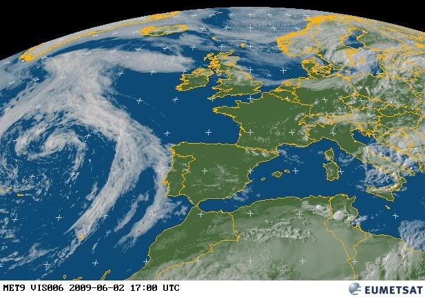
12 UTC:


and not cold core.. it's warm core:

Last edited by DanieleItalyRm on Tue Jun 02, 2009 9:46 am, edited 1 time in total.
0 likes
-
littlevince

- S2K Supporter

- Posts: 768
- Joined: Fri Oct 21, 2005 10:45 am
- Location: Portugal
Re: NE of Azores Islands : INVEST 92L
wxman57 wrote:Let's hope the NHC doesn't waste a name on a cold core winter-type low pressure area.
Hi wxman57. Although I agree that probably is a waste using a name on this and you are my preferred user in this board
If GFS has a vertical profile of temperature with a warm zone over the center in almost all layers of the atmosphere (till 450hPa) why should this be a cold core ?

Is this a absolute wrong approach to detect a possible warm core ? I know models are not reality, unfortunately CIMSS Advanced Microwave Sounding Unit is still not available to this system to confirm a warm core.
0 likes


-
wxman57
- Moderator-Pro Met
- Posts: 23176
- Age: 68
- Joined: Sat Jun 21, 2003 8:06 pm
- Location: Houston, TX (southwest)
Re: NE of Azores Islands : INVEST 92L
Phase diagram says cold core today. Models hint at nearing warm core tomorrow before becoming symmetric cold core on Thursday. Nothing worth naming.
http://moe.met.fsu.edu/cyclonephase/cmc ... 00/11.html
http://moe.met.fsu.edu/cyclonephase/cmc ... 00/11.html
0 likes
-
hurricanefloyd5

- Category 5

- Posts: 1659
- Age: 45
- Joined: Sun May 02, 2004 10:53 am
- Location: Spartanburg
- Contact:
-
DanieleItalyRm
- Category 1
- Posts: 487
- Age: 40
- Joined: Mon Sep 22, 2008 7:52 am
- Location: Rome - Italy - Mediterranean sea


-
JonathanBelles
- Professional-Met

- Posts: 11430
- Age: 35
- Joined: Sat Dec 24, 2005 9:00 pm
- Location: School: Florida State University (Tallahassee, FL) Home: St. Petersburg, Florida
- Contact:
-
HURAKAN

- Professional-Met
- Posts: 46084
- Age: 39
- Joined: Thu May 20, 2004 4:34 pm
- Location: Key West, FL
- Contact:
Re: NE of Azores Islands : INVEST 92L
235
ABNT20 KNHC 021733
TWOAT
TROPICAL WEATHER OUTLOOK
NWS TPC/NATIONAL HURRICANE CENTER MIAMI FL
200 PM EDT TUE JUN 2 2009
FOR THE NORTH ATLANTIC...CARIBBEAN SEA AND THE GULF OF MEXICO...
SATELLITE AND MICROWAVE OBSERVATIONS INDICATE THAT THE AREA OF LOW
PRESSURE LOCATED ABOUT 400 MILES NORTH-NORTHEAST OF THE AZORES
ISLANDS HAS ACQUIRED SOME TROPICAL CHARACTERISTICS. HOWEVER...THIS
SYSTEM IS MOVING TO THE NORTH-NORTHWEST AT ABOUT 10 MPH OVER
INCREASINGLY COOLER WATERS AND FURTHER DEVELOPMENT...IF
ANY...SHOULD BE SLOW TO OCCUR. THERE IS A LOW CHANCE...LESS THAN
30 PERCENT...OF THIS SYSTEM BECOMING A TROPICAL OR SUBTROPICAL
CYCLONE DURING THE NEXT 48 HOURS.
ELSEWHERE...TROPICAL CYCLONE FORMATION IS NOT EXPECTED DURING THE
NEXT 48 HOURS.
$$
FORECASTER BLAKE
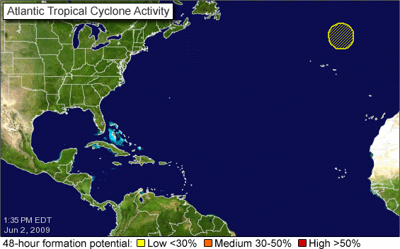
The circle keeps going north!!!
ABNT20 KNHC 021733
TWOAT
TROPICAL WEATHER OUTLOOK
NWS TPC/NATIONAL HURRICANE CENTER MIAMI FL
200 PM EDT TUE JUN 2 2009
FOR THE NORTH ATLANTIC...CARIBBEAN SEA AND THE GULF OF MEXICO...
SATELLITE AND MICROWAVE OBSERVATIONS INDICATE THAT THE AREA OF LOW
PRESSURE LOCATED ABOUT 400 MILES NORTH-NORTHEAST OF THE AZORES
ISLANDS HAS ACQUIRED SOME TROPICAL CHARACTERISTICS. HOWEVER...THIS
SYSTEM IS MOVING TO THE NORTH-NORTHWEST AT ABOUT 10 MPH OVER
INCREASINGLY COOLER WATERS AND FURTHER DEVELOPMENT...IF
ANY...SHOULD BE SLOW TO OCCUR. THERE IS A LOW CHANCE...LESS THAN
30 PERCENT...OF THIS SYSTEM BECOMING A TROPICAL OR SUBTROPICAL
CYCLONE DURING THE NEXT 48 HOURS.
ELSEWHERE...TROPICAL CYCLONE FORMATION IS NOT EXPECTED DURING THE
NEXT 48 HOURS.
$$
FORECASTER BLAKE
The circle keeps going north!!!
0 likes
-
cycloneye
- Admin
- Posts: 149807
- Age: 69
- Joined: Thu Oct 10, 2002 10:54 am
- Location: San Juan, Puerto Rico
Re: NE of Azores Islands : INVEST 92L
The 12 UTC surface analysis shows the pressure dropping a bit more now at 994 mbs

0 likes

-
hurricanefloyd5
- Category 5
- Posts: 1659
- Age: 45
- Joined: Sun May 02, 2004 10:53 am
- Location: Spartanburg
- Contact:
Who is online
Users browsing this forum: No registered users and 31 guests