ATL : TROPICAL DEPRESSION IDA
Moderator: S2k Moderators
-
cycloneye

- Admin

- Posts: 149839
- Age: 69
- Joined: Thu Oct 10, 2002 10:54 am
- Location: San Juan, Puerto Rico
Re: ATL : TROPICAL STORM IDA - Models
IMO,GFDL and HWRF the stellars for Ida without question.
0 likes
Visit the Caribbean-Central America Weather Thread where you can find at first post web cams,radars
and observations from Caribbean basin members Click Here
and observations from Caribbean basin members Click Here
-
srainhoutx

- S2K Supporter

- Posts: 6919
- Age: 68
- Joined: Sun Jan 14, 2007 11:34 am
- Location: Haywood County, NC
- Contact:
Re: ATL : TROPICAL STORM IDA
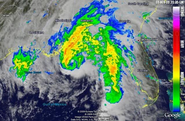
I am impressed with the tenacity of Ida. Convection firing yet again...
http://www.ssd.noaa.gov/goes/flt/t2/flash-avn.html
http://www.ssd.noaa.gov/goes/flt/t2/flash-avn.html
0 likes
Carla/Alicia/Jerry(In The Eye)/Michelle/Charley/Ivan/Dennis/Katrina/Rita/Wilma/Ike/Harvey
Member: National Weather Association
Wx Infinity Forums
http://wxinfinity.com/index.php
Facebook.com/WeatherInfinity
Twitter @WeatherInfinity
Member: National Weather Association
Wx Infinity Forums
http://wxinfinity.com/index.php
Facebook.com/WeatherInfinity
Twitter @WeatherInfinity
Re: ATL : TROPICAL STORM IDA
I'd have to give the nod to hurricane at 991 pressure.
Still just west of north in track.
Still just west of north in track.
Last edited by Sanibel on Mon Nov 09, 2009 3:29 pm, edited 1 time in total.
0 likes
-
ozonepete
- Professional-Met

- Posts: 4743
- Joined: Mon Sep 07, 2009 3:23 pm
- Location: From Ozone Park, NYC / Now in Brooklyn, NY
Re: ATL : TROPICAL STORM IDA
srainhoutx wrote:I am impressed with the tenacity of Ida. Convection firing yet again...
http://www.ssd.noaa.gov/goes/flt/t2/flash-avn.html
Yes it's very impressive for a November cyclone at this latitude. Even though some ET has started, I would still call it more tropical cyclone than not by far, based on recon and the satellite images.
0 likes

-
Aric Dunn
- Category 5

- Posts: 21238
- Age: 43
- Joined: Sun Sep 19, 2004 9:58 pm
- Location: Ready for the Chase.
- Contact:
Re: ATL : TROPICAL STORM IDA
ozonepete wrote:srainhoutx wrote:I am impressed with the tenacity of Ida. Convection firing yet again...
http://www.ssd.noaa.gov/goes/flt/t2/flash-avn.html
Yes it's very impressive for a November cyclone at this latitude. Even though some ET has started, I would still call it more tropical cyclone than not by far, based on recon and the satellite images.
not too much .. the tail does not make it ET
the temp and dew points still point to tropical ..
0 likes
-
cycloneye
- Admin
- Posts: 149839
- Age: 69
- Joined: Thu Oct 10, 2002 10:54 am
- Location: San Juan, Puerto Rico
Re: ATL : TROPICAL STORM IDA - Recon
URNT15 KNHC 092028
AF303 0711A IDA HDOB 25 20091109
202030 2651N 08856W 8432 01536 0067 +165 +116 276029 029 026 000 03
202100 2652N 08854W 8430 01538 0067 +165 +115 275029 030 024 000 03
202130 2652N 08852W 8429 01538 0066 +165 +116 274030 031 022 000 00
202200 2653N 08850W 8430 01536 0065 +165 +116 272032 033 023 000 00
202230 2653N 08848W 8430 01535 0064 +165 +115 274032 033 022 000 00
202300 2653N 08846W 8429 01537 0063 +165 +116 272032 033 021 000 00
202330 2654N 08844W 8429 01535 0064 +163 +119 270031 032 022 000 00
202400 2654N 08842W 8431 01533 0064 +160 +120 269031 031 023 000 03
202430 2654N 08839W 8429 01534 0066 +159 +124 266030 030 022 000 00
202500 2655N 08837W 8430 01534 0064 +161 +122 267032 033 025 000 00
202530 2655N 08835W 8431 01533 0065 +159 +125 264031 032 025 000 00
202600 2656N 08833W 8426 01539 0065 +159 +126 262031 033 024 000 03
202630 2656N 08831W 8430 01535 0071 +149 +137 248029 029 024 000 03
202700 2656N 08829W 8429 01536 0072 +147 +140 242029 029 022 000 03
202730 2657N 08827W 8429 01536 0072 +148 +141 239030 030 020 000 00
202800 2657N 08825W 8426 01538 0072 +147 +140 240030 030 021 000 00
202830 2657N 08823W 8430 01534 0072 +148 +139 239029 030 022 000 03
202900 2658N 08821W 8430 01535 0073 +145 +140 235029 029 021 000 00
202930 2658N 08819W 8429 01535 0073 +145 +139 237029 029 026 000 00
203000 2659N 08817W 8431 01534 0073 +145 +139 236029 030 026 001 00
0 likes
Visit the Caribbean-Central America Weather Thread where you can find at first post web cams,radars
and observations from Caribbean basin members Click Here
and observations from Caribbean basin members Click Here
Re: ATL : TROPICAL STORM IDA
Aric Dunn wrote:the temp and dew points still point to tropical ..
So does the general shape.
It's managed to keep that nasty little RI core it had ever since Nicaragua.
0 likes
-
wxman57

- Moderator-Pro Met

- Posts: 23177
- Age: 68
- Joined: Sat Jun 21, 2003 8:06 pm
- Location: Houston, TX (southwest)
Re: ATL : TROPICAL STORM IDA
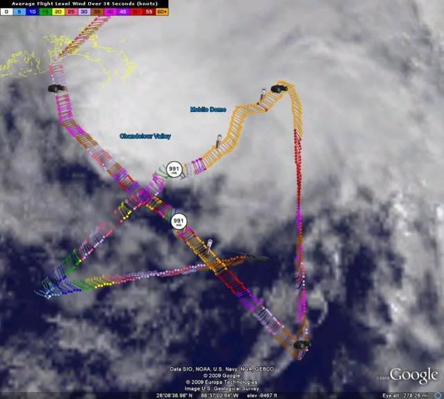
Ivanhater wrote:Eye seems to be tightening on the Mobile radar.
Just remember you're looking at Ida's center at a height of 25,000 feet at that distance. We'll see more detail when Ida gets closer to the radar and we can see a bit closer to the surface.
Here's my handy-dandy radar beam height calculator link:
http://www.wdtb.noaa.gov/tools/misc/bea ... width.html
0 likes


Looks the NHC and others were right to call for a hurricane even if it is not upgraded here at the end. Those calling for extratropical transition before landfall will have to put on a pair of sad pants, a silly hat, a failure scarf and eat crow as Ida has pwned them and made them look foolish. 
0 likes
-
cycloneye
- Admin
- Posts: 149839
- Age: 69
- Joined: Thu Oct 10, 2002 10:54 am
- Location: San Juan, Puerto Rico
Re: ATL : TROPICAL STORM IDA - Recon
URNT15 KNHC 092038
AF303 0711A IDA HDOB 26 20091109
203030 2659N 08815W 8431 01533 0073 +145 +141 232030 031 028 000 00
203100 2659N 08813W 8429 01534 0072 +143 +143 231033 034 028 000 00
203130 2700N 08811W 8432 01532 0073 +141 +141 231033 034 029 000 00
203200 2700N 08809W 8428 01537 0074 +140 +140 233031 032 029 000 00
203230 2700N 08807W 8430 01536 0074 +142 +140 234032 035 028 000 00
203300 2701N 08804W 8429 01536 0071 +146 +143 234036 037 028 000 00
203330 2701N 08802W 8429 01536 0070 +150 +143 233037 038 026 000 00
203400 2702N 08800W 8429 01535 0069 +150 +142 232038 038 026 000 00
203430 2702N 08758W 8430 01534 0068 +150 +142 231038 038 026 000 00
203500 2702N 08756W 8430 01536 0072 +150 +142 228036 036 025 000 00
203530 2703N 08754W 8430 01537 0071 +146 +142 230035 036 026 000 03
203600 2703N 08752W 8431 01534 0072 +145 +141 233035 036 027 000 03
203630 2703N 08750W 8430 01536 0073 +146 +140 228035 035 028 000 00
203700 2704N 08748W 8430 01536 0073 +147 +141 227036 036 028 000 00
203730 2704N 08746W 8430 01537 0072 +153 +140 227036 037 030 000 03
203800 2705N 08744W 8429 01539 0074 +148 +142 226038 038 029 000 03
203830 2705N 08741W 8432 01539 0073 +154 +140 223039 039 031 000 00
203900 2705N 08739W 8429 01540 0067 +166 +133 225037 039 030 000 00
203930 2706N 08737W 8429 01540 0065 +170 +129 226037 037 030 000 00
204000 2706N 08735W 8430 01541 0064 +174 +124 228038 038 030 000 00
0 likes
Visit the Caribbean-Central America Weather Thread where you can find at first post web cams,radars
and observations from Caribbean basin members Click Here
and observations from Caribbean basin members Click Here
Re: ATL : TROPICAL STORM IDA
Edit: Mobile long range radar back up.
Core should miss New Orleans.
Core should miss New Orleans.
The posts in this forum are NOT official forecast and should not be used as such. They are just the opinion of the poster and may or may not be backed by sound meteorological data. They are NOT endorsed by any professional institution or storm2k.org. For official information, please refer to the NHC and NWS products.
Last edited by Sanibel on Mon Nov 09, 2009 3:48 pm, edited 1 time in total.
0 likes
-
AJC3

- Admin
- Posts: 4156
- Age: 62
- Joined: Tue Aug 31, 2004 7:04 pm
- Location: Ballston Spa, New York
- Contact:
Re: ATL : TROPICAL STORM IDA
Sanibel wrote:As usual NWS radar fails just when you need it.
Just to be clear, the Mobile radar is up. I think the short range products are getting accessed so much that it's hammering the server. The long range BREF product is still available though...
http://radar.weather.gov/radar.php?rid= ... 1&loop=yes
0 likes

Re: ATL : TROPICAL STORM IDA
srainhoutx wrote:I am impressed with the tenacity of Ida. Convection firing yet again...
http://www.ssd.noaa.gov/goes/flt/t2/flash-avn.html
and she is doing this over sub 80F water. SST's cant be much more that 73F in that area....she is a fighter to the very end. Also think land interaction is helping her tighten up her core some.
0 likes
-
cycloneye
- Admin
- Posts: 149839
- Age: 69
- Joined: Thu Oct 10, 2002 10:54 am
- Location: San Juan, Puerto Rico
Re: ATL : TROPICAL STORM IDA - Recon
RECCO OBSERVATION
Product: Air Force Tropical RECCO Message (URNT11 KNHC)
Transmitted: 9th day of the month at 20:44Z
Aircraft: Air Force Aircraft (Last 3 digits of the tail number are 303)
Storm Number: 11
Storm Name: Ida (flight in the North Atlantic basin)
Mission Number: 7
Observation Number: 13
Observation Time: Monday, 20:44Z
Radar Capability: Yes
Aircraft Altitude: Below 10,000 meters
Coordinates: 27.2N 87.3W
Location: 224 miles (360 km) to the S (181°) from Pensacola, FL, USA.
Turbulence: None
Conditions Along Flight Route: In the clear
Pressure Altitude: 1,530 meters
Flight Level Wind: From 210° at 41 knots (From the SSW at ~ 47.1 mph)
- The above is a spot wind.
- Winds were obtained using doppler radar or inertial systems.
Flight Level Temperature: 17°C
Flight Level Dew Point: 14°C
Weather (within 30 nautical miles): Broken clouds (5/8 to 7/8 cloud coverage)
850 mb Surface Altitude: 1,479 geopotential meters
0 likes
Visit the Caribbean-Central America Weather Thread where you can find at first post web cams,radars
and observations from Caribbean basin members Click Here
and observations from Caribbean basin members Click Here
-
Aric Dunn
- Category 5
- Posts: 21238
- Age: 43
- Joined: Sun Sep 19, 2004 9:58 pm
- Location: Ready for the Chase.
- Contact:
Re: ATL : TROPICAL STORM IDA
AJC3 wrote:Sanibel wrote:As usual NWS radar fails just when you need it.
Just to be clear, the Mobile radar is up. I think the short range products are getting accessed so much that it's hammering the server. The long range BREF product is still available though...
http://radar.weather.gov/radar.php?rid= ... 1&loop=yes
my Grlevel Analyst has been working fine
0 likes
Who is online
Users browsing this forum: No registered users and 64 guests