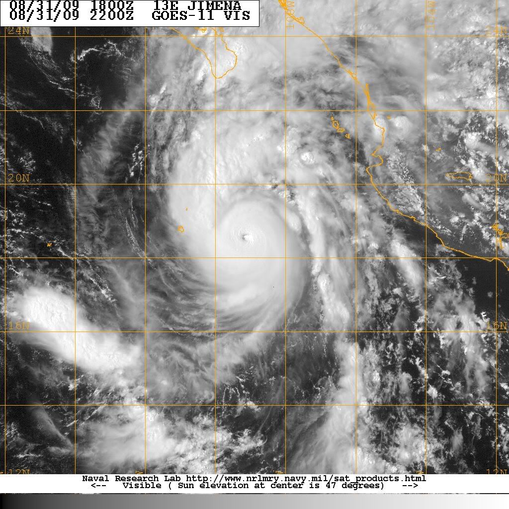
bombarderoazul wrote:It looks like the eye is becoming more circular. It seems to be gaining strength.
The next flight isn't until tomorrow afternoon, so they would need to make judgement calls until then on whether or not to upgrade.
Moderator: S2k Moderators

bombarderoazul wrote:It looks like the eye is becoming more circular. It seems to be gaining strength.
NHC Discussion 13 on Hurricane Jimena wrote:THE AIR FORCE RESERVE HURRICANE HUNTERS HAVE JUST COMPLETED THEIR
MISSION IN JIMENA...AND FOUND THAT THE HURRICANE WAS STRONGER THAN
PREVIOUSLY ESTIMATED. PEAK 700 MB FLIGHT-LEVEL WINDS WERE 149 KT
AND THE MAXIMUM SFMR-MEASURED SURFACE WINDS WERE 132 KT OVER THE
NORTHEAST QUADRANT. THE SFMR ALSO MEASURED 128 KT IN THE NORTHWEST
EYEWALL AND 125 KT IN THE SOUTHWEST PART OF THE EYEWALL. A MINIMUM
CENTRAL PRESSURE OF 931 MB WAS MEASURED BY DROPSONDE. THE CURRENT
INTENSITY IS ADJUSTED UPWARD TO 135 KT...AT THE VERY HIGH END OF
CATEGORY 4 STATUS.


srainhoutx wrote:
KBBOCA wrote:Wow! Jaw-dropping indeed!
Yet these are awesome to watch. I'm praying for all in this storm's path tonight and hope the storm will weaken or stay offshore enough to prevent terrible destruction or loss of life.
KBBOCA wrote:Wow! Jaw-dropping indeed!
And yet with a Cat4-Cat 5 hurricane about to hit a major resort area this thread is only at 18 pages?!? Although understandable, I always have to laugh when the slightest blob in the Atlantic generates dozens of pages of discussion and the monster storms in the Pacific go unnoticed by most...
Yet these are awesome to watch. I'm praying for all in this storm's path tonight and hope the storm will weaken or stay offshore enough to prevent terrible destruction or loss of life.
Cookie wrote:seem thing happens on a forum I use, hurricanes are tucked away in a small sub section.
all year round its just me and another guy, come the summer everyone piles in.
Cyclenall wrote:NHC Discussion 13 on Hurricane Jimena wrote:THE AIR FORCE RESERVE HURRICANE HUNTERS HAVE JUST COMPLETED THEIR
MISSION IN JIMENA...AND FOUND THAT THE HURRICANE WAS STRONGER THAN
PREVIOUSLY ESTIMATED. PEAK 700 MB FLIGHT-LEVEL WINDS WERE 149 KT
AND THE MAXIMUM SFMR-MEASURED SURFACE WINDS WERE 132 KT OVER THE
NORTHEAST QUADRANT. THE SFMR ALSO MEASURED 128 KT IN THE NORTHWEST
EYEWALL AND 125 KT IN THE SOUTHWEST PART OF THE EYEWALL. A MINIMUM
CENTRAL PRESSURE OF 931 MB WAS MEASURED BY DROPSONDE. THE CURRENT
INTENSITY IS ADJUSTED UPWARD TO 135 KT...AT THE VERY HIGH END OF
CATEGORY 4 STATUS.
What flight reduction method was used for the flight level winds?
One interesting thing about the track is if it were to unexpectedly go to the far left of the track cone and remain over water the whole time, Jimena would pay a visit to southern California in some form. It's at the perfect angle but it would have to be a bit faster beyond three days. I can see a big flooding problem at the end of the forecast period regardless of where it ends up.
The eye has been getting a little better defined within the past few hours.


KBBOCA wrote:Wow! Jaw-dropping indeed!
And yet with a Cat4-Cat 5 hurricane about to hit a major resort area this thread is only at 18 pages?!? Although understandable, I always have to laugh when the slightest blob in the Atlantic generates dozens of pages of discussion and the monster storms in the Pacific go unnoticed by most...
Yet these are awesome to watch. I'm praying for all in this storm's path tonight and hope the storm will weaken or stay offshore enough to prevent terrible destruction or loss of life.
Users browsing this forum: No registered users and 15 guests


