
ATL : INVEST 93L
Moderator: S2k Moderators


Re: ATL : INVEST 93L
Personal Forecast Disclaimer:
The posts in this forum are NOT official forecast and should not be used as such. They are just the opinion of the poster and may or may not be backed by sound meteorological data. They are NOT endorsed by any professional institution or storm2k.org. For official information, please refer to the NHC and NWS products.
Position where they started the 18z models look good to me, better than this mornings 12z positioning.
I can clearly see an elongated surface vorticity near the coast of the Yucatan Peninsula just SSW of Cozumel. I really doubt that it will have time to get together over the next 24 hrs as it tracks over land of course, so by the time reconn gets there tomorrow afternoon it would had just emerged or redeveloped north of the Peninsula, so it will probably be too weak to be at least a TD. I am thinking that it will spend some time in the south central gulf as the initial trough will miss it, Wednesday another troughs digs down closer to the MS valley so it will have a chance to start moving then towards western FL.
0 likes
-
caneman
Re: ATL : INVEST 93L
According to the current weather upday. They are showing West winds in Cancun:
http://www.wunderground.com/global/stations/76590.html
http://www.wunderground.com/global/stations/76590.html
0 likes
-
Aric Dunn
- Category 5

- Posts: 21238
- Age: 43
- Joined: Sun Sep 19, 2004 9:58 pm
- Location: Ready for the Chase.
- Contact:
Re: ATL : INVEST 93L
Thanks to senorpepr latest streams line are starting to show some for definition in the wind field..

Last edited by Aric Dunn on Sat Jun 27, 2009 2:50 pm, edited 1 time in total.
0 likes
-
Derek Ortt
-
Aric Dunn
- Category 5
- Posts: 21238
- Age: 43
- Joined: Sun Sep 19, 2004 9:58 pm
- Location: Ready for the Chase.
- Contact:
Re:
Derek Ortt wrote:we have a whole 2 mph out of the east. Winds that weak are likely local effects and not indicative of a circulation
yes. .thats true.. ( and im not saying there is one of course) but the winds must first stop before they can switch direction..
0 likes
-
Aric Dunn
- Category 5
- Posts: 21238
- Age: 43
- Joined: Sun Sep 19, 2004 9:58 pm
- Location: Ready for the Chase.
- Contact:
Re: ATL : INVEST 93L
Aric Dunn wrote:Thanks to senorpepr latest streams line are starting to show some for definition in the wind field..
just realized you have to open this a reload to see the new images.. lol
0 likes


-
wxman57

- Moderator-Pro Met

- Posts: 23177
- Age: 68
- Joined: Sat Jun 21, 2003 8:06 pm
- Location: Houston, TX (southwest)
Re: ATL : INVEST 93L
fci wrote:
I have to go with Dizzy on this.
I swear that I have heard (read on here) MANY times that the models meant nothing until a LLC developed.
I too will copy and paste this one so I can post it later when many claim that the models mean nothing until there is development to a LLC.
It all depends upon what models you're using and for what purpose (track/intensity). With this system, if the dynamic models (GFS/EC/CMC) are not developing it, then they'll do a fair job of predicting where the low-level vorticity will track. But if we take a look at intensity output from HWRF, for example, it has been developing 93L into a TS within 6 hours with each run, and up to a significant hurricane in the Gulf. This is because, as Derek said, the models (HWRF/GFDL/SHIP) must be initialized with a vortex for them to work. But if it's Just a phantom vortex (like 93L), then they'll be clueless about intensity.
Each situation (disturbance/tropical threat) is different. You can't make a blanket statement that the models are always bad or good with an invest. You have to look at all the variables. In this case, the models are not developing 93L and it's not likely to develop, so they'll do a fair job of predicting where the energy will go.
0 likes
-
Aric Dunn
- Category 5
- Posts: 21238
- Age: 43
- Joined: Sun Sep 19, 2004 9:58 pm
- Location: Ready for the Chase.
- Contact:
Re: ATL : INVEST 93L
18z
Low level convergence

And the 850 MB vort map showing increase vorticity along the coast right where we would expect it to be with the sharpening wave axis

Low level convergence
And the 850 MB vort map showing increase vorticity along the coast right where we would expect it to be with the sharpening wave axis
0 likes

-
cycloneye

- Admin

- Posts: 149829
- Age: 69
- Joined: Thu Oct 10, 2002 10:54 am
- Location: San Juan, Puerto Rico
Re: ATL : INVEST 93L
Will convection persist this time? In the last two nights it has waned.

0 likes
Re: ATL : INVEST 93L
The difference that today, IMO, we have a true surface convergence going on, the last couple of days this system's convection was nothing but UL divergence and outflow boundaries.
0 likes

Re: ATL : INVEST 93L
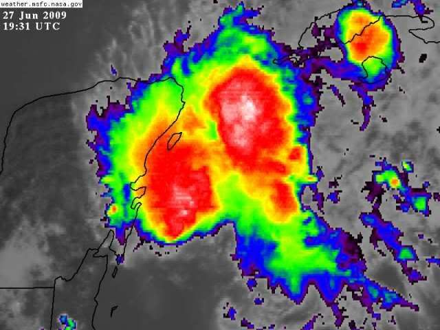
The wave is sharpening up a little but will be over or near land so a TD probably won't be declared till it gets out in the gulf. The convection is picking up again near the Axis of the wave and you can see some lower cloud movement in the wwwghcc.msfc.nasa.gov zoomed loop. Looks just like a classic sharpening wave.
Last edited by Nimbus on Sat Jun 27, 2009 3:17 pm, edited 1 time in total.
0 likes
-
Aric Dunn
- Category 5
- Posts: 21238
- Age: 43
- Joined: Sun Sep 19, 2004 9:58 pm
- Location: Ready for the Chase.
- Contact:
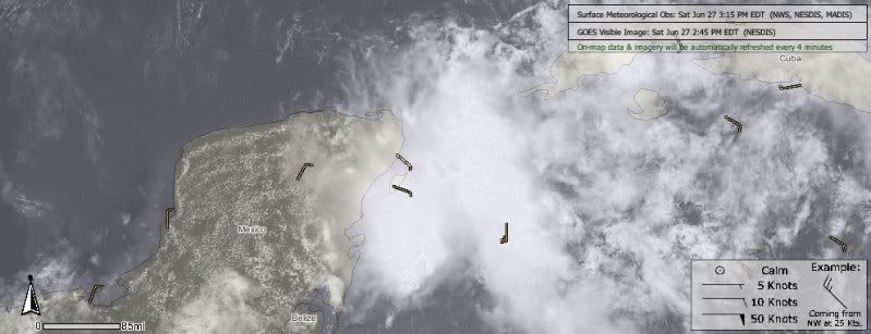
The position estimate seems to be right on.. there is clearly strong SSE inflow just off shore and then makes a hard left just south of Cozumel. surface low may start taking shape in this general area over night ... http://cimss.ssec.wisc.edu/tropic2/real ... 000&loop=0
0 likes
Who is online
Users browsing this forum: No registered users and 42 guests