WPAC : TROPICAL DEPRESSION PARMA (19W)

Moderator: S2k Moderators

Message
Author
ozonepete
Professional-Met
Professional-Met
Posts: 4743
Joined: Mon Sep 07, 2009 3:23 pm
Location: From Ozone Park, NYC / Now in Brooklyn, NY

Re: WPAC : TYPHOON PARMA (19W)

#261 Postby ozonepete » Sat Oct 03, 2009 6:23 pm

theavocado wrote:
ozonepete wrote:As I was saying yesterday, these two looked like they might do the FUJIWHARA EFFECT. Now it's pretty certain. I'm a little surprised that the JTWC hasn't used the term, since it's definitely the proper name for it.


I think JTWC hasn't used the term because they don't think the two systems will orbit around each other. The systems will come close and Melor will effect Parma's track, but since they will not come close enough to orbit, Fujiwhara is not the correct term. In this case, the two correct terms are "Binary Interaction" or "Direct Cyclone Interaction".


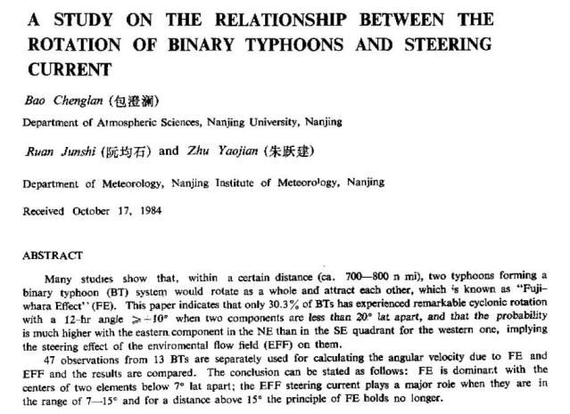
Thank you! I went and looked it up, and found a good deal of scientific literature on this. They are using "binary interaction" because they are talking about the physical effects rather than the cause. So any interaction, no matter how small, IS being caused at least in part by the fujiwhara effect, but also the environmental flow field. It's a combination of the two that must be considered. And regardless, the resulting motion is called a binary interaction and that's what the JTWC is interested in talking about - the resulting motion, not the theory behind it. Here's the opening paragraph from a very good paper on it:
Image

Since they are less than 7 degrees apart in latitude, the FE should be dominant after they are less than 800 miles apart, right?
0 likes   

User avatar
theavocado
Professional-Met
Professional-Met
Posts: 162
Age: 47
Joined: Sun Mar 22, 2009 8:54 pm
Location: NOLA

Re: WPAC : TYPHOON PARMA (19W)

#262 Postby theavocado » Sat Oct 03, 2009 7:09 pm

Bifurcation. This weak steering environment is really posing a challenge to everyone.

Image
0 likes   

User avatar
JTE50
Category 1
Category 1
Posts: 336
Age: 66
Joined: Mon Jul 21, 2008 10:48 am
Location: Pensacola
Contact:

Re: WPAC : TYPHOON PARMA (19W)

#263 Postby JTE50 » Sat Oct 03, 2009 7:18 pm

cycloneye wrote::uarrow: I think that member Typhoon Hunter was going to chase Parma in northern Luzon.Lets see what data he has collected.Apart from him,I havent seen so far information of rainfall totals,maximum winds,and pressure.


James Reynolds is posting updates on his website: http://www.typhoonfury.com
0 likes   

ozonepete
Professional-Met
Professional-Met
Posts: 4743
Joined: Mon Sep 07, 2009 3:23 pm
Location: From Ozone Park, NYC / Now in Brooklyn, NY

Re: WPAC : TYPHOON PARMA (19W)

#264 Postby ozonepete » Sat Oct 03, 2009 7:20 pm

theavocado wrote:Bifurcation. This weak steering environment is really posing a challenge to everyone.


Great example of it (bifurcation.) I assume the forecast tracks going southeastward are anticpating a binary interaction more than the southwestward ones.
0 likes   

JonathanBelles
Professional-Met
Professional-Met
Posts: 11430
Age: 33
Joined: Sat Dec 24, 2005 9:00 pm
Location: School: Florida State University (Tallahassee, FL) Home: St. Petersburg, Florida
Contact:

#265 Postby JonathanBelles » Sat Oct 03, 2009 7:47 pm

I've been watching these two systems with quite intent. I would think that Parma would go SW as Melor would seem to push it at least west at some point. Correct me if I am wrong. Very interesting scenario nonetheless.
0 likes   

User avatar
cycloneye
Admin
Admin
Posts: 139602
Age: 67
Joined: Thu Oct 10, 2002 10:54 am
Location: San Juan, Puerto Rico

Re: WPAC : TYPHOON PARMA (19W)

#266 Postby cycloneye » Sat Oct 03, 2009 7:51 pm

Image

The latest.
0 likes   
Visit the Caribbean-Central America Weather Thread where you can find at first post web cams,radars
and observations from Caribbean basin members Click Here

ozonepete
Professional-Met
Professional-Met
Posts: 4743
Joined: Mon Sep 07, 2009 3:23 pm
Location: From Ozone Park, NYC / Now in Brooklyn, NY

Re: WPAC : TYPHOON PARMA (19W)

#267 Postby ozonepete » Sat Oct 03, 2009 8:37 pm

cycloneye wrote:Image

The latest.


A little ragged from the land interaction, huh? But the center's out over the (very warm) water, and if it starts moving eastward, enough of its circulation will get far enough away from the disruption of the northern Philippine mountains to let it intensify again...
0 likes   

User avatar
cycloneye
Admin
Admin
Posts: 139602
Age: 67
Joined: Thu Oct 10, 2002 10:54 am
Location: San Juan, Puerto Rico

Re: WPAC : TYPHOON PARMA (19W)

#268 Postby cycloneye » Sat Oct 03, 2009 8:38 pm

0300z JTWC Warning=65kts

Look at this new track.

Image

WTPN33 PGTW 040300
MSGID/GENADMIN/NAVMARFCSTCEN PEARL HARBOR HI/JTWC//
SUBJ/TROPICAL CYCLONE WARNING//
RMKS/
1. TYPHOON 19W (PARMA) WARNING NR 026
02 ACTIVE TROPICAL CYCLONES IN NORTHWESTPAC
MAX SUSTAINED WINDS BASED ON ONE-MINUTE AVERAGE
WIND RADII VALID OVER OPEN WATER ONLY
---
WARNING POSITION:
040000Z --- NEAR 18.7N 120.2E
MOVEMENT PAST SIX HOURS - 280 DEGREES AT 07 KTS
POSITION ACCURATE TO WITHIN 060 NM
POSITION BASED ON CENTER LOCATED BY SATELLITE
PRESENT WIND DISTRIBUTION:
MAX SUSTAINED WINDS - 065 KT, GUSTS 080 KT
WIND RADII VALID OVER OPEN WATER ONLY
RADIUS OF 050 KT WINDS - 035 NM NORTHEAST QUADRANT
040 NM SOUTHEAST QUADRANT
040 NM SOUTHWEST QUADRANT
040 NM NORTHWEST QUADRANT
RADIUS OF 034 KT WINDS - 120 NM NORTHEAST QUADRANT
090 NM SOUTHEAST QUADRANT
135 NM SOUTHWEST QUADRANT
140 NM NORTHWEST QUADRANT
REPEAT POSIT: 18.7N 120.2E
---
FORECASTS:
12 HRS, VALID AT:
041200Z --- 19.4N 119.7E
MAX SUSTAINED WINDS - 070 KT, GUSTS 085 KT
WIND RADII VALID OVER OPEN WATER ONLY
RADIUS OF 064 KT WINDS - 015 NM NORTHEAST QUADRANT
015 NM SOUTHEAST QUADRANT
015 NM SOUTHWEST QUADRANT
015 NM NORTHWEST QUADRANT
RADIUS OF 050 KT WINDS - 045 NM NORTHEAST QUADRANT
045 NM SOUTHEAST QUADRANT
045 NM SOUTHWEST QUADRANT
045 NM NORTHWEST QUADRANT
RADIUS OF 034 KT WINDS - 125 NM NORTHEAST QUADRANT
105 NM SOUTHEAST QUADRANT
130 NM SOUTHWEST QUADRANT
135 NM NORTHWEST QUADRANT
VECTOR TO 24 HR POSIT: 330 DEG/ 02 KTS
---
24 HRS, VALID AT:
050000Z --- 19.7N 119.5E
MAX SUSTAINED WINDS - 070 KT, GUSTS 085 KT
WIND RADII VALID OVER OPEN WATER ONLY
RADIUS OF 064 KT WINDS - 015 NM NORTHEAST QUADRANT
015 NM SOUTHEAST QUADRANT
015 NM SOUTHWEST QUADRANT
015 NM NORTHWEST QUADRANT
RADIUS OF 050 KT WINDS - 045 NM NORTHEAST QUADRANT
045 NM SOUTHEAST QUADRANT
045 NM SOUTHWEST QUADRANT
045 NM NORTHWEST QUADRANT
RADIUS OF 034 KT WINDS - 125 NM NORTHEAST QUADRANT
105 NM SOUTHEAST QUADRANT
125 NM SOUTHWEST QUADRANT
130 NM NORTHWEST QUADRANT
VECTOR TO 36 HR POSIT: 300 DEG/ 01 KTS
---
36 HRS, VALID AT:
051200Z --- 19.8N 119.3E
MAX SUSTAINED WINDS - 075 KT, GUSTS 090 KT
WIND RADII VALID OVER OPEN WATER ONLY
RADIUS OF 064 KT WINDS - 020 NM NORTHEAST QUADRANT
020 NM SOUTHEAST QUADRANT
020 NM SOUTHWEST QUADRANT
020 NM NORTHWEST QUADRANT
RADIUS OF 050 KT WINDS - 050 NM NORTHEAST QUADRANT
050 NM SOUTHEAST QUADRANT
050 NM SOUTHWEST QUADRANT
050 NM NORTHWEST QUADRANT
RADIUS OF 034 KT WINDS - 125 NM NORTHEAST QUADRANT
110 NM SOUTHEAST QUADRANT
130 NM SOUTHWEST QUADRANT
135 NM NORTHWEST QUADRANT
VECTOR TO 48 HR POSIT: 240 DEG/ 01 KTS
---
EXTENDED OUTLOOK:
48 HRS, VALID AT:
060000Z --- 19.7N 119.1E
MAX SUSTAINED WINDS - 080 KT, GUSTS 100 KT
WIND RADII VALID OVER OPEN WATER ONLY
RADIUS OF 064 KT WINDS - 025 NM NORTHEAST QUADRANT
025 NM SOUTHEAST QUADRANT
025 NM SOUTHWEST QUADRANT
025 NM NORTHWEST QUADRANT
RADIUS OF 050 KT WINDS - 050 NM NORTHEAST QUADRANT
055 NM SOUTHEAST QUADRANT
055 NM SOUTHWEST QUADRANT
055 NM NORTHWEST QUADRANT
RADIUS OF 034 KT WINDS - 120 NM NORTHEAST QUADRANT
115 NM SOUTHEAST QUADRANT
135 NM SOUTHWEST QUADRANT
135 NM NORTHWEST QUADRANT
VECTOR TO 72 HR POSIT: 190 DEG/ 01 KTS
---
72 HRS, VALID AT:
070000Z --- 19.2N 119.0E
MAX SUSTAINED WINDS - 080 KT, GUSTS 100 KT
WIND RADII VALID OVER OPEN WATER ONLY
RADIUS OF 064 KT WINDS - 025 NM NORTHEAST QUADRANT
025 NM SOUTHEAST QUADRANT
030 NM SOUTHWEST QUADRANT
030 NM NORTHWEST QUADRANT
RADIUS OF 050 KT WINDS - 050 NM NORTHEAST QUADRANT
055 NM SOUTHEAST QUADRANT
055 NM SOUTHWEST QUADRANT
055 NM NORTHWEST QUADRANT
RADIUS OF 034 KT WINDS - 120 NM NORTHEAST QUADRANT
115 NM SOUTHEAST QUADRANT
130 NM SOUTHWEST QUADRANT
130 NM NORTHWEST QUADRANT
VECTOR TO 96 HR POSIT: 195 DEG/ 02 KTS
---
LONG RANGE OUTLOOK:
NOTE...ERRORS FOR TRACK HAVE AVERAGED NEAR 250 NM
ON DAY 4 AND 350 NM ON DAY 5... AND FOR INTENSITY
NEAR 20 KT EACH DAY.
---
96 HRS, VALID AT:
080000Z --- 18.5N 118.8E
MAX SUSTAINED WINDS - 075 KT, GUSTS 090 KT
WIND RADII VALID OVER OPEN WATER ONLY
VECTOR TO 120 HR POSIT: 230 DEG/ 02 KTS
---
120 HRS, VALID AT:
090000Z --- 18.1N 118.3E
MAX SUSTAINED WINDS - 070 KT, GUSTS 085 KT
WIND RADII VALID OVER OPEN WATER ONLY
---
REMARKS:
040300Z POSITION NEAR 18.9N 120.1E. TYPHOON 19W (PARMA), LOCATED
APPROXIMATELY 250 NM NORTH OF MANILA, PHILIPPINES, HAS TRACKED
WESTWARD AT 07 KNOTS OVER THE PAST SIX HOURS. MAXIMUM SIGNIFICANT
WAVE HEIGHT AT 040000Z IS 28 FEET. NEXT WARNINGS AT 040900Z,
041500Z, 042100Z AND 050300Z. REFER TO TROPICAL CYCLONE 20W (MELOR)
WARNINGS (WTPN34 PGTW) FOR SIX-HOURLY UPDATES.//
NNNN

0 likes   
Visit the Caribbean-Central America Weather Thread where you can find at first post web cams,radars
and observations from Caribbean basin members Click Here

ozonepete
Professional-Met
Professional-Met
Posts: 4743
Joined: Mon Sep 07, 2009 3:23 pm
Location: From Ozone Park, NYC / Now in Brooklyn, NY

Re: WPAC : TYPHOON PARMA (19W)

#269 Postby ozonepete » Sat Oct 03, 2009 8:57 pm

cycloneye wrote:0300z JTWC Warning=65kts

Look at this new track.

Image


It looks like they are trying to split the difference over the model results that "theavocado" posted. There is a bifurcation (two fairly distinct and different paths) in the forecast tracks because the models can't decide on the two significant conditions that will affect the forecast track: the pull of MELOR and the remaining steering winds after MELOR starts to move out. Part of the latter problem is deciding how far south the westerlies will dig after MELOR accelerates. A really fascinating forecasting dilemma. I can't wait to see how this plays out.
0 likes   

User avatar
Cyclenall
Category 5
Category 5
Posts: 6628
Joined: Thu Jun 08, 2006 10:01 pm
Location: Ontario, Canada

Re: WPAC : TYPHOON PARMA (19W)

#270 Postby Cyclenall » Sat Oct 03, 2009 9:07 pm

Aslkahuna wrote:Typhoon Ruby in 1976 pulled a hard right after crossing northern Luzon which resulted in severe flooding from Central Luzon north.

Steve

Ok, add those two to the list of Tropical Cyclones that have done that.

If Parma is now a TS, then watch one everyone; they tend to be worse then super typhoons for no reason in the Wpac! It's illogical but it's happening folks :wink: .
0 likes   

ozonepete
Professional-Met
Professional-Met
Posts: 4743
Joined: Mon Sep 07, 2009 3:23 pm
Location: From Ozone Park, NYC / Now in Brooklyn, NY

Re: WPAC : TYPHOON PARMA (19W)

#271 Postby ozonepete » Sat Oct 03, 2009 10:50 pm

Cyclenall wrote:
Aslkahuna wrote:Typhoon Ruby in 1976 pulled a hard right after crossing northern Luzon which resulted in severe flooding from Central Luzon north.

Steve

Ok, add those two to the list of Tropical Cyclones that have done that.

If Parma is now a TS, then watch one everyone; they tend to be worse then super typhoons for no reason in the Wpac! It's illogical but it's happening folks :wink: .


Absolutely. Decaying typhoons or hurricanes have produced some of the worst flooding in recorded history.
0 likes   

User avatar
HURAKAN
Professional-Met
Professional-Met
Posts: 46086
Age: 37
Joined: Thu May 20, 2004 4:34 pm
Location: Key West, FL
Contact:

#272 Postby HURAKAN » Sat Oct 03, 2009 11:25 pm

Image

Very heavy precipitation
0 likes   

User avatar
HURAKAN
Professional-Met
Professional-Met
Posts: 46086
Age: 37
Joined: Thu May 20, 2004 4:34 pm
Location: Key West, FL
Contact:

#273 Postby HURAKAN » Sat Oct 03, 2009 11:49 pm

ZCZC 931
WTPQ51 RJTD 040000
RSMC TROPICAL CYCLONE ADVISORY
NAME STS 0917 PARMA (0917)
ANALYSIS
PSTN 040000UTC 18.8N 120.1E FAIR
MOVE WNW 06KT
PRES 975HPA
MXWD 060KT
GUST 085KT
50KT 40NM
30KT 220NM
FORECAST
24HF 050000UTC 19.4N 119.8E 80NM 70%
MOVE ALMOST STATIONARY
PRES 970HPA
MXWD 065KT
GUST 095KT
48HF 060000UTC 19.4N 119.6E 160NM 70%
MOVE ALMOST STATIONARY
PRES 965HPA
MXWD 070KT
GUST 100KT
72HF 070000UTC 19.1N 119.5E 220NM 70%
MOVE ALMOST STATIONARY
PRES 965HPA
MXWD 070KT
GUST 100KT
96HF 080000UTC 18.8N 119.1E 240NM 70%
MOVE ALMOST STATIONARY
120HF 090000UTC 18.4N 118.4E 300NM 70%
MOVE ALMOST STATIONARY =
NNNN


Image

Very bad scenario
0 likes   

User avatar
Macrocane
Category 5
Category 5
Posts: 4218
Age: 35
Joined: Sun May 24, 2009 5:35 pm
Location: El Salvador

Re: WPAC : SEVERE TROPICAL STORM PARMA (19W)

#274 Postby Macrocane » Sun Oct 04, 2009 12:31 am

I know that the ATL basin is the favorite of most people here, but actually at this time I don't care how boring it has been when the WPAC has brought to us this very inetresting storms and scenarios.
0 likes   

oaba09
S2K Supporter
S2K Supporter
Posts: 1496
Age: 37
Joined: Thu Oct 01, 2009 10:02 am
Location: Valenzuela, Philippines
Contact:

#275 Postby oaba09 » Sun Oct 04, 2009 1:47 am

So, where is parma heading now???? A couple of days ago, it was forecasted to go north east....what a sudden change of direction...
0 likes   

ozonepete
Professional-Met
Professional-Met
Posts: 4743
Joined: Mon Sep 07, 2009 3:23 pm
Location: From Ozone Park, NYC / Now in Brooklyn, NY

Re: WPAC : SEVERE TROPICAL STORM PARMA (19W)

#276 Postby ozonepete » Sun Oct 04, 2009 1:55 am

Macrocane wrote:I know that the ATL basin is the favorite of most people here, but actually at this time I don't care how boring it has been when the WPAC has brought to us this very inetresting storms and scenarios.


Absolutely. We get to observe and then learn how these storms behave no matter where they are in the world. For those of us who are interested in tropical cyclone meteorology, this is a golden opportunity for us to learn and maybe even contribute something to improve forecasting in the future.
0 likes   

User avatar
somethingfunny
ChatStaff
ChatStaff
Posts: 3926
Age: 35
Joined: Thu May 31, 2007 10:30 pm
Location: McKinney, Texas

#277 Postby somethingfunny » Sun Oct 04, 2009 2:00 am

Parma will only be getting uglier from here on...in every sense of the word ugly. The glory days of STY status are behind her but all that rain's got to go somewhere.

My best guess on the track is a counter-clockwise loop west of Luzon and then a NNE ejection out to the east of Taiwan towards the weekend, chasing Melor's tail up into the Bering Sea....but that's a long way off. Normally I'd post the disclaimer but the official agencies don't seem to have a clue whee Parma' heading either! I suppose it's possible that Parma will swing up into southern China east of Hong Kong but I don't really see the mechanism that would push it over there.

Okay fine here's the disclaimer:

The posts in this forum are NOT official forecast and should not be used as such. They are just the opinion of the poster and may or may not be backed by sound meteorological data. They are NOT endorsed by any professional institution or storm2k.org. For official information, please refer to the NHC and NWS products
0 likes   

Typhoon10
Category 1
Category 1
Posts: 290
Age: 53
Joined: Sat Sep 12, 2009 11:55 pm
Location: Singapore

Re: WPAC : SEVERE TROPICAL STORM PARMA (19W)

#278 Postby Typhoon10 » Sun Oct 04, 2009 3:54 am

I really hope that Parma picks up strength, HK's dry monsoon subsides and then it heads straight up towards HK and I can experience my 1st real Typhoon! :D

If I was dreaming, Melor also just speeds westwards picking up strength, goes inbetween Philippines and Taiwan, picks up Parma along the way, turns into a Cat 6 Typhoon and heads towards Hong Kong. Now that would be amazing! :cheesy:
0 likes   

oaba09
S2K Supporter
S2K Supporter
Posts: 1496
Age: 37
Joined: Thu Oct 01, 2009 10:02 am
Location: Valenzuela, Philippines
Contact:

#279 Postby oaba09 » Sun Oct 04, 2009 5:07 am

pretty interesting thing going on between parma & melor....I just wish parma doesn't pass central luzon IF ever it passes luzon again...
0 likes   

beaufort12
S2K Supporter
S2K Supporter
Posts: 70
Joined: Thu Sep 02, 2004 9:18 am
Location: Lorton VA

Re: WPAC : SEVERE TROPICAL STORM PARMA (19W)

#280 Postby beaufort12 » Sun Oct 04, 2009 5:30 am

as others have said, this is an interesting scenario to watch. we do not need this to come to china and they certainly don't need it in vietnam. my wishcast is for some meandering around and weakening via upwelling, then a hard ne turn through the luzon strait and then south of taiwan and bye bye.
0 likes   


Return to “2009”

Who is online

Users browsing this forum: No registered users and 13 guests