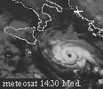
05/1200 UTC 44.3N 17.1W T3.5/3.5 GRACE
Very nice!
ATL : TROPICAL STORM GRACE
Moderator: S2k Moderators

-
ozonepete
- Professional-Met

- Posts: 4743
- Joined: Mon Sep 07, 2009 3:23 pm
- Location: From Ozone Park, NYC / Now in Brooklyn, NY
Re:
leanne_uk wrote:She real is a little stunner, like I said yesterday, Small but perfectly formed
Hey Leanne! I can't believe you've got yourself a TC. Who knows, maybe even a hurricane comin' at you. Enjoy it!
0 likes

Re: ATL : TROPICAL STORM GRACE

It's very small.And now it has an eye....
I think it can be a hurricane.
0 likes
-
Cookie

- S2K Supporter

- Posts: 477
- Age: 38
- Joined: Sun Dec 14, 2008 11:13 am
- Location: Isle Of lewis scotland
Re: ATL : TROPICAL STORM GRACE
not something you see every day in the uk
The general synopsis at 0700
Low just west of Rockall 998 expected Faeroes 982 by 0700 tomorrow. Tropical storm grace moving steadily northeast expected Sole 988 by same time. Low Biscay 1002 losing its identity by that time
0 likes
-
leanne_uk
- Tropical Storm

- Posts: 214
- Age: 43
- Joined: Fri Sep 04, 2009 4:38 pm
- Location: Loughborough countryside, Leicestershire, UK
She is a stunner though and its great that this is one I have saw develop fron the very beginning, make me just a little happy
0 likes
-
ozonepete
- Professional-Met
- Posts: 4743
- Joined: Mon Sep 07, 2009 3:23 pm
- Location: From Ozone Park, NYC / Now in Brooklyn, NY
Re:
leanne_uk wrote::uarrow: Pete as much as I would love a hurricane I really cant see grace holding herself well enough over the next 24-36 hours in the cooler waters to give the UK anything to worry about at all should she continue to track NE.
She is a stunner though and its great that this is one I have saw develop fron the very beginning, make me just a little happy
Oh yeah, I know it can never hold up as tropical over those waters, but you might get a puff of wind and some rain out of it, although more likely whatever's left will move more over Ireland.
0 likes
-
wxman57

- Moderator-Pro Met

- Posts: 23177
- Age: 68
- Joined: Sat Jun 21, 2003 8:06 pm
- Location: Houston, TX (southwest)
Re: ATL : TROPICAL STORM GRACE
FrontRunner wrote:wxman57 wrote:NHC is truly bored.
I see. So do you believe boredom has caused them to identify and accurately classify a tropical cyclone?
Or do you dispute the fact that this should be classified as such?
I'm in the JB camp on this one. Lows like this would never have been classified as TCs in the past, and I don't think they should be now. Occluded low over cool water? Phase diagrams indicate symmetric cold core, though they may not resolve this small feature well. There's no reason to name it and NOT name a similar low that developed over much warmer water before moving ashore into the East U.S. Coast during the peak of the season.
0 likes
-
leanne_uk
- Tropical Storm
- Posts: 214
- Age: 43
- Joined: Fri Sep 04, 2009 4:38 pm
- Location: Loughborough countryside, Leicestershire, UK
Re: Re:
ozonepete wrote:leanne_uk wrote::uarrow: Pete as much as I would love a hurricane I really cant see grace holding herself well enough over the next 24-36 hours in the cooler waters to give the UK anything to worry about at all should she continue to track NE.
She is a stunner though and its great that this is one I have saw develop fron the very beginning, make me just a little happy
Oh yeah, I know it can never hold up as tropical over those waters, but you might get a puff of wind and some rain out of it, although more likely whatever's left will move more over Ireland.
I dont mind what Grace does or where she ends up providing that I get to see her in action even if its via sat feeds till she is no more than that little puff of wind
I just am amazed like many at the ability this system has had to hold its own already so far north. Alot of things to learn still it appears but more information is never a bad thing
0 likes
-
ozonepete
- Professional-Met
- Posts: 4743
- Joined: Mon Sep 07, 2009 3:23 pm
- Location: From Ozone Park, NYC / Now in Brooklyn, NY
Re: ATL : TROPICAL STORM GRACE
wxman57 wrote:FrontRunner wrote:wxman57 wrote:NHC is truly bored.
I see. So do you believe boredom has caused them to identify and accurately classify a tropical cyclone?
Or do you dispute the fact that this should be classified as such?
I'm in the JB camp on this one. Lows like this would never have been classified as TCs in the past, and I don't think they should be now. Occluded low over cool water? Phase diagrams indicate symmetric cold core, though they may not resolve this small feature well. There's no reason to name it and NOT name a similar low that developed over much warmer water before moving ashore into the East U.S. Coast during the peak of the season.
Lows like this couldn't be classified in the past - we didn't have the technology. Now that we do have the technology to make the determination that it's tropical (and it sure looks like it to the NHC and most of us) then why should we or the NHC ignore it, or worse, incorrectly classify it because it's small!! It does not look occluded at all and none of the surface analysis shows that. It appears to have a warm core with a convective ring around it; even a classic structure including what appears to be an eye and spiral bands. Tiny, yes. Insignificant? No, quite the opposite. It's historical.
0 likes
-
pepeavilenho
- Tropical Storm
- Posts: 171
- Joined: Thu Jul 09, 2009 12:01 pm


-
DanieleItalyRm
- Category 1

- Posts: 487
- Age: 40
- Joined: Mon Sep 22, 2008 7:52 am
- Location: Rome - Italy - Mediterranean sea
Re: ATL : TROPICAL STORM GRACE
wxman57 wrote:FrontRunner wrote:wxman57 wrote:NHC is truly bored.
I see. So do you believe boredom has caused them to identify and accurately classify a tropical cyclone?
Or do you dispute the fact that this should be classified as such?
I'm in the JB camp on this one. Lows like this would never have been classified as TCs in the past, and I don't think they should be now. Occluded low over cool water? Phase diagrams indicate symmetric cold core, though they may not resolve this small feature well. There's no reason to name it and NOT name a similar low that developed over much warmer water before moving ashore into the East U.S. Coast during the peak of the season.
NHC in the past classified many others system like a Grace to TC or Hurricane, whith cold core origin and over cool water (20-24°C).
example: Karl 1980, Unnamed Hurricane 1991, Vince 2005, ecc.
Last edited by DanieleItalyRm on Mon Oct 05, 2009 9:27 am, edited 2 times in total.
0 likes


-
Derek Ortt
Re: ATL : TROPICAL STORM GRACE
wxman57 wrote:FrontRunner wrote:wxman57 wrote:NHC is truly bored.
I see. So do you believe boredom has caused them to identify and accurately classify a tropical cyclone?
Or do you dispute the fact that this should be classified as such?
I'm in the JB camp on this one. Lows like this would never have been classified as TCs in the past, and I don't think they should be now. Occluded low over cool water? Phase diagrams indicate symmetric cold core, though they may not resolve this small feature well. There's no reason to name it and NOT name a similar low that developed over much warmer water before moving ashore into the East U.S. Coast during the peak of the season.
I have to believe you are mistaken here
The phase diagrams are model analyses and should not be used in making the determination as to whether or not something is tropical. besides, given the small size of the cyclone, it won't be accurately resolved
To me, this meets the definition and should be classified. The issue is with not classifying these cyclones in the past
0 likes
-
HURAKAN

- Professional-Met
- Posts: 46084
- Age: 39
- Joined: Thu May 20, 2004 4:34 pm
- Location: Key West, FL
- Contact:
Re: ATL : TROPICAL STORM GRACE
Jeff Masters - Link: http://www.wunderground.com/blog/JeffMa ... rynum=1340
Surprise! A 70-mph tropical storm popped up seemingly out of nowhere early this morning, in a region of the Atlantic not ordinarily prone to tropical storm formation. Tropical Storm Grace formed at 41.2° north latitude, in a remote ocean area near the Azores Islands. This is the farthest northeast an Atlantic tropical storm has ever formed since satellite observations began in the 1960s. Since 1960, only one tropical storm has formed farther north--Tropical Storm Alberto of 1988, which formed at 41.5°N, off the coast of Cape Cod, Massachusetts. Satellite imagery revealed that Grace formed an eyewall and well-defined eye this morning, though the storm's tropical storm-force winds did not extend out very far from the center. Last night, the center of Grace passed about 20 miles west of Ponta Delgada in the eastern Azores, which recorded sustained winds of 31 mph, gusting to 44 mph. Grace formed over chilly waters of about 23°C, well below the usual threshold of 26°C required for tropical storm formation. Grace's formation was aided by some very cold temperatures in the upper atmosphere (-54°C at 200 mb), which made the atmosphere more unstable than usual. The storm won't be around much longer, as Grace is already over much colder waters of 21°C, and is headed towards even colder waters.
Surprise! A 70-mph tropical storm popped up seemingly out of nowhere early this morning, in a region of the Atlantic not ordinarily prone to tropical storm formation. Tropical Storm Grace formed at 41.2° north latitude, in a remote ocean area near the Azores Islands. This is the farthest northeast an Atlantic tropical storm has ever formed since satellite observations began in the 1960s. Since 1960, only one tropical storm has formed farther north--Tropical Storm Alberto of 1988, which formed at 41.5°N, off the coast of Cape Cod, Massachusetts. Satellite imagery revealed that Grace formed an eyewall and well-defined eye this morning, though the storm's tropical storm-force winds did not extend out very far from the center. Last night, the center of Grace passed about 20 miles west of Ponta Delgada in the eastern Azores, which recorded sustained winds of 31 mph, gusting to 44 mph. Grace formed over chilly waters of about 23°C, well below the usual threshold of 26°C required for tropical storm formation. Grace's formation was aided by some very cold temperatures in the upper atmosphere (-54°C at 200 mb), which made the atmosphere more unstable than usual. The storm won't be around much longer, as Grace is already over much colder waters of 21°C, and is headed towards even colder waters.
0 likes
-
wxman57
- Moderator-Pro Met
- Posts: 23177
- Age: 68
- Joined: Sat Jun 21, 2003 8:06 pm
- Location: Houston, TX (southwest)
Re:
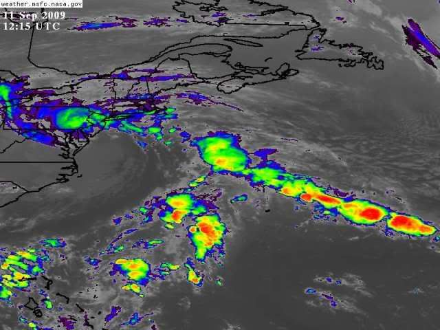
HURAKAN wrote:NON-TROPICAL SYSTEM IN NJ:
http://i40.photobucket.com/albums/e244/ ... 4cwwrZ.jpg
GRACE:
http://oiswww.eumetsat.org/IPPS/html/MS ... kXcPA1L2Mv
BIG DIFFERENCE
Of course there's a difference if you show the New Jersey system after it moved inland and transformed to an extratopical low. But find a satellite shot from 36 hours earlier when it was over the Gulf stream. The only reason Grace isn't attached to a front is that it's an occluded low. And the "unnamed storm of 1991" wasn't named.
Now I'm not necessarily saying Grace should NOT have been named, but that the naming process lacks consistency. You can't name Grace and ignore two other more tropical lows over very warm water this season.
0 likes
-
wxman57
- Moderator-Pro Met
- Posts: 23177
- Age: 68
- Joined: Sat Jun 21, 2003 8:06 pm
- Location: Houston, TX (southwest)
Re:
Better, almost as "good" looking as Grace. But it reached its peak (and was more warm-core) the evening before that sat pic was taken. By first light, it was already transitioning. Remember when the center passed over the buoy east of Delaware? The temperature at the buoy rose 7 degrees. That's a sign of a warm core low.
See an analysis below. Not "on" the front, but behind it in the cold air. If the system off the Mid Atlantic Coast didn't qualify for naming because of proximity to a front, then Grace doesn't either. Consistency is all I ask.

Last edited by wxman57 on Mon Oct 05, 2009 9:48 am, edited 1 time in total.
0 likes
-
HURAKAN
- Professional-Met
- Posts: 46084
- Age: 39
- Joined: Thu May 20, 2004 4:34 pm
- Location: Key West, FL
- Contact:
715
WTNT34 KNHC 051445
TCPAT4
BULLETIN
TROPICAL STORM GRACE ADVISORY NUMBER 3
NWS TPC/NATIONAL HURRICANE CENTER MIAMI FL AL092009
1100 AM AST MON OCT 05 2009
...GRACE RACING NORTH-NORTHEASTWARD BETWEEN THE AZORES AND THE
BRITISH ISLES...
AT 1100 AM AST...1500 UTC...THE CENTER OF TROPICAL STORM GRACE WAS
LOCATED NEAR LATITUDE 45.4 NORTH...LONGITUDE 16.4 WEST OR ABOUT 575
MILES...925 KM...SOUTHWEST OF CORK IRELAND...AND ABOUT 590 MILES...
950 KM....NORTHWEST OF LISBON PORTUGAL.
GRACE IS MOVING TOWARD THE NORTH-NORTHEAST NEAR 31 MPH...50 KM/HR.
THIS GENERAL MOTION WITH A DECREASE IN FORWARD SPEED IS EXPECTED
OVER THE NEXT 24 HOURS.
MAXIMUM SUSTAINED WINDS HAVE DECREASED TO NEAR 65 MPH...100 KM/HR...
WITH HIGHER GUSTS. ADDITIONAL WEAKENING IS EXPECTED DURING THE NEXT
DAY OR SO...AND GRACE SHOULD BE ABSORBED BY A FRONT BY TUESDAY
MORNING.
TROPICAL STORM FORCE WINDS EXTEND OUTWARD UP TO 70 MILES...110
KM...MAINLY TO THE SOUTH OF THE CENTER.
ESTIMATED MINIMUM CENTRAL PRESSURE IS 990 MB...29.23 INCHES.
...SUMMARY OF 1100 AM AST INFORMATION...
LOCATION...45.4N 16.4W
MAXIMUM SUSTAINED WINDS...65 MPH
PRESENT MOVEMENT...NORTH-NORTHEAST OR 30 DEGREES AT 31 MPH
MINIMUM CENTRAL PRESSURE...990 MB
THE NEXT ADVISORY WILL BE ISSUED BY THE NATIONAL HURRICANE CENTER AT
500 PM AST.
$$
FORECASTER BERG
155
WTNT44 KNHC 051445
TCDAT4
TROPICAL STORM GRACE DISCUSSION NUMBER 3
NWS TPC/NATIONAL HURRICANE CENTER MIAMI FL AL092009
1100 AM AST MON OCT 05 2009
THE CONVECTIVE STRUCTURE OF GRACE HAS BEGUN TO DETERIORATE
SLIGHTLY...WITH THE RING OF DEEP CONVECTION AROUND THE CENTER
BECOMING LESS SYMMETRIC AND FRACTURED. THE INITIAL INTENSITY IS
LOWERED TO 55 KT ON THIS ADVISORY BASED ON TROPICAL AND SUBTROPICAL
CLASSIFICATIONS OF 3.5...AND A 0644 UTC QUIKSCAT PASS WHICH
SUPPORTED MAXIMUM WINDS BETWEEN 50 AND 55 KT. ALSO...GRACE IS NOW
OVER WATER NEAR 18C...AND THIS IS LIKELY INHIBITING STRONG
CONVECTIVE MIXING OF WINDS TO THE SURFACE. SOME ADDITIONAL
WEAKENING IS ANTICIPATED OVER THE NEXT 24 HOURS...AND THE GLOBAL
MODELS ALL INDICATE THAT GRACE SHOULD BE ABSORBED BY A FRONT JUST
SOUTHWEST OF IRELAND BY TUESDAY MORNING.
GRACE IS ACCELERATING WITH AN INITIAL MOTION OF 30 DEGREES AT 27 KT.
THE CYCLONE IS EXPECTED TO TURN TOWARD THE NORTH-NORTHEAST AND SLOW
DOWN OVER THE NEXT 12 TO 24 HOURS AS IT MOVES NORTH OF THE STRONGEST
BELT OF MID-LATITUDE WESTERLIES...AND BECOMES ABSORBED BY THE
FRONTAL BOUNDARY TO ITS NORTHWEST.
DESPITE THE FACT THAT GRACE IS MOVING OVER VERY COLD WATERS...AN
AMSU PASS FROM EARLIER TODAY STILL SHOWS THE PRESENCE OF A MODERATE
TO DEEP WARM CORE IN ASSOCIATION WITH THE CYCLONE. IN ADDITION...
THE WIND RADII HAVE BEEN ADJUSTED BASED ON THE 0644 UTC QUIKSCAT
PASS.
FORECAST POSITIONS AND MAX WINDS
INITIAL 05/1500Z 45.4N 16.4W 55 KT
12HR VT 06/0000Z 48.0N 14.6W 50 KT
24HR VT 06/1200Z...ABSORBED BY A FRONT
$$
FORECASTER BERG
0 likes
Who is online
Users browsing this forum: No registered users and 34 guests