ATL: TROPICAL STORM BILL (03L)
Moderator: S2k Moderators


Re: ATL: TROPICAL STORM BILL (03L)
Just checked Bill out. Bill was projected to pass 14.1 N 43.7 W at 11 am this morning. Right now it is located about .5 degrees south of this forecast point. Bill passed is about 7 hours ahead of schedule speed wise and a bit south of the forecast track. Also still seems to be flying westward. It will be interesting to see when this finally crosses 14N. If it stays south of14N at the next advisory point it will be pretty far south of the current forecast track.
0 likes
-
JonathanBelles
- Professional-Met

- Posts: 11430
- Age: 35
- Joined: Sat Dec 24, 2005 9:00 pm
- Location: School: Florida State University (Tallahassee, FL) Home: St. Petersburg, Florida
- Contact:
-
Derek Ortt
Re: ATL: TROPICAL STORM BILL (03L)
Normandy wrote:Just checked Bill out. Bill was projected to pass 14.1 N 43.7 W at 11 am this morning. Right now it is located about .5 degrees south of this forecast point. Bill passed is about 7 hours ahead of schedule speed wise and a bit south of the forecast track. Also still seems to be flying westward. It will be interesting to see when this finally crosses 14N. If it stays south of14N at the next advisory point it will be pretty far south of the current forecast track.
Bill was not forecast to pass those points at 11 A.M.
All forecasts are synoptic time, not advisory time. It was expected to be at those points at 8 A.M. It is about 4 hours ahead of schedule, not 7
0 likes
-
southerngale

- Retired Staff

- Posts: 27418
- Joined: Thu Oct 10, 2002 1:27 am
- Location: Southeast Texas (Beaumont area)
000
WTNT33 KNHC 170854
TCPAT3
BULLETIN
HURRICANE BILL ADVISORY NUMBER 8
NWS TPC/NATIONAL HURRICANE CENTER MIAMI FL AL032009
500 AM AST MON AUG 17 2009
...BILL NOW A HURRICANE...THE FIRST OF THE 2009 ATLANTIC SEASON...
AT 500 AM AST...0900 UTC...THE CENTER OF HURRICANE BILL WAS LOCATED
NEAR LATITUDE 13.8 NORTH...LONGITUDE 44.0 WEST OR ABOUT 1160 MILES
...1870 KM...EAST OF THE LESSER ANTILLES.
BILL IS MOVING QUICKLY TOWARD THE WEST-NORTHWEST NEAR 22 MPH...35
KM/HR...AND THIS GENERAL MOTION IS EXPECTED TO CONTINUE FOR THE
NEXT 24 TO 48 HOURS.
MAXIMUM SUSTAINED WINDS HAVE INCREASED TO NEAR 75 MPH...120 KM/HR.
STRENGTHENING IS FORECAST DURING THE NEXT DAY OR TWO...AND BILL
COULD BECOME A MAJOR HURRICANE BY WEDNESDAY.
HURRICANE FORCE WINDS EXTEND OUTWARD UP TO 30 MILES...45 KM...FROM
THE CENTER...AND TROPICAL STORM FORCE WINDS EXTEND OUTWARD UP TO 145
MILES...230 KM.
ESTIMATED MINIMUM CENTRAL PRESSURE IS 987 MB...29.15 INCHES.
...SUMMARY OF 500 AM AST INFORMATION...
LOCATION...13.8N 44.0W
MAXIMUM SUSTAINED WINDS...75 MPH
PRESENT MOVEMENT...WEST-NORTHWEST OR 285 DEGREES AT 22 MPH
MINIMUM CENTRAL PRESSURE...987 MB
THE NEXT ADVISORY WILL BE ISSUED BY THE NATIONAL HURRICANE CENTER AT
1100 AM AST.
$$
FORECASTER KIMBERLAIN/BROWN
---------------------------------------------------------------------------------------------------
000
WTNT43 KNHC 170856
TCDAT3
HURRICANE BILL DISCUSSION NUMBER 8
NWS TPC/NATIONAL HURRICANE CENTER MIAMI FL AL032009
500 AM AST MON AUG 17 2009
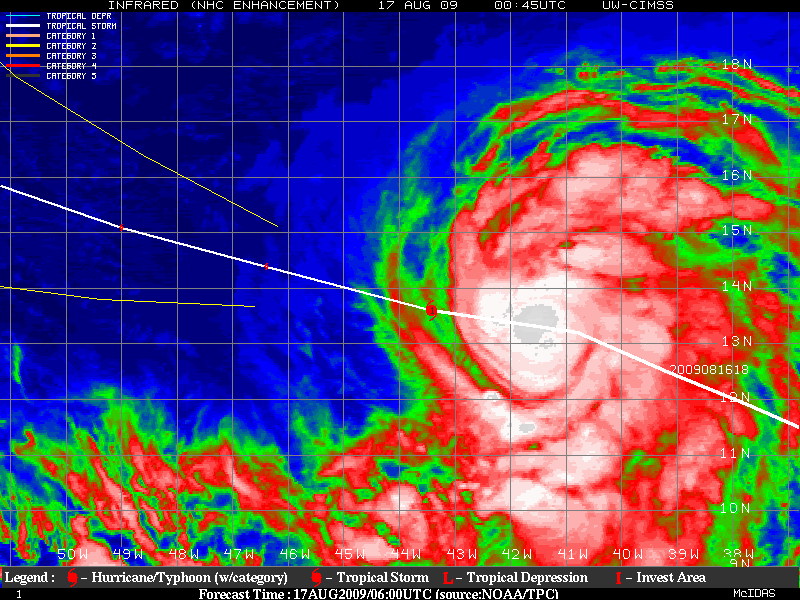
INFRARED SATELLITE PICTURES REVEAL AN IMPRESSIVE MASS OF DEEP
CONVECTION...WITH A LARGE AREA OF -70C AND EVEN -80C CLOUD
TOPS WITHIN A WELL-ORGANIZED CENTRAL DENSE OVERCAST. IN
ADDITION...SEVERAL WELL-DEFINED BANDS ARE NOTED OUTSIDE OF THE
CENTRAL CONVECTIVE CORE. A 0142 UTC TRMM PASS INDICATED A DISTINCT
CONVECTIVE RING AROUND THE CENTER...ALSO SUGGESTIVE OF INCREASED
ORGANIZATION. DVORAK T-NUMBERS ARE AT 4.0 FROM TAFB AND SAB...ALONG
WITH CURRENT TRENDS...SUPPORT INCREASING THE INITIAL INTENSITY TO
65 KT. THIS MAKES BILL THE FIRST HURRICANE OF THE 2009 ATLANTIC
HURRICANE SEASON.
RECENT SATELLITE CENTER FIXES ARE LESS DOUBTFUL THAN EARLIER AND
YIELD A RATHER RAPID INITIAL MOTION ESTIMATE OF 285/19. GLOBAL
MODELS ARE IN GOOD AGREEMENT ON A GENERAL WEST-NORTHWEST TRACK FOR
THE NEXT DAY OR TWO...AS BILL IS STEERED BY A DEEP-LAYER RIDGE
NORTHEAST OF THE CYCLONE. HOWEVER...WATER VAPOR IMAGERY SHOWS A
WEAKNESS CURRENTLY ALONG 50W...WHICH IS FORECAST TO BEGIN ERODING A
PORTION OF THE SUBTROPICAL RIDGE OVER THE CENTRAL ATLANTIC OVER THE
NEXT 48 HOURS. AS THE BREAK IN THE RIDGE BECOMES MORE
SUBSTANTIAL...A MAJORITY OF THE MODEL GUIDANCE TURNS BILL ON A MORE
NORTHWESTWARD COURSE LATE IN THE FORECAST PERIOD. THE ONE EXCEPTION
IS THE UKMET WHICH INSISTS ON A MORE SOUTHERN SOLUTION. THE
OFFICIAL TRACK IS INITIALLY NUDGED SLIGHTLY SOUTHWARD IN THE
SHORT-TERM TO ACCOUNT FOR A MORE CERTAIN INITIAL POSITION...BUT
LITTLE CHANGE WAS MADE TO THE PREVIOUS TRACK THEREAFTER.
BILL IS EXPECTED TO TRACK THROUGH AN ENVIRONMENT CHARACTERIZED BY
LOW SHEAR AND SEA SURFACE TEMPERATURES JUST UNDER 27C THROUGH 24
HOURS. SIMILAR TO BEFORE...THE GFDL/HWRF INDICATE A NEARLY FLAT
RATE OF INTENSIFICATION FOR THE NEXT DAY OR TWO...PERHAPS
REFLECTING MARGINALLY WARM WATERS. IN SPITE OF THIS...THE SHIPS
RAPID INTENSIFICATION INDEX HAS CONTINUED FORECASTING A RATHER HIGH
PROBABILITY OF A 30 KT INTENSITY INCREASE DURING THE NEXT 24 HOURS.
THEREAFTER...ALL INTENSITY GUIDANCE INDICATES A CONDUCIVE
ENVIRONMENT FOR STRENGTHENING...WHICH SHOULD ALLOW BILL TO BECOME A
MAJOR HURRICANE. THE OFFICIAL FORECAST FOLLOWS SUIT...CLOSEST TO
THE SHIPS MODEL GUIDANCE. TOWARD THE END OF THE FORECAST
PERIOD...SEVERAL OF THE RELIABLE GLOBAL MODELS SUGGEST INCREASING
WESTERLY SHEAR AS BILL IS SEPARATED FROM ITS FAVORABLE...UPPER-
LEVEL SUPPORT. CONSEQUENTLY...THE OFFICIAL INTENSITY FORECAST
INDICATES MINOR WEAKENING NEAR THE END OF THE PERIOD.
IT APPEARS AS IF THE CENTER OF BILL WILL PASS VERY CLOSE TO NOAA
BUOY 41041 LATER THIS MORNING.
FORECAST POSITIONS AND MAX WINDS
INITIAL 17/0900Z 13.8N 44.0W 65 KT
12HR VT 17/1800Z 14.4N 46.4W 75 KT
24HR VT 18/0600Z 15.1N 49.0W 85 KT
36HR VT 18/1800Z 16.0N 51.6W 95 KT
48HR VT 19/0600Z 17.3N 54.0W 105 KT
72HR VT 20/0600Z 20.5N 59.0W 110 KT
96HR VT 21/0600Z 25.0N 63.5W 105 KT
120HR VT 22/0600Z 30.1N 66.5W 100 KT
$$
FORECASTER KIMBERLAIN
WTNT33 KNHC 170854
TCPAT3
BULLETIN
HURRICANE BILL ADVISORY NUMBER 8
NWS TPC/NATIONAL HURRICANE CENTER MIAMI FL AL032009
500 AM AST MON AUG 17 2009
...BILL NOW A HURRICANE...THE FIRST OF THE 2009 ATLANTIC SEASON...
AT 500 AM AST...0900 UTC...THE CENTER OF HURRICANE BILL WAS LOCATED
NEAR LATITUDE 13.8 NORTH...LONGITUDE 44.0 WEST OR ABOUT 1160 MILES
...1870 KM...EAST OF THE LESSER ANTILLES.
BILL IS MOVING QUICKLY TOWARD THE WEST-NORTHWEST NEAR 22 MPH...35
KM/HR...AND THIS GENERAL MOTION IS EXPECTED TO CONTINUE FOR THE
NEXT 24 TO 48 HOURS.
MAXIMUM SUSTAINED WINDS HAVE INCREASED TO NEAR 75 MPH...120 KM/HR.
STRENGTHENING IS FORECAST DURING THE NEXT DAY OR TWO...AND BILL
COULD BECOME A MAJOR HURRICANE BY WEDNESDAY.
HURRICANE FORCE WINDS EXTEND OUTWARD UP TO 30 MILES...45 KM...FROM
THE CENTER...AND TROPICAL STORM FORCE WINDS EXTEND OUTWARD UP TO 145
MILES...230 KM.
ESTIMATED MINIMUM CENTRAL PRESSURE IS 987 MB...29.15 INCHES.
...SUMMARY OF 500 AM AST INFORMATION...
LOCATION...13.8N 44.0W
MAXIMUM SUSTAINED WINDS...75 MPH
PRESENT MOVEMENT...WEST-NORTHWEST OR 285 DEGREES AT 22 MPH
MINIMUM CENTRAL PRESSURE...987 MB
THE NEXT ADVISORY WILL BE ISSUED BY THE NATIONAL HURRICANE CENTER AT
1100 AM AST.
$$
FORECASTER KIMBERLAIN/BROWN
---------------------------------------------------------------------------------------------------
000
WTNT43 KNHC 170856
TCDAT3
HURRICANE BILL DISCUSSION NUMBER 8
NWS TPC/NATIONAL HURRICANE CENTER MIAMI FL AL032009
500 AM AST MON AUG 17 2009
INFRARED SATELLITE PICTURES REVEAL AN IMPRESSIVE MASS OF DEEP
CONVECTION...WITH A LARGE AREA OF -70C AND EVEN -80C CLOUD
TOPS WITHIN A WELL-ORGANIZED CENTRAL DENSE OVERCAST. IN
ADDITION...SEVERAL WELL-DEFINED BANDS ARE NOTED OUTSIDE OF THE
CENTRAL CONVECTIVE CORE. A 0142 UTC TRMM PASS INDICATED A DISTINCT
CONVECTIVE RING AROUND THE CENTER...ALSO SUGGESTIVE OF INCREASED
ORGANIZATION. DVORAK T-NUMBERS ARE AT 4.0 FROM TAFB AND SAB...ALONG
WITH CURRENT TRENDS...SUPPORT INCREASING THE INITIAL INTENSITY TO
65 KT. THIS MAKES BILL THE FIRST HURRICANE OF THE 2009 ATLANTIC
HURRICANE SEASON.
RECENT SATELLITE CENTER FIXES ARE LESS DOUBTFUL THAN EARLIER AND
YIELD A RATHER RAPID INITIAL MOTION ESTIMATE OF 285/19. GLOBAL
MODELS ARE IN GOOD AGREEMENT ON A GENERAL WEST-NORTHWEST TRACK FOR
THE NEXT DAY OR TWO...AS BILL IS STEERED BY A DEEP-LAYER RIDGE
NORTHEAST OF THE CYCLONE. HOWEVER...WATER VAPOR IMAGERY SHOWS A
WEAKNESS CURRENTLY ALONG 50W...WHICH IS FORECAST TO BEGIN ERODING A
PORTION OF THE SUBTROPICAL RIDGE OVER THE CENTRAL ATLANTIC OVER THE
NEXT 48 HOURS. AS THE BREAK IN THE RIDGE BECOMES MORE
SUBSTANTIAL...A MAJORITY OF THE MODEL GUIDANCE TURNS BILL ON A MORE
NORTHWESTWARD COURSE LATE IN THE FORECAST PERIOD. THE ONE EXCEPTION
IS THE UKMET WHICH INSISTS ON A MORE SOUTHERN SOLUTION. THE
OFFICIAL TRACK IS INITIALLY NUDGED SLIGHTLY SOUTHWARD IN THE
SHORT-TERM TO ACCOUNT FOR A MORE CERTAIN INITIAL POSITION...BUT
LITTLE CHANGE WAS MADE TO THE PREVIOUS TRACK THEREAFTER.
BILL IS EXPECTED TO TRACK THROUGH AN ENVIRONMENT CHARACTERIZED BY
LOW SHEAR AND SEA SURFACE TEMPERATURES JUST UNDER 27C THROUGH 24
HOURS. SIMILAR TO BEFORE...THE GFDL/HWRF INDICATE A NEARLY FLAT
RATE OF INTENSIFICATION FOR THE NEXT DAY OR TWO...PERHAPS
REFLECTING MARGINALLY WARM WATERS. IN SPITE OF THIS...THE SHIPS
RAPID INTENSIFICATION INDEX HAS CONTINUED FORECASTING A RATHER HIGH
PROBABILITY OF A 30 KT INTENSITY INCREASE DURING THE NEXT 24 HOURS.
THEREAFTER...ALL INTENSITY GUIDANCE INDICATES A CONDUCIVE
ENVIRONMENT FOR STRENGTHENING...WHICH SHOULD ALLOW BILL TO BECOME A
MAJOR HURRICANE. THE OFFICIAL FORECAST FOLLOWS SUIT...CLOSEST TO
THE SHIPS MODEL GUIDANCE. TOWARD THE END OF THE FORECAST
PERIOD...SEVERAL OF THE RELIABLE GLOBAL MODELS SUGGEST INCREASING
WESTERLY SHEAR AS BILL IS SEPARATED FROM ITS FAVORABLE...UPPER-
LEVEL SUPPORT. CONSEQUENTLY...THE OFFICIAL INTENSITY FORECAST
INDICATES MINOR WEAKENING NEAR THE END OF THE PERIOD.
IT APPEARS AS IF THE CENTER OF BILL WILL PASS VERY CLOSE TO NOAA
BUOY 41041 LATER THIS MORNING.
FORECAST POSITIONS AND MAX WINDS
INITIAL 17/0900Z 13.8N 44.0W 65 KT
12HR VT 17/1800Z 14.4N 46.4W 75 KT
24HR VT 18/0600Z 15.1N 49.0W 85 KT
36HR VT 18/1800Z 16.0N 51.6W 95 KT
48HR VT 19/0600Z 17.3N 54.0W 105 KT
72HR VT 20/0600Z 20.5N 59.0W 110 KT
96HR VT 21/0600Z 25.0N 63.5W 105 KT
120HR VT 22/0600Z 30.1N 66.5W 100 KT
$$
FORECASTER KIMBERLAIN
0 likes
-
Evil Jeremy

- S2K Supporter

- Posts: 5463
- Age: 32
- Joined: Mon Apr 10, 2006 2:10 pm
- Location: Los Angeles, CA
Re: ATL: HURRICANE BILL (03L)
Oh my bad, I just added 12 hours to the advisory time of 11AM.
0 likes
-
JonathanBelles
- Professional-Met
- Posts: 11430
- Age: 35
- Joined: Sat Dec 24, 2005 9:00 pm
- Location: School: Florida State University (Tallahassee, FL) Home: St. Petersburg, Florida
- Contact:
-
southerngale
- Retired Staff
- Posts: 27418
- Joined: Thu Oct 10, 2002 1:27 am
- Location: Southeast Texas (Beaumont area)


Re: ATL: HURRICANE BILL (Models)
I see a weakness up around 30N -50W in the water vapor imagery but it isn't dropping south very quickly and it almost looks like Bill will be running under the east side of a building ridge?
The model consensus is a little deceiving since they all have their different reasons to explain the recurve. My guess is the trough or weakness will show up later in the forecast rather than near -60w.
The model consensus is a little deceiving since they all have their different reasons to explain the recurve. My guess is the trough or weakness will show up later in the forecast rather than near -60w.
0 likes
-
cycloneye

- Admin

- Posts: 149322
- Age: 69
- Joined: Thu Oct 10, 2002 10:54 am
- Location: San Juan, Puerto Rico
Re: ATL: HURRICANE BILL (03L)
Here is the bouy that NHC mentions at discussion where Bill will pass very close.Pressure is falling fast and winds picking up.
http://www.ndbc.noaa.gov/station_page.php?station=41041
http://www.ndbc.noaa.gov/station_page.php?station=41041
0 likes
The GFS now even misses Bermuda and nearly Newfoundland...just to remember NO storm has ever missed Newfoundland from how deep Bill was in latitude, so I'm a little doubtful about the new GFS runs...
Bill really wrapping itself round, steady strengthening appears to be the case with this one.
Bill really wrapping itself round, steady strengthening appears to be the case with this one.
0 likes
Re:
Unsheared developing hurricane in the atlantic during an el nino year.....shocking~
(well not really....shear changes all the time, no matter what)
(well not really....shear changes all the time, no matter what)
O Town wrote:Bill looking strong this A.M. also looks to be right on NHCs track thus far.
0 likes
-
tolakram
- Admin
- Posts: 20181
- Age: 62
- Joined: Sun Aug 27, 2006 8:23 pm
- Location: Florence, KY (name is Mark)
Re:
O Town wrote:Bill looking strong this A.M. also looks to be right on NHCs track thus far.
...picture removed...
Keep in mind the track is updated every advisory so you'll want to capture a picture just before NHC releases their forecast.
0 likes
Who is online
Users browsing this forum: No registered users and 290 guests