WPAC: SEVERE TROPICAL STORM LUPIT (22W)
Moderator: S2k Moderators

-
drdavisjr

- Category 1

- Posts: 428
- Age: 58
- Joined: Mon Oct 12, 2009 7:07 am
- Location: Marilao, Bulacan, Philippines
- Contact:
Re: WPAC: TYPHOON LUPIT (22W)
My worry over here is that according to JTWC, this storm should be at a 300 degree climb north by now...actually long overdue.
I see a westward movement, albeit slow. If the steering ridge to the north doesnt weaken, we folks in Manila are in for a wet time; and maybe even windy time.
I see a westward movement, albeit slow. If the steering ridge to the north doesnt weaken, we folks in Manila are in for a wet time; and maybe even windy time.
0 likes
-
beaufort12
- S2K Supporter

- Posts: 70
- Joined: Thu Sep 02, 2004 9:18 am
- Location: Lorton VA
Re: WPAC: TYPHOON LUPIT (22W)
In my opinion we have another storm that will not harmlessly recurve. I do not want to make light of the very serious potential danger to the Philippines, but I am starting to wonder what this could mean for Hong Kong.
0 likes
-
ozonepete
- Professional-Met

- Posts: 4743
- Joined: Mon Sep 07, 2009 3:23 pm
- Location: From Ozone Park, NYC / Now in Brooklyn, NY
Re: WPAC: TYPHOON LUPIT (22W)
beaufort12 wrote:In my opinion we have another storm that will not harmlessly recurve. I do not want to make light of the very serious potential danger to the Philippines, but I am starting to wonder what this could mean for Hong Kong.
I'm starting to wonder the same thing. Although it's way too early to tell, that is a distinct possibility if the rebuilding subtropical ridge becomes substantial.
0 likes
-
drdavisjr
- Category 1
- Posts: 428
- Age: 58
- Joined: Mon Oct 12, 2009 7:07 am
- Location: Marilao, Bulacan, Philippines
- Contact:
Re: WPAC: TYPHOON LUPIT (22W)
beaufort12 wrote:In my opinion we have another storm that will not harmlessly recurve. I do not want to make light of the very serious potential danger to the Philippines, but I am starting to wonder what this could mean for Hong Kong.
I am certainly not even a skilled observer, but I can look at a forecast track and compare it to a satellite loop and see this storm is south of the forecast track, and has been consistently today. Now, I don't know if this track will hold or not, but if this storm hits anywhere in central to north central Luzon, there are at least 3 if not more dams that will overflow; they are already at their spilling level. Nearly the entire province of Pangasinan was underwater less than 1 week ago after Parma spent a week going back and forth.
Now, for Metro Manila...
There have been over 1,000 cases of leptospirosis reported in the past 2 weeks due to poor folks STILL walking around in flood waters. I guess you could say we've had our share this year, and it doesn't look like it's over yet.
0 likes


Re: WPAC: TYPHOON LUPIT (22W)
beaufort12 wrote:In my opinion we have another storm that will not harmlessly recurve. I do not want to make light of the very serious potential danger to the Philippines, but I am starting to wonder what this could mean for Hong Kong.
I agree. Even if it does recurve, someone would be in for it unless it does a full U-turn. Due to what I've seen from the water temperature thermic map someone posted earlier, the system going over us right now (been a cool, stormy night here in Okinawa and it's been cool all week), I am inclined to believe the JTWC and other sources saying it's going straight to Luzon and not poleward. Upper level and water conditions this way aren't exactly favorable up here, at present. But this is all the opinion of a novice and not a professional. If there are any contradicting sources of info, I'd like to see them, too!
I'm sure the military here are already monitoring this and preparing to send more aid...because it looks like the Philippines are going to need it.
0 likes
-
drdavisjr
- Category 1
- Posts: 428
- Age: 58
- Joined: Mon Oct 12, 2009 7:07 am
- Location: Marilao, Bulacan, Philippines
- Contact:
Re: WPAC: TYPHOON LUPIT (22W)
Infdidoll wrote:beaufort12 wrote:In my opinion we have another storm that will not harmlessly recurve. I do not want to make light of the very serious potential danger to the Philippines, but I am starting to wonder what this could mean for Hong Kong.
I agree. Even if it does recurve, someone would be in for it unless it does a full U-turn. Due to what I've seen from the water temperature thermic map someone posted earlier, the system going over us right now (been a cool, stormy night here in Okinawa and it's been cool all week), I am inclined to believe the JTWC and other sources saying it's going straight to Luzon and not poleward. Upper level and water conditions this way aren't exactly favorable up here, at present. But this is all the opinion of a novice and not a professional. If there are any contradicting sources of info, I'd like to see them, too!
I'm sure the military here are already monitoring this and preparing to send more aid...because it looks like the Philippines are going to need it.
I know. When Parma was approaching the country, we in Manila were very glad that we didn't get hit. But that meant that the north was hit, and that is sad, too.
This year is telling me and my wife that maybe it's time to head to the States to live.
0 likes
-
ricmood
Re: WPAC: TYPHOON LUPIT (22W)
drdavisjr wrote:Infdidoll wrote:beaufort12 wrote:In my opinion we have another storm that will not harmlessly recurve. I do not want to make light of the very serious potential danger to the Philippines, but I am starting to wonder what this could mean for Hong Kong.
I agree. Even if it does recurve, someone would be in for it unless it does a full U-turn. Due to what I've seen from the water temperature thermic map someone posted earlier, the system going over us right now (been a cool, stormy night here in Okinawa and it's been cool all week), I am inclined to believe the JTWC and other sources saying it's going straight to Luzon and not poleward. Upper level and water conditions this way aren't exactly favorable up here, at present. But this is all the opinion of a novice and not a professional. If there are any contradicting sources of info, I'd like to see them, too!
I'm sure the military here are already monitoring this and preparing to send more aid...because it looks like the Philippines are going to need it.
I know. When Parma was approaching the country, we in Manila were very glad that we didn't get hit. But that meant that the north was hit, and that is sad, too.
This year is telling me and my wife that maybe it's time to head to the States to live.
Good point, it really sucks here the past weeks.
We haven't really recovered yet from ketsana and parma,
but here we go again. This one is bigger than Philippines.
Were you leaving here already when tphoon milenyo hits metro
manila 3 years back?
0 likes


Re: WPAC: TYPHOON LUPIT (22W)
The posts in this forum are NOT official forecast and should not be used as such. They are just the opinion of the poster and may or may not be backed by sound meteorological data. They are NOT endorsed by any professional institution or storm2k.org. For official information, please refer to the NHC and NWS products.
Lupit is an amazing huge typhoon with strong convection and good outflow, it's too bad that it is not froecasted to be a fish storm. The entire circulation of Lupit is almost the same size of the Philippines if it doesn't reduce its size it will affect a big part of the country even if it makes landfall on the northern tip. Also, as other members have mentioned it looks like it's going westward when it was forecasted to move northwestward and that could mean a landfall a little more south than predicted.
Lupit is an amazing huge typhoon with strong convection and good outflow, it's too bad that it is not froecasted to be a fish storm. The entire circulation of Lupit is almost the same size of the Philippines if it doesn't reduce its size it will affect a big part of the country even if it makes landfall on the northern tip. Also, as other members have mentioned it looks like it's going westward when it was forecasted to move northwestward and that could mean a landfall a little more south than predicted.
0 likes
-
drdavisjr
- Category 1
- Posts: 428
- Age: 58
- Joined: Mon Oct 12, 2009 7:07 am
- Location: Marilao, Bulacan, Philippines
- Contact:
Re: WPAC: TYPHOON LUPIT (22W)
ricmood wrote:Good point, it really sucks here the past weeks.
We haven't really recovered yet from ketsana and parma,
but here we go again. This one is bigger than Philippines.
Were you leaving here already when tphoon milenyo hits metro
manila 3 years back?
Yes, I was. It was a bit windy but not much rain. Our power was off for about 6-7 hours (wow, very humid that day). The next day or so, we saw all the billboards along EDSA toppled over. I remember that a few even hit some cars (which makes me wonder who would drive down EDSA in a typhoon.)
One thing ricmood, I cannot understand how these storms catch so many people outside their homes here in Manila...simply unbelievable. I won't let my family outside house at least a few hours before they hit until they are over.
0 likes

-
cycloneye

- Admin

- Posts: 149825
- Age: 69
- Joined: Thu Oct 10, 2002 10:54 am
- Location: San Juan, Puerto Rico
Re: WPAC: TYPHOON LUPIT (22W)
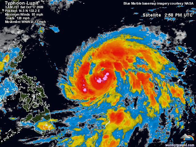
18 UTC JMA Warning
TY 0920 (Lupit)
Issued at 18:40 UTC, 16 October 2009
<Analyses at 16/18 UTC>
Scale -
Intensity Strong
Center position N14°30'(14.5°)
E133°10'(133.2°)
Direction and speed of movement WNW 20km/h(11kt)
Central pressure 970hPa
Maximum wind speed near the center 35m/s(65kt)
Maximum wind gust speed 50m/s(95kt)
Area of 50kt winds or more Wide 110km(60NM)
Area of 30kt winds or more NE440km(240NM)
SW370km(200NM)
0 likes
Visit the Caribbean-Central America Weather Thread where you can find at first post web cams,radars
and observations from Caribbean basin members Click Here
and observations from Caribbean basin members Click Here
-
HURAKAN

- Professional-Met
- Posts: 46084
- Age: 39
- Joined: Thu May 20, 2004 4:34 pm
- Location: Key West, FL
- Contact:
ZCZC 778
WTPQ20 RJTD 161800
RSMC TROPICAL CYCLONE ADVISORY
NAME TY 0920 LUPIT (0920)
ANALYSIS
PSTN 161800UTC 14.5N 133.2E FAIR
MOVE WNW 11KT
PRES 970HPA
MXWD 065KT
GUST 095KT
50KT 60NM
30KT 240NM NORTHEAST 200NM SOUTHWEST
FORECAST
24HF 171800UTC 15.8N 131.0E 70NM 70%
MOVE WNW 06KT
PRES 950HPA
MXWD 080KT
GUST 115KT
48HF 181800UTC 16.3N 130.6E 110NM 70%
MOVE ALMOST STATIONARY
PRES 930HPA
MXWD 090KT
GUST 130KT
72HF 191800UTC 17.0N 128.5E 160NM 70%
MOVE WNW SLOWLY
PRES 930HPA
MXWD 090KT
GUST 130KT =
NNNN
0 likes
-
P.K.

- Professional-Met
- Posts: 5149
- Joined: Thu Sep 23, 2004 5:57 pm
- Location: Watford, England
- Contact:
Re: WPAC: TYPHOON LUPIT (22W)
CMA expecting a very strong typhoon in four days.
WTPQ20 BABJ 161800
SUBJECTIVE FORECAST
TY LUPIT 0920 (0920) INITIAL TIME 161800 UTC
00HR 14.4N 133.3E 975HPA 33M/S
30KTS 400KM
50KTS 100KM
P12HR WNW 15KM/H
P+24HR 15.6N 131.0E 960HPA 40M/S
P+48HR 16.2N 130.3E 950HPA 45M/S
P+72HR 17.0N 128.3E 940HPA 50M/S
P+96HR 17.9N 124.3E 930HPA 55M/S=
WTPQ20 BABJ 161800
SUBJECTIVE FORECAST
TY LUPIT 0920 (0920) INITIAL TIME 161800 UTC
00HR 14.4N 133.3E 975HPA 33M/S
30KTS 400KM
50KTS 100KM
P12HR WNW 15KM/H
P+24HR 15.6N 131.0E 960HPA 40M/S
P+48HR 16.2N 130.3E 950HPA 45M/S
P+72HR 17.0N 128.3E 940HPA 50M/S
P+96HR 17.9N 124.3E 930HPA 55M/S=
0 likes

-
cycloneye
- Admin
- Posts: 149825
- Age: 69
- Joined: Thu Oct 10, 2002 10:54 am
- Location: San Juan, Puerto Rico
Re: WPAC: TYPHOON LUPIT (22W)
JTWC 2100z Warning=85kts
WTPN31 PGTW 162100
MSGID/GENADMIN/NAVMARFCSTCEN PEARL HARBOR HI/JTWC//
SUBJ/TROPICAL CYCLONE WARNING//
RMKS/
1. TYPHOON 22W (LUPIT) WARNING NR 012
01 ACTIVE TROPICAL CYCLONE IN NORTHWESTPAC
MAX SUSTAINED WINDS BASED ON ONE-MINUTE AVERAGE
WIND RADII VALID OVER OPEN WATER ONLY
---
WARNING POSITION:
161800Z --- NEAR 14.5N 133.2E
MOVEMENT PAST SIX HOURS - 285 DEGREES AT 11 KTS
POSITION ACCURATE TO WITHIN 040 NM
POSITION BASED ON EYE FIXED BY SATELLITE
PRESENT WIND DISTRIBUTION:
MAX SUSTAINED WINDS - 085 KT, GUSTS 105 KT
WIND RADII VALID OVER OPEN WATER ONLY
RADIUS OF 064 KT WINDS - 030 NM NORTHEAST QUADRANT
025 NM SOUTHEAST QUADRANT
025 NM SOUTHWEST QUADRANT
030 NM NORTHWEST QUADRANT
RADIUS OF 050 KT WINDS - 040 NM NORTHEAST QUADRANT
040 NM SOUTHEAST QUADRANT
030 NM SOUTHWEST QUADRANT
040 NM NORTHWEST QUADRANT
RADIUS OF 034 KT WINDS - 110 NM NORTHEAST QUADRANT
085 NM SOUTHEAST QUADRANT
080 NM SOUTHWEST QUADRANT
125 NM NORTHWEST QUADRANT
REPEAT POSIT: 14.5N 133.2E
---
FORECASTS:
12 HRS, VALID AT:
170600Z --- 14.8N 132.3E
MAX SUSTAINED WINDS - 095 KT, GUSTS 115 KT
WIND RADII VALID OVER OPEN WATER ONLY
RADIUS OF 064 KT WINDS - 020 NM NORTHEAST QUADRANT
020 NM SOUTHEAST QUADRANT
020 NM SOUTHWEST QUADRANT
020 NM NORTHWEST QUADRANT
RADIUS OF 050 KT WINDS - 050 NM NORTHEAST QUADRANT
050 NM SOUTHEAST QUADRANT
045 NM SOUTHWEST QUADRANT
050 NM NORTHWEST QUADRANT
RADIUS OF 034 KT WINDS - 120 NM NORTHEAST QUADRANT
100 NM SOUTHEAST QUADRANT
100 NM SOUTHWEST QUADRANT
130 NM NORTHWEST QUADRANT
VECTOR TO 24 HR POSIT: 300 DEG/ 03 KTS
---
24 HRS, VALID AT:
171800Z --- 15.1N 131.8E
MAX SUSTAINED WINDS - 105 KT, GUSTS 130 KT
WIND RADII VALID OVER OPEN WATER ONLY
RADIUS OF 064 KT WINDS - 025 NM NORTHEAST QUADRANT
025 NM SOUTHEAST QUADRANT
025 NM SOUTHWEST QUADRANT
025 NM NORTHWEST QUADRANT
RADIUS OF 050 KT WINDS - 060 NM NORTHEAST QUADRANT
060 NM SOUTHEAST QUADRANT
055 NM SOUTHWEST QUADRANT
060 NM NORTHWEST QUADRANT
RADIUS OF 034 KT WINDS - 130 NM NORTHEAST QUADRANT
115 NM SOUTHEAST QUADRANT
110 NM SOUTHWEST QUADRANT
130 NM NORTHWEST QUADRANT
VECTOR TO 36 HR POSIT: 330 DEG/ 03 KTS
---
36 HRS, VALID AT:
180600Z --- 15.6N 131.5E
MAX SUSTAINED WINDS - 115 KT, GUSTS 140 KT
WIND RADII VALID OVER OPEN WATER ONLY
RADIUS OF 064 KT WINDS - 035 NM NORTHEAST QUADRANT
035 NM SOUTHEAST QUADRANT
035 NM SOUTHWEST QUADRANT
035 NM NORTHWEST QUADRANT
RADIUS OF 050 KT WINDS - 070 NM NORTHEAST QUADRANT
065 NM SOUTHEAST QUADRANT
065 NM SOUTHWEST QUADRANT
070 NM NORTHWEST QUADRANT
RADIUS OF 034 KT WINDS - 135 NM NORTHEAST QUADRANT
120 NM SOUTHEAST QUADRANT
115 NM SOUTHWEST QUADRANT
135 NM NORTHWEST QUADRANT
VECTOR TO 48 HR POSIT: 310 DEG/ 04 KTS
---
EXTENDED OUTLOOK:
48 HRS, VALID AT:
181800Z --- 16.1N 130.9E
MAX SUSTAINED WINDS - 120 KT, GUSTS 145 KT
WIND RADII VALID OVER OPEN WATER ONLY
RADIUS OF 064 KT WINDS - 045 NM NORTHEAST QUADRANT
040 NM SOUTHEAST QUADRANT
040 NM SOUTHWEST QUADRANT
045 NM NORTHWEST QUADRANT
RADIUS OF 050 KT WINDS - 065 NM NORTHEAST QUADRANT
065 NM SOUTHEAST QUADRANT
060 NM SOUTHWEST QUADRANT
065 NM NORTHWEST QUADRANT
RADIUS OF 034 KT WINDS - 130 NM NORTHEAST QUADRANT
120 NM SOUTHEAST QUADRANT
115 NM SOUTHWEST QUADRANT
130 NM NORTHWEST QUADRANT
VECTOR TO 72 HR POSIT: 290 DEG/ 07 KTS
---
72 HRS, VALID AT:
191800Z --- 17.0N 128.0E
MAX SUSTAINED WINDS - 125 KT, GUSTS 150 KT
WIND RADII VALID OVER OPEN WATER ONLY
RADIUS OF 064 KT WINDS - 045 NM NORTHEAST QUADRANT
040 NM SOUTHEAST QUADRANT
040 NM SOUTHWEST QUADRANT
045 NM NORTHWEST QUADRANT
RADIUS OF 050 KT WINDS - 070 NM NORTHEAST QUADRANT
065 NM SOUTHEAST QUADRANT
065 NM SOUTHWEST QUADRANT
070 NM NORTHWEST QUADRANT
RADIUS OF 034 KT WINDS - 130 NM NORTHEAST QUADRANT
120 NM SOUTHEAST QUADRANT
125 NM SOUTHWEST QUADRANT
135 NM NORTHWEST QUADRANT
VECTOR TO 96 HR POSIT: 285 DEG/ 11 KTS
---
LONG RANGE OUTLOOK:
NOTE...ERRORS FOR TRACK HAVE AVERAGED NEAR 250 NM
ON DAY 4 AND 350 NM ON DAY 5... AND FOR INTENSITY
NEAR 20 KT EACH DAY.
---
96 HRS, VALID AT:
201800Z --- 18.0N 123.4E
MAX SUSTAINED WINDS - 130 KT, GUSTS 160 KT
WIND RADII VALID OVER OPEN WATER ONLY
VECTOR TO 120 HR POSIT: 280 DEG/ 12 KTS
---
120 HRS, VALID AT:
211800Z --- 18.8N 118.2E
MAX SUSTAINED WINDS - 105 KT, GUSTS 130 KT
WIND RADII VALID OVER OPEN WATER ONLY
---
REMARKS:
162100Z POSITION NEAR 14.6N 133.0E. TYPHOON (TY) 22W (LUPIT),
LOCATED APPROXIMATELY 500 NM NORTH OF PALAU, HAS TRACKED WEST-
NORTHWESTWARD AT 11 KNOTS OVER THE PAST SIX HOURS. RECENT ANIMATED
INFRARED IMAGERY SHOWS AN IMPRESSIVE, TIGHTLY ORGANIZED SYSTEM WITH
MULTIPLE CONVECTIVE BANDS WRAPPING INTO THE LOW LEVEL CIRCULATION
CENTER (LLCC). ALSO EVIDENT IS A SLIGHT DEFORMATION OF THE SYSTEM ON
THE NORTHWEST SIDE DUE TO AN APPROACHING MIDLATITUDE TROUGH. 161658Z
AMSR-E MICROWAVE PASS SHOWS MULTIPLE DEEP CONVECTIVE BANDS WRAPPING
INTO AN EYE-LIKE FEATURE. THE STRUCTURE HAS IMPROVED GREATLY IN THE
LAST 12 HOURS AS THE SYSTEM HAS RAPIDLY INTENSIFIED, AS BASED ON
INTENSITY ESTIMATES FROM PGTW OF 90KTS AND KNES OF 77KTS. THE SYSTEM
IS CURRENTLY STEERING ALONG THE SOUTHERN PERIPHERY OF THE EAST-WEST
ORIENTED SUBTROPICAL RIDGE (STR) TO THE NORTH. THE APPROACH OF THE
AFOREMENTIONED MIDLATITUDE TROUGH WILL SLIGHTLY WEAKEN THE STR AND
ALLOW FOR THE SYSTEM TO CONTINUE SLOWING AND TRACK SLIGHTLY POLEWARD
AS THE STEERING INFLUENCE IS DISRUPTED. UPON COMPLETION OF THE
TROUGH PASSAGE, THE RIDGE IS EXPECTED TO REBUILD AND THE SYSTEM WILL
ACCELERATE TO THE WEST. DURING THE PERIOD WHERE THE TROUGH IS TO THE
NORTH OF THE SYSTEM, POLEWARD OUTFLOW IS EXPECTED TO INCREASE
CONSIDERABLY AND THE SYSTEM WILL CONTINUE TO RAPIDLY INTENSIFY
THROUGH TAU 48 BEFORE LEVELING OFF NEAR SUPER TYPHOON STRENGTH.
NUMERICAL GUIDANCE IS IN FAIR AGREEMENT THROUGH TAU 48 WITH
DISCREPANCIES IN THE DEGREE THAT THE SYSTEM WILL TURN POLEWARD IN
RESPONSE TO THE MIDLATITUDE TROUGH. TCLAPS, GFDN AND GFS TRACK THE
SYSTEM MORE POLEWARD IN EXCESSIVE RESPONSE TO THE MIDLATITUDE TROUGH
WITH UKMO, ECMWF, JGSM AND NOGAPS GIVING LESS RESPONSE. THIS
FORECAST FAVORS THE LATTER SOLUTION BASED ON ANALYSIS OF THE STR AND
SPEED OF THE MIDLATITUDE TROUGH IN THE ZONAL FLOW. MAXIMUM
SIGNIFICANT WAVE HEIGHT AT 161800Z IS 18 FEET. NEXT WARNINGS AT
170300Z, 170900Z, 171500Z AND 172100Z.//
NNNN
0 likes
Visit the Caribbean-Central America Weather Thread where you can find at first post web cams,radars
and observations from Caribbean basin members Click Here
and observations from Caribbean basin members Click Here

Who is online
Users browsing this forum: No registered users and 11 guests