
Yeah I think the fact it is suggesting a pattern change is interesting. I'm paying a huge deal of attention on the GFS at the moment for the change simply because its resolution when its progged to change is lower so its not probably doing a great job in picking it up and still being overly progressive.
Still doesn't change the fact that this one is probably be way to north to be a real threat to the US and unless a beast of a ridge develops, which at the moment isn't really progged.
ATL : TROPICAL DEPRESSION ERIKA (06L)
Moderator: S2k Moderators
-
Stormcenter
- S2K Supporter

- Posts: 6689
- Joined: Wed Sep 03, 2003 11:27 am
- Location: Houston, TX
Re: ATL : INVEST 94L - Computer Models
So far it is and from my vantage point it still looks that way.
Rainband wrote:The last thing the US needs now is a disaster. I hope this season is a season of fish
0 likes
-
otowntiger
- Category 5

- Posts: 1932
- Joined: Tue Aug 31, 2004 7:06 pm
Re: ATL : INVEST 94L - Computer Models
Based on the models now I'm going to forecast that this thing will be more of a threat to the Azores than it will be the Antilles.Stormcenter wrote:So far it is and from my vantage point it still looks that way.Rainband wrote:The last thing the US needs now is a disaster. I hope this season is a season of fish
0 likes
-
Bocadude85

- Category 5
- Posts: 2991
- Age: 39
- Joined: Mon Apr 18, 2005 2:20 pm
- Location: Honolulu,Hi
Re: ATL : INVEST 94L
This is at 10N and moving slowly... I dont see how this would not be caught under the ridge... those of you that think everything will recurve this season will have a big helping of crow a month from now.
0 likes
-
cycloneye

- Admin

- Posts: 149839
- Age: 69
- Joined: Thu Oct 10, 2002 10:54 am
- Location: San Juan, Puerto Rico
Re: ATL : INVEST 94L
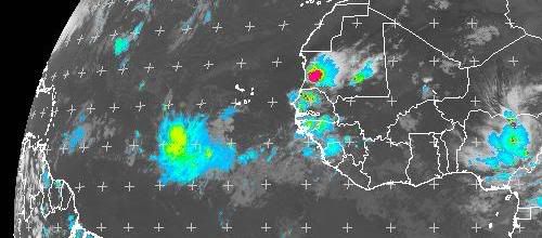
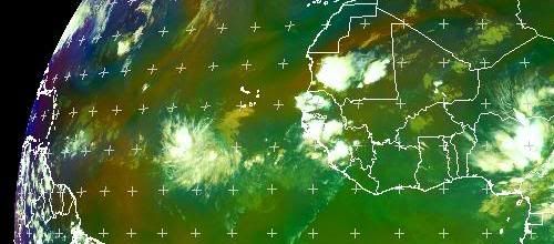
Anyway most of the convection is to the west so probably some sort of shear from the east on it at the moment, though its more likely that its still developing.
More retarding in developing,more west it goes and that means more closer to Lesser Antilles.
0 likes
-
David in FL

- Tropical Low

- Posts: 28
- Joined: Mon Aug 10, 2009 12:57 am
- Location: Jacksonville Beach, FL
Re: ATL : INVEST 94L
What is it about the current conditions this year causeing all these storms to recurve, not that I am complaining. Also does anyone think the storm still in Africa could do anything? thanks
0 likes

Re: ATL : INVEST 94L
Bocadude85 wrote:This is at 10N and moving slowly... I dont see how this would not be caught under the ridge... those of you that think everything will recurve this season will have a big helping of crow a month from now.
Decide in the next few days Bocadude; what condiments you want for your crow; ketchup, BBQ sauce, Salsa.......
This Invest is developing early and will most probably recurve well before the islands..
Perhaps you can order side dishes and maybe some chianti????
0 likes
-
HURAKAN

- Professional-Met

- Posts: 46084
- Age: 39
- Joined: Thu May 20, 2004 4:34 pm
- Location: Key West, FL
- Contact:
Re: ATL : INVEST 94L - Computer Models
otowntiger wrote:Based on the models now I'm going to forecast that this thing will be more of a threat to the Azores than it will be the Antilles.
It all depends on how fast the system develops
0 likes
-
Blown Away

- S2K Supporter
- Posts: 10253
- Joined: Wed May 26, 2004 6:17 am
Re: ATL : INVEST 94L - Computer Models
First, I don't put much into the first run of models on a system in the far E Atlantic. 94L is down low near 10N and I think the models are way to aggressive bringing 94L from 10N/30W near 20N before 45W, use climatology, how often do these systems recurve that quickly that far out in the Atlantic? Looking at the end of the recurve model runs I see that subtle W bend. IMO, 94L will continue W and will start to feel the weakness in about 3-5 days which will allow 94L to gain latitude but not enough to recurve. The BH will begin to build, 94L will be near 55W, and the BH will drive 94L more to the W.
0 likes
-
Stormcenter
- S2K Supporter
- Posts: 6689
- Joined: Wed Sep 03, 2003 11:27 am
- Location: Houston, TX
Re: ATL : INVEST 94L - Computer Models
Hmmmmmm.......I heard the same type of talk for Bill and it didn't
(west movement) happen.
(west movement) happen.
Blown_away wrote:First, I don't put much into the first run of models on a system in the far E Atlantic. 94L is down low near 10N and I think the models are way to aggressive bringing 94L from 10N/30W near 20N before 45W, use climatology, how often do these systems recurve that quickly that far out in the Atlantic? Looking at the end of the recurve model runs I see that subtle W bend. IMO, 94L will continue W and will start to feel the weakness in about 3-5 days which will allow 94L to gain latitude but not enough to recurve. The BH will begin to build, 94L will be near 55W, and the BH will drive 94L more to the W.
0 likes


-
Bocadude85
- Category 5
- Posts: 2991
- Age: 39
- Joined: Mon Apr 18, 2005 2:20 pm
- Location: Honolulu,Hi
Re: ATL : INVEST 94L
fci wrote:Bocadude85 wrote:This is at 10N and moving slowly... I dont see how this would not be caught under the ridge... those of you that think everything will recurve this season will have a big helping of crow a month from now.
Decide in the next few days Bocadude; what condiments you want for your crow; ketchup, BBQ sauce, Salsa.......
This Invest is developing early and will most probably recurve well before the islands..
Perhaps you can order side dishes and maybe some chianti????
LOL I have no problem eating crow... my point is that this has not developed as of yet and will cross 30w and possibly 35w before becoming a TD. And yes this could miss the islands to the north but if that ridge that the models are showing does build in this will be forced back to the west. A lot of people seem to think its not possible to go from east coast troughs to east coast ridging... we have seen it before and we will see it again.. 2004 had a east coast trough that pulled charley into Florida and several systems into the Carolinas. The when late August/September came around the Bermuda High built in which was a complete pattern change from what we had the 3 months prior. Not saying this is like 2004 just saying patterns do and can change.
0 likes
-
Dean4Storms
- S2K Supporter
- Posts: 6358
- Age: 63
- Joined: Sun Aug 31, 2003 1:01 pm
- Location: Miramar Bch. FL
-
Blown Away
- S2K Supporter
- Posts: 10253
- Joined: Wed May 26, 2004 6:17 am
Re: ATL : INVEST 94L - Computer Models
Stormcenter wrote:Hmmmmmm.......I heard the same type of talk for Bill and it didn't
(west movement) happen.Blown_away wrote:First, I don't put much into the first run of models on a system in the far E Atlantic. 94L is down low near 10N and I think the models are way to aggressive bringing 94L from 10N/30W near 20N before 45W, use climatology, how often do these systems recurve that quickly that far out in the Atlantic? Looking at the end of the recurve model runs I see that subtle W bend. IMO, 94L will continue W and will start to feel the weakness in about 3-5 days which will allow 94L to gain latitude but not enough to recurve. The BH will begin to build, 94L will be near 55W, and the BH will drive 94L more to the W.
If I'm recalling correctly, pretty much from the beginning the models showed a recurve w/ Bill. 94L's first run shows some W and some beginning a recurve but jog back W at the end run. I'm thinking that is indication the trough will be strong enough to pull 94L a little N but not strong enough to recurve 94L.
Last edited by Blown Away on Thu Aug 27, 2009 6:20 pm, edited 1 time in total.
0 likes
-
Bocadude85
- Category 5
- Posts: 2991
- Age: 39
- Joined: Mon Apr 18, 2005 2:20 pm
- Location: Honolulu,Hi
Re: ATL : INVEST 94L - Computer Models
I recall someone mentioning Ana not sure if it was in this thread or not but the models showed Ana recurving early on.. and well we all know that never happened.
0 likes
-
Bocadude85
- Category 5
- Posts: 2991
- Age: 39
- Joined: Mon Apr 18, 2005 2:20 pm
- Location: Honolulu,Hi
Re:
HURAKAN wrote:Let the storm develop and then we can talk about the future. It's a large system and they typically take some days to develop.
I agree it may take another 2-3 days for this to develop.
0 likes
Who is online
Users browsing this forum: No registered users and 51 guests