
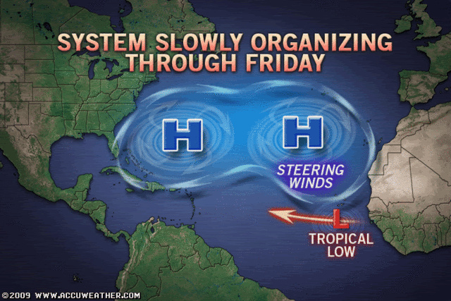
Seems to me like the models are progging some sort of weakness in the central Atlantic as the Bermuda high splits into two high pressure cells.
This is going to be interesting to watch as this is going to be the only thing that I can see saving the E.Caribbean. CMC shows this quite clearly. Meanwhiloe the GFS barely has the feature.
Given the last weakness was overdone I've got a bad feeling the GFS will be closer to the truth but we shall see.
ATL: TROPICAL STORM BILL (03L)
Moderator: S2k Moderators
-
dolebot_Broward_NW
- Category 2

- Posts: 529
- Joined: Fri Sep 10, 2004 6:38 am
Re: ATL: Invest 90L
Here's the map for 90l's position. I'm not liking TD2's historical map at all. Not cool at all when the NHC puts the NE Leewards in the cone.

My image is based on 90l, if it were a TD or greater right now. tolakrams is frightening, quite a few impact the eastern carribean and with GFS predicting the end of the world as we know it with 90l.... yikes.
My image is based on 90l, if it were a TD or greater right now. tolakrams is frightening, quite a few impact the eastern carribean and with GFS predicting the end of the world as we know it with 90l.... yikes.
0 likes
-
HURAKAN

- Professional-Met

- Posts: 46084
- Age: 39
- Joined: Thu May 20, 2004 4:34 pm
- Location: Key West, FL
- Contact:
394
WHXX04 KWBC 131720
CHGQLM
ATTENTION...NATIONAL HURRICANE CENTER
NCEP COUPLED GFDL HURRICANE MODEL FORECAST MADE FOR
TROPICAL DEPRESSION INVEST 90L
INITIAL TIME 12Z AUG 13
DISCLAIMER ... THIS INFORMATION IS PROVIDED AS GUIDANCE. IT
REQUIRES INTERPRETATION BY HURRICANE SPECIALISTS AND SHOULD
NOT BE CONSIDERED AS A FINAL PRODUCT. PLEASE SEE THE TPC/NHC
OFFICIAL FORECAST.
FORECAST STORM POSITION
HOUR LATITUDE LONGITUDE HEADING/SPEED(KT)
0 11.9 22.2 280./ 7.0
6 11.9 24.3 272./20.4
12 12.4 25.4 292./12.0
18 12.5 27.4 273./19.4
24 11.9 28.9 249./15.3
30 11.4 29.6 236./ 8.7
36 11.4 30.2 264./ 5.5
42 11.6 30.8 288./ 6.5
48 11.7 32.2 273./14.3
54 11.9 33.4 280./11.3
60 12.2 34.9 283./15.1
66 12.4 36.8 275./18.3
72 12.6 38.5 278./16.9
78 13.0 40.1 284./15.9
84 13.6 41.8 289./17.8
90 14.2 43.7 287./19.3
96 14.7 45.6 285./19.3
102 15.2 47.6 283./19.8
108 15.4 49.5 277./18.0
114 15.8 51.3 281./17.9
120 16.2 53.3 284./19.6
126 16.6 55.2 281./19.0
0 likes

-
Derek Ortt
-
cycloneye

- Admin

- Posts: 149836
- Age: 69
- Joined: Thu Oct 10, 2002 10:54 am
- Location: San Juan, Puerto Rico
Re: ATL: Invest 90L
Code Red
ABNT20 KNHC 131732
TWOAT
TROPICAL WEATHER OUTLOOK
NWS TPC/NATIONAL HURRICANE CENTER MIAMI FL
200 PM EDT THU AUG 13 2009
FOR THE NORTH ATLANTIC...CARIBBEAN SEA AND THE GULF OF MEXICO...
THE NATIONAL HURRICANE CENTER IS ISSUING ADVISORIES ON TROPICAL
DEPRESSION TWO...LOCATED ABOUT 885 MILES WEST OF THE SOUTHERNMOST
CAPE VERDE ISLANDS.
SHOWERS AND THUNDERSTORMS ASSOCIATED WITH THE BROAD LOW PRESSURE
AREA AND TROPICAL WAVE CENTERED ABOUT 250 MILES SOUTH OF THE CAPE
VERDE ISLANDS ARE SLOWLY BECOMING BETTER ORGANIZED. A TROPICAL
DEPRESSION COULD FORM FROM THIS SYSTEM DURING THE NEXT COUPLE OF
DAYS AS IT MOVES WESTWARD AT 10 TO 15 MPH. THERE IS A HIGH
CHANCE...GREATER THAN 50 PERCENT...OF THIS SYSTEM BECOMING A
TROPICAL CYCLONE DURING THE NEXT 48 HOURS.
ELSEWHERE...TROPICAL CYCLONE FORMATION IS NOT EXPECTED DURING THE
NEXT 48 HOURS.
$$
FORECASTER BEVEN
0 likes
-
Blown Away

- S2K Supporter

- Posts: 10253
- Joined: Wed May 26, 2004 6:17 am
Re:
Derek Ortt wrote:that GFDL slowdown reminds me of the phantom slowdown it had for Dean
YELLOW CARD!
Explain this, if you don't mind.
0 likes
-
Derek Ortt
-
Derek Ortt
Re: Re:
Blown_away wrote:Derek Ortt wrote:that GFDL slowdown reminds me of the phantom slowdown it had for Dean
YELLOW CARD!
Explain this, if you don't mind.
has it slowing its forward speed from 20KT to about 5KT... that is not reasonable at all. Did the same thing for Dean and that caused the GFDL Dean to miss the Caribbean entirely... WHEN IT HAMMERED MARTINIQUE
0 likes
-
Blown Away
- S2K Supporter
- Posts: 10253
- Joined: Wed May 26, 2004 6:17 am
-
Gustywind

- Category 5

- Posts: 12334
- Joined: Mon Sep 03, 2007 7:29 am
- Location: Baie-Mahault, GUADELOUPE
Re: ATL: Invest 90L Models
CrazyC83 wrote:JPmia wrote:to me it implies a more NW turn after PR...high is retreating east...the question is how much will the high retreat and how much will the storm turn NW or N...
Maybe something similar to Hortense in 1996 or Marilyn in 1995?
0 likes
-
Brent
- S2K Supporter
- Posts: 38788
- Age: 37
- Joined: Sun May 16, 2004 10:30 pm
- Location: Tulsa Oklahoma
- Contact:
Re: ATL: Invest 90L
cycloneye wrote:Code Red
ABNT20 KNHC 131732
TWOAT
TROPICAL WEATHER OUTLOOK
NWS TPC/NATIONAL HURRICANE CENTER MIAMI FL
200 PM EDT THU AUG 13 2009
FOR THE NORTH ATLANTIC...CARIBBEAN SEA AND THE GULF OF MEXICO...
THE NATIONAL HURRICANE CENTER IS ISSUING ADVISORIES ON TROPICAL
DEPRESSION TWO...LOCATED ABOUT 885 MILES WEST OF THE SOUTHERNMOST
CAPE VERDE ISLANDS.
SHOWERS AND THUNDERSTORMS ASSOCIATED WITH THE BROAD LOW PRESSURE
AREA AND TROPICAL WAVE CENTERED ABOUT 250 MILES SOUTH OF THE CAPE
VERDE ISLANDS ARE SLOWLY BECOMING BETTER ORGANIZED. A TROPICAL
DEPRESSION COULD FORM FROM THIS SYSTEM DURING THE NEXT COUPLE OF
DAYS AS IT MOVES WESTWARD AT 10 TO 15 MPH. THERE IS A HIGH
CHANCE...GREATER THAN 50 PERCENT...OF THIS SYSTEM BECOMING A
TROPICAL CYCLONE DURING THE NEXT 48 HOURS.
ELSEWHERE...TROPICAL CYCLONE FORMATION IS NOT EXPECTED DURING THE
NEXT 48 HOURS.
$$
FORECASTER BEVEN
The season is about to get started in a huge way. Hope everyone enjoyed the quiet.
0 likes
-
mattpetre
- Category 2
- Posts: 510
- Age: 54
- Joined: Mon Sep 19, 2005 3:20 pm
- Location: Missouri City,TX & Galleria
- Contact:
Re: ATL: Invest 90L Models
So Derek, are you thinking this possible future storm is looking to be more Westward than the models are currently pointing or is it too early to make a statement like that?
0 likes
Yep Derek thats very worrying because it gives it means its closer to the caribbean before it takes a slightly more WNW track.
Also several models including the CMC seem to suggest a move back to the west...maybe a bit like Frances in that respect it seems...
Finally thats very impressive power there Cycloneye, maybe best this sticks well away form land!
Also several models including the CMC seem to suggest a move back to the west...maybe a bit like Frances in that respect it seems...
Finally thats very impressive power there Cycloneye, maybe best this sticks well away form land!
0 likes
-
PTrackerLA

- Category 5
- Posts: 5281
- Age: 42
- Joined: Thu Oct 10, 2002 8:40 pm
- Location: Lafayette, LA
Re: ATL: Invest 90L
It's going to be LONG 10 days or so around here as we watch how this all plays out. Buckle up everyone!
0 likes
Yep code red probably based on clearly a good circulation and also slowly increasing convection near the center.
Only a matter of time before this goes on to develop, looks like we will have TD3 in the next 24hrs or so..
Also have you seen HWRF, it has it missing the Caribbean (though Derek thinks its somewhat flawed because of the slowdown it does) but is a major hurricane with pressure down to 930s!!
Crazy, it'll probably gain at least some latitude, shouldn't be a big eonugh weaknes to slip through though.
0 likes
-
cycloneye
- Admin
- Posts: 149836
- Age: 69
- Joined: Thu Oct 10, 2002 10:54 am
- Location: San Juan, Puerto Rico
Re: ATL: Invest 90L Models
The intensity of the 12z GFDL run is very scary for the NE Caribbean.

http://moe.met.fsu.edu/cgi-bin/gfdltc2. ... =Animation
http://moe.met.fsu.edu/cgi-bin/gfdltc2. ... =Animation
0 likes
Who is online
Users browsing this forum: No registered users and 50 guests