artist wrote:Derek, et al can you explain what it means be decelerating? Are they talking about his forward speed?
Yes, from 16kts down to 12 kts forward motion last advisory.
Moderator: S2k Moderators


artist wrote:Derek, et al can you explain what it means be decelerating? Are they talking about his forward speed?
Derek Ortt wrote:artist wrote:Derek, et al can you explain what it means be decelerating? Are they talking about his forward speed?
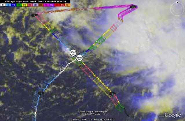
its not really decelerating. It was never moving 16KT this morning
carolina_73 wrote:If the track even slightly shifts west looks as if New England could take a direct hit. It's a good thing Danny is weak and still in slow formation mode. Water temps are VERY HIGH off the EC this season. Danny will have water temps 85+ to work with in the gulfstream. It's even close to 80 off the coast of NE for crying out loud. Danny should have a nice window Thursday and Friday to ramp up. Once it hits those waters i have a feeling the W side of Danny will start to ramp up. I do worry with the right situation in place the EC could get a real nasty intensifying cane later this season. Waters off the EC haven't been disturbed in a very long time and it's not even near the peak.


Derek Ortt wrote:artist wrote:Derek, et al can you explain what it means be decelerating? Are they talking about his forward speed?
its not really decelerating. It was never moving 16KT this morning


Derek Ortt wrote:look for further east shifts in the tracks as the center reforms.
If this does make a landfall, probably Canada and quite possibly Newfoundland


jpigott wrote:question for the pro-mets
if Danny remains a sheared mess and doesn't get its act together, will the low level circulation be more inclined to move WNWrd and not as influenced by the steering currents that are forecasted to move him NW-N

Users browsing this forum: No registered users and 25 guests


