ATL: TROPICAL DEPRESSION HENRI (10L)

Moderator: S2k Moderators

Message
Author
User avatar
DESTRUCTION5
Category 5
Category 5
Posts: 4391
Age: 42
Joined: Wed Sep 03, 2003 11:25 am
Location: Stuart, FL

Re: Re:

#121 Postby DESTRUCTION5 » Mon Oct 05, 2009 6:20 pm

I think that most, if not all, of the S2K members in the NE Caribbean who are very concerned about a potential impact would not say that a disturbance becoming better organized with a greater chance of developing into a life-threatening tropical cyclone is "looking good".[/quote]

The bolded and italicized part of your statement is what "looking good" means.

I know all about the fact that this could endanger people's lives and everything.[/quote]

And how in the world is that "looking good"? You might consider just stating that it looks better organized without making an opinion as to whether it looks good or not. My clients tell me that I've had that problem in the past, saying that a disturbance is "looking better today" or "looking more promising" when that's certainly not good for them. We have to control our enthusiasm when lives are at stake.[/quote]

Jeez you'd think with 7 named storms this year you would have had enough time to get them bike rides in... :wink:
0 likes   
GATOR NATION IS E V E R Y W H E R E !

User avatar
cycloneye
Admin
Admin
Posts: 139602
Age: 67
Joined: Thu Oct 10, 2002 10:54 am
Location: San Juan, Puerto Rico

Re: ATL: Invest 91L - Models

#122 Postby cycloneye » Mon Oct 05, 2009 6:20 pm

18z GFDL gives more life to 91L.And as the Bams do,GFDL bends west or even WSW after moving WNW.

CHGQLM
ATTENTION...NATIONAL HURRICANE CENTER

NCEP COUPLED GFDL HURRICANE MODEL FORECAST MADE FOR

TROPICAL DEPRESSION INVEST 91L

INITIAL TIME 18Z OCT 5

DISCLAIMER ... THIS INFORMATION IS PROVIDED AS GUIDANCE. IT
REQUIRES INTERPRETATION BY HURRICANE SPECIALISTS AND SHOULD
NOT BE CONSIDERED AS A FINAL PRODUCT. PLEASE SEE THE TPC/NHC
OFFICIAL FORECAST.


FORECAST STORM POSITION

HOUR LATITUDE LONGITUDE HEADING/SPEED(KT)

0 13.4 46.8 305./14.0
6 14.4 48.2 307./17.3
12 14.9 49.9 284./17.5
18 15.8 51.9 295./21.2
24 16.3 53.4 289./15.3
30 16.8 55.0 288./15.8
36 17.4 56.7 290./17.3
42 18.5 58.2 303./17.8
48 18.2 60.1 262./18.4

STORM DISSIPATED AT 48 HRS AT THE ABOVE PSN.
0 likes   
Visit the Caribbean-Central America Weather Thread where you can find at first post web cams,radars
and observations from Caribbean basin members Click Here

Brent
S2K Supporter
S2K Supporter
Posts: 37143
Age: 35
Joined: Sun May 16, 2004 10:30 pm
Location: Tulsa Oklahoma
Contact:

Re: Re:

#123 Postby Brent » Mon Oct 05, 2009 6:22 pm

DESTRUCTION5 wrote:Jeez you'd think with 7 named storms this year you would have had enough time to get them bike rides in... :wink:


:clap: :notworthy:
0 likes   
#neversummer

User avatar
cycloneye
Admin
Admin
Posts: 139602
Age: 67
Joined: Thu Oct 10, 2002 10:54 am
Location: San Juan, Puerto Rico

Re: ATL : INVEST 91L

#124 Postby cycloneye » Mon Oct 05, 2009 6:24 pm

Ok,lets return to the topic of the thread.
0 likes   
Visit the Caribbean-Central America Weather Thread where you can find at first post web cams,radars
and observations from Caribbean basin members Click Here

User avatar
HURAKAN
Professional-Met
Professional-Met
Posts: 46086
Age: 37
Joined: Thu May 20, 2004 4:34 pm
Location: Key West, FL
Contact:

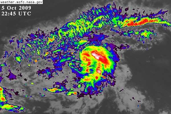
#125 Postby HURAKAN » Mon Oct 05, 2009 6:25 pm

Image

Continues to organize
0 likes   

User avatar
Gustywind
Category 5
Category 5
Posts: 12334
Joined: Mon Sep 03, 2007 7:29 am
Location: Baie-Mahault, GUADELOUPE

Re: ATL: Invest 91L - Models

#126 Postby Gustywind » Mon Oct 05, 2009 6:29 pm

cycloneye wrote:18z GFDL gives more life to 91L.And as the Bams do,GFDL bends west or even WSW after moving WNW.

CHGQLM
ATTENTION...NATIONAL HURRICANE CENTER

NCEP COUPLED GFDL HURRICANE MODEL FORECAST MADE FOR

TROPICAL DEPRESSION INVEST 91L

INITIAL TIME 18Z OCT 5

DISCLAIMER ... THIS INFORMATION IS PROVIDED AS GUIDANCE. IT
REQUIRES INTERPRETATION BY HURRICANE SPECIALISTS AND SHOULD
NOT BE CONSIDERED AS A FINAL PRODUCT. PLEASE SEE THE TPC/NHC
OFFICIAL FORECAST.


FORECAST STORM POSITION

HOUR LATITUDE LONGITUDE HEADING/SPEED(KT)

0 13.4 46.8 305./14.0
6 14.4 48.2 307./17.3
12 14.9 49.9 284./17.5
18 15.8 51.9 295./21.2
24 16.3 53.4 289./15.3
30 16.8 55.0 288./15.8
36 17.4 56.7 290./17.3
42 18.5 58.2 303./17.8
48 18.2 60.1 262./18.4

STORM DISSIPATED AT 48 HRS AT THE ABOVE PSN.

Looks like, maybe? a prononced ridging trend at the end of the forecast period? We shall see, way to early to have the answer, but let's wait and see...as 91L could eventually churn near the NE Leewards.
0 likes   

User avatar
Gustywind
Category 5
Category 5
Posts: 12334
Joined: Mon Sep 03, 2007 7:29 am
Location: Baie-Mahault, GUADELOUPE

#127 Postby Gustywind » Mon Oct 05, 2009 6:33 pm

Image
0 likes   

Derek Ortt

#128 Postby Derek Ortt » Mon Oct 05, 2009 6:33 pm

if it develops quickly, this likely moves out to sea, like NOGAPS was predicting yesterday
0 likes   

User avatar
Gustywind
Category 5
Category 5
Posts: 12334
Joined: Mon Sep 03, 2007 7:29 am
Location: Baie-Mahault, GUADELOUPE

#129 Postby Gustywind » Mon Oct 05, 2009 6:37 pm

Tom Moore, Lead Meteorologist, The Weather Channel
Oct. 5, 2009 4:50 pm ET

A tropical wave located about 950 miles east of the Lesser Antilles has a small area of low pressure associated with it. Shower and thunderstorm activity continues to flare around this feature. Environmental conditions are favorable for some slow development over the next day or two as it moves west-northwest near 15 mph. Should the system develop significantly it would be pulled northward toward the central Atlantic where it would encounter stronger shearing winds. Those winds would likely rip the system apart northeast of the Lesser Antilles. If the system remains weak it would continue west-northwest spreading showers and thunderstorms into the islands later Wednesday and Thursday.
0 likes   

User avatar
boca
Category 5
Category 5
Posts: 6306
Age: 59
Joined: Mon Dec 15, 2003 8:49 am
Location: Boca Raton,FL

Re: ATL : INVEST 91L

#130 Postby boca » Mon Oct 05, 2009 6:42 pm

This looks like it would turn north before the high pressure builds in to keep it west.This system is just following the rest of the storms that formed this year.The shear will eat this storm up if it does organize more quickly too once it turns north.
0 likes   

User avatar
cycloneye
Admin
Admin
Posts: 139602
Age: 67
Joined: Thu Oct 10, 2002 10:54 am
Location: San Juan, Puerto Rico

Re: ATL : INVEST 91L

#131 Postby cycloneye » Mon Oct 05, 2009 6:42 pm

Code Orange

ABNT20 KNHC 052342
TWOAT
TROPICAL WEATHER OUTLOOK
NWS TPC/NATIONAL HURRICANE CENTER MIAMI FL
800 PM EDT MON OCT 5 2009

FOR THE NORTH ATLANTIC...CARIBBEAN SEA AND THE GULF OF MEXICO...

THE NATIONAL HURRICANE CENTER IS ISSUING ADVISORIES ON TROPICAL
STORM GRACE...LOCATED SEVERAL HUNDRED MILES SOUTHWEST OF THE
SOUTHWESTERN COAST OF IRELAND.

A BROAD AREA OF LOW PRESSURE LOCATED ABOUT 875 MILES EAST OF THE
LESSER ANTILLES IS MOVING WEST-NORTHWESTWARD AT ABOUT 15 MPH. THE
ASSOCIATED SHOWER AND THUNDERSTORM ACTIVITY HAS BECOME A LITTLE
BETTER ORGANIZED THIS EVENING AND THIS SYSTEM HAS THE POTENTIAL TO
BECOME A TROPICAL DEPRESSION DURING THE NEXT DAY OR SO BEFORE
UPPER-LEVEL WINDS BECOME LESS FAVORABLE FOR DEVELOPMENT. THERE IS
A MEDIUM CHANCE...30 TO 50 PERCENT...OF THIS SYSTEM BECOMING A
TROPICAL CYCLONE DURING THE NEXT 48 HOURS.

ELSEWHERE...TROPICAL CYCLONE FORMATION IS NOT EXPECTED DURING THE
NEXT 48 HOURS.

PUBLIC ADVISORIES ON GRACE ARE ISSUED UNDER WMO HEADER WTNT34 KNHC
AND UNDER AWIPS HEADER MIATCPAT4. FORECAST/ADVISORIES ON GRACE ARE
ISSUED UNDER WMO HEADER WTNT24 KNHC AND UNDER AWIPS HEADER
MIATCMAT4.

$$
FORECASTER BROWN/ROBERTS

Image
0 likes   
Visit the Caribbean-Central America Weather Thread where you can find at first post web cams,radars
and observations from Caribbean basin members Click Here

User avatar
Blown Away
S2K Supporter
S2K Supporter
Posts: 9874
Joined: Wed May 26, 2004 6:17 am

Re: ATL : INVEST 91L

#132 Postby Blown Away » Mon Oct 05, 2009 6:45 pm

Can somebody post a shear map. Thanks.
0 likes   
Hurricane Eye Experience: David 79, Irene 99, Frances 04, Jeanne 04, Wilma 05... EYE COMING MY WAY IN 2024…
Hurricane Brush Experience: Andrew 92, Erin 95, Floyd 99, Matthew 16, Irma 17, Ian 22, Nicole 22…

User avatar
expat2carib
S2K Supporter
S2K Supporter
Posts: 458
Joined: Tue Jul 22, 2008 1:44 pm
Location: Sint Maarten

Re: Re:

#133 Postby expat2carib » Mon Oct 05, 2009 6:47 pm

Blown_away wrote:
I think that most, if not all, of the S2K members in the NE Caribbean who are very concerned about a potential impact would not say that a disturbance becoming better organized with a greater chance of developing into a life-threatening tropical cyclone is "looking good


And how in the world is that "looking good"? You might consider just stating that it looks better organized without making an opinion as to whether it looks good or not. My clients tell me that I've had that problem in the past, saying that a disturbance is "looking better today" or "looking more promising" when that's certainly not good for them. We have to control our enthusiasm when lives are at stake.


Wrong, Storm2k is not your clients and this is not an official forecast. This is a group of folks who love hurricanes, stop w/ the politically correct nonsense! Anybody that lives in the islands should not be offended by a post saying an invest is "looking good", on a tropical weather discussion board, give me a break! Wxman loosen up!!!


I support wxman 100% . It's not ONLY weather freaks out here on the board. Look at some of the typhoon posts, posted in the last few hours. Some people are, more or less, panicking of what could happen with them and their loved ones.

A system can be looking good for....... who, what, where? I agree then it's better to state "it's better organized". Then the heavy weather freaks know it's WOWWW time and the ones in the path know it's time to be on alert.

Just my opinion.
0 likes   

User avatar
Blown Away
S2K Supporter
S2K Supporter
Posts: 9874
Joined: Wed May 26, 2004 6:17 am

Re: ATL : INVEST 91L

#134 Postby Blown Away » Mon Oct 05, 2009 6:57 pm

:eek:
Last edited by Blown Away on Tue Oct 06, 2009 8:56 am, edited 2 times in total.
0 likes   
Hurricane Eye Experience: David 79, Irene 99, Frances 04, Jeanne 04, Wilma 05... EYE COMING MY WAY IN 2024…
Hurricane Brush Experience: Andrew 92, Erin 95, Floyd 99, Matthew 16, Irma 17, Ian 22, Nicole 22…

User avatar
wxman57
Moderator-Pro Met
Moderator-Pro Met
Posts: 22506
Age: 66
Joined: Sat Jun 21, 2003 8:06 pm
Location: Houston, TX (southwest)

Re: ATL : INVEST 91L

#135 Postby wxman57 » Mon Oct 05, 2009 6:59 pm

cycloneye wrote:Ok,lets return to the topic of the thread.


I just get tired of the endless rooting for development by some on this board, regardless of the consequences of that development. You'll never see me pulling for something to develop. Sure, it might seem exciting to be threatened by a hurricane - until you're dealing with the aftermath of a direct hit. Members here like MGC probably don't look at hurricanes in the same way after Katrina. Believe me, you don't want to be hit by one.

Ok, that's it on the subject.
0 likes   

Aric Dunn
Category 5
Category 5
Posts: 21228
Age: 41
Joined: Sun Sep 19, 2004 9:58 pm
Location: Ready for the Chase.
Contact:

Re: ATL : INVEST 91L

#136 Postby Aric Dunn » Mon Oct 05, 2009 6:59 pm

some of the latest microwave images.. its showing much improved organization with one clear band wrapping around.. its becoming more lilkely as the hours tick by the we will likely have TD sometime in the morning..
Image
0 likes   

User avatar
HurricaneMaster_PR
Category 2
Category 2
Posts: 795
Joined: Tue Jul 22, 2003 6:23 pm
Location: San Juan, Puerto Rico

#137 Postby HurricaneMaster_PR » Mon Oct 05, 2009 7:01 pm

Certainly this system looks good and appears to gradually continue to organize... Can't wait to see the system early in the morning to see if the trend continues...
0 likes   

User avatar
Blown Away
S2K Supporter
S2K Supporter
Posts: 9874
Joined: Wed May 26, 2004 6:17 am

Re: ATL : INVEST 91L

#138 Postby Blown Away » Mon Oct 05, 2009 7:09 pm

wxman57 wrote:
cycloneye wrote:Ok,lets return to the topic of the thread.


I just get tired of the endless rooting for development by some on this board, regardless of the consequences of that development. You'll never see me pulling for something to develop. Sure, it might seem exciting to be threatened by a hurricane - until you're dealing with the aftermath of a direct hit. Members here like MGC probably don't look at hurricanes in the same way after Katrina. Believe me, you don't want to be hit by one.

Ok, that's it on the subject.


Do you forget this is a tropical weather discussion board? You think a post saying 91L is "looking good" now compared this morning is not being sensitive to the island folks? Tell me, what is the point of this forum if we can't post observations about a system? Rooting no, posting observations on an improving invest, yes. Wxman, I appreciate every post you make but you are being way to sensitive. It's all good! :D
0 likes   
Hurricane Eye Experience: David 79, Irene 99, Frances 04, Jeanne 04, Wilma 05... EYE COMING MY WAY IN 2024…
Hurricane Brush Experience: Andrew 92, Erin 95, Floyd 99, Matthew 16, Irma 17, Ian 22, Nicole 22…

Dianmu
Tropical Low
Tropical Low
Posts: 16
Joined: Mon Oct 05, 2009 7:55 am

Re: ATL : INVEST 91L

#139 Postby Dianmu » Mon Oct 05, 2009 7:11 pm

medium 30kts
Image
0 likes   

User avatar
expat2carib
S2K Supporter
S2K Supporter
Posts: 458
Joined: Tue Jul 22, 2008 1:44 pm
Location: Sint Maarten

Re: ATL : INVEST 91L

#140 Postby expat2carib » Mon Oct 05, 2009 7:12 pm

Blown_away wrote:expat2carib

Nobody should be getting official info from Storm2k and I can't believe anybody would be offended from somebody posting that a wave is "looking good", especially from Hurakan. No offense intended, but some of you folks in the islands can be so uptight. :D


It's just a question of communication. I'm not offended at all. It's my empathy with others that will make me choosing my words more careful. I can see the beauty as well. And BTW I know Hurakan is one of the backbones of s2k and I appreciate his work very much. But let's get real.... if one can't criticize, where will we end then?

Back to the topic.
0 likes   


Return to “2009”

Who is online

Users browsing this forum: No registered users and 11 guests