WPAC : TROPICAL DEPRESSION MIRINAE (23W)
Moderator: S2k Moderators

Re: WPAC : TYPHOON MIRINAE (23W) PAGASA=TYPHOON SANTI
I got in ok just now, but I was having problems getting on, earlier this morning.
0 likes
-
cycloneye

- Admin

- Posts: 149841
- Age: 69
- Joined: Thu Oct 10, 2002 10:54 am
- Location: San Juan, Puerto Rico
Re: WPAC : TYPHOON MIRINAE (23W) PAGASA=TYPHOON SANTI
ozonepete wrote:Hey Hurakan, cycloneye, what happened to the Navy site? I'm trying to find the satellite/microwave page and I can't get to it. Anyone know what's going on?
Same here as you as I cant get the latest microwave pic.
0 likes
Visit the Caribbean-Central America Weather Thread where you can find at first post web cams,radars
and observations from Caribbean basin members Click Here
and observations from Caribbean basin members Click Here
Re: WPAC : TYPHOON MIRINAE (23W) PAGASA=TYPHOON SANTI
OK - you're getting to the site - yes, no current image, though... they may be having problems
as I couldn't access the site earlier.
Sorry for the "duh" on my part...
as I couldn't access the site earlier.
Sorry for the "duh" on my part...
0 likes
-
cycloneye
- Admin
- Posts: 149841
- Age: 69
- Joined: Thu Oct 10, 2002 10:54 am
- Location: San Juan, Puerto Rico
Re: WPAC : TYPHOON MIRINAE (23W) PAGASA=TYPHOON SANTI
Here is the latest news from Manila.It appears that they are preparing well ahead of the landfall.
http://www.msnbc.msn.com/id/33533340/ns/weather/
http://www.msnbc.msn.com/id/33533340/ns/weather/
MANILA - Nearly 150 army trucks loaded with food, water and relief goods rolled out to areas in the northern Philippines already devastated by floods and landslides as another typhoon bore down on the country.
Emergency and rescue teams were also sent to areas directly in the path of Typhoon Mirinae, including major rice-producing provinces north of Manila, said Lt. Col. Ernesto Torres, spokesman for the national disaster agency.
Mirinae, a Category 2 typhoon with maximum center winds of 93 mph, was expected to make landfall late on Friday.
Landslides are expected in the northern mountain regions, where several villages were buried by mud early this month during Typhoon Parma.
Two powerful typhoons, Ketsana and Parma, dumped record-high rain that submerged 80 percent of the capital and wide stretches of farmland in the northern provinces, killing more than 900 people and displacing hundreds of thousands.
The typhoons damaged or destroyed nearly $800 million of crops and infrastructure.
0 likes
Visit the Caribbean-Central America Weather Thread where you can find at first post web cams,radars
and observations from Caribbean basin members Click Here
and observations from Caribbean basin members Click Here
-
ozonepete
- Professional-Met

- Posts: 4743
- Joined: Mon Sep 07, 2009 3:23 pm
- Location: From Ozone Park, NYC / Now in Brooklyn, NY
Re: WPAC : TYPHOON MIRINAE (23W) PAGASA=TYPHOON SANTI
OK, thanks guys, I'm able to get in again, although the newest microwaves on Mirinae are still back around 10Z - nothing newer yet.
0 likes
Re: WPAC : TYPHOON MIRINAE (23W) PAGASA=TYPHOON SANTI
Here are some images are from 1730 UTC:
http://cimss.ssec.wisc.edu/tropic/real-time/westpac/images/images.html
http://cimss.ssec.wisc.edu/tropic/real-time/westpac/images/images.html
0 likes
-
cycloneye
- Admin
- Posts: 149841
- Age: 69
- Joined: Thu Oct 10, 2002 10:54 am
- Location: San Juan, Puerto Rico
Re: WPAC : TYPHOON MIRINAE (23W) PAGASA=TYPHOON SANTI
JMA 18 UTC Warning
If I see it right,the track passes the eye over Manila.
TY 0921 (Mirinae)
Issued at 18:45 UTC, 29 October 2009
<Analyses at 29/18 UTC>
Scale -
Intensity Strong
Center position N15°40'(15.7°)
E127°40'(127.7°)
Direction and speed of movement WSW 20km/h(12kt)
Central pressure 960hPa
Maximum wind speed near the center 40m/s(75kt)
Maximum wind gust speed 55m/s(105kt)
Area of 50kt winds or more Wide 110km(60NM)
Area of 30kt winds or more N370km(200NM)
S220km(120NM)
<Forecast for 30/18 UTC>
Intensity Strong
Center position of probability circle N14°50'(14.8°)
E122°55'(122.9°)
Direction and speed of movement W 20km/h(12kt)
Central pressure 960hPa
Maximum wind speed near the center 40m/s(75kt)
Maximum wind gust speed 55m/s(105kt)
Radius of probability circle 140km(75NM)
Storm warning area Wide 240km(130NM)
<Forecast for 31/18 UTC>
Intensity -
Center position of probability circle N14°10'(14.2°)
E117°40'(117.7°)
Direction and speed of movement W 25km/h(13kt)
Central pressure 980hPa
Maximum wind speed near the center 30m/s(55kt)
Maximum wind gust speed 40m/s(80kt)
Radius of probability circle 260km(140NM)
Storm warning area Wide 310km(170NM)
<Forecast for 01/18 UTC>
Intensity -
Center position of probability circle N13°10'(13.2°)
E112°30'(112.5°)
Direction and speed of movement W 25km/h(13kt)
Central pressure 980hPa
Maximum wind speed near the center 30m/s(55kt)
Maximum wind gust speed 40m/s(80kt)
Radius of probability circle 390km(210NM)
Storm warning area Wide 440km(240NM)
0 likes
Visit the Caribbean-Central America Weather Thread where you can find at first post web cams,radars
and observations from Caribbean basin members Click Here
and observations from Caribbean basin members Click Here
Re: WPAC : TYPHOON MIRINAE (23W) PAGASA=TYPHOON SANTI
I'm seeing what you're seeing, Luis - it certainly appears to be right over Manila.
0 likes
-
ozonepete
- Professional-Met
- Posts: 4743
- Joined: Mon Sep 07, 2009 3:23 pm
- Location: From Ozone Park, NYC / Now in Brooklyn, NY
Re: WPAC : TYPHOON MIRINAE (23W) PAGASA=TYPHOON SANTI
breeze wrote:I'm seeing what you're seeing, Luis - it certainly appears to be right over Manila.
Yes, Luis, that's right over Manila.
0 likes
-
cycloneye
- Admin
- Posts: 149841
- Age: 69
- Joined: Thu Oct 10, 2002 10:54 am
- Location: San Juan, Puerto Rico
Re: WPAC : TYPHOON MIRINAE (23W) PAGASA=TYPHOON SANTI
0 likes
Visit the Caribbean-Central America Weather Thread where you can find at first post web cams,radars
and observations from Caribbean basin members Click Here
and observations from Caribbean basin members Click Here
-
ozonepete
- Professional-Met
- Posts: 4743
- Joined: Mon Sep 07, 2009 3:23 pm
- Location: From Ozone Park, NYC / Now in Brooklyn, NY
Re: WPAC : TYPHOON MIRINAE (23W) PAGASA=TYPHOON SANTI
breeze wrote:Here are some images are from 1730 UTC:
http://cimss.ssec.wisc.edu/tropic/real-time/westpac/images/images.html
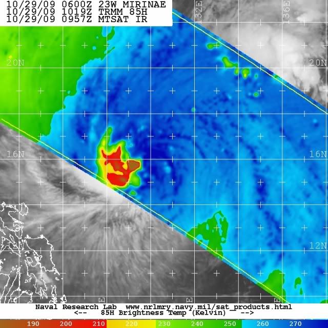
Thanks, breeze. I see JMA is at 75 knots and that seems quite right to me. Mirinae still does not exhibit an eye on conventional satellite so it couldn't be much more than that. I personally think this has never gotten to 90 knots for more than a few hours here and there and is definitely not now. Lots of impressive convection (great CDO) but no eye visible on conventional satellite. Also, here's a microwave from this morning where you can see the convection pushed away towards the west from the LLC - that has definitely helped prevent a complete, well-stacked, clear eye from forming.
0 likes
-
ozonepete
- Professional-Met
- Posts: 4743
- Joined: Mon Sep 07, 2009 3:23 pm
- Location: From Ozone Park, NYC / Now in Brooklyn, NY
Re: WPAC : TYPHOON MIRINAE (23W) PAGASA=TYPHOON SANTI
cycloneye wrote::uarrow: Oh boy,when our friends there wake up and see that track.
Exactly. They are going to freak out. Luckily, this one can't seem to get past 75 knots or so. Hopefully it will stay that way.
0 likes
-
cycloneye
- Admin
- Posts: 149841
- Age: 69
- Joined: Thu Oct 10, 2002 10:54 am
- Location: San Juan, Puerto Rico
Re: WPAC : TYPHOON MIRINAE (23W) PAGASA=TYPHOON SANTI
While we wait for the 18:00Z Warning by JTWC.here is the Prognostic Reasoning from the 12:00Z Warning.
WDPN32 PGTW 291500
MSGID/GENADMIN/NAVMARFCSTCEN PEARL HARBOR HI/JTWC//
SUBJ/PROGNOSTIC REASONING FOR TYPHOON 23W (MIRINAE) WARNING NR 15//
RMKS/
1. FOR METEOROLOGISTS.
2. 12 HOUR SUMMARY AND ANALYSIS.
A. TYPHOON (TY) 23W (MIRINAE) HAS MAINTAINED ITS INTENSITY AS IT
TRACKED WESTWARD UNDER THE INFLUENCE OF THE SUBTROPICAL STEERING
RIDGE TO THE NORTH. RECENT ANIMATED INFRARED IMAGERY SHOWS THE SYSTEM
HAS REGAINED THE DEEP CONVECTION THAT APPEARED TO HAVE DIMINISHED
DURING THE FIRST SIX HOURS OF THIS 12-HOUR OBSERVATION. THE CURRENT
POSITION IS BASED ON ANIMATED INFRARED IMAGERY AND EXTRAPOLATED FROM
A 291019Z MICROWAVE PASS. THE CURRENT INTENSITY IS BASED FROM A
DVORAK CI ESTIMATE OF T5.O FROM PGTW AND RJTD. UPPER LEVEL ANALYSIS
INDICATES THE SYSTEM STILL HAS GOOD POLEWARD OUTFLOW INTO THE
MID-LATITUDE WESTERLIES AND RADIAL OUTFLOW FROM ITS MESOSCALE
ANTICYCLONE. TY 23W IS JUST SOUTH OF THE RIDGE AXIS IN AN AREA OF
LIGHT TO MODERATE VERTICAL WIND SHEAR. ADDITIONALLY, ALONG-TRACK SEA
SURFACE TEMPERATURES ARE IN EXCESS OF 28 DEGREES CELSIUS.
3. FORECAST REASONING.
A. THE FORECAST REASONING HAS NOT CHANGED SINCE THE PREVIOUS
PROGNOSTIC REASONING BULLETIN.
B. THE TYPHOON WILL CONTINUE TO TRACK WESTWARD THROUGH THE
FORECAST PERIOD AND WILL RETAIN GOOD RADIAL OUTFLOW AS IT TRACKS
SOUTH OF THE STEERING RIDGE DESCRIBED IN PARA 2.A. FURTHER
INTENSIFICATION IS UNLIKELY, MAINLY DUE TO THE DIMINISHING POLEWARD
OUTFLOW AS THE SYSTEM TRACKS FURTHER AWAY FROM THE STRONG WESTERLIES.
TY 23W IS EXPECTED TO MAKE LANDFALL IN CENTRAL LUZON NEAR TAU 36. ITS
INTERACTION WITH THE ISLAND'S TOPOGRAPHY WILL NOT SIGNIFICANTLY ERODE
THE SYSTEM AS IT IS NOT EXPECTED TO SLOW DOWN THROUGH THE ISLAND.
MIRINAE IS EXPECTED TO EMERGE IN THE SOUTH CHINA SEA BEFORE TAU 48
AND RESUME A WESTWARD TRACK TOWARDS CENTRAL VIETNAM.
C. DUE TO INCREASING VERTICAL WIND SHEAR, DIMINISHED POLEWARD
EXHAUST, AND A COOLER POOL OF SEA SURFACE TEMPERATURES IN THE CENTRAL
SOUTH CHINA SEA, TY 23W WILL GRADUALLY WEAKEN BEFORE IT MAKES
LANDFALL INTO CENTRAL VIETNAM BEFORE TAU 96. THE MODEL GUIDANCE IS IN
STRONG AGREEMENT WITH THIS FORECAST SCENARIO WITH WBAR REMAINING AS
THE SOLE OUTLIER TO THE RIGHT OF THE ENVELOPE.//
NNNN
0 likes
Visit the Caribbean-Central America Weather Thread where you can find at first post web cams,radars
and observations from Caribbean basin members Click Here
and observations from Caribbean basin members Click Here
Re: WPAC : TYPHOON MIRINAE (23W) PAGASA=TYPHOON SANTI
"Further intensification is not likely" - thank goodness. Our friends have had
way over their share of problems, already!
way over their share of problems, already!
0 likes
-
ManilaTC

- WesternPacificWeather.com

- Posts: 593
- Age: 47
- Joined: Mon Oct 26, 2009 5:13 am
- Location: Mandaluyong City, Philippines
- Contact:
Re: WPAC : TYPHOON MIRINAE (23W) PAGASA=TYPHOON SANTI
Good afternoon to our friends in the west...
OMG... Its clearly a direct hit!
OMG... Its clearly a direct hit!
0 likes
The above post is NOT official and should not be used as such. It is my opinion and may or may not be backed by sound meteorological data. It is not endorsed by any professional institution or storm2k.org. Please refer to your official national weather agency.
WEB http://goo.gl/JDiKXB | FB https://goo.gl/N5sIle | @ManilaTC
WEB http://goo.gl/JDiKXB | FB https://goo.gl/N5sIle | @ManilaTC
-
ManilaTC
- WesternPacificWeather.com
- Posts: 593
- Age: 47
- Joined: Mon Oct 26, 2009 5:13 am
- Location: Mandaluyong City, Philippines
- Contact:
Re: WPAC : TYPHOON MIRINAE (23W) PAGASA=TYPHOON SANTI
cycloneye wrote::uarrow: Oh boy,when our friends there wake up and see that track.
Its almost 4am here in Manila.
Yeah I really woke up early to check the track and my initial reaction is
0 likes
The above post is NOT official and should not be used as such. It is my opinion and may or may not be backed by sound meteorological data. It is not endorsed by any professional institution or storm2k.org. Please refer to your official national weather agency.
WEB http://goo.gl/JDiKXB | FB https://goo.gl/N5sIle | @ManilaTC
WEB http://goo.gl/JDiKXB | FB https://goo.gl/N5sIle | @ManilaTC
-
Derek Ortt
I'm afraid I have some bad news for those in the Philippines
http://www.nrlmry.navy.mil/tc-bin/tc_ho ... egreeticks
The latest microwave shows that the center/eye is again under the deep convection and is well formed. A very intense southern eyewall is now present
http://www.nrlmry.navy.mil/tc-bin/tc_ho ... egreeticks
The latest microwave shows that the center/eye is again under the deep convection and is well formed. A very intense southern eyewall is now present
0 likes
-
wxmann_91

- Category 5

- Posts: 8007
- Age: 34
- Joined: Fri Jul 15, 2005 2:49 pm
- Location: Southern California
- Contact:
Just a reminder to everyone that it is rain, not the wind, that will cause the most damage. Know this issue has been beaten to death, but there's been quite an emphasis on intensity as of late, and not as much on storm size/speed/overall wetness. Convection is intense so whoever's gonna get the rain is going to get A LOT of it, but at least for now it seems the coverage of the intense rains is relatively small, and the speed of the storm is relatively fast. That may preclude a truly catastrophic event for the Philippines (not saying this is going to be a non-event however), crossing fingers.
0 likes
-
ozonepete
- Professional-Met
- Posts: 4743
- Joined: Mon Sep 07, 2009 3:23 pm
- Location: From Ozone Park, NYC / Now in Brooklyn, NY
Re: WPAC : TYPHOON MIRINAE (23W) PAGASA=TYPHOON SANTI
"TY 23W IS EXPECTED TO MAKE LANDFALL IN CENTRAL LUZON NEAR TAU 36. ITS INTERACTION WITH THE ISLAND'S TOPOGRAPHY WILL NOT SIGNIFICANTLY ERODE THE SYSTEM AS IT IS NOT EXPECTED TO SLOW DOWN THROUGH THE ISLAND. MIRINAE IS EXPECTED TO EMERGE IN THE SOUTH CHINA SEA BEFORE TAU 48 AND RESUME A WESTWARD TRACK TOWARDS CENTRAL VIETNAM. "
Also, the mountains on the central east coast are lower (I believe 2,000 feet or so). They will not disrupt it as badly as the really high mountains (10,000 feet) of northern Luzon would. They will disrupt it, however, to some degree.
Also, the mountains on the central east coast are lower (I believe 2,000 feet or so). They will not disrupt it as badly as the really high mountains (10,000 feet) of northern Luzon would. They will disrupt it, however, to some degree.
0 likes
-
ozonepete
- Professional-Met
- Posts: 4743
- Joined: Mon Sep 07, 2009 3:23 pm
- Location: From Ozone Park, NYC / Now in Brooklyn, NY
Re:
Derek Ortt wrote:I'm afraid I have some bad news for those in the Philippines
http://www.nrlmry.navy.mil/tc-bin/tc_ho ... egreeticks
The latest microwave shows that the center/eye is again under the deep convection and is well formed. A very intense southern eyewall is now present
Yeah, it's stacked vertically again. Let's hope that eyewall doesn't build all the way around. Luckily it's already beginning some land interaction.
0 likes
Who is online
Users browsing this forum: No registered users and 8 guests