WPAC: SEVERE TROPICAL STORM LUPIT (22W)

Moderator: S2k Moderators

Message
Author
oaba09
S2K Supporter
S2K Supporter
Posts: 1496
Age: 37
Joined: Thu Oct 01, 2009 10:02 am
Location: Valenzuela, Philippines
Contact:

Re: Re:

#1021 Postby oaba09 » Thu Oct 22, 2009 8:42 pm

ozonepete wrote:
oaba09 wrote:And I thought Luzon is already spared....I feel bad for the people of aparri...They're not a rich town....I'm sure they're gonna have a tough time recovering....

Jim, has the flooding started???


Hi oaba09,
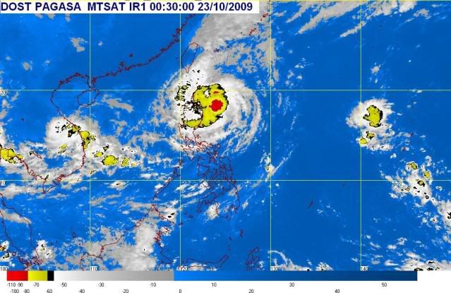
There's no serious condition yet, so please don't worry at this time. Here is your recent satellite from PAGASA. It shows that the rains at Aparri are probably moderate but not heavy. I'm still looking for reports, but so far it looks like they are not doing very badlyl. The really heavy rain and worst conditions are WAY offshore to the east. If conditions really get bad, you will know. Somebody will report it here. But there are no forecasts right now for dire conditions anywhere in Luzon, because this storm is weakening and most likely will start moving away within 24 hours. That's the consensus at this time anyway. Hang in there.

Image


Thanks for the info...I just can't help it because most of the livelihood in aparri involves fishing or farming....we all know how typhoons can affect those industries...
0 likes   

I-wall
Tropical Storm
Tropical Storm
Posts: 210
Joined: Wed Sep 10, 2008 5:24 pm

Re: WPAC: TYPHOON LUPIT (22W)

#1022 Postby I-wall » Thu Oct 22, 2009 8:47 pm

JTE50 wrote:
ozonepete wrote:Too bad I can't post images, but just go look at the loops. LUPIT is on the move; it is clearly recurving around the eastern STR now and should start accelerating north or northeastward within the next few hours. This could really start moving fast soon from the looks of it.

HEADS UP, Jim! Some really heavy rain squalls headed for Appari.


During the night rain dripped in from the ceiling onto a table with my video and still cams. They are all wet now. The laptop is ok. I am dead in the water until I can find a blow dryer and hopefully get the cams dried out if they even work. There's water all over my 5K HD Cam. You can't win at this- you get the gear off the floor so flooding won't be a problem but then it comes in from the ceiling. Sheesh! Next time I put everything in a huge zip lock.

That sucks man. Sorry to hear that. Be safe up there, and we look forward to any observations you report.
0 likes   

User avatar
cycloneye
Admin
Admin
Posts: 139593
Age: 67
Joined: Thu Oct 10, 2002 10:54 am
Location: San Juan, Puerto Rico

Re: WPAC: TYPHOON LUPIT (22W)

#1023 Postby cycloneye » Thu Oct 22, 2009 8:48 pm

0300z JTWC Warning=Downgraded to Tropical Storm at 60kts

But the title of thread remains as Typhoon because JMA mantained typhoon status.

WTPN31 PGTW 230300
MSGID/GENADMIN/NAVMARFCSTCEN PEARL HARBOR HI/JTWC//
SUBJ/TROPICAL CYCLONE WARNING//
RMKS/
1. TROPICAL STORM 22W (LUPIT) WARNING NR 037
DOWNGRADED FROM TYPHOON 22W
01 ACTIVE TROPICAL CYCLONE IN NORTHWESTPAC
MAX SUSTAINED WINDS BASED ON ONE-MINUTE AVERAGE
WIND RADII VALID OVER OPEN WATER ONLY
---
WARNING POSITION:
230000Z --- NEAR 18.9N 123.4E
MOVEMENT PAST SIX HOURS - 270 DEGREES AT 03 KTS
POSITION ACCURATE TO WITHIN 040 NM
POSITION BASED ON CENTER LOCATED BY SATELLITE
PRESENT WIND DISTRIBUTION:
MAX SUSTAINED WINDS - 060 KT, GUSTS 075 KT
WIND RADII VALID OVER OPEN WATER ONLY
RADIUS OF 050 KT WINDS - 075 NM NORTHEAST QUADRANT
055 NM SOUTHEAST QUADRANT
060 NM SOUTHWEST QUADRANT
075 NM NORTHWEST QUADRANT
RADIUS OF 034 KT WINDS - 145 NM NORTHEAST QUADRANT
145 NM SOUTHEAST QUADRANT
135 NM SOUTHWEST QUADRANT
135 NM NORTHWEST QUADRANT
REPEAT POSIT: 18.9N 123.4E
---
FORECASTS:
12 HRS, VALID AT:
231200Z --- 19.0N 123.1E
MAX SUSTAINED WINDS - 060 KT, GUSTS 075 KT
WIND RADII VALID OVER OPEN WATER ONLY
RADIUS OF 050 KT WINDS - 050 NM NORTHEAST QUADRANT
040 NM SOUTHEAST QUADRANT
045 NM SOUTHWEST QUADRANT
050 NM NORTHWEST QUADRANT
RADIUS OF 034 KT WINDS - 120 NM NORTHEAST QUADRANT
115 NM SOUTHEAST QUADRANT
110 NM SOUTHWEST QUADRANT
110 NM NORTHWEST QUADRANT
VECTOR TO 24 HR POSIT: 300 DEG/ 01 KTS
---
24 HRS, VALID AT:
240000Z --- 19.1N 122.9E
MAX SUSTAINED WINDS - 055 KT, GUSTS 070 KT
WIND RADII VALID OVER OPEN WATER ONLY
RADIUS OF 050 KT WINDS - 040 NM NORTHEAST QUADRANT
035 NM SOUTHEAST QUADRANT
035 NM SOUTHWEST QUADRANT
035 NM NORTHWEST QUADRANT
RADIUS OF 034 KT WINDS - 105 NM NORTHEAST QUADRANT
100 NM SOUTHEAST QUADRANT
090 NM SOUTHWEST QUADRANT
095 NM NORTHWEST QUADRANT
VECTOR TO 36 HR POSIT: 270 DEG/ 01 KTS
---
36 HRS, VALID AT:
241200Z --- 19.1N 122.7E
MAX SUSTAINED WINDS - 055 KT, GUSTS 070 KT
WIND RADII VALID OVER OPEN WATER ONLY
RADIUS OF 050 KT WINDS - 025 NM NORTHEAST QUADRANT
025 NM SOUTHEAST QUADRANT
025 NM SOUTHWEST QUADRANT
025 NM NORTHWEST QUADRANT
RADIUS OF 034 KT WINDS - 100 NM NORTHEAST QUADRANT
095 NM SOUTHEAST QUADRANT
085 NM SOUTHWEST QUADRANT
090 NM NORTHWEST QUADRANT
VECTOR TO 48 HR POSIT: 270 DEG/ 01 KTS
---
EXTENDED OUTLOOK:
48 HRS, VALID AT:
250000Z --- 19.1N 122.5E
MAX SUSTAINED WINDS - 050 KT, GUSTS 065 KT
WIND RADII VALID OVER OPEN WATER ONLY
RADIUS OF 034 KT WINDS - 080 NM NORTHEAST QUADRANT
080 NM SOUTHEAST QUADRANT
070 NM SOUTHWEST QUADRANT
070 NM NORTHWEST QUADRANT
VECTOR TO 72 HR POSIT: 290 DEG/ 01 KTS
---
72 HRS, VALID AT:
260000Z --- 19.2N 122.2E
MAX SUSTAINED WINDS - 050 KT, GUSTS 065 KT
WIND RADII VALID OVER OPEN WATER ONLY
RADIUS OF 034 KT WINDS - 075 NM NORTHEAST QUADRANT
075 NM SOUTHEAST QUADRANT
065 NM SOUTHWEST QUADRANT
065 NM NORTHWEST QUADRANT
VECTOR TO 96 HR POSIT: 315 DEG/ 01 KTS
---
LONG RANGE OUTLOOK:
NOTE...ERRORS FOR TRACK HAVE AVERAGED NEAR 250 NM
ON DAY 4 AND 350 NM ON DAY 5... AND FOR INTENSITY
NEAR 20 KT EACH DAY.
---
96 HRS, VALID AT:
270000Z --- 19.5N 121.9E
MAX SUSTAINED WINDS - 045 KT, GUSTS 055 KT
WIND RADII VALID OVER OPEN WATER ONLY
VECTOR TO 120 HR POSIT: 330 DEG/ 01 KTS
---
120 HRS, VALID AT:
280000Z --- 20.0N 121.6E
MAX SUSTAINED WINDS - 045 KT, GUSTS 055 KT
WIND RADII VALID OVER OPEN WATER ONLY
---
REMARKS:
230300Z POSITION NEAR 18.9N 123.3E. TROPICAL STORM (TS) 22W (LUPIT),
LOCATED APPROXIMATELY 285 NM NORTH-NORTHEAST OF MANILA, PHILIPPINES,
HAS TRACKED WESTWARD AT 03 KNOTS OVER THE PAST SIX HOURS. THE SYSTEM
REMAINS IN A WEAK STEERING ENVIRONMENT WITH ERRATIC MODEL GUIDANCE.
THE SYSTEM CONTINUES TO WEAKEN DUE TO DRY AIR ENTRAINMENT AND
INTERACTION FROM LAND AND HAS BEEN DOWNGRADED TO A TROPICAL STORM.
MAXIMUM SIGNIFICANT WAVE HEIGHT AT 230000Z IS 31 FEET. NEXT WARNINGS
AT 230900Z, 231500Z, 232100Z AND 240300Z.//
NNNN

Image
0 likes   
Visit the Caribbean-Central America Weather Thread where you can find at first post web cams,radars
and observations from Caribbean basin members Click Here

User avatar
breeze
Category 5
Category 5
Posts: 9110
Age: 61
Joined: Sat Feb 08, 2003 4:55 pm
Location: Lawrenceburg, TN

Re: WPAC: TYPHOON LUPIT (22W)

#1024 Postby breeze » Thu Oct 22, 2009 8:51 pm

Aparri, Philippines (Airport)
Updated: 9:00 AM PHT on October 23, 2009
Light Rain
79 °F
Light Rain
Humidity: 89%
Dew Point: 76 °F
Wind: 18 mph from the NW
Wind Gust: -
Pressure: 29.62 in
Visibility: 6.0 miles
UV: 3 out of 16
Clouds:
Mostly Cloudy 1772 ft
Overcast 7874 ft
(Above Ground Level)
Elevation: 7 ft

http://www.wunderground.com/global/stations/98232.html
0 likes   

ozonepete
Professional-Met
Professional-Met
Posts: 4743
Joined: Mon Sep 07, 2009 3:23 pm
Location: From Ozone Park, NYC / Now in Brooklyn, NY

Re: WPAC: TYPHOON LUPIT (22W)

#1025 Postby ozonepete » Thu Oct 22, 2009 9:01 pm

:uarrow: So far so good. Especially because the satellite images from a few hours ago appear to be worse than what's actually happening. At least we hope that's what's happening.
0 likes   

ozonepete
Professional-Met
Professional-Met
Posts: 4743
Joined: Mon Sep 07, 2009 3:23 pm
Location: From Ozone Park, NYC / Now in Brooklyn, NY

Re: WPAC: TYPHOON LUPIT (22W)

#1026 Postby ozonepete » Thu Oct 22, 2009 9:14 pm

Direction still looks to be a west drift, and I don't see any recurve happening yet. This has got to be ingesting some serious dry air pretty soon. But luckily the worst convection remains on the east side of it and remains offshore.
0 likes   

oaba09
S2K Supporter
S2K Supporter
Posts: 1496
Age: 37
Joined: Thu Oct 01, 2009 10:02 am
Location: Valenzuela, Philippines
Contact:

Re: WPAC: TYPHOON LUPIT (22W)

#1027 Postby oaba09 » Thu Oct 22, 2009 9:23 pm

ozonepete wrote:Direction still looks to be a west drift, and I don't see any recurve happening yet. This has got to be ingesting some serious dry air pretty soon. But luckily the worst convection remains on the east side of it and remains offshore.


This is one of the most interesting systems I have ever seen...
0 likes   

ozonepete
Professional-Met
Professional-Met
Posts: 4743
Joined: Mon Sep 07, 2009 3:23 pm
Location: From Ozone Park, NYC / Now in Brooklyn, NY

Re: WPAC: TYPHOON LUPIT (22W)

#1028 Postby ozonepete » Thu Oct 22, 2009 9:32 pm

Jim,
Although I'm sure you probably know this, make sure you take out the battery and flash card and dry them separately. I really hope you got to dry them out ok, and most important, of course, stay safe, especially if you're still over there by the ocean. Good luck.
0 likes   

User avatar
metenthusiast
Category 1
Category 1
Posts: 271
Age: 46
Joined: Sun Oct 18, 2009 1:09 am
Location: Manila, Phllippines
Contact:

Re: WPAC: TYPHOON LUPIT (22W)

#1029 Postby metenthusiast » Thu Oct 22, 2009 9:33 pm

oaba09 wrote:
ozonepete wrote:Direction still looks to be a west drift, and I don't see any recurve happening yet. This has got to be ingesting some serious dry air pretty soon. But luckily the worst convection remains on the east side of it and remains offshore.


This is one of the most interesting systems I have ever seen...


Hello guys! Yeah, me too. I've been practically living in a storm-battered country my entire life, but only the recent onslaught of "ondoy" (ketsana) here in Metro Manila whetted my interest in tropical cyclones, and I thought Parma was crazier the way it zigzagged and hovered over the country. But let me tell you, Lupit made me want to study a weather system behavior even more. :D
0 likes   

User avatar
metenthusiast
Category 1
Category 1
Posts: 271
Age: 46
Joined: Sun Oct 18, 2009 1:09 am
Location: Manila, Phllippines
Contact:

Re: WPAC: TYPHOON LUPIT (22W)

#1030 Postby metenthusiast » Thu Oct 22, 2009 9:37 pm

ozonepete wrote:Jim,
Although I'm sure you probably know this, make sure you take out the battery and flash card and dry them separately. I really hope you got to dry them out ok, and most important, of course, stay safe, especially if you're still over there by the ocean. Good luck.


Yeah Jim. Otherwise, the copper conductors would oxidize, short the gadget's system, and deliver more headache to your already frustrating episode. :D
0 likes   

ozonepete
Professional-Met
Professional-Met
Posts: 4743
Joined: Mon Sep 07, 2009 3:23 pm
Location: From Ozone Park, NYC / Now in Brooklyn, NY

Re: WPAC: TYPHOON LUPIT (22W)

#1031 Postby ozonepete » Thu Oct 22, 2009 9:43 pm

Sure is a mess now. Very disorganized. And the weak shortwave from China did NOT catch it. Looks like it will drift towards the gap between Luzon and Taiwan as a weak tropical storm, and doesn't look like it has much of a future after that.
0 likes   

User avatar
metenthusiast
Category 1
Category 1
Posts: 271
Age: 46
Joined: Sun Oct 18, 2009 1:09 am
Location: Manila, Phllippines
Contact:

Re: WPAC: TYPHOON LUPIT (22W)

#1032 Postby metenthusiast » Thu Oct 22, 2009 10:04 pm

ozonepete wrote:Sure is a mess now. Very disorganized. And the weak shortwave from China did NOT catch it. Looks like it will drift towards the gap between Luzon and Taiwan as a weak tropical storm, and doesn't look like it has much of a future after that.


Pity. I really thought early on that this system had so much potential. However, I wonder how would that affect the northern part of the country? I know you said that most of the major rain clouds remains at shore, but wouldn't still carry winds that causes storm surges? The waves caused by those storm surges are what the people up north are afraid of, especially those living in coastal areas.
Last edited by metenthusiast on Fri Oct 23, 2009 8:52 am, edited 1 time in total.
0 likes   

aerology
Tropical Depression
Tropical Depression
Posts: 56
Age: 77
Joined: Sun Oct 18, 2009 2:38 am
Location: Concordia, Kansas
Contact:

Re: WPAC: TYPHOON LUPIT (22W)

#1033 Postby aerology » Thu Oct 22, 2009 10:35 pm

metenthusiast wrote:
ozonepete wrote:Jim,
Although I'm sure you probably know this, make sure you take out the battery and flash card and dry them separately. I really hope you got to dry them out ok, and most important, of course, stay safe, especially if you're still over there by the ocean. Good luck.


Yeah Jim. Otherwise, the copper conductors would oxidize, short the gadget's system, and deliver more headache to your already frustrating episode. :D


If you clean the (disconnected from power) components with 90% rubbing alcohol before blow drying it will prevent salt and mineral deposits, and long term corrosion problems.
0 likes   

ozonepete
Professional-Met
Professional-Met
Posts: 4743
Joined: Mon Sep 07, 2009 3:23 pm
Location: From Ozone Park, NYC / Now in Brooklyn, NY

Re: WPAC: TYPHOON LUPIT (22W)

#1034 Postby ozonepete » Thu Oct 22, 2009 10:40 pm

aerology wrote:
metenthusiast wrote:
ozonepete wrote:Jim,
Although I'm sure you probably know this, make sure you take out the battery and flash card and dry them separately. I really hope you got to dry them out ok, and most important, of course, stay safe, especially if you're still over there by the ocean. Good luck.


Yeah Jim. Otherwise, the copper conductors would oxidize, short the gadget's system, and deliver more headache to your already frustrating episode. :D


If you clean the (disconnected from power) components with 90% rubbing alcohol before blow drying it will prevent salt and mineral deposits, and long term corrosion problems.


Very nice of you to throw that in. I don't know if Jim can get on the internet right now and pick this up, but thanks a lot for helping out.
0 likes   

User avatar
theavocado
Professional-Met
Professional-Met
Posts: 162
Age: 47
Joined: Sun Mar 22, 2009 8:54 pm
Location: NOLA

Re: WPAC: TYPHOON LUPIT (22W)

#1035 Postby theavocado » Thu Oct 22, 2009 10:57 pm

ozonepete wrote:Direction still looks to be a west drift, and I don't see any recurve happening yet. This has got to be ingesting some serious dry air pretty soon. But luckily the worst convection remains on the east side of it and remains offshore.


Makes you wonder what JTWC saw that no one else did. They still haven't fully bit off on the recurve...just 5 days in the Luzon Strait...
0 likes   

User avatar
StormingB81
S2K Supporter
S2K Supporter
Posts: 5676
Age: 42
Joined: Thu Aug 27, 2009 1:45 am
Location: Rockledge, Florida

#1036 Postby StormingB81 » Thu Oct 22, 2009 11:14 pm

Well dont they say it gets weak because it has been in the same water for 2 days now. So it could possibly when it moves can restrangthen once getting into water where it hasnt been. Or am I wrong on this?
0 likes   

User avatar
JTE50
Category 1
Category 1
Posts: 336
Age: 66
Joined: Mon Jul 21, 2008 10:48 am
Location: Pensacola
Contact:

Re: WPAC: TYPHOON LUPIT (22W)

#1037 Postby JTE50 » Fri Oct 23, 2009 12:46 am

theavocado wrote:
ozonepete wrote:Direction still looks to be a west drift, and I don't see any recurve happening yet. This has got to be ingesting some serious dry air pretty soon. But luckily the worst convection remains on the east side of it and remains offshore.


Makes you wonder what JTWC saw that no one else did. They still haven't fully bit off on the recurve...just 5 days in the Luzon Strait...


JTWC has been the best forecast with Lupit no doubt about it. I like their reasoning on one occassion too, when the models were predicting a turn they would note that analysis of the satellite imagery just didn't support it. JMA was bounching all over the place - Northern Luzon, the recure east of Taiwan, then back down to the northern Phil coast. I got dizzy just looking at their maps. My hat's off to JTWC for calling it like they saw it on this very difficult forecast.
0 likes   

User avatar
metenthusiast
Category 1
Category 1
Posts: 271
Age: 46
Joined: Sun Oct 18, 2009 1:09 am
Location: Manila, Phllippines
Contact:

Re: WPAC: TYPHOON LUPIT (22W)

#1038 Postby metenthusiast » Fri Oct 23, 2009 1:07 am

JTE50 wrote:
theavocado wrote:
ozonepete wrote:Direction still looks to be a west drift, and I don't see any recurve happening yet. This has got to be ingesting some serious dry air pretty soon. But luckily the worst convection remains on the east side of it and remains offshore.


Makes you wonder what JTWC saw that no one else did. They still haven't fully bit off on the recurve...just 5 days in the Luzon Strait...


JTWC has been the best forecast with Lupit no doubt about it. I like their reasoning on one occassion too, when the models were predicting a turn they would note that analysis of the satellite imagery just didn't support it. JMA was bounching all over the place - Northern Luzon, the recure east of Taiwan, then back down to the northern Phil coast. I got dizzy just looking at their maps. My hat's off to JTWC for calling it like they saw it on this very difficult forecast.


Yeah, you're right about that. They have been fairly consistent with this storm even when the other agencies went crazy with their models, doing re-curve plots here and there. I guess the true instincts of someone finely attuned to this weather systems shines in storms as hard to predict and anticipate like Lupit.

by the way, Jim, how's the weather there now in Aparri?
0 likes   

User avatar
StormingB81
S2K Supporter
S2K Supporter
Posts: 5676
Age: 42
Joined: Thu Aug 27, 2009 1:45 am
Location: Rockledge, Florida

#1039 Postby StormingB81 » Fri Oct 23, 2009 1:17 am

In the last hour it looks like it may have took a little jump to the north. But the storm looks very disorganized and at this point will be a rain maker more then anything it looks like.

The posts in this forum are NOT official forecast and should not be used as such. They are just the opinion of the poster and may or may not be backed by sound meteorological data. They are NOT endorsed by any professional institution or storm2k.org. For official information, please refer to the NHC and NWS products.
0 likes   

User avatar
metenthusiast
Category 1
Category 1
Posts: 271
Age: 46
Joined: Sun Oct 18, 2009 1:09 am
Location: Manila, Phllippines
Contact:

Re:

#1040 Postby metenthusiast » Fri Oct 23, 2009 1:35 am

StormingB81 wrote:In the last hour it looks like it may have took a little jump to the north. But the storm looks very disorganized and at this point will be a rain maker more then anything it looks like.

The posts in this forum are NOT official forecast and should not be used as such. They are just the opinion of the poster and may or may not be backed by sound meteorological data. They are NOT endorsed by any professional institution or storm2k.org. For official information, please refer to the NHC and NWS products.


I guess that's all right as long as those rain bands stay away from land and dump their load at sea.
0 likes   


Return to “2009”

Who is online

Users browsing this forum: No registered users and 8 guests