ATL : TROPICAL STORM GRACE

Moderator: S2k Moderators

Message
Author
pepeavilenho
Tropical Storm
Tropical Storm
Posts: 170
Joined: Thu Jul 09, 2009 12:01 pm

#101 Postby pepeavilenho » Sun Oct 04, 2009 3:12 pm

Image

Image

help!! where is NHC?

:cold:
0 likes   

User avatar
DanieleItalyRm
Category 1
Category 1
Posts: 486
Age: 38
Joined: Mon Sep 22, 2008 7:52 am
Location: Rome - Italy - Mediterranean sea

#102 Postby DanieleItalyRm » Sun Oct 04, 2009 3:51 pm

NHC no quiere seguir y no dará' nombre a ninguna sistema de Nord/Est Atlantico.
ELLOS QUIEREN CONSERVAR NOMBRE POR SISTEMA DEL TROPIC OR NORTE OWEST ATLANTIC (US), lo ha demostrado muchas veces.
90L no es a L-INVEST, es an EVIDENT TROPICAL STORM.
saludos da Italia
0 likes   

Derek Ortt

#103 Postby Derek Ortt » Sun Oct 04, 2009 3:53 pm

I SUSPECT that when Read took over, there was a change in naming protocol. These systems seemed to have been named in the early part of the decade. Nothing wrong with it, however
0 likes   

pepeavilenho
Tropical Storm
Tropical Storm
Posts: 170
Joined: Thu Jul 09, 2009 12:01 pm

#104 Postby pepeavilenho » Sun Oct 04, 2009 4:15 pm

in spite of NHC, I continue looking the system...

:eek:

Image

Image

Image

8-)
0 likes   

User avatar
DanieleItalyRm
Category 1
Category 1
Posts: 486
Age: 38
Joined: Mon Sep 22, 2008 7:52 am
Location: Rome - Italy - Mediterranean sea

#105 Postby DanieleItalyRm » Sun Oct 04, 2009 5:01 pm

PLEASE guys! this is a very small tropical cyclone! and the wam core many probably extremly small!

Image

Image
0 likes   

User avatar
cycloneye
Admin
Admin
Posts: 139724
Age: 67
Joined: Thu Oct 10, 2002 10:54 am
Location: San Juan, Puerto Rico

Re: ATL : Invest 90L

#106 Postby cycloneye » Sun Oct 04, 2009 5:23 pm

Looking at all the images above and this one,I dont see what caused NHC to not name this as Subtropical Storm.

Image
0 likes   
Visit the Caribbean-Central America Weather Thread where you can find at first post web cams,radars
and observations from Caribbean basin members Click Here

CrazyC83
Professional-Met
Professional-Met
Posts: 33399
Joined: Tue Mar 07, 2006 11:57 pm
Location: Deep South, for the first time!

#107 Postby CrazyC83 » Sun Oct 04, 2009 5:46 pm

That looks more like a tropical storm...
0 likes   

pepeavilenho
Tropical Storm
Tropical Storm
Posts: 170
Joined: Thu Jul 09, 2009 12:01 pm

#108 Postby pepeavilenho » Sun Oct 04, 2009 6:29 pm

argggggggg
when is the next nhc paper???

Image

Image
0 likes   

User avatar
Macrocane
Category 5
Category 5
Posts: 4218
Age: 35
Joined: Sun May 24, 2009 5:35 pm
Location: El Salvador

Re: ATL : Invest 90L

#109 Postby Macrocane » Sun Oct 04, 2009 6:30 pm

It won't be named even if it looks similar to Vince.
0 likes   

User avatar
HURAKAN
Professional-Met
Professional-Met
Posts: 46086
Age: 37
Joined: Thu May 20, 2004 4:34 pm
Location: Key West, FL
Contact:

#110 Postby HURAKAN » Sun Oct 04, 2009 6:36 pm

Image

Image

Graceful,

Get it!!!
0 likes   

leanne_uk
Tropical Storm
Tropical Storm
Posts: 214
Age: 41
Joined: Fri Sep 04, 2009 4:38 pm
Location: Loughborough countryside, Leicestershire, UK

#111 Postby leanne_uk » Sun Oct 04, 2009 6:45 pm

Small but perfectly formed wouldnt you say :)
0 likes   

User avatar
HURAKAN
Professional-Met
Professional-Met
Posts: 46086
Age: 37
Joined: Thu May 20, 2004 4:34 pm
Location: Key West, FL
Contact:

#112 Postby HURAKAN » Sun Oct 04, 2009 6:53 pm

834
ABNT20 KNHC 042352
TWOAT
TROPICAL WEATHER OUTLOOK
NWS TPC/NATIONAL HURRICANE CENTER MIAMI FL
800 PM EDT SUN OCT 4 2009

FOR THE NORTH ATLANTIC...CARIBBEAN SEA AND THE GULF OF MEXICO...

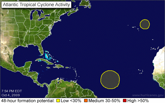
A TROPICAL WAVE LOCATED ABOUT 1200 MILES EAST OF THE WINDWARD
ISLANDS IS PRODUCING A LARGE AREA OF DISORGANIZED SHOWERS AND
THUNDERSTORMS. SOME SLOW DEVELOPMENT OF THIS SYSTEM IS POSSIBLE
OVER THE NEXT COUPLE OF DAYS AS IT MOVES WESTWARD AT 15 TO 20 MPH.
THERE IS A LOW CHANCE...LESS THAN 30 PERCENT...OF THIS SYSTEM
BECOMING A TROPICAL CYCLONE DURING THE NEXT 48 HOURS.

SHOWER ACTIVITY HAS INCREASED NEAR THE CENTER OF A NON-TROPICAL
LOW PRESSURE AREA LOCATED ABOUT 225 MILES NORTHEAST OF THE AZORES
ISLANDS. THIS LOW IS MOVING QUICKLY NORTHEASTWARD TOWARD COOLER
WATERS AND DEVELOPMENT INTO SUBTROPICAL OR TROPICAL CYCLONE IS NOT
LIKELY. THERE IS A LOW CHANCE...LESS THAN 30 PERCENT...OF THIS
SYSTEM BECOMING A SUBTROPICAL OR TROPICAL CYCLONE DURING THE NEXT
48 HOURS.


ELSEWHERE...TROPICAL CYCLONE FORMATION IS NOT EXPECTED DURING THE
NEXT 48 HOURS.

$$
FORECASTER BROWN

Image
0 likes   

CrazyC83
Professional-Met
Professional-Met
Posts: 33399
Joined: Tue Mar 07, 2006 11:57 pm
Location: Deep South, for the first time!

#113 Postby CrazyC83 » Sun Oct 04, 2009 6:55 pm

Remember the famous lines "if it looks like a hurricane, it probably is..."

They've said that for the last 72 hours that cooler waters would kill it...it hasn't!
0 likes   

User avatar
HURAKAN
Professional-Met
Professional-Met
Posts: 46086
Age: 37
Joined: Thu May 20, 2004 4:34 pm
Location: Key West, FL
Contact:

Re:

#114 Postby HURAKAN » Sun Oct 04, 2009 6:57 pm

CrazyC83 wrote:They've said that for the last 72 hours that cooler waters would kill it...it hasn't!


We all know that at some point it will. Incredible!
0 likes   

leanne_uk
Tropical Storm
Tropical Storm
Posts: 214
Age: 41
Joined: Fri Sep 04, 2009 4:38 pm
Location: Loughborough countryside, Leicestershire, UK

#115 Postby leanne_uk » Sun Oct 04, 2009 6:59 pm

Silly question but does anyone know where is this heading?
0 likes   

User avatar
HURAKAN
Professional-Met
Professional-Met
Posts: 46086
Age: 37
Joined: Thu May 20, 2004 4:34 pm
Location: Key West, FL
Contact:

Re:

#116 Postby HURAKAN » Sun Oct 04, 2009 7:00 pm

leanne_uk wrote:Silly question but does anyone know where is this heading?


Cooler waters!!! :lol: :lol: :lol:
0 likes   

User avatar
cycloneye
Admin
Admin
Posts: 139724
Age: 67
Joined: Thu Oct 10, 2002 10:54 am
Location: San Juan, Puerto Rico

Re: ATL : Invest 90L

#117 Postby cycloneye » Sun Oct 04, 2009 7:04 pm

Invest 90L is active again

BEGIN
NHC_ATCF
invest_al902009.invest
FSTDA
R
U
040
010
0000
200910042352
NONE
NOTIFY=ATRP
END
INVEST, AL, L, , , , , 90, 2009, DB, O, 2009100112, 9999999999, , , , , , METWATCH, , AL902009
AL, 90, 2009093012, , BEST, 0, 388N, 346W, 40, 995, EX, 34, NEQ, 30, 30, 40, 30,
AL, 90, 2009093018, , BEST, 0, 374N, 331W, 40, 995, EX, 34, NEQ, 30, 40, 40, 30,
AL, 90, 2009100100, , BEST, 0, 367N, 316W, 40, 995, EX, 34, NEQ, 30, 40, 40, 30,
AL, 90, 2009100106, , BEST, 0, 369N, 298W, 40, 995, EX, 34, NEQ, 30, 40, 40, 30,
AL, 90, 2009100112, , BEST, 0, 377N, 290W, 40, 995, EX, 34, NEQ, 30, 40, 40, 30, 1008, 350, 0, 0, 0, L, 0, , 0, 0, INVEST, D,
AL, 90, 2009100118, , BEST, 0, 386N, 285W, 45, 984, EX, 34, NEQ, 30, 40, 40, 30, 1008, 350, 0, 0, 0, L, 0, , 0, 0, INVEST, D,
AL, 90, 2009100200, , BEST, 0, 393N, 288W, 45, 984, EX, 34, NEQ, 30, 40, 40, 30, 1008, 350, 0, 0, 0, L, 0, , 0, 0, INVEST, D,
AL, 90, 2009100406, , BEST, 0, 387N, 295W, 40, 994, EX, 34, NEQ, 30, 40, 40, 30,
AL, 90, 2009100412, , BEST, 0, 383N, 268W, 40, 994, EX, 34, NEQ, 30, 40, 40, 30,
AL, 90, 2009100418, , BEST, 0, 388N, 239W, 40, 994, EX

ftp://ftp.tpc.ncep.noaa.gov/atcf/tcweb/ ... 009.invest
0 likes   
Visit the Caribbean-Central America Weather Thread where you can find at first post web cams,radars
and observations from Caribbean basin members Click Here

leanne_uk
Tropical Storm
Tropical Storm
Posts: 214
Age: 41
Joined: Fri Sep 04, 2009 4:38 pm
Location: Loughborough countryside, Leicestershire, UK

#118 Postby leanne_uk » Sun Oct 04, 2009 7:08 pm

haha yes cooler waters i know that much but it the end of the system gonna head towards the Uk or east over Europe?
0 likes   

User avatar
breeze
Category 5
Category 5
Posts: 9110
Age: 61
Joined: Sat Feb 08, 2003 4:55 pm
Location: Lawrenceburg, TN

Re: ATL : Invest 90L

#119 Postby breeze » Sun Oct 04, 2009 7:27 pm

I'd think it would probably be too early to call where it's heading right now, so we've got
to go with Hurakan's "cooler waters" answer for now! :wink:
0 likes   

User avatar
cycloneye
Admin
Admin
Posts: 139724
Age: 67
Joined: Thu Oct 10, 2002 10:54 am
Location: San Juan, Puerto Rico

Re: ATL : Invest 90L

#120 Postby cycloneye » Sun Oct 04, 2009 7:37 pm

00 UTC Best Track

AL, 90, 2009100500, , BEST, 0, 402N, 213W, 40, 992, EX

ftp://ftp.tpc.ncep.noaa.gov/atcf/tcweb/ ... 009.invest

0 likes   
Visit the Caribbean-Central America Weather Thread where you can find at first post web cams,radars
and observations from Caribbean basin members Click Here


Return to “2009”

Who is online

Users browsing this forum: No registered users and 5 guests