Ex Invest 99L in Western Atlantic
Moderator: S2k Moderators

Re: Ex Invest 99L in Western Atlantic
Should at least be good for some heavy rain here in Florida. Once a large wave spins down like this for days and days usually the area of low pressure is too broad and shallow to provide much of a pressure gradient to spin back up quickly. Maybe the models will pick it up again once it reaches the Gulf of Mexico?
0 likes
-
Honeyko
Re: Ex Invest 99L in Western Atlantic
The smallest tropical entity I've ever seen was Monica. The entire storm, at cat-5 equivalent strength in the northwest Gulf of Carpentaria, was scarcely any bigger than 99L is right now. Monica was basically a single hollow-tube CB rotating incredibly fast. (Later the storm expanded in coverage and weakened in strength.)RL3AO wrote:If thats a TC, were talking Tracy like small...but without the cat 4 part.


0 likes


Re: Ex Invest 99L in Western Atlantic
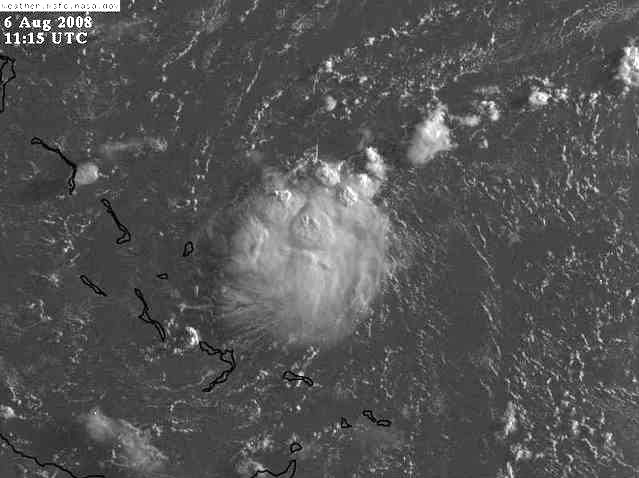
The thunderstorms that were over the everglades yesterday afternoon were more intense than this big westward moving cumulus cloud.(ex99L).
0 likes
-
Emmett_Brown

- Category 5

- Posts: 1433
- Joined: Wed Aug 24, 2005 9:10 pm
- Location: Sarasota FL
Re: Ex Invest 99L in Western Atlantic
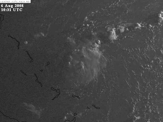
Take a look at this loop... the last few frames look like a developing TC to me, so I agree with Honeyko that this this is developing:
http://mkwc.ifa.hawaii.edu/satellite/satanim.cgi?chnl=ir&domain=bah&res=4km&size=large&period=720&incr=30&rr=900&banner=mkwc&satplat=goeseast&overlay=off
http://mkwc.ifa.hawaii.edu/satellite/satanim.cgi?chnl=ir&domain=bah&res=4km&size=large&period=720&incr=30&rr=900&banner=mkwc&satplat=goeseast&overlay=off
0 likes


Re: Ex Invest 99L in Western Atlantic
This is the closest reporting station that I can find, Does someone have one closer that the system should pass near to?
http://weather.noaa.gov/weather/current/MYEG.html
http://weather.noaa.gov/weather/current/MYEG.html
0 likes

Re: Ex Invest 99L in Western Atlantic
Honeyko wrote:The smallest tropical entity I've ever seen was Monica. The entire storm, at cat-5 equivalent strength in the northwest Gulf of Carpentaria, was scarcely any bigger than 99L is right now. Monica was basically a single hollow-tube CB rotating incredibly fast. (Later the storm expanded in coverage and weakened in strength.)RL3AO wrote:If thats a TC, were talking Tracy like small...but without the cat 4 part.
Like I said. I'll take your Monica and raise you Tracy, the smallest TC ever recorded.
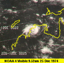
Thats a category 4 cyclone making landfall near Darwin.
0 likes
Re: Ex Invest 99L in Western Atlantic
Emmett_Brown wrote:Take a look at this loop... the last few frames look like a developing TC to me, so I agree with Honeyko that this this is developing:
http://mkwc.ifa.hawaii.edu/satellite/satanim.cgi?chnl=ir&domain=bah&res=4km&size=large&period=720&incr=30&rr=900&banner=mkwc&satplat=goeseast&overlay=off
Nice loop E B If this thing is down to the surface, IMHO it will be a problem!
I say this only as a long time Gawker.
0 likes
-
Honeyko
Re: Ex Invest 99L in Western Atlantic
Until Monica -- smaller and more powerful than Tracy. If you zoomed up your tiny pic of Tracy until the northern coastline matched the Monica pic, you'd see that Monica was barely two-thirds the size of Tracy.RL3AO wrote:Like I said. I'll take your Monica and raise you Tracy, the smallest TC ever recorded.
The defining characteristic of 99L for the last three days has been then it's been a completely surface phenomena.tailgator wrote:Nice loop E B If this thing is down to the surface, IMHO it will be a problem!
0 likes

-
Emmett_Brown
- Category 5
- Posts: 1433
- Joined: Wed Aug 24, 2005 9:10 pm
- Location: Sarasota FL
Re:
Chacor wrote:Tracy is the smallest known recorded cyclone. Please provide proof of your claim for Monica; this is getting close to trolling.
Probably best if we stay on topic... ex 99L if it develops will likely be small, regardless of how small the Aussy TC's were. Anyway, a look at the steering flow as predicted in 24 hours by the GFS shows that steering currents begin to slacken tomorrow ahead of the next east cost trough. This may mean a slow down near or over FL:

0 likes
-
Honeyko
Re:
>shrug< I call it like I see it. I've seen sat pics of both. Hell, there's pics of both right in this thread, and anybody can do what I suggested themselves. Monica was also only in 2006, and I'd merely suspect nobody's bothered to sit down and deal with a comparison in any "official" record-changing capacity that, say, Wikipedia would consider "notable".Chacor wrote:Tracy is the smallest known recorded cyclone. Please provide proof of your claim for Monica; this is getting close to trolling.
Small storms grow bigger until they reach a point at which they maximize their ability to process the atmosphere of the surrounding environment. (This is one reason why Katrina became a more powerful storm despite undergoing an eyewall-replacement-cycle resulting in a larger eye.)Emmett_Brown wrote:ex 99L if it develops will likely be small
Last edited by Honeyko on Wed Aug 06, 2008 6:29 am, edited 3 times in total.
0 likes
-
alan1961

- Category 2

- Posts: 771
- Joined: Mon Mar 20, 2006 11:58 am
- Location: Derby, Derbyshire, England
- Contact:
Re: Ex Invest 99L in Western Atlantic
IMO if this carries on convecting it could possibly do some stalling out over the lower Bahamas or slide down over cuba..any thoughts on this?
Last edited by alan1961 on Wed Aug 06, 2008 6:35 am, edited 1 time in total.
0 likes
Re: Ex Invest 99L in Western Atlantic
Another good loop
http://hadar.cira.colostate.edu/ramsdis ... at1_0.html
Looks like it on the northern edge of a ULL now.
http://www.ssd.noaa.gov/goes/east/watl/loop-wv.html
http://hadar.cira.colostate.edu/ramsdis ... at1_0.html
Looks like it on the northern edge of a ULL now.
http://www.ssd.noaa.gov/goes/east/watl/loop-wv.html
0 likes
-
Matt-hurricanewatcher
Re: Ex Invest 99L in Western Atlantic
This system reminds me a little of 10L of 2005. But this has fighted harder then it. I'm not saying it is "it" because that would in fact be trolling and lieing at the same time. But this does look very good...I knew this sucker was going to do this when all the models where showing recurve. The environment is not nearly that as it was for you know what. So maybe a weak tropical storm could be possible.
0 likes
Who is online
Users browsing this forum: No registered users and 48 guests