zaqxsw75050 wrote:
ATL: Tropical Depression Dolly
Moderator: S2k Moderators
-
zaqxsw75050

- Tropical Storm

- Posts: 178
- Joined: Thu Mar 06, 2008 4:21 pm
- Location: Hong Kong


Re: Re:
MiamiensisWx wrote:Weatherfreak000 wrote:Are you guys really thinking this through?
A lack of Convergence WILL NOT kill this Invest. It's in an otherwise favorable environment. That means it has DAYS to make something happen and unless the environment changes it's BOUND to happen.
Wxman's logic seems clear to me, nothing is in this storm's path to develop so it most likely will UNLESS another factor presents itself.
Have you analyzed the tropics for several years?
Maybe the poster hasn't, and was just posting their opinion.
0 likes
-
MiamiensisWx
Re: Re:
mutley wrote:Maybe the poster hasn't, and was just posting their opinion.
It was a question - I added the clarification in order to avoid unintentional harshness.
I merely disagree with his/her opinion. We'll see the final result.
Last edited by MiamiensisWx on Mon Jul 14, 2008 5:53 pm, edited 1 time in total.
0 likes
-
Extremeweatherguy

- Category 5

- Posts: 11095
- Joined: Mon Oct 10, 2005 8:13 pm
- Location: Florida
Re: ATL: INVEST 94L East of the Windward Islands
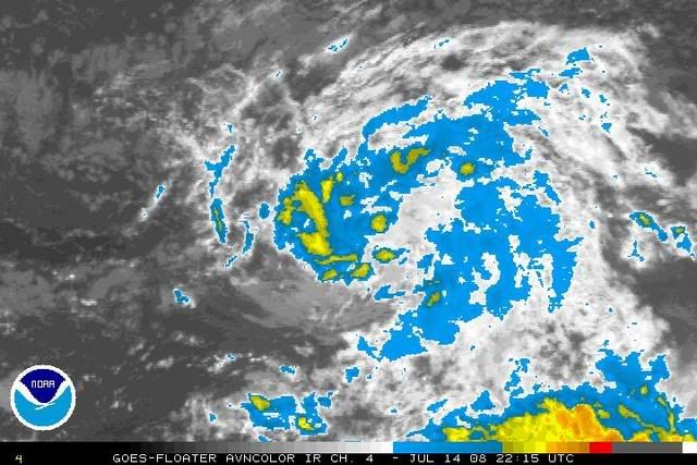
It looks like this system is starting to enter a more favorable area. An area of low-level convergence is developing on the NW side of 94L and the area of low-level divergence that was such a problem earlier now seems to be east of where the LLC is currently located.zaqxsw75050 wrote:
0 likes

Yep hopefully that trend continues if this system is going to develop extremeweatherguy, does look like divergence has weakened just a touch recently and this has been reflected in convection trying to pop closer to the center I think. With the Dmax this may help to boost the convection further, we will see.
0 likes
-
Weatherfreak000
Re: Re:
MiamiensisWx wrote:Weatherfreak000 wrote:Are you guys really thinking this through?
A lack of Convergence WILL NOT kill this Invest. It's in an otherwise favorable environment. That means it has DAYS to make something happen and unless the environment changes it's BOUND to happen.
Wxman's logic seems clear to me, nothing is in this storm's path to develop so it most likely will UNLESS another factor presents itself.
Have you analyzed the tropics for several years? This is just a question...
I have seen several historical July systems that never featured a long lived LLC because of scanty low level convergence during their early life spans.
I doubt development will occur beyond a TD classification.
I have, but let me ask you something are you implying these conditions for the next 24 Hours? (Note please: NOT saying this storm will definitely develop)
In some of the cases your mentioning if memory serves me right, the lack of convective activity caused the Low Level Center to spin down, and somewhat quickly causing the storm to fall apart. This invest has been generally devoid of convective activity for i'd argue about 12 hours and yet the LLC is IMPROVING structure regardless.
I'd have to argue against this being a factor due to 2 reasons:
1. The collapse in Convergence is due to the ITCZ. The storm will push away from the ITCZ and therefore improving conditions are coming regardless of whether the storm is going to develop or not..
2. Wind Shear and Dry Air are nonexistent in it's path...
This is a classic case of the ITCZ robbing the invest of convection and they very typically refire. Again my friend...THAT is something I thought an individual who watches the tropics would know...
0 likes
-
txwatcher91
- Category 5
- Posts: 1498
- Joined: Tue Aug 02, 2005 2:29 pm
-
MiamiensisWx
Re: Re:
Weatherfreak000 wrote:I have, but let me ask you something are you implying these conditions for the next 24 Hours? (Note please: NOT saying this storm will definitely develop)
In some of the cases your mentioning if memory serves me right, the lack of convective activity caused the Low Level Center to spin down, and somewhat quickly causing the storm to fall apart. This invest has been generally devoid of convective activity for i'd argue about 12 hours and yet the LLC is IMPROVING structure regardless.
I'd have to argue against this being a factor due to 2 reasons:
1. The collapse in Convergence is due to the ITCZ. The storm will push away from the ITCZ and therefore improving conditions are coming regardless of whether the storm is going to develop or not..
2. Wind Shear and Dry Air are nonexistent in it's path...
This is a classic case of the ITCZ robbing the invest of convection and they very typically refire. Again my friend...THAT is something I thought an individual who watches the tropics would know...
I agree with the bolded portion, and I mentioned it in another post, though it did not utilize "Intertropical Convergence Zone" in my synopsis. However, I've always been very aware of the bolded fact.
Personally, I've been perusing visible data, and the formative broad LLC still appears identical in organization to previous hours.
Subsidence can be present at the low levels, while WV imagery indicates the mid/upper levels. WV data still shows some mid level dry air to the NW.
We'll agree to disagree in terms of this system's future.
0 likes
-
Gustywind

- Category 5
- Posts: 12334
- Joined: Mon Sep 03, 2007 7:29 am
- Location: Baie-Mahault, GUADELOUPE
Re: Re:
jlauderdal wrote:Gustywind wrote:http://www.meteo.fr/temps/domtom/antilles/pack-public/TAG/Tagant.jpg
http://www.meteo.fr/temps/domtom/antill ... Tagguy.jpg
System is always there and racing west near the Lesser Antilles and should be a threat Saturday or Sunday for Guadeloupe given the last weather forecast at 5 PM of our ProMet from Meteo-France. So i have heard in many replies "it's dead or it's dead Jim "dead or not, we have something getting more organized this afternoon and very suspicious, very low in lattitude and with a decent structure. It's another reason for all carib islanders to monitor carefully this area...

we had to get the meteo-france post in there because its bastille day.
Absolutely my friend glad to see that you knew that i appreciate
Whereas, do you want something else in terms of info of Meteo france forecast..???
As i said it i in my last reply; i was a little amazed...because they have anticipated the fact that this could be fairly a little thread for us in Guadeloupe
0 likes


-
PTrackerLA

- Category 5
- Posts: 5281
- Age: 42
- Joined: Thu Oct 10, 2002 8:40 pm
- Location: Lafayette, LA
Re: ATL: INVEST 94L East of the Windward Islands
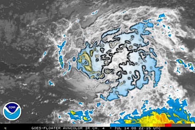
Looks like we have some scattered convection popping up. I agree with wxman's thinking that we'll see this continue overnight.
http://www.ssd.noaa.gov/goes/flt/t2/loop-ir2.html
http://www.ssd.noaa.gov/goes/flt/t2/loop-ir2.html
0 likes
-
tolakram
- Admin

- Posts: 20179
- Age: 62
- Joined: Sun Aug 27, 2006 8:23 pm
- Location: Florence, KY (name is Mark)
Re: ATL: INVEST 94L East of the Windward Islands

I'll believe it when it lasts more than 6 hours.
I'm really wishing this thing would do a like a lot of July invests and fizzle out.
0 likes


-
Extremeweatherguy
- Category 5
- Posts: 11095
- Joined: Mon Oct 10, 2005 8:13 pm
- Location: Florida
Based on the latest IR loop, 94L doesn't look half bad right now. It has quite a good looking structure and with the new convection popping near the center, I think this system is well on its way to becoming TD#3 by tomorrow (assuming this convection holds or grows overnight).
The posts in this forum are NOT official forecast and should not be used as such. They are just the opinion of the poster and may or may not be backed by sound meteorological data. They are NOT endorsed by any professional institution or storm2k.org. For official information, please refer to the NHC and NWS products.
The posts in this forum are NOT official forecast and should not be used as such. They are just the opinion of the poster and may or may not be backed by sound meteorological data. They are NOT endorsed by any professional institution or storm2k.org. For official information, please refer to the NHC and NWS products.
0 likes
-
HURRICANELONNY
- Category 5
- Posts: 1390
- Joined: Wed May 07, 2003 6:48 am
- Location: HOLLYWOOD.FL
Re: ATL: INVEST 94L East of the Windward Islands
From the looks of 94L on IR loop. It's fighting dry air and low latitude. Like most say on there posts. Once it heads more wnw it should increase in convection and be a depression by tomorrow sometime. 94L has a well defined low. Don't know if it is a LLC or MLC. But well defined. I would say it would be hard pressed for 94L to go puff. Unless it encounters alot of shear. Which I don't see ahead of it. 
0 likes
Possibly HURRICANELONNY I still think that there is still slight divergence which is holding the convection back a little bit in terms of depth but it does at least for now appear to have eased off.
If I had to guess if it does form then the main strengthening would occur 55W onwards but who knows really, still a massive IF IMO.
If I had to guess if it does form then the main strengthening would occur 55W onwards but who knows really, still a massive IF IMO.
0 likes
Who is online
Users browsing this forum: No registered users and 22 guests