ATL: Tropical Depression Fay
Moderator: S2k Moderators

Saying that wxman57 there does appear to be at least some sort of turning at the mid levels by looking at the loops in the last few hours, I agree no circulation at the surface but if convection can hold then eventually it'll work its way down...of course the problem has been getting it to hold.
0 likes

Re: ATL: Invest 92L - Central Atlantic
Actually I have just south and east, almost where wxman has his crosshairs. Will sure be glad when there is a visible. I really wish http://ndbc.noaa.gov/station_page.php?station=41nt0 would update, it is at 14.5 N 50.5 W, and would give a clearer picture.west of the deepest of that convection but that big burst
0 likes
Re: ATL: Invest 92L - Central Atlantic
Can anyone tell me where to find a current map of Oceanic Heat Content, or Tropical Cyclone Potential for the area between 92L and Florida?
0 likes


Re: ATL: Invest 92L - Central Atlantic
physicx07 wrote:Can anyone tell me where to find a current map of Oceanic Heat Content, or Tropical Cyclone Potential for the area between 92L and Florida?
TCHP
http://www.aoml.noaa.gov/phod/dataphod1/work/HHP/NEW/2008223at.jpg
0 likes
Re: ATL: Invest 92L - Central Atlantic
Thanks. If it's going where I think it is, it might have a problem getting very strong. It would even probably sputter pretty bad just north of Hispaniola.
RL3AO wrote:physicx07 wrote:Can anyone tell me where to find a current map of Oceanic Heat Content, or Tropical Cyclone Potential for the area between 92L and Florida?
TCHP
http://www.aoml.noaa.gov/phod/dataphod1/work/HHP/NEW/2008223at.jpg
0 likes


Re: ATL: Invest 92L - Central Atlantic
Are the RAMSDIS sat loops skipping for anyone else or is it something on my end?
0 likes
-
HURAKAN

- Professional-Met

- Posts: 46084
- Age: 39
- Joined: Thu May 20, 2004 4:34 pm
- Location: Key West, FL
- Contact:
Re: ATL: Invest 92L - Central Atlantic
Jam151 wrote:Are the RAMSDIS sat loops skipping for anyone else or is it something on my end?
I have the same problem. They don't seem to update.
0 likes
-
carolina_73

- Tropical Storm

- Posts: 148
- Joined: Wed Jul 23, 2008 1:30 am
Re: ATL: Invest 92L - Central Atlantic
Think there is a good chance Recon will investigate later today?
0 likes


-
HURAKAN
- Professional-Met
- Posts: 46084
- Age: 39
- Joined: Thu May 20, 2004 4:34 pm
- Location: Key West, FL
- Contact:
Re: ATL: Invest 92L - Central Atlantic
carolina_73 wrote:Think there is a good chance Recon will investigate later today?
It needs to reach 55W before 18Z, if so, and it continues to look intriguing, I think they would go just like 94L.
0 likes
Re: ATL: Invest 92L - Central Atlantic
wxman57, is there a chance an LLC could be so small that it wouldn't be recognizable based on wind observations from buoys at such distances? Just curious.
0 likes
-
Ed Mahmoud
Re: ATL: Invest 92L - Central Atlantic
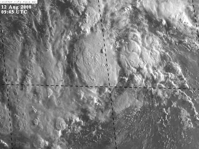
Looking at the RAMSDIS loop from previous page, I see a broad elliptical circulation, with two areas at opposite ends of the ellipse with maximum turning. Maximum turning near 50ºW, or a shade East of the biggest convective blob.
0 likes
-
Extremeweatherguy

- Category 5

- Posts: 11095
- Joined: Mon Oct 10, 2005 8:13 pm
- Location: Florida
Re: ATL: Invest 92L - Central Atlantic
Yeah, the southern inflow is very evident on that loop.xironman wrote:You are not alone, the RAMSDIS loop http://rammb.cira.colostate.edu/ramsdis/online/loop_640.asp?product=tropical_ge_4km_visir2_floater_1 even shows it better. The southern inflow looks much better and clearly curving around the area.
0 likes

Re: ATL: Invest 92L - Central Atlantic
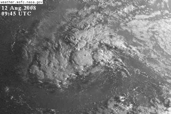
If the low level organization is weak its likely any LLC will relocate or form further north under the convection again.
Looks like 92L is still feeling the effects of that ULL to the north that MW mentioned yesterday.
The ULL looks like it is beginning to slide NE and the dry air is not as close to the emerging center as it was. Could have a tenacious TD today, or it could go through another poof cycle and migrate a little further north.
I think once the models have an intensifying TD to initialize with they will show a much stronger system later in the forecast. We need to focus on the upper air forecast for now and as Derek always states, don't project some monster storm out of our dark psyche just because the track is towards the conus.
0 likes
Who is online
Users browsing this forum: No registered users and 10 guests