ATL: Tropical Depression Fay

Moderator: S2k Moderators

Message
Author
User avatar
HURAKAN
Professional-Met
Professional-Met
Posts: 46086
Age: 37
Joined: Thu May 20, 2004 4:34 pm
Location: Key West, FL
Contact:

#81 Postby HURAKAN » Sun Aug 10, 2008 9:22 am

Image

Long week ahead.
0 likes   

User avatar
Recurve
Category 5
Category 5
Posts: 1630
Joined: Tue Aug 16, 2005 8:59 pm
Location: St. Petersburg, FL

Re: ATL: Invest 92L - Central Atlantic

#82 Postby Recurve » Sun Aug 10, 2008 9:25 am

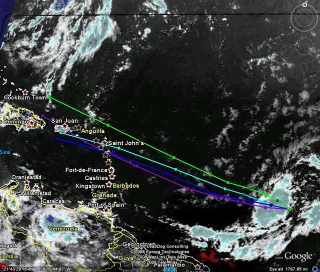
If you haven't seen it, check out the Google Earth link posted at NRL. Click the little KML button next to 92L on the home page. Very cool.

Image
Last edited by Recurve on Sun Aug 10, 2008 9:27 am, edited 1 time in total.
0 likes   

User avatar
Gustywind
Category 5
Category 5
Posts: 12334
Joined: Mon Sep 03, 2007 7:29 am
Location: Baie-Mahault, GUADELOUPE

#83 Postby Gustywind » Sun Aug 10, 2008 9:26 am

http://www.meteo.fr/temps/domtom/antill ... Tagant.jpg
Good bulk of convection persisting with lots of moisture in vicinity...
0 likes   

MCWX
Tropical Low
Tropical Low
Posts: 16
Joined: Wed Sep 19, 2007 8:58 am

#84 Postby MCWX » Sun Aug 10, 2008 9:26 am

The GFS may be overdoing the depth of the full latitude trough. I would not be so sure of recurvature or a East coast destination of the several potential features to come (if they come). I would note the ECMWF ensembles depict the Atlantic ridge building back to the west quickly and the aforementioned trough fracturing. It has been doing this for days now in contrast to the American based enembles.

It would not be prudent to discount an ultimate threat farther west so early in the game irrespective of what the extended steering currents show on the American operational run.

Should be interesting watching trends on the models for the West North American coast as that will help determine the downstream response and that response could have an impact of anything that forms...if anything forms.
0 likes   

User avatar
Gustywind
Category 5
Category 5
Posts: 12334
Joined: Mon Sep 03, 2007 7:29 am
Location: Baie-Mahault, GUADELOUPE

Re:

#85 Postby Gustywind » Sun Aug 10, 2008 9:27 am

HURAKAN wrote:Image

Long week ahead.

Nice hurakan tkanks that's beautiful but not the tracks :( :spam:
0 likes   

Mecklenburg

Re: ATL: Invest 92L - Central Atlantic

#86 Postby Mecklenburg » Sun Aug 10, 2008 9:33 am

bvigal wrote:Hurakan, glad you posted that dvorak. I've been running the loop, and I think we'll have a depression in another hour.
http://www.ssd.noaa.gov/goes/flt/t1/loop-bd.html

so soon?
0 likes   

User avatar
cycloneye
Admin
Admin
Posts: 139596
Age: 67
Joined: Thu Oct 10, 2002 10:54 am
Location: San Juan, Puerto Rico

Re: ATL: Invest 92L - Central Atlantic

#87 Postby cycloneye » Sun Aug 10, 2008 9:34 am

Historiclly,when storms and hurricanes haved moved over or very close to Guadeloupe,Puerto Rico gets a landfall or a near miss,is like the Hebert box at 20n-60w for Florida,Guadeloupe is our box.
0 likes   

User avatar
Blown Away
S2K Supporter
S2K Supporter
Posts: 9874
Joined: Wed May 26, 2004 6:17 am

Re: ATL: Invest 92L - Central Atlantic

#88 Postby Blown Away » Sun Aug 10, 2008 9:36 am

Nice summary from Jeff Master's this morning, he thinks possible (2) impacts to the Antille's over the next week or so.
http://www.wunderground.com/blog/JeffMa ... amp=200808
0 likes   

User avatar
Ola
Category 1
Category 1
Posts: 299
Joined: Mon Apr 21, 2003 11:24 pm
Location: Dorado, Puerto Rico

Re: ATL: Invest 92L - Central Atlantic

#89 Postby Ola » Sun Aug 10, 2008 9:37 am

Recurve wrote:If you haven't seen it, check out the Google Earth link posted at NRL. Click the little KML button next to 92L on the home page. Very cool.

Image


How you do that? Can you explain a bit more? Im at NRL but cant find a google earth link threre.
0 likes   

User avatar
HURAKAN
Professional-Met
Professional-Met
Posts: 46086
Age: 37
Joined: Thu May 20, 2004 4:34 pm
Location: Key West, FL
Contact:

#90 Postby HURAKAN » Sun Aug 10, 2008 9:37 am

Image
0 likes   

User avatar
Recurve
Category 5
Category 5
Posts: 1630
Joined: Tue Aug 16, 2005 8:59 pm
Location: St. Petersburg, FL

Re: ATL: Invest 92L - Central Atlantic

#91 Postby Recurve » Sun Aug 10, 2008 9:41 am

Ola wrote:
How you do that? Can you explain a bit more? Im at NRL but cant find a google earth link threre.


There's a tiny little red button next to the label at the top of the NRL page. See this screen shot:


Image
0 likes   

User avatar
wxman57
Moderator-Pro Met
Moderator-Pro Met
Posts: 22506
Age: 66
Joined: Sat Jun 21, 2003 8:06 pm
Location: Houston, TX (southwest)

Re: ATL: Invest 92L - Central Atlantic

#92 Postby wxman57 » Sun Aug 10, 2008 9:46 am

deltadog03 wrote:WXMAN, whats going on buddy?? Hey, thanks for that map from the GFS...Looks like EURO is also in fairly good agreement with the synoptic setup and the GFS. Question, if you have the time, is there anyway, we can find out what the steering levels looked like when Francis and Jeanne came into FL?? Can we find that out from the plymouth state site?


I found this 500mb flow chart I made for Frances (I save a lot of stuff from each storm for my presentations):

http://myweb.cableone.net/nolasue/frances38.gif

Didn't have anything I'd saved for Jeanne.
0 likes   

User avatar
Gustywind
Category 5
Category 5
Posts: 12334
Joined: Mon Sep 03, 2007 7:29 am
Location: Baie-Mahault, GUADELOUPE

Re: ATL: Invest 92L - Central Atlantic

#93 Postby Gustywind » Sun Aug 10, 2008 9:48 am

cycloneye wrote:Historiclly,when storms and hurricanes haved moved over or very close to Guadeloupe,Puerto Rico gets a landfall or a near miss,is like the Hebert box at 20n-60w for Florida,Guadeloupe is our box.

Good point Cycloneye you're right :). If we're directly concerned there's higher chances that you should too unhopefully :oops: ...
0 likes   

User avatar
Blown Away
S2K Supporter
S2K Supporter
Posts: 9874
Joined: Wed May 26, 2004 6:17 am

Re: ATL: Invest 92L - Central Atlantic

#94 Postby Blown Away » Sun Aug 10, 2008 9:49 am

wxman57 wrote:
deltadog03 wrote:WXMAN, whats going on buddy?? Hey, thanks for that map from the GFS...Looks like EURO is also in fairly good agreement with the synoptic setup and the GFS. Question, if you have the time, is there anyway, we can find out what the steering levels looked like when Francis and Jeanne came into FL?? Can we find that out from the plymouth state site?


I found this 500mb flow chart I made for Frances (I save a lot of stuff from each storm for my presentations):

http://myweb.cableone.net/nolasue/frances38.gif

Didn't have anything I'd saved for Jeanne.


Wow, forgot how pretty Frances was out at sea, she wasn't pretty when she was pounding my town. So Wxman57, is the setup appear to be similiar?
0 likes   

User avatar
Ola
Category 1
Category 1
Posts: 299
Joined: Mon Apr 21, 2003 11:24 pm
Location: Dorado, Puerto Rico

Re: ATL: Invest 92L - Central Atlantic

#95 Postby Ola » Sun Aug 10, 2008 9:50 am

Recurve wrote:
Ola wrote:
How you do that? Can you explain a bit more? Im at NRL but cant find a google earth link threre.


There's a tiny little red button next to the label at the top of the NRL page. See this screen shot:


Image


Cool thanks, but............. all I get is the 92l icon on google earth. Do you have more links for like sat overlays and stuff?
0 likes   

User avatar
HURAKAN
Professional-Met
Professional-Met
Posts: 46086
Age: 37
Joined: Thu May 20, 2004 4:34 pm
Location: Key West, FL
Contact:

#96 Postby HURAKAN » Sun Aug 10, 2008 9:50 am

Image

Follow the leader 92L.
0 likes   

User avatar
cycloneye
Admin
Admin
Posts: 139596
Age: 67
Joined: Thu Oct 10, 2002 10:54 am
Location: San Juan, Puerto Rico

Re:

#97 Postby cycloneye » Sun Aug 10, 2008 9:51 am

HURAKAN wrote:Image

Follow the leader 92L.


The train has left the station.
0 likes   

User avatar
bvigal
S2K Supporter
S2K Supporter
Posts: 2275
Joined: Sun Jul 24, 2005 8:49 am
Location: British Virgin Islands
Contact:

Re: ATL: Invest 92L - Central Atlantic

#98 Postby bvigal » Sun Aug 10, 2008 9:53 am

Ola wrote:
Recurve wrote:
Ola wrote:How you do that? Can you explain a bit more? Im at NRL but cant find a google earth link threre.
There's a tiny little red button next to the label at the top of the NRL page. See this screen shot:
Image
Cool thanks, but............. all I get is the 92l icon on google earth. Do you have more links for like sat overlays and stuff?
I'd be happy if NRL would re-position their sats from that old 41.3 fix. The west portion of 92L is already out of the closeup vis!
0 likes   

User avatar
Recurve
Category 5
Category 5
Posts: 1630
Joined: Tue Aug 16, 2005 8:59 pm
Location: St. Petersburg, FL

Re: ATL: Invest 92L - Central Atlantic

#99 Postby Recurve » Sun Aug 10, 2008 9:55 am

Ola wrote:
Recurve wrote:
Ola wrote:
How you do that? Can you explain a bit more? Im at NRL but cant find a google earth link threre.


There's a tiny little red button next to the label at the top of the NRL page. See this screen shot:


Image


Cool thanks, but............. all I get is the 92l icon on google earth. Do you have more links for like sat overlays and stuff?


Ola -- Click on the marker itself out in the ocean. That displays a large box with satellite links. Also, look in the "my places" bar on the left for all the layers that have been added. Feel free to PM me if you need more info. - Dave
0 likes   

User avatar
Gustywind
Category 5
Category 5
Posts: 12334
Joined: Mon Sep 03, 2007 7:29 am
Location: Baie-Mahault, GUADELOUPE

Re: Re:

#100 Postby Gustywind » Sun Aug 10, 2008 9:57 am

cycloneye wrote:
HURAKAN wrote:Image

Follow the leader 92L.


The train has left the station.

With much energy but i don't like the slam or "the dunk you very much " as the ESPN basket ball commentators would say in any east carib islands or lands....
0 likes   


Return to “2008”

Who is online

Users browsing this forum: No registered users and 9 guests