ATL: Tropical Depression Dolly

Moderator: S2k Moderators

Message
Author
paintplaye
Category 1
Category 1
Posts: 380
Joined: Sun Jul 20, 2008 11:25 pm

Re: ATL: H Dolly in Western Gulf of Mexico

#7181 Postby paintplaye » Wed Jul 23, 2008 3:58 am

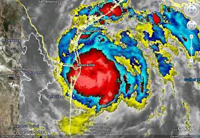
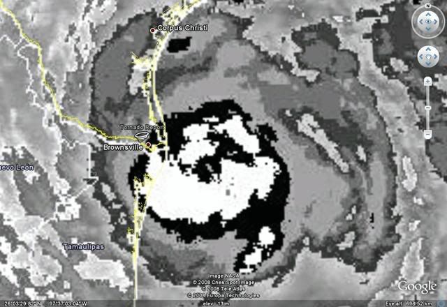
americanrebel wrote:Yeah, so at best this will be a Cat. 2 hurricane at landfall, that is if it continues on it continue slow jog to the NW then to its WNW movement. But if for any reason the trough to the north continues to dig to the South and the High to her N continues to shift East and the High to her SW continues to nudge North, she could very easily turn due N. All the mets are hoping this don't happen, but with Mother Nature you never know what she has planned.

Everything that was just stated is my own opinion and is not backed by any one or any governmental agencies.


That is if all that happens. Then we could see that unusual last minute north turn like that one model did.
0 likes   

User avatar
HURAKAN
Professional-Met
Professional-Met
Posts: 46086
Age: 38
Joined: Thu May 20, 2004 4:34 pm
Location: Key West, FL
Contact:

#7182 Postby HURAKAN » Wed Jul 23, 2008 4:07 am

Image
0 likes   

User avatar
HURAKAN
Professional-Met
Professional-Met
Posts: 46086
Age: 38
Joined: Thu May 20, 2004 4:34 pm
Location: Key West, FL
Contact:

#7183 Postby HURAKAN » Wed Jul 23, 2008 4:11 am

Image

"A rope tornado was reported by spotters near highway 100 and 77."
0 likes   

paintplaye
Category 1
Category 1
Posts: 380
Joined: Sun Jul 20, 2008 11:25 pm

#7184 Postby paintplaye » Wed Jul 23, 2008 4:12 am

Man the weather channel is talking about storms in New York. This hurricane is defiantly not getting a lot of media attention.
0 likes   

User avatar
KWT
Category 5
Category 5
Posts: 31415
Joined: Tue Aug 17, 2004 11:02 am
Location: UK!!!

#7185 Postby KWT » Wed Jul 23, 2008 4:14 am

Dolly looks like its strengthening right upto landfall, probably stil lgot another 3-4hrs over water so may yet get another little bit of strengthening, esp given the pressure has recently really dropped quite a lot and so I would have thought winds will be risising right upto landfall which is not a good thing for Bro. TS strength winds will soon be reaching there once the the inner core reaches land.
0 likes   

User avatar
HarlequinBoy
Category 5
Category 5
Posts: 1400
Age: 34
Joined: Wed Nov 29, 2006 1:57 am
Location: Memphis

#7186 Postby HarlequinBoy » Wed Jul 23, 2008 4:17 am

The reported rope tornado was 3 NW of Rancho Viejo in Cameron County.
0 likes   

americanrebel

Re:

#7187 Postby americanrebel » Wed Jul 23, 2008 4:19 am

KWT wrote:Dolly looks like its strengthening right upto landfall, probably stil lgot another 3-4hrs over water so may yet get another little bit of strengthening, esp given the pressure has recently really dropped quite a lot and so I would have thought winds will be risising right upto landfall which is not a good thing for Bro. TS strength winds will soon be reaching there once the the inner core reaches land.


Where do you get that she will only be over water for 3-4 more hours? I see it being out there for at least another 10 hours if not longer.
0 likes   

User avatar
HURAKAN
Professional-Met
Professional-Met
Posts: 46086
Age: 38
Joined: Thu May 20, 2004 4:34 pm
Location: Key West, FL
Contact:

#7188 Postby HURAKAN » Wed Jul 23, 2008 4:20 am

The next RECON is likely the most interesting yet.
0 likes   

User avatar
Normandy
Category 5
Category 5
Posts: 2293
Joined: Sun Oct 10, 2004 12:31 am
Location: Houston, TX

Re: ATL: H Dolly in Western Gulf of Mexico

#7189 Postby Normandy » Wed Jul 23, 2008 4:22 am

^You know whats interesting, you might be right. One only needs to look at radar trends to show that Dolly is moving pretty NW, if not NNW it seems. Brownsville is almost at the same latitude at the eye itself right now, and soon we may need to consider the possibility of Brownsville being on the weaker side of this system (Southern eyewall). That is EXCELLENT news as the stronger portion of this storm might pass over less populated areas (Although Port Mansfield might get raked). But anyways to your point, yes if it continues this trend it could spend a few more hours over water....and at the rate this is deepening thats dangerous.
0 likes   

User avatar
KWT
Category 5
Category 5
Posts: 31415
Joined: Tue Aug 17, 2004 11:02 am
Location: UK!!!

#7190 Postby KWT » Wed Jul 23, 2008 4:22 am

Well I may well be wrong americanrebel it probably will be over water for longer, which isn't a great tyhing given its still bursting close to land.
0 likes   

paintplaye
Category 1
Category 1
Posts: 380
Joined: Sun Jul 20, 2008 11:25 pm

Re: Re:

#7191 Postby paintplaye » Wed Jul 23, 2008 4:23 am

americanrebel wrote:
KWT wrote:Dolly looks like its strengthening right upto landfall, probably stil lgot another 3-4hrs over water so may yet get another little bit of strengthening, esp given the pressure has recently really dropped quite a lot and so I would have thought winds will be risising right upto landfall which is not a good thing for Bro. TS strength winds will soon be reaching there once the the inner core reaches land.


Where do you get that she will only be over water for 3-4 more hours? I see it being out there for at least another 10 hours if not longer.


No with it moving at even 7 or 8mph it would be inland in about 5 hours or so. But....... it does looked stalled right now. So we will have to see.
0 likes   

americanrebel

Re: Re:

#7192 Postby americanrebel » Wed Jul 23, 2008 4:25 am

paintplaye wrote:
americanrebel wrote:
KWT wrote:Dolly looks like its strengthening right upto landfall, probably stil lgot another 3-4hrs over water so may yet get another little bit of strengthening, esp given the pressure has recently really dropped quite a lot and so I would have thought winds will be risising right upto landfall which is not a good thing for Bro. TS strength winds will soon be reaching there once the the inner core reaches land.


Where do you get that she will only be over water for 3-4 more hours? I see it being out there for at least another 10 hours if not longer.


No with it moving at even 7 or 8mph it would be inland in about 5 hours or so. But....... it does looked stalled right now. So we will have to see.


She is at least 60 miles from the Coast and 8 miles an hour would put it at best 7.5 hours.
0 likes   

User avatar
KWT
Category 5
Category 5
Posts: 31415
Joined: Tue Aug 17, 2004 11:02 am
Location: UK!!!

#7193 Postby KWT » Wed Jul 23, 2008 4:25 am

paintplaye, yeah thats what made me say 3-4hrs,that maybe a little too quickly esp if it does slow down just before landfall like its progged but we will see.
0 likes   

User avatar
Normandy
Category 5
Category 5
Posts: 2293
Joined: Sun Oct 10, 2004 12:31 am
Location: Houston, TX

Re: ATL: H Dolly in Western Gulf of Mexico

#7194 Postby Normandy » Wed Jul 23, 2008 4:26 am

Indeed, and that is assuming she books it straight west from this point. Good news right now is that it seems Brownsville might be spared the right front quadrant of this storm (Even though the southern eyewall will likely still rake them very good).
0 likes   

paintplaye
Category 1
Category 1
Posts: 380
Joined: Sun Jul 20, 2008 11:25 pm

Re: Re:

#7195 Postby paintplaye » Wed Jul 23, 2008 4:26 am

americanrebel wrote:
KWT wrote:Dolly looks like its strengthening right upto landfall, probably stil lgot another 3-4hrs over water so may yet get another little bit of strengthening, esp given the pressure has recently really dropped quite a lot and so I would have thought winds will be risising right upto landfall which is not a good thing for Bro. TS strength winds will soon be reaching there once the the inner core reaches land.


Where do you get that she will only be over water for 3-4 more hours? I see it being out there for at least another 10 hours if not longer.


No with it moving at even 7 or 8mph it would be inland in about 5 hours or so. But....... it does looked stalled right now. So we will have to see.


She is at least 60 miles from the Coast and 8 miles an hour would put it at best 7.5 hours.[/quote]

Hmm i thought she was closer. Ya idk i could be wrong. If this thing takes a turn north (which it could considering this thing is stalled) then we could have a major hurricane on our hands.
0 likes   

User avatar
HURAKAN
Professional-Met
Professional-Met
Posts: 46086
Age: 38
Joined: Thu May 20, 2004 4:34 pm
Location: Key West, FL
Contact:

#7196 Postby HURAKAN » Wed Jul 23, 2008 4:27 am

HURRICANE DOLLY ADVISORY NUMBER 12...CORRECTED
NWS TPC/NATIONAL HURRICANE CENTER MIAMI FL AL042008
400 AM CDT WED JUL 23 2008

DOLLY IS MOVING TOWARD THE NORTHWEST NEAR 8 MPH...13 KM/HR...AND
NORTHWESTWARD TO WEST-NORTHWESTWARD MOTION WITH A SLIGHT DECREASE
IN FORWARD SPEED IS EXPECTED TODAY. ON THE FORECAST TRACK...THE
CENTER OF DOLLY WILL BE ALONG THE COAST NEAR THE TEXAS/MEXICO
BORDER AROUND MIDDAY TODAY.


HURRICANE DOLLY DISCUSSION NUMBER 12
NWS TPC/NATIONAL HURRICANE CENTER MIAMI FL AL042008
500 AM EDT WED JUL 23 2008

SHOULD DOLLY MOVE MORE SLOWLY OVER EXTREME SOUTHERN TEXAS THAN WE
ARE FORECASTING...IT IS POSSIBLE FOR IT TO PRODUCE EVEN MORE
RAINFALL THAN WE ARE CURRENTLY PREDICTING.
0 likes   

User avatar
KWT
Category 5
Category 5
Posts: 31415
Joined: Tue Aug 17, 2004 11:02 am
Location: UK!!!

#7197 Postby KWT » Wed Jul 23, 2008 4:28 am

Yep and thats the really good thing Normandy, of course if it does really get going even the southern side could be fairly decent in strength with the stronger winds mixing down to the surface.

Hurakan, yeah so a little while yet then, enough time to get upto cat-2 quite possibly.
0 likes   

americanrebel

Re: ATL: H Dolly in Western Gulf of Mexico

#7198 Postby americanrebel » Wed Jul 23, 2008 4:29 am

No problem, just didn't want he big posters get on here and jump all over you. I'm not angry or anything, just wanted to make sure you were aware of the distance.

I am pretty sure Louisiana is safe now, but Corpus Christi might not be.
0 likes   

paintplaye
Category 1
Category 1
Posts: 380
Joined: Sun Jul 20, 2008 11:25 pm

Re:

#7199 Postby paintplaye » Wed Jul 23, 2008 4:30 am

HURAKAN wrote:HURRICANE DOLLY ADVISORY NUMBER 12...CORRECTED
NWS TPC/NATIONAL HURRICANE CENTER MIAMI FL AL042008
400 AM CDT WED JUL 23 2008

DOLLY IS MOVING TOWARD THE NORTHWEST NEAR 8 MPH...13 KM/HR...AND
NORTHWESTWARD TO WEST-NORTHWESTWARD MOTION WITH A SLIGHT DECREASE
IN FORWARD SPEED IS EXPECTED TODAY. ON THE FORECAST TRACK...THE
CENTER OF DOLLY WILL BE ALONG THE COAST NEAR THE TEXAS/MEXICO
BORDER AROUND MIDDAY TODAY.


HURRICANE DOLLY DISCUSSION NUMBER 12
NWS TPC/NATIONAL HURRICANE CENTER MIAMI FL AL042008
500 AM EDT WED JUL 23 2008

SHOULD DOLLY MOVE MORE SLOWLY OVER EXTREME SOUTHERN TEXAS THAN WE
ARE FORECASTING...IT IS POSSIBLE FOR IT TO PRODUCE EVEN MORE
RAINFALL THAN WE ARE CURRENTLY PREDICTING.


Idk how this could happen with it almost due west of Brownsville..... Maybe they see something i don't
0 likes   

User avatar
HURAKAN
Professional-Met
Professional-Met
Posts: 46086
Age: 38
Joined: Thu May 20, 2004 4:34 pm
Location: Key West, FL
Contact:

#7200 Postby HURAKAN » Wed Jul 23, 2008 4:30 am

Image
0 likes   


Return to “2008”

Who is online

Users browsing this forum: Google [Bot] and 2 guests