TC Bertha
Moderator: S2k Moderators

-
MiamiensisWx
Re: INVEST 92L in the Eastern Atlantic
Hyperstorm wrote:I've been on this board for years and the people that have seen me around know that I usually post when I see something interesting going on. Why get sensitive when someone disagrees with you, especially if they've explained their position with current satellite analysis/forecast models and not climatology?
Yesterday's satellite images were not lying. This system is a VERY strong system for any time of the year. Sometimes you cannot look at what the previous waves do in an area or the time of the year. You have to look at CURRENT conditions and current satellite images. The images showed a well-defined low pressure system with explosive convection as it moved off the coast...very ominous signs of Cape Verde developers as I mentioned yesterday. Where is the wave now? Over the water and not inland. How strong is it? Not your typical June/July wave...
Latest satellite images show an explosion of deep thunderstorms right over the main "center" over the water! SSTs are warm where the system is at and a depression may be closer than some think...
This post and the one by NDG in regards to my "Nigeria" prognosis has briefly forced me to make one final clarification.
At the time, most of the model guidance indicated they were developing the wave behind the impressive one that has currently exited the African coastline. I may or may not trust those models, but I presumed the consistency in regards to the second wave axis was genuine, since I originally believed the current weak surface low off Africa would merge with a broader area of low pressure associated with the second wave. The wave axis of this secondary wave was located in the vicinity of Nigeria last night. In other words, I made an error in my judgment, especially since the timing of some models were too slow with the first (current) wave axis' "entrance" into the eastern tropical Atlantic.
Finally, in regards to the bolded portion, anyone who is familiar with me knows that I readily accept criticism; in fact, it is necessary for all people in meteorology. Constructive critique and disagreements are always welcome. However, if the criticism makes a false statement (slander) about my forecast(s)/analyses, it is another issue. I never utilized climatology as my argument against the development of this system. My original post did not even mention the word "climatology".
Regardless of semantics, I still doubt this one will develop, as it will eventually encounter stronger upper level shear from a trough to the west.
I'll head back to the woodwork.
Adios (again),
Miami
Last edited by MiamiensisWx on Tue Jul 01, 2008 9:21 am, edited 1 time in total.
0 likes
-
gatorcane

- S2K Supporter

- Posts: 23708
- Age: 48
- Joined: Sun Mar 13, 2005 3:54 pm
- Location: Boca Raton, FL
Re: Re:
Gustywind wrote:gatorcane wrote:The NHC outlook indicates it is not biting on SHIPS. It predicts only possible slow development with a W movement of 15 to 20mph over the next couple of days.
So gatorcane do you tkink it could pass close to the Leewards Islands? . For me it would be very near us, the strong ridge will not allow of a recurve,...
The following post is NOT an official forecast and should not be used as such. It is just the opinion of the poster and may or may not be backed by sound meteorological data. It is NOT endorsed by any professional institution including storm2k.org For Official Information please refer to the NHC and NWS products.
Over the next 24-48 hours it will slowly start to lose its impressive convection signature from a combination of relatively lower SSTs and lingering SAL....allowing it to stay as either a strong tropical wave or a tropical low. So I expect it to move West to WNW over the next 4-5 days under the influence of a strong Azores High to the north. After that I'm not sure we will even have anything to track anymore. I'm still skeptical about the ULL environment in the central Atlantic at day 5 where I think there will be enough shear and SAL to keep this thing in check and possibly even kill it.
Last edited by gatorcane on Tue Jul 01, 2008 9:22 am, edited 1 time in total.
0 likes
-
Extremeweatherguy

- Category 5

- Posts: 11095
- Joined: Mon Oct 10, 2005 8:13 pm
- Location: Florida
The past 4 GFS runs have been all over the place in terms of future track. Yesterday's 12z run took the system WNW toward the SE U.S., the 18z took the system toward the U.S. but then weakened it rapidly into a wave, the 00z took the system NW into the Atlantic, then turned it back WSW, then finally turned it back NW and out to sea, and the most recent 06z takes the system NW then N into the Atlantic before stalling it and moving it back toward the SE U.S. as an open wave in the long range.
0 likes
-
CourierPR

- Category 5
- Posts: 1336
- Age: 72
- Joined: Tue Aug 31, 2004 7:53 pm
- Location: Pompano Beach, Florida
Re: INVEST 92L in the Eastern Atlantic
Yes, SHIPS is at it again with its usual forecast of a big increase in intensity. I think we can look for a gradual increase over the coming days. Is the '96 reincarnation of Bertha on the horizon? For me, this is what makes tropical weather watching so exciting.
0 likes
-
AtlanticWind

- S2K Supporter
- Posts: 1898
- Age: 67
- Joined: Sun Aug 08, 2004 9:57 pm
- Location: Plantation,Fla
-
bvigal

- S2K Supporter
- Posts: 2276
- Joined: Sun Jul 24, 2005 8:49 am
- Location: British Virgin Islands
- Contact:
Re: INVEST 92L in the Eastern Atlantic
Gooooood Morning! Been watching this on GFS for days, yes lots of variations. Being so far east, and so early in season, I believe models will not be conclusive on track for a while. We all know what is probable. We also know sometimes what is unlikely, or even unprecedented, happens. Ask the people still under water from their 3rd "100-year flood" (or 500-yr) in 15 years about that concept! One thing we can all agree, this looks impressive right now for where it is, not even taking into consideration that it's only the 1st day of July.
Gusty, and my other neighbors in EC: I'm sure not going to start worrying yet!
Gusty, and my other neighbors in EC: I'm sure not going to start worrying yet!
0 likes
-
Gustywind

- Category 5
- Posts: 12334
- Joined: Mon Sep 03, 2007 7:29 am
- Location: Baie-Mahault, GUADELOUPE
Re: Re:
gatorcane wrote:Gustywind wrote:gatorcane wrote:The NHC outlook indicates it is not biting on SHIPS. It predicts only possible slow development with a W movement of 15 to 20mph over the next couple of days.
So gatorcane do you tkink it could pass close to the Leewards Islands? . For me it would be very near us, the strong ridge will not allow of a recurve,...
The following post is NOT an official forecast and should not be used as such. It is just the opinion of the poster and may or may not be backed by sound meteorological data. It is NOT endorsed by any professional institution including storm2k.org For Official Information please refer to the NHC and NWS products.
Over the next 24-48 hours it will slowly start to lose its impressive convection signature from a combination of relatively lower SSTs and lingering SAL....allowing it to stay as either a strong tropical wave or a tropical low. So I expect it to move West to WNW over the next 4-5 days under the influence of a strong Azores High to the north. After that I'm not sure we will even have anything to track anymore. I'm still skeptical about the ULL environment in the central Atlantic at day 5 where I think there will be enough shear and SAL to keep this thing in check and possibly even kill it.
Ok tkanks a lot, i'm agree with you in a few points,...so will it be a fish and go poof? that's the 10000$ question?
0 likes
-
Gustywind
- Category 5
- Posts: 12334
- Joined: Mon Sep 03, 2007 7:29 am
- Location: Baie-Mahault, GUADELOUPE
Re: INVEST 92L in the Eastern Atlantic
bvigal wrote:Gooooood Morning! Been watching this on GFS for days, yes lots of variations. Being so far east, and so early in season, I believe models will not be conclusive on track for a while. We all know what is probable. We also know sometimes what is unlikely, or even unprecedented, happens. Ask the people still under water from their 3rd "100-year flood" (or 500-yr) in 15 years about that concept! One thing we can all agree, this looks impressive right now for where it is, not even taking into consideration that it's only the 1st day of July.
Gusty, and my other neighbors in EC: I'm sure not going to start worrying yet!
Tkanks my neighbour
0 likes
-
dixiebreeze

- S2K Supporter
- Posts: 5140
- Joined: Wed Sep 03, 2003 5:07 pm
- Location: crystal river, fla.
-
Ed Mahmoud
Re: INVEST 92L in the Eastern Atlantic
When are one of the pro-mets or approved amateurs going to belly up to the bar and start a thread in the tropical analysis section on 92L?
Thanks.
Ed
Thanks.
Ed
0 likes
-
Hyperstorm

- Category 5
- Posts: 1500
- Joined: Sun Sep 07, 2003 3:48 am
- Location: Ocala, FL
Re: INVEST 92L in the Eastern Atlantic
MiamiensisWx wrote:My original post did not even mention the word "climatology".
The last portion regarding climatology was meant as a general point to stress that I don't focus on climatology in my analysis if current conditions allow otherwise. Subconsciously I may have said it because of the doubters that rely solely on climatology. It was not directed to you.
Back on topic...I must say the tropical wave/low is holding itself very good and has an impresisve pre-development shape to it. During this time of the day in that part of the world the diurnal maxima is ongoing. One should expect cloud tops to warm during these hours over there. I'd say after 4:00-8:00 pm ET we will start seeing a resurgence of deep convection over the core during nocturnal maxima. Each burst of convection will only lower the pressure and allow it consolidate. That classic broad shape with nice outflow is just too much to disregard even though the calendar only states July 1st.
One interesting note is the ITCZ is SO far south ahead of this system. If this is a trend, the system may dip WSW for the next 24-48 hours and then move back to the W-WNW. That should only help it with warmer SSTs.
I'd say a classified system is entirely possible not today, but tomorrow given that the NHC will not be too trigger-happy as they were with Arthur due to the time of the year and location.
0 likes
-
Fego

- S2K Supporter
- Posts: 767
- Age: 66
- Joined: Sun Apr 18, 2004 7:58 pm
- Location: San Juan, Puerto Rico
- Contact:
Re: INVEST 92L in the Eastern Atlantic
Ed Mahmoud wrote:When are one of the pro-mets or approved amateurs going to belly up to the bar and start a thread in the tropical analysis section on 92L?
Thanks.
Ed
This NRL wv image should help to break the ice.

0 likes
-
ColdFusion

- S2K Supporter
- Posts: 452
- Joined: Wed Feb 13, 2008 3:46 pm
- Location: Addison, TX
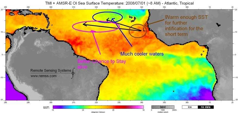
Current SST, you can clearly see that where the NRL has a broad surface low centered is over at least 82 degree waters over the next 48 hrs it will stay over warm enough waters for intensification, if it gains latitude past the CV islands it will definitely encounter much cooler waters and stable airmass and start weakening, if it stays on a more westward track it should stay on marginal waters for at least to stay organized. I am not even to mention shear because is not a problem for the short term.
0 likes
Re: INVEST 92L in the Eastern Atlantic
Not sure if I should start a new topic, but, this is the EUMETSAT loop that includes the CV region and 92L:
http://oiswww.eumetsat.org/SDDI/cgi/lis ... v=400,pp=0
92L only shows modest convection, and, appears that it might already be interacting with dry air to the west, and, seems to be part of an ITCZ disturbance, so, it's understandable why the NHC is conservative when it comes to the future of 92L...
Frank
0 likes
-
curtadams
- S2K Supporter
- Posts: 1122
- Joined: Sun Aug 28, 2005 7:57 pm
- Location: Orange, California
- Contact:
Re: INVEST 92L in the Eastern Atlantic
Impressive rotation, but convection has weakened a lot since it came offshore. Coldest cloud temps have warmed from -80 to -65 or so.
0 likes


-
cheezyWXguy

- Category 5
- Posts: 6284
- Joined: Mon Feb 13, 2006 12:29 am
- Location: Dallas, TX
Re: INVEST 92L in the Eastern Atlantic
Dont get your hopes up that its about to die...it may not develop now, but its not likely to die now either. You all know about diurnal minimums, maximums and that stuff, and Im pretty sure its close to one of the diurnal minimums right now. Also, tropical waves tend to look ragged during their transitions from land to water, even if conditions of conductive for development...Ive seen it quite a lot.
0 likes
Who is online
Users browsing this forum: No registered users and 6 guests