
My gut feeling was right, then, it's a hurricane again.
Still one at 00z says ATCF:
AL, 02, 2008071900, , BEST, 0, 386N, 497W, 65, 989, HU, 34, NEQ, 110, 150, 110, 75, 1014, 325, 35, 0, 0, L, 0, , 0, 0, BERTHA, D,
AL, 02, 2008071900, , BEST, 0, 386N, 497W, 65, 989, HU, 50, NEQ, 35, 50, 35, 35, 1014, 325, 35, 0, 0, L, 0, , 0, 0, BERTHA, D,
AL, 02, 2008071900, , BEST, 0, 386N, 497W, 65, 989, HU, 64, NEQ, 0, 40, 0, 0, 1014, 325, 35, 0, 0, L, 0, , 0, 0, BERTHA, D,
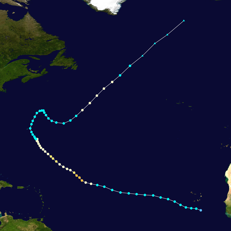
TC Bertha
Moderator: S2k Moderators


Bertha's resurgence could be over.
WTNT42 KNHC 190243
TCDAT2
HURRICANE BERTHA DISCUSSION NUMBER 64
NWS TPC/NATIONAL HURRICANE CENTER MIAMI FL AL022008
1100 PM EDT FRI JUL 18 2008
CONVECTION AROUND THE SOUTH SIDE OF BERTHA'S EYE HAS WEAKENED DURING
THE PAST SEVERAL HOURS. HOWEVER...DVORAK INTENSITY ESTIMATES ARE
UNCHANGED...SO BERTHA REMAINS A 65 KT HURRICANE. BERTHA IS NOT
EXPECTED TO BE A HURRICANE MUCH LONGER AS IT WILL BE MOVING OVER
PROGRESSIVELY COOLER WATERS WITHIN THEN NEXT 12-24 HOURS. THE
INTENSITY FORECAST CALLS FOR GRADUAL WEAKENING AS BERTHA
BECOMES EXTRATROPICAL IN 24-36 HOURS.
BERTHA CONTINUES TO ACCELERATE NORTHEASTWARD WITH A FORWARD SPEED
OF ABOUT 22 KT. BERTHA IS FORECAST TO REMAIN ON A NORTHEAST
HEADING DURING THE NEXT 2-3 DAYS. THE OFFICIAL FORECAST IS SIMILAR
TO THE PREVIOUS ADVISORY...BUT IS SLIGHTLY FASTER. HOWEVER...THE
NEW TRACK FORECAST IS A LITTLE SLOWER THAN THE GFS...BUT IS AHEAD
OF THE MODEL CONSENSUS. THE FORECAST 34 KT WIND RADII WERE
EXPANDED OUTWARD OVER THE EASTERN SEMICIRCLE IN GOOD AGREEMENT
WITH A BLEND OF THE GLOBAL MODELS.
FORECAST POSITIONS AND MAX WINDS
INITIAL 19/0300Z 39.5N 48.8W 65 KT
12HR VT 19/1200Z 42.0N 46.0W 60 KT
24HR VT 20/0000Z 45.4N 42.1W 55 KT...BECOMING EXTRATROPICAL
36HR VT 20/1200Z 50.2N 37.5W 50 KT...EXTRATROPICAL
48HR VT 21/0000Z 55.4N 32.1W 50 KT...EXTRATROPICAL
72HR VT 22/0000Z 63.5N 20.0W 45 KT...EXTRATROPICAL
96HR VT 23/0000Z...ABSORBED
$$
FORECASTER BROWN
0 likes
-
Matt-hurricanewatcher
Re: Hurricane Bertha in Western Atlantic
Ivan from 0-59 and starts up again at 67-73. That is 65 advisory's. I won't count the "inland" advisory's. So Bertha only needs to last intil 5am to tie Ivan. In 11am to beat him. The next storm it has to beat and will not is Kyle with 89 Advisory's.
http://www.nhc.noaa.gov/archive/2004/IVAN.shtml?
http://www.nhc.noaa.gov/archive/2002/KYLE.shtml
http://www.nhc.noaa.gov/archive/2004/IVAN.shtml?
http://www.nhc.noaa.gov/archive/2002/KYLE.shtml
0 likes
-
Matt-hurricanewatcher
Re: Hurricane Bertha in Western Atlantic
Looks like a 70 knot storm now. WOW, GO BERTHA GO. Hell the storm is heading for Iceland Monday 8pm.
0 likes
-
brunota2003

- S2K Supporter

- Posts: 9476
- Age: 35
- Joined: Sat Jul 30, 2005 9:56 pm
- Location: Stanton, KY...formerly Havelock, NC
- Contact:
WTNT42 KNHC 190830
TCDAT2
HURRICANE BERTHA DISCUSSION NUMBER 65
NWS TPC/NATIONAL HURRICANE CENTER MIAMI FL AL022008
500 AM EDT SAT JUL 19 2008
BERTHA HAS REMARKABLY MAINTAINED ITS TROPICAL STRUCTURE WITH AN EYE
SURROUNDED BY MODERATE CONVECTION. INITIAL INTENSITY IS KEPT AT 65
KNOTS BUT COULD BE A LITTLE BIT HIGHER...AS SUGGESTED BY DVORAK
ESTIMATES FROM TAFB. I AM NOT GOING TO SPECULATE HOW MUCH LONGER
BERTHA WILL KEEP ITS STRUCTURE BUT THE CYCLONE IS MOVING OVER COOL
WATERS AND WITHIN THE MID-LATITUDE FLOW. CONSQUENTLY...BERTHA HAS
TO WEAKEN AND BEGIN TO BECOME EXTRATROPICAL...FAMOUS LAST WORDS.
BERTHA IS MOVING TOWARD THE NORTHEAST OR 030 DEGREES AT 22 KNOTS.
THE HURRICANE SHOULD CONTINUE ON THIS GENERAL TRACK WITH A GRADUAL
INCREASE IN FORWARD SPEED UNTIL BECOME ABSORBED IN A COUPLE OF
DAYS. TRACK GUIDANCE UNANIMOUSLY SHOWS THE HURRICANE ACCELERATING
TOWARD THE NORTHEAST.
FORECAST POSITIONS AND MAX WINDS
INITIAL 19/0900Z 41.2N 47.4W 65 KT
12HR VT 19/1800Z 43.8N 44.8W 60 KT
24HR VT 20/0600Z 48.0N 40.5W 50 KT...EXTRATROPICAL
36HR VT 20/1800Z 53.0N 35.0W 50 KT...EXTRATROPICAL
48HR VT 21/0600Z 58.0N 28.0W 50 KT...EXTRATROPICAL
72HR VT 22/0600Z...EXTRATROPICAL
$$
FORECASTER AVILA
0 likes

-
brunota2003
- S2K Supporter
- Posts: 9476
- Age: 35
- Joined: Sat Jul 30, 2005 9:56 pm
- Location: Stanton, KY...formerly Havelock, NC
- Contact:


-
Extremeweatherguy

- Category 5

- Posts: 11095
- Joined: Mon Oct 10, 2005 8:13 pm
- Location: Florida
-
Ed Mahmoud
Re: Hurricane Bertha in Western Atlantic
I wonder if the extra-tropical remains of Bertha will result in a strong July ocean storm for somehwere in Europe.
0 likes
-
Cryomaniac
- Category 5
- Posts: 1289
- Joined: Tue Aug 15, 2006 2:26 pm
- Location: Newark, Nottinghamshire, UK
- Contact:
Re: Hurricane Bertha in Western Atlantic
Ed Mahmoud wrote:I wonder if the extra-tropical remains of Bertha will result in a strong July ocean storm for somehwere in Europe.
I said that earlier in the thread, I think it will hit the UK while ET.
0 likes
Who is online
Users browsing this forum: No registered users and 37 guests