ATL: Tropical Depression Edouard

Moderator: S2k Moderators

Message
Author
Ed Mahmoud

Re:

#421 Postby Ed Mahmoud » Sun Aug 03, 2008 9:04 am

Derek Ortt wrote:doesn't matter if it is a short flight

no need to waste flight hours on a system that we can determine is not developing based upon obs


Just my amateur opinion, mind you, but based on satellite, a circulation may (or may not) have worked its way to the surface by early afternoon when recon would be out there.
0 likes   

User avatar
lrak
S2K Supporter
S2K Supporter
Posts: 1770
Age: 58
Joined: Thu Jun 21, 2007 2:48 pm
Location: Corpus Christi, TX

Re: Re:

#422 Postby lrak » Sun Aug 03, 2008 9:07 am

Ed Mahmoud wrote:
Derek Ortt wrote:doesn't matter if it is a short flight

no need to waste flight hours on a system that we can determine is not developing based upon obs


Just my amateur opinion, mind you, but based on satellite, a circulation may (or may not) have worked its way to the surface by early afternoon when recon would be out there.


I'm a 25 year amateur and the visible loops shows a circulation. Low level, mid level or surface level. :D
0 likes   

xironman
S2K Supporter
S2K Supporter
Posts: 2522
Joined: Sun Jun 10, 2007 4:53 pm
Location: NoVA

Re: ATL: Invest 91L - Gulf of Mexico

#423 Postby xironman » Sun Aug 03, 2008 9:08 am

at about 28.7n 87W the visible satellite loop gives the illusion of a spin for sure.

Sure looks that way to me as well http://wwwghcc.msfc.nasa.gov/cgi-bin/get-goes?satellite=GOES-E%20CONUS&lat=28.5&lon=-87&zoom=1&info=vis&type=Animation&numframes=8&quality=90 maybe it will work its way down to the surface. The shear looks to be less as time goes on as well.
0 likes   

Ed Mahmoud

Re: ATL: Invest 91L - Gulf of Mexico

#424 Postby Ed Mahmoud » Sun Aug 03, 2008 9:09 am

WxMan57 - I never worked in the North Sea, but I have seen TV footage of conditions that were probably close to Cat 1 hurricane wind and waves.


Of course, we all know the story of the Ocean Ranger offshore Canada. But at least all Diamond Offshore rigs have survival suits. In the winter months, one can get hypothermia in the Gulf. In August, take a long time to freeze to death in 30º C water. Drowning and marine predators, I'd guess, would be more pressing concerns.
0 likes   

User avatar
KatDaddy
Category 5
Category 5
Posts: 2815
Joined: Mon Oct 21, 2002 6:23 pm
Location: League City, Texas

#425 Postby KatDaddy » Sun Aug 03, 2008 9:09 am

Gale Warnings also hoisted offshore of SE LA

COASTAL WATERS FORECAST
NATIONAL WEATHER SERVICE NEW ORLEANS LA
435 AM CDT SUN AUG 3 2008

PASCAGOULA TO ATCHAFALAYA RIVER OUT 60 NM

GMZ575-040030-
/O.NEW.KLIX.GL.W.0005.080804T0000Z-080804T1200Z/
COASTAL WATERS FROM PASCAGOULA MS TO THE SOUTHWEST PASS OF THE
MISSISSIPPI RIVER FROM 20 TO 60 NM-
435 AM CDT SUN AUG 3 2008

...GALE WARNING IN EFFECT FROM THIS EVENING THROUGH MONDAY
MORNING...

.TODAY...NORTH WINDS 20 TO 30 KNOTS. SEAS 4 TO 6 FEET BUILDING TO
7 TO 10 FEET IN THE AFTERNOON. NUMEROUS SHOWERS AND
THUNDERSTORMS. SOME THUNDERSTORMS MAY BE SEVERE.
.TONIGHT...SOUTHEAST WINDS 30 TO 35 KNOTS. GUSTS UP TO 50 KNOTS.
SEAS 6 TO 9 FEET BUILDING TO 8 TO 11 FEET AFTER MIDNIGHT.
SCATTERED SHOWERS AND THUNDERSTORMS.
.MONDAY...SOUTHEAST WINDS 30 KNOTS WITH GUSTS TO AROUND 50 KNOTS
EASING TO 15 TO 20 KNOTS WITH GUSTS TO AROUND 30 KNOTS LATE IN
THE AFTERNOON. SEAS 8 TO 11 FEET SUBSIDING TO 6 TO 8 FEET IN THE
AFTERNOON. SCATTERED SHOWERS AND THUNDERSTORMS.
0 likes   

User avatar
lrak
S2K Supporter
S2K Supporter
Posts: 1770
Age: 58
Joined: Thu Jun 21, 2007 2:48 pm
Location: Corpus Christi, TX

Re: ATL: Invest 91L - Gulf of Mexico

#426 Postby lrak » Sun Aug 03, 2008 9:10 am

I like the reality Crab Flick.
0 likes   

User avatar
mpic
S2K Supporter
S2K Supporter
Posts: 622
Joined: Thu Oct 20, 2005 11:24 am
Location: Splendora, TX

Re: ATL: Invest 91L - Gulf of Mexico

#427 Postby mpic » Sun Aug 03, 2008 9:12 am

I can understand not wanting to "waste" a recon flight, but when you live in a mobile home only 20 miles inland from the Gulf, you want as much info as possible.

I heard something about the possibility of using subs to go under storms to determine what's going on at some future date...not this one. Is there anything to that? A different way to predict storms more accurately?
0 likes   

User avatar
wxman57
Moderator-Pro Met
Moderator-Pro Met
Posts: 22978
Age: 67
Joined: Sat Jun 21, 2003 8:06 pm
Location: Houston, TX (southwest)

Re: ATL: Invest 91L - Gulf of Mexico

#428 Postby wxman57 » Sun Aug 03, 2008 9:13 am

My eye is drawn toward 28N/87.5W on the satellite loops. But surface obs indicate nothing there yet. The rotation is aloft.
0 likes   

User avatar
wxman57
Moderator-Pro Met
Moderator-Pro Met
Posts: 22978
Age: 67
Joined: Sat Jun 21, 2003 8:06 pm
Location: Houston, TX (southwest)

Re: ATL: Invest 91L - Gulf of Mexico

#429 Postby wxman57 » Sun Aug 03, 2008 9:16 am

mpic wrote:I can understand not wanting to "waste" a recon flight, but when you live in a mobile home only 20 miles inland from the Gulf, you want as much info as possible.

I heard something about the possibility of using subs to go under storms to determine what's going on at some future date...not this one. Is there anything to that? A different way to predict storms more accurately?


That's an interesting idea. A recon sub. It could stay in the center of a storm for weeks, if necessary, probing surface pressure or maybe move to the eyewall to measure surface winds with a tethered anemometer while remaining submerged. Unfortunately, there's barely money to fly a recon plane out there. So the sub idea will have to wait.
0 likes   

User avatar
NDG
S2K Supporter
S2K Supporter
Posts: 15446
Joined: Sun Jul 09, 2006 10:14 pm
Location: Orlando, FL

#430 Postby NDG » Sun Aug 03, 2008 9:16 am

Surface obs surely does not matches yet what I see on Vis sat loopImage
Image
Last edited by NDG on Sun Aug 03, 2008 9:22 am, edited 1 time in total.
0 likes   

User avatar
MGC
S2K Supporter
S2K Supporter
Posts: 5899
Joined: Sun Mar 23, 2003 9:05 pm
Location: Pass Christian MS, or what is left.

Re: ATL: Invest 91L - Gulf of Mexico

#431 Postby MGC » Sun Aug 03, 2008 9:20 am

The following post is NOT an official forecast and should not be used as such. It is just the opinion of the poster and may or may not be backed by sound meteorological data. It is NOT endorsed by any professional institution including storm2k.org For Official Information please refer to the NHC and NWS products.

Looks like there is a circulation at 28N 87W. The northern part is exposed with the convection limited to the southern semicircle. Once a few more satellite frames are in to confirm the circulation, the NHC will decide to send recon. Chances are recon will find a weak depression. Given the proxcimity to land it should be upgraded provided the convection remains. I don't expect any rapid intensification due to dry air, only slow intensification. It will have a good shot at getting named as it approaches the western GOM......MGC
0 likes   

xironman
S2K Supporter
S2K Supporter
Posts: 2522
Joined: Sun Jun 10, 2007 4:53 pm
Location: NoVA

Re: ATL: Invest 91L - Gulf of Mexico

#432 Postby xironman » Sun Aug 03, 2008 9:23 am

42040 back east again http://www.ndbc.noaa.gov/station_page.php?station=42040, lets see if it holds.
0 likes   

User avatar
lrak
S2K Supporter
S2K Supporter
Posts: 1770
Age: 58
Joined: Thu Jun 21, 2007 2:48 pm
Location: Corpus Christi, TX

Re: ATL: Invest 91L - Gulf of Mexico

#433 Postby lrak » Sun Aug 03, 2008 9:24 am

this looks like that little Dolly spin we all watched form up :D
0 likes   

njweather
Tropical Storm
Tropical Storm
Posts: 169
Joined: Fri Aug 17, 2007 10:45 pm
Location: Washington, DC

Re: ATL: Invest 91L - Gulf of Mexico

#434 Postby njweather » Sun Aug 03, 2008 9:28 am

For what it's worth (a little over an hour old):

Image
0 likes   

User avatar
cycloneye
Admin
Admin
Posts: 145308
Age: 68
Joined: Thu Oct 10, 2002 10:54 am
Location: San Juan, Puerto Rico

Re: ATL: Invest 91L - Gulf of Mexico

#435 Postby cycloneye » Sun Aug 03, 2008 9:31 am

In the next hour we will know if the plane departs or not to investigate 91L.
0 likes   

User avatar
KWT
Category 5
Category 5
Posts: 31415
Joined: Tue Aug 17, 2004 11:02 am
Location: UK!!!

#436 Postby KWT » Sun Aug 03, 2008 9:35 am

Yeah 87-87.5W is looking very interesting have to admit you can see the clouds streaming in from the south but not sure if its at the surface, it does look very interesting...why some people think recon shouldn't go in is beyond me given that feature!
0 likes   

User avatar
HURAKAN
Professional-Met
Professional-Met
Posts: 46086
Age: 38
Joined: Thu May 20, 2004 4:34 pm
Location: Key West, FL
Contact:

#437 Postby HURAKAN » Sun Aug 03, 2008 9:42 am

Image

Image
0 likes   

njweather
Tropical Storm
Tropical Storm
Posts: 169
Joined: Fri Aug 17, 2007 10:45 pm
Location: Washington, DC

Re: ATL: Invest 91L - Gulf of Mexico

#438 Postby njweather » Sun Aug 03, 2008 9:51 am

Latest quickscat (6 minutes old):

Image
0 likes   

User avatar
Chacor
Category 5
Category 5
Posts: 10229
Joined: Mon Oct 02, 2006 10:43 pm
Location: Singapore

#439 Postby Chacor » Sun Aug 03, 2008 9:53 am

The pass is from 1150z. It's not six minutes old. The two quickscat passes you posted are the same, only with a different buffer time.
Last edited by Chacor on Sun Aug 03, 2008 9:54 am, edited 1 time in total.
0 likes   

User avatar
vbhoutex
Storm2k Executive
Storm2k Executive
Posts: 29112
Age: 73
Joined: Wed Oct 09, 2002 11:31 pm
Location: Cypress, TX
Contact:

Re: ATL: Invest 91L - Gulf of Mexico

#440 Postby vbhoutex » Sun Aug 03, 2008 9:53 am

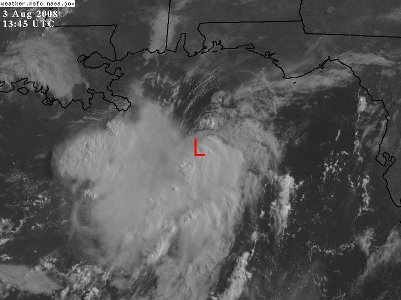
A check of all of the reporting bouys within the area around the possible circulation does indeed indicate by wind direction that there is a surface circulation at least attempting to develop. However the pressures are steady at most of the stations but may be lower than normal(I'm not sure of this-they seem lower than normal to me)and we will have to see pressure falls begin and continue relatively soon if this is going to try and develop today.

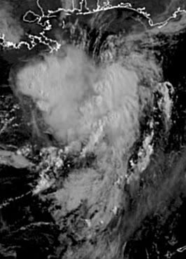
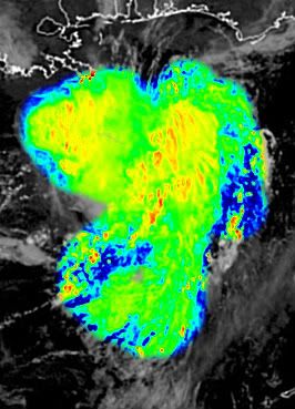
The sat loops, at initial viewing, definitely indicate a mid level circulation, but with my still not completely open eyes, I did not see a definitel LLC in the lower clouds. Again, I think we are stil looking at stacking issues here, even without a lot of shear impacting the system.

Definitely going to be monitoring this one all day long.
0 likes   


Return to “2008”

Who is online

Users browsing this forum: No registered users and 6 guests