ATL: Tropical Depression Edouard

Moderator: S2k Moderators

Message
Author
User avatar
HouTXmetro
Category 5
Category 5
Posts: 3949
Joined: Sun Jun 13, 2004 6:00 pm
Location: District of Columbia, USA

Re: ATL: Invest 91L - Gulf of Mexico

#41 Postby HouTXmetro » Sat Aug 02, 2008 2:35 pm

perk wrote:The first position issued on Alicia was 27.3n/ 90.5w. at 1009 milibars.


91L is not as far south but has much more Real Estate should He/She decides to get it's act together.
0 likes   

RL3AO
Moderator-Pro Met
Moderator-Pro Met
Posts: 16308
Joined: Thu Jun 14, 2007 10:03 pm
Location: NC

Re:

#42 Postby RL3AO » Sat Aug 02, 2008 2:36 pm

KWT wrote:Well the last 24hrs track has shown this systemto have been moving in a SW direction but still perk Alicia was quite a bit further south when it started.


Alicia started at 27.3N. This is at 29.5N.
0 likes   

User avatar
TexWx
Category 1
Category 1
Posts: 370
Joined: Tue Aug 22, 2006 11:00 pm
Location: Pearland, Texas
Contact:

Re: ATL: Invest 91L - Gulf of Mexico

#43 Postby TexWx » Sat Aug 02, 2008 2:36 pm

0 likes   

User avatar
gboudx
S2K Supporter
S2K Supporter
Posts: 4047
Joined: Thu Sep 04, 2003 1:39 pm
Location: Rockwall, Tx but from Harvey, La

#44 Postby gboudx » Sat Aug 02, 2008 2:37 pm

We're planning a trip to Galveston next Wed-Fri. Oh boy.
0 likes   

rockyman
Category 5
Category 5
Posts: 1967
Joined: Thu Jun 26, 2003 12:24 pm
Location: Dauphin Island, AL

#45 Postby rockyman » Sat Aug 02, 2008 2:39 pm

From Wikipedia:
http://en.wikipedia.org/wiki/Hurricane_Alicia

A mesoscale low formed off the Alabama and Mississippi coasts on August 14 with a weak frontal trough that had formed off New England. Pressures were high in the Gulf of Mexico, but the low strengthened into Tropical Depression Three on August 15. A ship located within 60 miles (97 km) of the depression reported a pressure of 1015.5 millibars, and the storm was upgraded to Tropical Storm Alicia late on August 15. With the high Gulf pressures, Alicia was unable to gain size, staying very small, but generated faster winds, and became a Category 1 hurricane on August 16. Steering currents were weak during Alicia's lifetime over water. A new frontal ridge had formed on August 17 which caused the storm to drift in a westerly direction.[1] Alicia continued west until the frontal ridge had subsided to the east.[4] Alicia turned to a more northerly direction on August 18, towards Port Arthur, Texas. During that time, the hurricane began to gain strength at about 1 mbar an hour, peaking at 963 mbar with winds of 115 mph (185 km/h) on the morning of the 18th. Just before landfall, Alicia exhibited a rare "double eye" feature for several hours.[5] The storm made landfall near Galveston, Texas as a Category 3 hurricane at about 1:45 a.m. CDT on Thursday, August 18.[1] Alicia weakened rapidly after landfall, losing tropical characteristics and accelerated to the northwest, finally losing its identity in the southeast tip of Nebraska on August 21.[1]
0 likes   

User avatar
SouthFloridawx
S2K Supporter
S2K Supporter
Posts: 8344
Age: 45
Joined: Tue Jul 26, 2005 1:16 am
Location: Sarasota, FL
Contact:

Re: ATL: Invest 91L - Gulf of Mexico

#46 Postby SouthFloridawx » Sat Aug 02, 2008 2:40 pm

Image

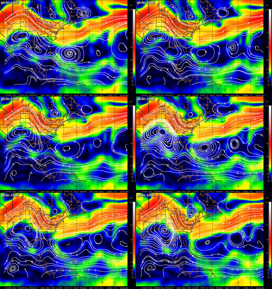
Weak Steering currents right now... perhaps a Slow Southerly Motion for now.

Image

250 - 850mb Steering flow last 24 hours:

Image
Last edited by SouthFloridawx on Sat Aug 02, 2008 2:42 pm, edited 1 time in total.
0 likes   

User avatar
HouTXmetro
Category 5
Category 5
Posts: 3949
Joined: Sun Jun 13, 2004 6:00 pm
Location: District of Columbia, USA

#47 Postby HouTXmetro » Sat Aug 02, 2008 2:41 pm

Shoul 91L Drift SW it could very well cross the same area where Alicia started.
0 likes   

Stormcenter
S2K Supporter
S2K Supporter
Posts: 6617
Joined: Wed Sep 03, 2003 11:27 am
Location: Houston, TX

Re: ATL: Invest 91L - Gulf of Mexico

#48 Postby Stormcenter » Sat Aug 02, 2008 2:48 pm

It's pretty obvious this system is getting it's act together pretty quickly.

http://www.ssd.noaa.gov/goes/east/gmex/loop-avn.html
0 likes   

User avatar
perk
Category 3
Category 3
Posts: 825
Joined: Mon Aug 09, 2004 9:35 am
Location: Richmond Texas

Re:

#49 Postby perk » Sat Aug 02, 2008 2:50 pm

KWT wrote:Well the last 24hrs track has shown this systemto have been moving in a SW direction but still perk Alicia was quite a bit further south when it started.

I would not argue that point. :D
0 likes   

Bailey1777
S2K Supporter
S2K Supporter
Posts: 962
Joined: Mon Jul 31, 2006 6:23 pm
Location: Houston, Texas

#50 Postby Bailey1777 » Sat Aug 02, 2008 2:51 pm

Any sign of a closed LLC yet?
0 likes   

User avatar
KatDaddy
Category 5
Category 5
Posts: 2815
Joined: Mon Oct 21, 2002 6:23 pm
Location: League City, Texas

#51 Postby KatDaddy » Sat Aug 02, 2008 2:52 pm

Very much shades of Alicia. The Houston-Galveston areas are going on the longest timespan between being directly affected by a major hurricane 25 years and counting and our luck will run out sooner than later I believe.
Not say this Invest will be the one but the N GOM is very warm. I did a check around the house and yard as well as check the screw insets for the panels.

Very important info for anyone that has storm panels with brick insets.

Make sure the insets are clear of mud from insects. It took me a full day to clean the insets. You dont want be dealing with that task when you putting up panels.

I would rather be prepared in case anythng surprising comes from the Invest. Personally I hoping for well needed rainfall.
0 likes   

User avatar
perk
Category 3
Category 3
Posts: 825
Joined: Mon Aug 09, 2004 9:35 am
Location: Richmond Texas

Re:

#52 Postby perk » Sat Aug 02, 2008 2:58 pm

KatDaddy wrote:Very much shades of Alicia. The Houston-Galveston areas are going on the longest timespan between being directly affected by a major hurricane 25 years and counting and our luck will run out sooner than later I believe.
Not say this Invest will be the one but the N GOM is very warm. I did a check around the house and yard as well as check the screw insets for the panels.

Very important info for anyone that has storm panels with brick insets.

Make sure the insets are clear of mud from insects. It took me a full day to clean the insets. You dont want be dealing with that task when you putting up panels.

I would rather be prepared in case anythng surprising comes from the Invest. Personally I hoping for well needed rainfall.
Katdaddy i brought the old generator a couple of weeks ago to make sure it was running properly.
0 likes   

User avatar
PTrackerLA
Category 5
Category 5
Posts: 5248
Age: 40
Joined: Thu Oct 10, 2002 8:40 pm
Location: Lafayette, LA

Re: ATL: Invest 91L - Gulf of Mexico

#53 Postby PTrackerLA » Sat Aug 02, 2008 3:01 pm

I'm completely stunned. I took a 36 hour break from checking out the tropics and log on to find THIS! Looks very impressive on visible satellite. Like all have said we could use the rain so hopefully this doesn't become much more.
0 likes   

MiamiensisWx

Re: ATL: Invest 91L - Gulf of Mexico

#54 Postby MiamiensisWx » Sat Aug 02, 2008 3:04 pm

The following post is NOT an official prognosis.

I believe there is adept and solid support for future tropical cyclogenesis from this system in the west-central Gulf of Mexico. Currently, a weak H5 shortwave trough is departing ENE of the system over the Southeast, while a longwave trough remains in place over the Great Lakes and Northeast. As the shortwave moves ENE, upper level divergence will be good over the system, while an upper low to the SE over Cuba will induce ideal ventilation and outflow. In the Pacific, as the Aleutian low and associated vorticity maximum deepens/intensifies at H5, an Omega block should amplify and build north over southern Alaska. At the same time, the downstream H5 longwave trough over western Canada will shift east, allowing an eastward expansion of the large ridge over the Southwestern United States. Consequently, the upper level wind vectors at 250-500 mb and the LL/ML steering currents will allow a slow SW drift of the system over the next 24-48+ hours.

Currently, as seen on GOES visible imagery, the system is encountering northerly shear on the eastern side of the UL ridge. This will inhibit development within the short term. As the system drifts further SW over the next few days, northerly shear should decrease as the ridge moves east and the wind vectors shift to the NE and ENE. With a weakening TUTT to the SE providing decent ventilation, intensification will likely take place at this point. Proximity to land won't be an issue; many TCs across the basin and GOM have developed and deepened very close to land, as evidenced by Jerry 1989, Danny 1997, Humberto 2007, and others. I definitely believe we will likely eventually witness TD (and TS) classification. Depending on inner core processes, it is possible that the system could approach strong TS or hurricane intensity. The most significant negative factor will likely be mid level dry air.

It is important to note that the upper level regime will not feature the classical H25-H3 anticyclonic flow and juxtaposition of an upper level jet that often results in TCs rapidly intensifying (i.e. Dean 2007, Emily 2005, Katrina 2005, etc.). It's not a "textbook" set-up for a TC strengthening to a major (Cat 3+) hurricane. This set-up was present during Dolly, and it will not occur during this system's life span. Based on this fact and the adjacent mid level dry air, I highly doubt this system will intensify beyond a high end TS or low end hurricane (at most). Although oceanic heat content, the depth of the 26 C isotherm, and SSTs are conducive, the upper air regime is far more important, and the pattern does not favor explosive intensification or even a Dolly-esque scenario. Overall, this system is not very reminescent of Alicia. However, I believe it is quite possible that we could see an intensifying strong TS or low end Category 1 like Jerry 1989 or Danny 1997. Those systems can be quite damaging, especially if they are strengthening, since stronger convection mixes higher winds more efficiently to the surface.

The bottom line is that residents in Texas should closely monitor this one. Remember that Category 1 winds are quite intense.
0 likes   

User avatar
HouTXmetro
Category 5
Category 5
Posts: 3949
Joined: Sun Jun 13, 2004 6:00 pm
Location: District of Columbia, USA

#55 Postby HouTXmetro » Sat Aug 02, 2008 3:06 pm

Outflow looks decent to the SE
0 likes   

User avatar
HURAKAN
Professional-Met
Professional-Met
Posts: 46086
Age: 37
Joined: Thu May 20, 2004 4:34 pm
Location: Key West, FL
Contact:

Re: ATL: Invest 91L - Gulf of Mexico

#56 Postby HURAKAN » Sat Aug 02, 2008 3:07 pm

Image

Image
0 likes   

RL3AO
Moderator-Pro Met
Moderator-Pro Met
Posts: 16308
Joined: Thu Jun 14, 2007 10:03 pm
Location: NC

Re:

#57 Postby RL3AO » Sat Aug 02, 2008 3:10 pm

Bailey1777 wrote:Any sign of a closed LLC yet?


There is no sign of a LLC much less a closed one.
0 likes   

Weatherfreak000

#58 Postby Weatherfreak000 » Sat Aug 02, 2008 3:11 pm

Three storms with decent chances to obtain TS Status...


Now..I wonder what all those kids who claimed the rest of the season was going to be boring and we wouldn't see a storm till Late August are thinking..
0 likes   

HurricaneRobert
Category 3
Category 3
Posts: 812
Joined: Fri May 18, 2007 9:31 pm

Re: ATL: Invest 91L - Gulf of Mexico

#59 Postby HurricaneRobert » Sat Aug 02, 2008 3:12 pm

A little north, but it does look like the system that formed Alicia.

http://www.ncdc.noaa.gov/gibbs/image/GOE-5/IR/1983-08-14-00
0 likes   

Stormcenter
S2K Supporter
S2K Supporter
Posts: 6617
Joined: Wed Sep 03, 2003 11:27 am
Location: Houston, TX

Re:

#60 Postby Stormcenter » Sat Aug 02, 2008 3:13 pm

Weatherfreak000 wrote:Three storms with decent chances to obtain TS Status...


Now..I wonder what all those kids who claimed the rest of the season was going to be boring and we wouldn't see a storm till Late August are thinking..


I'm not so sure about the other two.
0 likes   


Return to “2008”

Who is online

Users browsing this forum: No registered users and 8 guests