ATL: Tropical Storm Cristobal in North Atlantic

Moderator: S2k Moderators

Message
Author
User avatar
cheezyWXguy
Category 5
Category 5
Posts: 5569
Joined: Mon Feb 13, 2006 12:29 am
Location: Dallas, TX

Re: ATL: INVEST 96L near Southeast US

#41 Postby cheezyWXguy » Thu Jul 17, 2008 3:39 pm

Ed Mahmoud wrote:The first run of SHIPs didn't seem overly impressed with strengthening potential. Not sure why. Perhaps the dry air to its West.

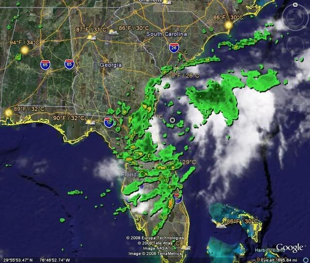
SHIPS is run off of the bam models, which bring the system into the carolina coast, which doesnt appear to be likely, as it is moving very slowly to the NNE. And probably the reason for a bare western side could be that land is cutting off inflow/outflow, much how south america is cutting off 94L's inflow/outflow.
0 likes   

OuterBanker
S2K Supporter
S2K Supporter
Posts: 1706
Joined: Wed Feb 26, 2003 10:53 am
Location: Nags Head, NC
Contact:

#42 Postby OuterBanker » Thu Jul 17, 2008 3:40 pm

Seems to me that 96L is drifting nne if moving at all. Actually just looks like it's spinning up in place. It should go nowhere for awhile. Not looking good for the Carolinas I'm afraid. Rain would be good, but it will probably just affect the eastern areas of the state. Originally, this was supposed the go from the panhandle north giving central Ga, SC, NC much needed rain. Those areas are probably going to miss out. Now, this has a real chance to spin up. JB is concerned for Ga and mostly NC. He states that there is no reason for this to go inland for at least 60 hrs. I hope he's wrong.
0 likes   

HurricaneHunter914
Category 5
Category 5
Posts: 4439
Age: 30
Joined: Fri Mar 10, 2006 7:36 pm
Location: College Station, TX

Re: ATL: INVEST 96L near Southeast US

#43 Postby HurricaneHunter914 » Thu Jul 17, 2008 3:41 pm

Stratosphere747 wrote:17/1745 UTC 30.5N 80.3W TOO WEAK INVEST -- Atlantic Ocean

They gave 94L 2.5 yesterday, yet they call this system with a good tight circulation too weak. Not bashing, but I think 96L deserves at the least, a 1.0.
0 likes   

User avatar
jdray
Category 3
Category 3
Posts: 846
Joined: Tue Aug 31, 2004 10:07 pm
Location: NE Florida

Re: ATL: INVEST 96L near Southeast US

#44 Postby jdray » Thu Jul 17, 2008 3:43 pm

000
FXUS62 KJAX 171907
AFDJAX

AREA FORECAST DISCUSSION
NATIONAL WEATHER SERVICE JACKSONVILLE FL
307 PM EDT THU JUL 17 2008

...LOCALLY HEAVY RAINFALL TONIGHT POSSIBLE EASTERN ZONES THIS
EVENING...

.SYNOPSIS...SFC ANALYSIS AND VIS IMAGERY CONT TO SHOW SFC LOW OFF
THE COAST NEAR 31N81W WITH TROUGH AXIS SW INTO CENTRAL FL. THETAE
MAXIMUM IS LOCATED OVER THE COASTAL SE GA AREA TO OUR INTERIOR NE FL
ZONES. RADAR HAS BEEN VERY ACTIVE BUT LITTLE IN THE WAY OF
THUNDERSTORMS SO FAR AS TEMPS HAVE BEEN STRUGGLING TO MAKE 80 DEG
ERN ZONES AND MANAGING THE UPPER 80S OVER WELL INTERIOR ZONES WHERE
MORE SUN IS OCCURRING. UPPER LEVELS SHOW HIGH PRESSURE RIDGE AT 250 MB
IN NE FL AND SE GA AND LOW TO MID LEVELS DOMINATED BY A TROUGH FROM
OFF THE W CENTRAL FL COAST TO CYCLONIC CIRCULATION NEAR 31N81W AND
NE INTO OFF THE NC COAST.


.SHORT TERM...
TONIGHT...MODELS ARE IN MUCH BETTER AGREEMENT THAT THE SFC LOW WILL
TRACK SLOWLY NWD
. NAM IS MORE OPTIMISTIC ABOUT DRIER AIR MOVING IN ON
THE BACK SIDE OF THE LOW OVER GA WHICH MAY BE CORRECT. IN GENERAL
THE MODEL FORECASTS ARE NOT TOO DIFFERENT AND WILL GO WITH A LIKELY
POP NEAR THE COAST N OF JAX FOR TONIGHT WITH SLIGHT CHANCE TO LOW
END CHANCE INLAND AREAS WHERE THE DRIER AIR WILL TRY TO FILTER IN ON
NELY FLOW ALOFT. WILL CONT WITH LOCALLY HEAVY RAINFALL BUT FOR
MAINLY THE COAST. FRIDAY...SFC LOW WILL LIKELY TRACK UP INTO THE
GA/SC WATERS WITH A SFC TROUGH EXTENDING SW-NE ACROSS THE CWA.
WILL
INDICATE THE BEST CHANCE NEAR AND E OF THE TROUGH WHERE GOOD LIFTING
BELOW 500 MB IS NOTED...BUT NOT MORE THAN 60% CHANCE. NW OF THE
TROUGH AROUND 40-50% CHANCE. STILL SOME UNCERTAINTY WITH REGARD TO
THE TRACK OF THE LOW WHICH HAS IMPLICATIONS ON THE POPS SO
CONFIDENCE IS NOT HIGH. IN FACT A FEW SOLUTIONS SHOW THE LOW MOVING
NNW.
HIGHS TEMPS SHOULD BE A BIT WARMER IN THE MID AND UPPER 80S
AREA-WIDE SO STILL BELOW CLIMO VALUES. FRIDAY NIGHT...THE LOW IS
EXPECTED TO SHIFT NNEWD BASED ON MODEL CONSENSUS WITH DEEP LAYER
MOISTURE CONTINUING TO DECREASE GRADUALLY. MID LEVEL RIDGE WILL
BUILD INTO CENTRAL FL. POPS AROUND 20-30% PLANNED FOR MAINLY EVENING
HOURS. SATURDAY...FAIRLY MOIST SWLY FLOW AND AFTERNOON INSTABILITY
EXPECTED TO PRODUCE RAIN CHANCES AROUND 30-40%. MORE FAVORED AREA
MAY BE SE GA AND THE COASTAL AREAS DUE TO HIGHER MOISTURE CONTENT
AND SEA BREEZE CONVERGENCE. MAX TEMPS IN THE LOWER 90S EXPECTED.
SATURDAY NIGHT...EXPECT CONVECTION TO DISSIPATE WITH LOSS OF HEATING
AND THE CONTINUED DECREASING PWAT VALUES LIKELY BELOW 1.8 INCHES.
SUNDAY...MID LEVEL RIDGE WILL BE ACROSS CENTRAL FL RESULTING IN MEAN
FLOW FROM THE W. THIS WOULD FAVOR A LOWER POP REGIME AND WILL INSERT
20% AT THIS TIME. TEMPS EXPECTED TO PUSH INTO THE LOWER TO MID 90S.


Looks like this one still needs some model work before they can be sure.
Either way, the rain has a "tropical" feel to it. I just drove home in it.
0 likes   

User avatar
KWT
Category 5
Category 5
Posts: 31391
Joined: Tue Aug 17, 2004 11:02 am
Location: UK!!!

#45 Postby KWT » Thu Jul 17, 2008 3:43 pm

I agree Derek IMO this could easily become a decent TS if it gets the time to do so over the gulf waters...interestingly even if t doesn't form now it will have a real good chance if it can stay over water or get back over water if it goes inland.
0 likes   

User avatar
Matt-hurricanewatcher
Category 5
Category 5
Posts: 11649
Age: 38
Joined: Fri Nov 26, 2004 11:09 pm
Location: Portland,OR
Contact:

Re: ATL: INVEST 96L near Southeast US

#46 Postby Matt-hurricanewatcher » Thu Jul 17, 2008 3:46 pm

The main difference between this year and 2005 is the invests are not developing into cyclones. Also the sst's are not nearly as hot! So theres a good chance it will be active season but not the extreme. Talk to all you later!
0 likes   

MWatkins
S2K Supporter
S2K Supporter
Posts: 2574
Joined: Sat Oct 12, 2002 7:51 pm
Location: SE Florida
Contact:

Re: ATL: INVEST 96L near Southeast US

#47 Postby MWatkins » Thu Jul 17, 2008 3:47 pm

Ed Mahmoud wrote:The first run of SHIPs didn't seem overly impressed with strengthening potential. Not sure why. Perhaps the dry air to its West.


The biggest negative contributors (in the SHIPS model) are:

Marginal SST's (26 to 27 degrees) through 60 hours or so...but we saw bertha go to town over similar temps...so perhaps the SST's aren't going to be as limiting as SHIPS suggests.

Lack of vorticity at 850MB (again, this could be iffy looking at the 12z model runs...clearly there is some vorticity in the environment based on the fact that this thing exists to begin with).

Lack of upper divergance at 200MB and inceasing shear by 120 hours.

They also put the forecast track on BAMM (which is out at 32/73 in 120)...so that is a bit suspect...don't think it will be that far out by then.

MW
0 likes   

Derek Ortt

#48 Postby Derek Ortt » Thu Jul 17, 2008 3:51 pm

Matt,

its not SST

there are totally different atmospheric parameters

SST is a necessary but not sufficient condition for development. And we have met the necessary threshold this season easily
0 likes   

User avatar
KWT
Category 5
Category 5
Posts: 31391
Joined: Tue Aug 17, 2004 11:02 am
Location: UK!!!

#49 Postby KWT » Thu Jul 17, 2008 3:58 pm

Yeah Derek Bertha survived over waters down to 24-25C, SSt's are more then high enough esp with the gulf stream nearby, I wonder how deep the warmer waters go mind you?

Still I think this has a real chance of developing, yep its a little lop-sided but we've seen loads of those sorts of looking systems near land get upgraded before.
0 likes   

User avatar
chadtm80
Category 5
Category 5
Posts: 20381
Age: 43
Joined: Tue Oct 08, 2002 8:35 am
Location: East Central Florida
Contact:

Re: ATL: INVEST 96L near Southeast US

#50 Postby chadtm80 » Thu Jul 17, 2008 4:00 pm

Image
0 likes   

category5

Re: ATL: INVEST 96L near Southeast US

#51 Postby category5 » Thu Jul 17, 2008 4:00 pm

unconfirmed report I heard: JB is now calling for a hurricane off the NC coast this weekend!

Question: Is this the remnants of the low that moved inland off the west coast of FL yesterday?
0 likes   

Ed Mahmoud

Re: ATL: INVEST 96L near Southeast US

#52 Postby Ed Mahmoud » Thu Jul 17, 2008 4:07 pm

category5 wrote:unconfirmed report I heard: JB is now calling for a hurricane off the NC coast this weekend!

Question: Is this the remnants of the low that moved inland off the west coast of FL yesterday?


Possible hurricane, and if it does make hurricane, per JB, it'll effect the trough enough to pull itself closer to New England after passing Hatteras. If it stays weak and doesn't start effecting the trouh over the lakes, it'll head NE away from land.

JB is not for sure predicting a hurricane. Just mentioning the possibility.


Reasonable precautions in coastal Carolinas seem prudent, but I wouldn't panic based on just JB.


In my unofficial opinion.
0 likes   

User avatar
storms in NC
S2K Supporter
S2K Supporter
Posts: 2338
Joined: Thu Jul 28, 2005 2:58 pm
Location: Wallace,NC 40 miles NE of Wilm
Contact:

Re: ATL: INVEST 96L near Southeast US

#53 Postby storms in NC » Thu Jul 17, 2008 4:08 pm

category5 wrote:unconfirmed report I heard: JB is now calling for a hurricane off the NC coast this weekend!

Question: Is this the remnants of the low that moved inland off the west coast of FL yesterday?


As warm as the waters are I can see a min Hurricane but not off the coast. This will come in at cape fear. JIMO
0 likes   

User avatar
KWT
Category 5
Category 5
Posts: 31391
Joined: Tue Aug 17, 2004 11:02 am
Location: UK!!!

#54 Postby KWT » Thu Jul 17, 2008 4:12 pm

I tel lyou waht this reminds me a little of Gaston 2004 and that didn't take long to get going over the warm waters that ar epresent. not saying it wil lget as strong a sit has a little less time but itys not totally imposssible for it to be a hurricane if it gets more time IMO.
0 likes   

User avatar
brunota2003
S2K Supporter
S2K Supporter
Posts: 9476
Age: 33
Joined: Sat Jul 30, 2005 9:56 pm
Location: Stanton, KY...formerly Havelock, NC
Contact:

Re: ATL: INVEST 96L near Southeast US

#55 Postby brunota2003 » Thu Jul 17, 2008 4:13 pm

storms in NC wrote:
category5 wrote:unconfirmed report I heard: JB is now calling for a hurricane off the NC coast this weekend!

Question: Is this the remnants of the low that moved inland off the west coast of FL yesterday?


As warm as the waters are I can see a min Hurricane but not off the coast. This will come in at cape fear. JIMO

Even if it did that, the eastern half would still be over water, which would maintain it's strength all the way up until in moved inland over Onslow or Carteret, then into the Pamlico Sound
0 likes   

User avatar
funster
Category 3
Category 3
Posts: 806
Joined: Sat Dec 29, 2007 4:27 pm
Location: North Dallas

Re: ATL: INVEST 96L near Southeast US

#56 Postby funster » Thu Jul 17, 2008 4:27 pm

brunota2003 wrote:
storms in NC wrote:
category5 wrote:unconfirmed report I heard: JB is now calling for a hurricane off the NC coast this weekend!

Question: Is this the remnants of the low that moved inland off the west coast of FL yesterday?


As warm as the waters are I can see a min Hurricane but not off the coast. This will come in at cape fear. JIMO

Even if it did that, the eastern half would still be over water, which would maintain it's strength all the way up until in moved inland over Onslow or Carteret, then into the Pamlico Sound


That does not sound like a good situation. Fortunately, we still have an unnamed disturbance at this point.
0 likes   

User avatar
HURAKAN
Professional-Met
Professional-Met
Posts: 46086
Age: 37
Joined: Thu May 20, 2004 4:34 pm
Location: Key West, FL
Contact:

#57 Postby HURAKAN » Thu Jul 17, 2008 4:47 pm

FROM DOWNTOWN JACKSONVILLE, FL:

Image

Image

Image
0 likes   

User avatar
storms in NC
S2K Supporter
S2K Supporter
Posts: 2338
Joined: Thu Jul 28, 2005 2:58 pm
Location: Wallace,NC 40 miles NE of Wilm
Contact:

#58 Postby storms in NC » Thu Jul 17, 2008 4:53 pm

Really if it does do any thing at the very most would be barley min hurricane. I think A Strong TS is what will happen which is fine with me all I want is the rain. The sea's can have the wind
0 likes   

User avatar
KWT
Category 5
Category 5
Posts: 31391
Joined: Tue Aug 17, 2004 11:02 am
Location: UK!!!

#59 Postby KWT » Thu Jul 17, 2008 4:55 pm

Yeah but a minimal hurricane can stil lcause serious issues, lest us forget what Katrina did as a cat-1 on its first landfall!

Right now I don't think it wil get that strong but I do think its got a good chance of development, the highest out of the 3 invests by quite some way at least for now, this really needs to be watched IMO even if it doesn't become too potent. I already said this could be similar to Gaston IMO.
0 likes   

User avatar
storms in NC
S2K Supporter
S2K Supporter
Posts: 2338
Joined: Thu Jul 28, 2005 2:58 pm
Location: Wallace,NC 40 miles NE of Wilm
Contact:

#60 Postby storms in NC » Thu Jul 17, 2008 5:19 pm

Gaston We didn't get much out of that one. We went fishing that day and watched it roll by.
0 likes   


Return to “2008”

Who is online

Users browsing this forum: No registered users and 7 guests