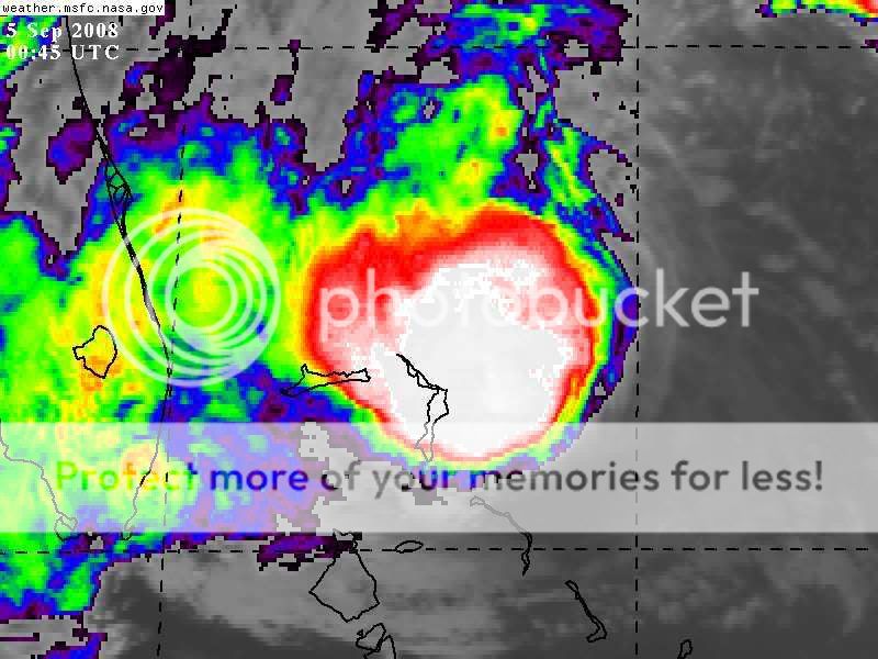
You can see the ULL clearly on the 200mb vort plots. hanna may have started pulling free of it just now but the N and NE flow (which is divergent and helping the convection) will remain until hanna gets far enough N to impart more E shear and the outflow pattern can allow development into a HC.
http://cimss.ssec.wisc.edu/tropic/real-time/atlantic/winds/wg8vor1.html
also the upper level anticyclone between hanna and ike won't help either right now rather increase shear
http://cimss.ssec.wisc.edu/tropic/real-time/atlantic/winds/wg8shr.html
ATL HANNA: Extratropical - Discussion
Moderator: S2k Moderators
-
BensonTCwatcher

- Category 5

- Posts: 1050
- Joined: Sat Aug 28, 2004 10:11 pm
- Location: Southport NC
-
txwatcher91
- Category 5
- Posts: 1498
- Joined: Tue Aug 02, 2005 2:29 pm
Re: ATL HANNA: Tropical Storm - Discussion
BensonTCwatcher wrote:You can see the ULL clearly on the 200mb vort plots. hanna may have started pulling free of it just now but the N and NE flow (which is divergent and helping the convection) will remain until hanna gets far enough N to impart more E shear and the outflow pattern can allow development into a HC.
http://cimss.ssec.wisc.edu/tropic/real-time/atlantic/winds/wg8vor1.html
also the upper level anticyclone between hanna and ike won't help either right now rather increase shear
http://cimss.ssec.wisc.edu/tropic/real-time/atlantic/winds/wg8shr.html
Sorry if this is a dumb question, but I thought that upper level anticyclones had low areas of shear?
0 likes
Re: ATL HANNA: Tropical Storm - Discussion
txwatcher91 wrote:BensonTCwatcher wrote:You can see the ULL clearly on the 200mb vort plots. hanna may have started pulling free of it just now but the N and NE flow (which is divergent and helping the convection) will remain until hanna gets far enough N to impart more E shear and the outflow pattern can allow development into a HC.
http://cimss.ssec.wisc.edu/tropic/real-time/atlantic/winds/wg8vor1.html
also the upper level anticyclone between hanna and ike won't help either right now rather increase shear
http://cimss.ssec.wisc.edu/tropic/real-time/atlantic/winds/wg8shr.html
Sorry if this is a dumb question, but I thought that upper level anticyclones had low areas of shear?
when they are over you , but not on the periphery, i think
0 likes
-
tolakram
- Admin

- Posts: 20179
- Age: 62
- Joined: Sun Aug 27, 2006 8:23 pm
- Location: Florence, KY (name is Mark)
Re: ATL HANNA: Tropical Storm - Discussion
I hate to wish a stronger Hanna on anyone but isn't it true that the stronger Hanna is the better chance of Ike recurving?
0 likes
-
Emmett_Brown

- Category 5
- Posts: 1433
- Joined: Wed Aug 24, 2005 9:10 pm
- Location: Sarasota FL
Re: ATL HANNA: Tropical Storm - Discussion
I agree that the center appears to be under the convection now. Loop it and it's pretty plain to see. Short term motion is still W/NW IMO. 988 is a pretty low pressure, so if the convection can hold together, I think Hanna can increase. She lacks a central core, but could be trying to build one now. Not to be alarmist, but if the current motion persists for much longer, I would think that TS Watches or Warnings should be extended southward. This is just my opinion of course.
0 likes
-
txwatcher91
- Category 5
- Posts: 1498
- Joined: Tue Aug 02, 2005 2:29 pm
Re: ATL HANNA: Tropical Storm - Discussion
cpdaman wrote:txwatcher91 wrote:BensonTCwatcher wrote:You can see the ULL clearly on the 200mb vort plots. hanna may have started pulling free of it just now but the N and NE flow (which is divergent and helping the convection) will remain until hanna gets far enough N to impart more E shear and the outflow pattern can allow development into a HC.
http://cimss.ssec.wisc.edu/tropic/real-time/atlantic/winds/wg8vor1.html
also the upper level anticyclone between hanna and ike won't help either right now rather increase shear
http://cimss.ssec.wisc.edu/tropic/real-time/atlantic/winds/wg8shr.html
Sorry if this is a dumb question, but I thought that upper level anticyclones had low areas of shear?
when they are over you , but not on the periphery, i think
Right, short term it wouldn't help but tomorrow afternoon it would be almost over Hanna and should allow shear to drop off if it moved over/near her.
0 likes
-
BensonTCwatcher
- Category 5
- Posts: 1050
- Joined: Sat Aug 28, 2004 10:11 pm
- Location: Southport NC
Re: ATL HANNA: Tropical Storm - Discussion
in this case the ULL and the anticyclone are working together to prevent the outflow aloft to push out SW rather it keeps pushing the dry air in and imparting shear. I think if that ULL stays put hanna will move to a point where the vector of the shear (wind) is not directly across the center.
0 likes
-
storms in NC

- S2K Supporter

- Posts: 2338
- Joined: Thu Jul 28, 2005 2:58 pm
- Location: Wallace,NC 40 miles NE of Wilm
- Contact:

Not aware if this has been posted yet.
Haiti facing storm 'catastrophe'
Haiti faces a "catastrophe" after being hit by a series of storms in recent weeks, President Rene Preval has said.
Three storms in less than 21 days have killed more than 200 people, Haitian officials say.
A UN official says 600,000 people may need help because of flooding caused by Tropical Storm Hanna, which has caused the deaths of 136 people.
Mr Preval warned that Hanna could prove even more deadly than Hurricane Jeanne, which killed more than 3,000 in 2004.
Hanna swirled over Haiti for four days, dumping massive amounts of rain, blowing down fruit trees and swamping tin-roofed houses.
The port city of Gonaives bore the brunt of the storm, with thousands of people seeking shelter on rooftops and balconies.
"There is no food, no water, no clothes," Arnaud Dumas, a pastor at a Gonaives church, told the Associated Press.
"I want to know what I'm supposed to do. We haven't found anything to eat in two, three days. Nothing at all."
The UN co-ordinator for humanitarian aid in Haiti, Joel Boutroue told the BBC: "We're already facing a lot of difficulty trying to respond.
"In Gonaives alone we have some 70,000 people in shelters, and around 250,000 around Gonaives City need our assistance and that of the government, and throughout the country I would say around up to 600,000 people might require our assistance."
An AP reporter in the city said safe drinking water was in very short supply, and fetid carcasses of drowned farm animals were strewn in soupy floodwaters.
Help was arriving in the area, with UN troops picking people from rooftops and Spain announcing that a planeload of aid was being flown in from Panama.
But floodwaters were frustrating efforts to distribute food, the UN said.
The British Red Cross announced it was launching an appeal, saying the needs of Haiti were "massive".
Red Cross workers were also helping residents of the Turks and Caicos Islands, north of Haiti, rebuild after Hanna ripped through there on Monday.
"Our volunteers have been supporting the shelters here with food and shelter management, transporting people to hospital, and handing out tarpaulins to help keep roofs on," said the organisation's Clive Evans, on the islands.
"There are abandoned cars everywhere, overturned boats, uprooted trees, downed power lines and flooded roads."
Earlier, Mr Preval said he would hold emergency talks with donor countries to appeal for aid.
Gonaives was battered with winds of 100km/h (65mph), leaving people on rooftops screaming for help as floods reached depths of 2m (6.5ft).
At 2100 GMT on Thursday, Hanna was about 250km (155 miles) east of Nassau and moving north-west, the US National Hurricane Center (NHC) said.
There are fears it could become a hurricane by the time it hits land along the US coast on Saturday, but the storm's uncertain path means officials are holding off ordering an evacuation.
However, a tropical storm watch has been issued from Virginia's border with North Carolina extending north to include Washington DC.
Some residents of North and South Carolina have already moved boats and booked inland hotel rooms.
Separately, storm Ike has strengthened rapidly into an extremely powerful Category Four hurricane in the open Atlantic, the NHC says.
However, it says it is too early to determine if Ike poses any threat to land.
Haiti was first drenched by Tropical Storm Fay, before Hurricane Gustav wreaked havoc last week, with torrential rainfall over heavily deforested and hilly terrain causing floods and mudslides.
Also: In pictures: Haiti reels from storms
0 likes
-
txwatcher91
- Category 5
- Posts: 1498
- Joined: Tue Aug 02, 2005 2:29 pm
Re: ATL HANNA: Tropical Storm - Discussion
BensonTCwatcher wrote:in this case the ULL and the anticyclone are working together to prevent the outflow aloft to push out SW rather it keeps pushing the dry air in and imparting shear. I think if that ULL stays put hanna will move to a point where the vector of the shear (wind) is not directly across the center.
I agree here. However latest WV suggests that the dry air intrusion may have ceased and maybe now she can "work" the dry air out of herself.
0 likes


Re: ATL HANNA: Tropical Storm - Discussion
They closed schools tomorrow for my area (beaufort county, SC)and I think they are way off base.
0 likes
-
Wannabewxman79
- Tropical Storm

- Posts: 181
- Joined: Wed Sep 17, 2003 12:53 pm
- Location: Riegelwood, NC (20 miles W of Wilmington)
-
HurricaneBelle

- S2K Supporter
- Posts: 1209
- Joined: Sun Aug 27, 2006 6:12 pm
- Location: Clearwater, FL
Re: ATL HANNA: Tropical Storm - Discussion
As Big Jim McBob and Billy Sol Hurock would say, Hanna's blowin' up real good!

0 likes
Re: ATL HANNA: Tropical Storm - Discussion
Emmett_Brown wrote:.... Not to be alarmist, but if the current motion persists for much longer, I would think that TS Watches or Warnings should be extended southward. This is just my opinion of course.
ya but how far south
oh and anyone looking at the florida radar should know the rain "bark" is alot worse than wind "bite"
although judging by this satelite http://adds.aviationweather.gov/satelli ... g&itype=ir
i would guess TS winds maybe within 50 mile of extreme NE palm beach county
but anyone projecting her heading from where she is now may take her into cape canaveral fl (you know the part that sticks out in N. central florida) this can't occur , that would be downright silly
Last edited by cpdaman on Thu Sep 04, 2008 8:50 pm, edited 2 times in total.
0 likes
-
BensonTCwatcher
- Category 5
- Posts: 1050
- Joined: Sat Aug 28, 2004 10:11 pm
- Location: Southport NC
-
invest man
- Tropical Storm
- Posts: 209
- Joined: Sun Aug 17, 2008 8:12 pm
Re: ATL HANNA: Tropical Storm - Discussion
I noticed a little while ago that it appeared that there was a spin in the middle of the "blob" and that the supposedly llc had moved under the "blob". Could what I have seen in the mid blob a mlc and that since the llc appears to have gone under the blob, could they be trying to stack vertically? If so this might be her last chance to strengthen before landfall. As far as motion to me it looks as if it is on point with NHC. As one that can give some insight here would be appreciated. IM
0 likes
-
BensonTCwatcher
- Category 5
- Posts: 1050
- Joined: Sat Aug 28, 2004 10:11 pm
- Location: Southport NC
Re: ATL HANNA: Tropical Storm - Discussion
well you can see from this loop (17 hrs) that the dry air and shear are there. gonna take a lot of energy and ascent to push all that out. we'll see a test of convective force vs upper air circulation i.e. a lot fluid dynamics at play
http://www.ssd.noaa.gov/goes/flt/t2/loop-wv.html
http://www.ssd.noaa.gov/goes/flt/t2/loop-wv.html
0 likes
-
txwatcher91
- Category 5
- Posts: 1498
- Joined: Tue Aug 02, 2005 2:29 pm
Re: ATL HANNA: Tropical Storm - Discussion
BensonTCwatcher wrote:well you can see from this loop (17 hrs) that the dry air and shear are there. gonna take a lot of energy and ascent to push all that out. we'll see a test of convective force vs upper air circulation i.e. a lot fluid dynamics at play
http://www.ssd.noaa.gov/goes/flt/t2/loop-wv.html
I was looking at a better resolution loop when talking about the dry air, try here.
http://www.ghcc.msfc.nasa.gov/GOES/goeseastconuswv.html
0 likes
Re: ATL HANNA: Tropical Storm - Discussion
txwatcher91 wrote:BensonTCwatcher wrote:well you can see from this loop (17 hrs) that the dry air and shear are there. gonna take a lot of energy and ascent to push all that out. we'll see a test of convective force vs upper air circulation i.e. a lot fluid dynamics at play
http://www.ssd.noaa.gov/goes/flt/t2/loop-wv.html
I was looking at a better resolution loop when talking about the dry air, try here.
http://www.ghcc.msfc.nasa.gov/GOES/goeseastconuswv.html
i got your resolution right here , jk
http://metofis.rsmas.miami.edu/~dortt/s ... 1_loop.gif
0 likes
-
txwatcher91
- Category 5
- Posts: 1498
- Joined: Tue Aug 02, 2005 2:29 pm
Re: ATL HANNA: Tropical Storm - Discussion
cpdaman wrote:txwatcher91 wrote:BensonTCwatcher wrote:well you can see from this loop (17 hrs) that the dry air and shear are there. gonna take a lot of energy and ascent to push all that out. we'll see a test of convective force vs upper air circulation i.e. a lot fluid dynamics at play
http://www.ssd.noaa.gov/goes/flt/t2/loop-wv.html
I was looking at a better resolution loop when talking about the dry air, try here.
http://www.ghcc.msfc.nasa.gov/GOES/goeseastconuswv.html
i got your resolution right here , jk
http://metofis.rsmas.miami.edu/~dortt/s ... 1_loop.gif
Yeah, that one has slightly better resolution but the one I posted updates every 10 minutes. However, the one you posted shows the dry air east of the center being sucked into the blob and disappearing, interesting for sure.
0 likes
Who is online
Users browsing this forum: No registered users and 77 guests