ATL INVEST 94L: Discussion

Moderator: S2k Moderators

Message
Author
User avatar
HURAKAN
Professional-Met
Professional-Met
Posts: 46086
Age: 37
Joined: Thu May 20, 2004 4:34 pm
Location: Key West, FL
Contact:

#221 Postby HURAKAN » Thu Sep 25, 2008 10:28 am

Image

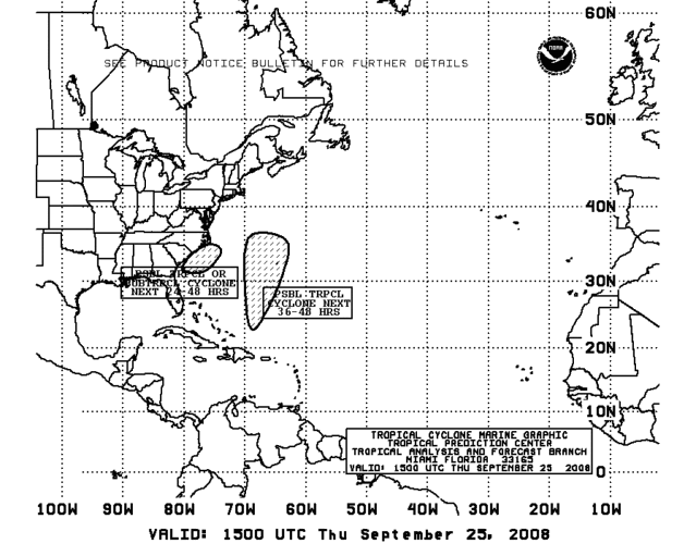
24-48 hours? Likely it doesn't have 12 hours!!
0 likes   

Ed Mahmoud

Re: ATL INVEST 94L: Discussion

#222 Postby Ed Mahmoud » Thu Sep 25, 2008 10:36 am

3º C isn't chicken feed, as far as a temperature differential.


Why bother sending a recon when they won't upgrade to a sub-tropical cyclone no matter what recon finds?
0 likes   

User avatar
Lowpressure
S2K Supporter
S2K Supporter
Posts: 2032
Age: 57
Joined: Sun Sep 14, 2003 9:17 am
Location: Charlotte, North Carolina

Re: ATL INVEST 94L: Discussion

#223 Postby Lowpressure » Thu Sep 25, 2008 10:39 am

Ed Mahmoud wrote:3º C isn't chicken feed, as far as a temperature differential.


Why bother sending a recon when they won't upgrade to a sub-tropical cyclone no matter what recon finds?

Very good point.
0 likes   

Ed Mahmoud

Re: ATL INVEST 94L: Discussion

#224 Postby Ed Mahmoud » Thu Sep 25, 2008 10:41 am

If one looks at the cold air strato-cu South of the system, you can see some evidence of anticyclonic outflow trying to develop above that in the cirrus.

ADD visible loop- updates ~4 times an hour, good resolution


Of course, cold air strato-cu usually isn't a good sign re TC/sub TC development... For that matter, that may just be fog/stratus, if you stare long enough at it. Warm season version of arctic sea smoke.
0 likes   

User avatar
HURAKAN
Professional-Met
Professional-Met
Posts: 46086
Age: 37
Joined: Thu May 20, 2004 4:34 pm
Location: Key West, FL
Contact:

#225 Postby HURAKAN » Thu Sep 25, 2008 11:00 am

0 likes   

Ed Mahmoud

Re: ATL INVEST 94L: Discussion

#226 Postby Ed Mahmoud » Thu Sep 25, 2008 11:05 am

Since nothing they can find will lead to an upgrade in a ~995 mb system with 50 knot winds and a 3ºC differential, they should send AF307 home now, so the crew has time to get back to Keesler, debrief, and have dinner at home with their families at a decent hour.
0 likes   

Ed Mahmoud

Re: ATL: INVEST 94L Recon Discussion

#227 Postby Ed Mahmoud » Thu Sep 25, 2008 11:07 am

Might as well stand down tomorrow's Teal 73 now.

Since nothing they can find will lead to an upgrade in a ~995 mb system with 50 knot winds and a 3ºC differential, they should send AF307 home now, so the crew has time to get back to Keesler, debrief, and have dinner at home with their families at a reasonable hour.
0 likes   

User avatar
HURAKAN
Professional-Met
Professional-Met
Posts: 46086
Age: 37
Joined: Thu May 20, 2004 4:34 pm
Location: Key West, FL
Contact:

#228 Postby HURAKAN » Thu Sep 25, 2008 11:08 am

Image

Image
0 likes   

capepoint
Category 1
Category 1
Posts: 414
Joined: Sat Jul 19, 2008 7:13 pm
Location: Beaufort, NC

#229 Postby capepoint » Thu Sep 25, 2008 11:08 am

000
NOUS42 KMHX 251504
PNSMHX
NCZ029-044>047-079>081-090>095-098-103-104-252300-

PUBLIC INFORMATION STATEMENT
NATIONAL WEATHER SERVICE NEWPORT/MOREHEAD CITY NC
1100 AM EDT THU SEP 25 2008

THE FOLLOWING ARE OFFICIAL OBSERVATIONS TAKEN FROM 09/24/08 AND
09/25/08 FOR THE COASTAL STORM AFFECTING EASTERN NORTH CAROLINA.

*****************************PEAK WIND GUSTS*****************

LOCATION PEAK WIND TIME/DATE
GUST (MPH) OF
MEASUREMENT

NWS NEWPORT 37 726 PM 9/24

--ASOS--

BEAUFORT 47 854 PM 9/24
CAPE HATTERAS 45 403 PM 9/24
NEW BERN 41 433 AM 9/25

*************************************************************

THE FOLLOWING ARE UNOFFICIAL AND PRELIMINARY OBSERVATIONS TAKEN
FROM 9/24/08 AND 9/25/08 FOR THE COASTAL STORM AFFECTING EASTERN
NORTH CAROLINA.

***********************PEAK WIND GUSTS***********************

LOCATION PEAK WIND TIME/DATE COMMENTS
GUST OF
(MPH) MEASUREMENT

NORTH CAROLINA

...CARTERET COUNTY...
CEDAR ISLAND 51 610 AM 9/25 CTI
INDIAN BEACH 51 814 AM 9/25 MESONET
ATLANTIC BEACH 47 703 AM 9/25 MESONET
CEDAR POINT 38 800 AM 9/25 MESONET
SURF CITY 46 430 AM 9/25 MESONET

...ONSLOW COUNTY...
JACKSONVILLE 34 445 PM 9/24 MESONET
NORTH TOPSAIL 34 530 PM 9/24 MESONET

...DARE COUNTY
PEA ISLAND NWR 59 250 AM 9/25 PEI
HATTERAS ISLAND 56 750 PM 9/24 NC FERRY
KILL DEVIL HILLS 40 700 PM 9/24 MESONET
KITTY HAWK 39 258 AM 9/25 FFA
MANTEO 48 321 AM 9/25 MQI
STUMPY POINT 44 550 AM 9/25 SPO

...HYDE COUNTY...
SWANQUARTER 46 1220 AM 9/25 SWQ
OCRACOKE 58 720 PM 9/24 NC FERRY
OCRACOKE 44 645 PM 9/24 MESONET

...TYRRELL...
ALLIGATOR RIVER 50 500 PM 9/24 BRIDGE READING

$$

CULLEN


...This is more than we got from Hannah! Tides along the south and west sides of the Pamlico Sound and lower Neuse river are 4-5 feet above normal, resulting in minor flooding. Ocean overwash has closed NC12 on the OBX, and sound flooding has periodicly closed NC12 in Carteret County.
0 likes   

CrazyC83
Professional-Met
Professional-Met
Posts: 33399
Joined: Tue Mar 07, 2006 11:57 pm
Location: Deep South, for the first time!

#230 Postby CrazyC83 » Thu Sep 25, 2008 11:09 am

That looks separated from the front in my view...
0 likes   

User avatar
Category 5
Category 5
Category 5
Posts: 10074
Age: 34
Joined: Sun Feb 11, 2007 10:00 pm
Location: New Brunswick, NJ
Contact:

Re: ATL INVEST 94L: Discussion

#231 Postby Category 5 » Thu Sep 25, 2008 11:14 am

Ed Mahmoud wrote:3º C isn't chicken feed, as far as a temperature differential.


Why bother sending a recon when they won't upgrade to a sub-tropical cyclone no matter what recon finds?


There must be a reason why they aren't upgrading it. The NHC doesn't discriminate what gets upgraded.
0 likes   

User avatar
Hurricaneman
Category 5
Category 5
Posts: 7285
Age: 43
Joined: Tue Aug 31, 2004 3:24 pm
Location: central florida

Re: ATL INVEST 94L: Discussion

#232 Postby Hurricaneman » Thu Sep 25, 2008 11:16 am

Category 5 wrote:
Ed Mahmoud wrote:3º C isn't chicken feed, as far as a temperature differential.


Why bother sending a recon when they won't upgrade to a sub-tropical cyclone no matter what recon finds?


There must be a reason why they aren't upgrading it. The NHC doesn't discriminate what gets upgraded.


I would have to say the sat pics are the reason, it still looks extratropical to me, not enough t-storms around the center
0 likes   

User avatar
Category 5
Category 5
Category 5
Posts: 10074
Age: 34
Joined: Sun Feb 11, 2007 10:00 pm
Location: New Brunswick, NJ
Contact:

Re: ATL INVEST 94L: Discussion

#233 Postby Category 5 » Thu Sep 25, 2008 11:18 am

A WELL-DEFINED SURFACE LOW PRESSURE SYSTEM CENTERED ABOUT 180 MILES
SOUTHEAST OF THE SOUTH CAROLINA-NORTH CAROLINA BORDER IS MOVING
SLOWLY WESTWARD. SATELLITE IMAGES AND SURFACE OBSERVATIONS INDICATE
THAT THE LOW IS STILL EMBEDDED WITHIN A FRONTAL ZONE AND HAS NOT
YET ACQUIRED TROPICAL CHARACTERISTICS
.
HOWEVER THERE IS STILL A
POSSIBILITY THAT THIS SYSTEM COULD DEVELOP INTO A SUBTROPICAL OR
TROPICAL CYCLONE LATER TODAY. REGARDLESS OF WHETHER OR NOT THIS
OCCURS...STRONG WINDS...COASTAL FLOODING...HIGH SURF...AND
DANGEROUS RIP CURRENTS WILL CONTINUE ALONG PORTIONS OF THE U.S.
EAST COAST DURING THE NEXT COUPLE OF DAYS. INTERESTS ALONG THE U.S.
EAST COAST FROM SOUTH CAROLINA NORTHWARD TO THE MID-ATLANTIC REGION
SHOULD CLOSELY MONITOR STATEMENTS FROM THEIR LOCAL NATIONAL WEATHER
SERVICE FORECAST OFFICES...AND ALSO HIGH SEAS FORECASTS ISSUED BY
THE OCEAN PREDICTION CENTER FOR ADDITIONAL INFORMATION AND
WARNINGS.
0 likes   

CrazyC83
Professional-Met
Professional-Met
Posts: 33399
Joined: Tue Mar 07, 2006 11:57 pm
Location: Deep South, for the first time!

#234 Postby CrazyC83 » Thu Sep 25, 2008 11:20 am

By definition, Extratropical:
A term used in advisories and tropical summaries to indicate that a cyclone has lost its "tropical" characteristics. The term implies both poleward displacement of the cyclone and the conversion of the cyclone's primary energy source from the release of latent heat of condensation to baroclinic (the temperature contrast between warm and cold air masses) processes. It is important to note that cyclones can become extratropical and still retain winds of hurricane or tropical storm force.

Subtropical Cyclone:
A non-frontal low pressure system that has characteristics of both tropical and extratropical cyclones.

The most common type is an upper-level cold low with circulation extending to the surface layer and maximum sustained winds generally occurring at a radius of about 100 miles or more from the center. In comparison to tropical cyclones, such systems have a relatively broad zone of maximum winds that is located farther from the center, and typically have a less symmetric wind field and distribution of convection.

A second type of subtropical cyclone is a mesoscale low originating in or near a frontolyzing zone of horizontal wind shear, with radius of maximum sustained winds generally less than 30 miles. The entire circulation may initially have a diameter of less than 100 miles. These generally short-lived systems may be either cold core or warm core.

Tropical Cyclone:
A warm-core non-frontal synoptic-scale cyclone, originating over tropical or subtropical waters, with organized deep convection and a closed surface wind circulation about a well-defined center. Once formed, a tropical cyclone is maintained by the extraction of heat energy from the ocean at high temperature and heat export at the low temperatures of the upper troposphere. In this they differ from extratropical cyclones, which derive their energy from horizontal temperature contrasts in the atmosphere (baroclinic effects).

http://www.nhc.noaa.gov/aboutgloss.shtml
0 likes   

capepoint
Category 1
Category 1
Posts: 414
Joined: Sat Jul 19, 2008 7:13 pm
Location: Beaufort, NC

#235 Postby capepoint » Thu Sep 25, 2008 11:23 am

Center now appearing on radar (ILM)?

haha local tv met just said election year politics must have spilled over into weather because noaa seems intent on ignoring this storm. He says he does not understand why it has not been named yet. Maybe if they ignore it it will go away. lol
0 likes   

User avatar
Category 5
Category 5
Category 5
Posts: 10074
Age: 34
Joined: Sun Feb 11, 2007 10:00 pm
Location: New Brunswick, NJ
Contact:

Re:

#236 Postby Category 5 » Thu Sep 25, 2008 11:24 am

capepoint wrote:Center now appearing on radar (ILM)?

haha local tv met just said election year politics must have spilled over into weather because noaa seems intent on ignoring this storm. He says he does not understand why it has not been named yet. Maybe if they ignore it it will go away. lol


Perhaps his broadcast met course didn't teach him that frontal lows don't get named. :cheesy: :lol:
0 likes   

Ed Mahmoud

Re: ATL INVEST 94L: Discussion

#237 Postby Ed Mahmoud » Thu Sep 25, 2008 11:37 am

It appears the warm front, from satellite, has now separated from 94L. If you can find me evidence of temperature/dewpoint and wind discontinuities in the recon data that suggests a front near the center, I'd like to see it.
0 likes   

User avatar
HURAKAN
Professional-Met
Professional-Met
Posts: 46086
Age: 37
Joined: Thu May 20, 2004 4:34 pm
Location: Key West, FL
Contact:

#238 Postby HURAKAN » Thu Sep 25, 2008 11:45 am

Image

Time is running out.
0 likes   

User avatar
Blown Away
S2K Supporter
S2K Supporter
Posts: 9876
Joined: Wed May 26, 2004 6:17 am

Re: ATL INVEST 94L: Discussion

#239 Postby Blown Away » Thu Sep 25, 2008 11:46 am

Seems like 94L has picked up forward speed towards the NW, it will be on land pretty soon.
0 likes   

Ed Mahmoud

Re: ATL INVEST 94L: Discussion

#240 Postby Ed Mahmoud » Thu Sep 25, 2008 11:55 am

Blown_away wrote:Seems like 94L has picked up forward speed towards the NW, it will be on land pretty soon.


Well, the coastal flood and wind warnings should prepare the coastal communities/marine interests for this, and it probably saves a lot of typing and coordination calls with local NWS offices to let it landfall as a warm core, non frontal 60 mph un-named extra-tropical storm.

Maybe I read JB too much (every day), and his cynicism is wearing off on me, but I can't see a better reason.

I'm more than open for a pro-met to point out to me the obvious flaw in my reasoning.

I can see why the uncertainty with 93L, with it having an exposed center and poorly defined LLC, when it seems to be heading into even more unfavorable conditions, but not this one.
0 likes   


Return to “2008”

Who is online

Users browsing this forum: No registered users and 9 guests