
ATL INVEST 94L: Discussion
Moderator: S2k Moderators
-
Ed Mahmoud
Re: ATL INVEST 94L: Discussion
If one were motivated, and had the right software, one could plot temp and dewpoint on a grid of lat and long, and could not only try to determine if 94L is acquirng a warm core, but also look for temp/dewpoint/wind discontinuities that would imply frontal boundaries.
Maybe I'll PM a couple of pro-mets.
Ed
Maybe I'll PM a couple of pro-mets.
Ed
0 likes
-
Ed Mahmoud
Re: ATL INVEST 94L: Discussion
Ed Mahmoud wrote:If one were motivated, and had the right software, one could plot temp and dewpoint on a grid of lat and long, and could not only try to determine if 94L is acquirng a warm core, but also look for temp/dewpoint/wind discontinuities that would imply frontal boundaries.
Maybe I'll PM a couple of pro-mets.
Ed
PM sent to WxMan57 and AJC3.
Of course, I'm sure someone at NHC is doing this as we speak, but we'll probably get quicker results, if either/both of the pro-mets PM'd are feeling extra motivated.
0 likes
-
HenkL
- S2K Supporter

- Posts: 2401
- Joined: Fri Sep 10, 2004 5:33 pm
- Location: Groningen, The Netherlands
- Contact:
URNT12 KNHC 251410
VORTEX DATA MESSAGE
A. 25/13:48:10Z
B. 32 deg 13 min N
076 deg 46 min W
C. NA
D. 54 kt
E. 209 deg 31 nm
F. 306 deg 47 kt
G. 214 deg 36 nm
H. EXTRAP 994 mb
I. 20 C / 336 m
J. 23 C / 334 m
K. 21 C / NA
L. NA
M. NA
N. 134 / 1
O. 0.02 / 2 nm
P. AF307 02GGA INVEST OB 12
MAX FL WIND 47 KT SW QUAD 13:33:00Z
SLP EXTRAP FROM BELOW 1500 FT
MAX FL TEMP 23 C 193 / 19 NM FROM FL CNTR
MAX FL WIND IN INVEST 50 KTS SE QUAD 12:56:50Z
0 likes
-
Ed Mahmoud
Re:
HenkL wrote:URNT12 KNHC 251410
VORTEX DATA MESSAGE
A. 25/13:48:10Z
B. 32 deg 13 min N
076 deg 46 min W
C. NA
D. 54 kt
E. 209 deg 31 nm
F. 306 deg 47 kt
G. 214 deg 36 nm
H. EXTRAP 994 mb
I. 20 C / 336 m
J. 23 C / 334 m
K. 21 C / NA
L. NA
M. NA
N. 134 / 1
O. 0.02 / 2 nm
P. AF307 02GGA INVEST OB 12
MAX FL WIND 47 KT SW QUAD 13:33:00Z
SLP EXTRAP FROM BELOW 1500 FT
MAX FL TEMP 23 C 193 / 19 NM FROM FL CNTR
MAX FL WIND IN INVEST 50 KTS SE QUAD 12:56:50Z
That seems to answer whether it has begun to develop a warm core.
I smell STS Kyle in about 40 minutes...
0 likes
-
Ed Mahmoud
Re: ATL INVEST 94L: Discussion
In my amateur opinion, biggest mystery left, with 50 knot recon winds, does NHC just issue a TS warning for the Carolina coast, or also issue a H Watch for the same area.
0 likes


-
HURAKAN

- Professional-Met

- Posts: 46086
- Age: 38
- Joined: Thu May 20, 2004 4:34 pm
- Location: Key West, FL
- Contact:
319
NOUS42 KNHC 251500
WEATHER RECONNAISSANCE FLIGHTS
CARCAH, NATIONAL HURRICANE CENTER, MIAMI, FL.
1100 AM EDT THU 25 SEPTEMBER 2008
SUBJECT: TROPICAL CYCLONE PLAN OF THE DAY (TCPOD)
VALID 26/1100Z TO 27/1100Z SEPTEMBER 2008
TCPOD NUMBER.....08-117
I. ATLANTIC REQUIREMENTS
1.LOW (OFF CAROLINA COAST)
FLIGHT ONE -- TEAL 73
A. 26/1200, 1800Z
B. AFXXX 04GGA LOW
C. 26/0830Z
D. 33.3N 78.7W
E. 26/1100Z TO 26/1800Z
F. SFC TO 10,000 FT
2.SUSPECT AREA (NORTH OF HISPANIOLA)
FLIGHT ONE -- TEAL 72
A. 26/1800Z
B. AFXXX 12FFA CYCLONE
C. 26/1500Z
D. 29.5N 69.5W
E. 26/1700Z TO 26/21030Z
F. SFC TO 10,000 FT
FLIGHT TWO -- TEAL 70
A. 27/0600Z
B. AFXXX 13FFA CYCLONE
C. 27/0200Z
D. 33.5N 69.5W
E. 27/0500Z TO 27/0900Z
F. SFC TO 10,000 FT
3.OUTLOOK FOR SUCCEEDING DAY: NEGATIVE OFF THE CAROLINA'S.
THAT SYSTEM SHOULD BE OVER LAND. CONTINUE 12-HRLY FIXES
ON SYSTEM IN THE WESTERN ATLANTIC IF STILL A THREAT. P-3
RESEARCH MISSIONS EVERY 12 HRS.
4.THE P-3'S HAVE BEEN TASKED FOR RESEARCH MISSIONS TAKING
OFF AT 26/2000Z AND 27/0800Z INTO THESE SYSTEMS.
II. PACIFIC REQUIREMENTS
1. NEGATIVE RECONNAISSANCE REQUIREMENTS.
2. SUCCEEDING DAY OUTLOOK.....NEGATIVE.
JWP
0 likes
-
Lowpressure

- S2K Supporter
- Posts: 2032
- Age: 58
- Joined: Sun Sep 14, 2003 9:17 am
- Location: Charlotte, North Carolina
Re: ATL INVEST 94L: Discussion
Sanibel wrote:Year of the dry air intrusion.
Seems to be attempting to shut the dry air out. Sitting over the Gulf Stream does not hurt either.
0 likes
-
Lowpressure
- S2K Supporter
- Posts: 2032
- Age: 58
- Joined: Sun Sep 14, 2003 9:17 am
- Location: Charlotte, North Carolina
Re:
CrazyC83 wrote:20/23/21 for a temperature profile with 23 in the core suggests a subtropical storm?
Just wondering the same thing looking at the latest VDM.
0 likes
-
Category 5

- Category 5

- Posts: 10074
- Age: 35
- Joined: Sun Feb 11, 2007 10:00 pm
- Location: New Brunswick, NJ
- Contact:
-
HURAKAN
- Professional-Met
- Posts: 46086
- Age: 38
- Joined: Thu May 20, 2004 4:34 pm
- Location: Key West, FL
- Contact:
Andrea:
URNT12 KNHC 101341
VORTEX DATA MESSAGE
A. 10/13:19:50Z
B. 30 deg 02 min N
079 deg 52 min W
C. NA mb NA m
D. 30 kt
E. 48 deg 081 nm
F. 095 deg 032 kt
G. 047 deg 071 nm
H. EXTRAP 1003 mb
I. 22 C/ 303 m
J. 22 C/ 304 m
K. 20 C/ NA
L. NA
M. NA
N. 134 / 1
O. 0.02 / 2 nm
P. AF307 0201A ANDREA OB 08
MAX FL WIND 38 KT NW QUAD 11:05:00 Z
SLP EXTRAP FROM 1500 FT.
94L:
067
URNT12 KNHC 251446 CCA
VORTEX DATA MESSAGE
A. 25/13:48:10Z
B. 32 deg 13 min N
076 deg 46 min W
C. NA
D. 54 kt
E. 209 deg 31 nm
F. 306 deg 47 kt
G. 214 deg 36 nm
H. EXTRAP 994 mb
I. 20 C / 336 m
J. 23 C / 334 m
K. 21 C / NA
L. NA
M. NA
N. 134 / 1
O. 0.02 / 2 nm
P. AF307 02GGA INVEST OB 12 CCA
MAX FL WIND 47 KT SW QUAD 13:33:00Z
SLP EXTRAP FROM BELOW 1500 FT
MAX FL TEMP 23 C 193 / 19 NM FROM FL CNTR
MAX OUTBOUND AND MAX FL WIND 54 KTS NE QUAD 13:54:10 Z
;
0 likes
-
HURAKAN
- Professional-Met
- Posts: 46086
- Age: 38
- Joined: Thu May 20, 2004 4:34 pm
- Location: Key West, FL
- Contact:
Re: ATL INVEST 94L: Discussion
Jeff Masters: http://www.wunderground.com/blog/JeffMa ... amp=200809
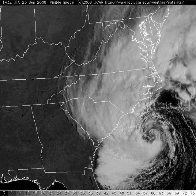
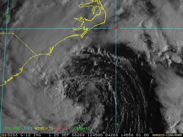
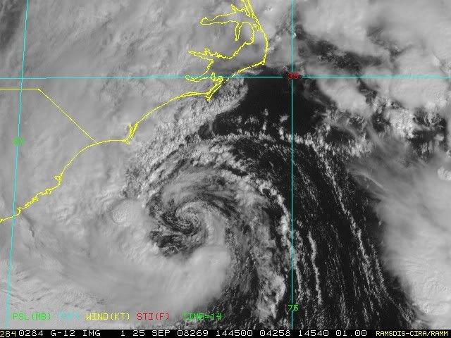
A powerful extratropical storm (94L) with some tropical characteristics is bringing tropical storm-like conditions to the waters just offshore the U.S. coast, from South Carolina to Virginia. QuikSCAT data from this morning and last night (Figure 1) show that tropical storm-force winds of 40-50 mph cover a 400-mile swath of ocean just offshore the North Carolina coast. A Hurricane Hunter mission currently investigating 94L confirms that these winds continue, with a few spots of 55 mph winds. Visible satellite loops show a small amount of heavy thunderstorm activity near the center, with a long curved band of thunderstorms that arcs from the center northeastwards for several hundred miles. This configuration is characteristic of a subtropical or extratropical storm. NHC is currently judging the storm to be more extratropical, so it doesn't get a name. The difference is unimportant as far as the impact on the coast goes, since this storm will bring tropical storm force winds of 40-50 mph to the coast from northern South Carolina to Virginia today through Friday morning as it moves ashore. NHC is currently giving 94L a high (>50% chance) of becoming a subtropical storm by Friday. An Air Force Hurricane Hunter aircraft sent in a center fix at 9:48 am EDT, finding a central pressure of 994 mb and top surface winds of 54 knots (62 mph).
The storm is affecting a wide area of coast from New York to South Carolina. Minor coastal flooding due to high winds is forecast as far north as New York City. The Onslow Bay buoy south of Wilmington, North Carolina, reported 13 foot waves and sustained winds of 45 mph at 8:20 am EDT. Wave heights in excess of 15 feet have been observed from Delaware to South Carolina, with the highest waves of 19 feet measured at the Virginia Beach Buoy 75 miles offshore from the Virginia/North Carolina border. Expect tide levels of 3-6 feet above normal along the coast, and rain amounts of 2-3 inches. Cape Hatteras, NC radar shows an extensive area of rain all along the coast. Thus far, (Figure 2) only 1-2 inches has fallen along the coast, but the heaviest rain has yet to move ashore. Rainfall amounts up to five inches (Figure 3) are likely from 94L as it sloshes northwards along the coast over the weekend.
0 likes
-
wxman57

- Moderator-Pro Met

- Posts: 23165
- Age: 68
- Joined: Sat Jun 21, 2003 8:06 pm
- Location: Houston, TX (southwest)
Re:
HURAKAN wrote:Andrea:
URNT12 KNHC 101341
VORTEX DATA MESSAGE
A. 10/13:19:50Z
B. 30 deg 02 min N
079 deg 52 min W
C. NA mb NA m
D. 30 kt
E. 48 deg 081 nm
F. 095 deg 032 kt
G. 047 deg 071 nm
H. EXTRAP 1003 mb
I. 22 C/ 303 m
J. 22 C/ 304 m
K. 20 C/ NA
L. NA
M. NA
N. 134 / 1
O. 0.02 / 2 nm
P. AF307 0201A ANDREA OB 08
MAX FL WIND 38 KT NW QUAD 11:05:00 Z
SLP EXTRAP FROM 1500 FT.
94L:
067
URNT12 KNHC 251446 CCA
VORTEX DATA MESSAGE
A. 25/13:48:10Z
B. 32 deg 13 min N
076 deg 46 min W
C. NA
D. 54 kt
E. 209 deg 31 nm
F. 306 deg 47 kt
G. 214 deg 36 nm
H. EXTRAP 994 mb
I. 20 C / 336 m
J. 23 C / 334 m
K. 21 C / NA
L. NA
M. NA
N. 134 / 1
O. 0.02 / 2 nm
P. AF307 02GGA INVEST OB 12 CCA
MAX FL WIND 47 KT SW QUAD 13:33:00Z
SLP EXTRAP FROM BELOW 1500 FT
MAX FL TEMP 23 C 193 / 19 NM FROM FL CNTR
MAX OUTBOUND AND MAX FL WIND 54 KTS NE QUAD 13:54:10 Z
;
Yeah, I agree. They should have never named Andrea. And I'll be quite happy if they don't name 94L or 93L. It'll be inland in 10-12 hours. Nothing to be gained by naming it.
0 likes
Who is online
Users browsing this forum: No registered users and 51 guests