BEGIN
NHC
invest_al962008.invest
FSTDA
R
U
040
010
0000
200810052022
NONE
NOTIFY=ATRP
END
INVEST, AL, L, , , , , 96, 2008, DB, O, 2008100418, 9999999999, , , , , , METWATCH, , AL962008
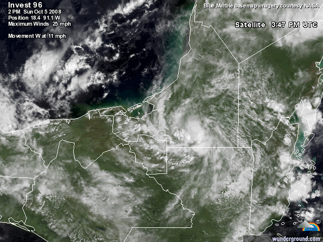
AL, 96, 2008100318, , BEST, 0, 176N, 862W, 20, 1010, DB, 0, , 0, 0, 0, 0,
AL, 96, 2008100400, , BEST, 0, 176N, 865W, 20, 1010, DB, 0, , 0, 0, 0, 0,
AL, 96, 2008100406, , BEST, 0, 176N, 869W, 20, 1010, DB, 0, , 0, 0, 0, 0,
AL, 96, 2008100412, , BEST, 0, 177N, 875W, 20, 1010, DB, 0, , 0, 0, 0, 0,
AL, 96, 2008100418, , BEST, 0, 178N, 880W, 20, 1010, DB, 0, , 0, 0, 0, 0, 1012, 150, 40, 0, 0, L, 0, , 0, 0, INVEST, D,
AL, 96, 2008100500, , BEST, 0, 180N, 886W, 20, 1010, DB, 0, , 0, 0, 0, 0, 1012, 150, 40, 0, 0, L, 0, , 0, 0, INVEST, D,
AL, 96, 2008100506, , BEST, 0, 181N, 893W, 15, 1010, DB, 0, , 0, 0, 0, 0,
AL, 96, 2008100512, , BEST, 0, 182N, 901W, 15, 1010, DB, 0, , 0, 0, 0, 0,
AL, 96, 2008100518, , BEST, 0, 184N, 911W, 20, 1009, DB, 34, NEQ, 0, 0, 0, 0, 1011, 150, 40, 0, 0, L, 0, , 0, 0, INVEST, D,
It's back!
ATL: Marco : Tropical Depression - Discussion
Moderator: S2k Moderators

-
Dean4Storms
- S2K Supporter

- Posts: 6358
- Age: 63
- Joined: Sun Aug 31, 2003 1:01 pm
- Location: Miramar Bch. FL
-
MGC

- S2K Supporter
- Posts: 5940
- Joined: Sun Mar 23, 2003 9:05 pm
- Location: Pass Christian MS, or what is left.
Re: ATL: INVEST 96L - Discussion
Nice little spin....might have a chance once it emerges over the BOC. Convection has increased a bit near the circulation center this afternoon....MGC
0 likes
-
HURAKAN

- Professional-Met

- Posts: 46084
- Age: 39
- Joined: Thu May 20, 2004 4:34 pm
- Location: Key West, FL
- Contact:
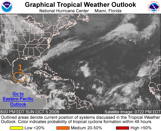
TROPICAL WEATHER OUTLOOK
NWS TPC/NATIONAL HURRICANE CENTER MIAMI FL
800 PM EDT SUN OCT 5 2008
FOR THE NORTH ATLANTIC...CARIBBEAN SEA AND THE GULF OF MEXICO...
A SMALL BUT WELL-DEFINED LOW PRESSURE SYSTEM LOCATED ALONG THE
EXTREME SOUTHWESTERN COAST OF THE YUCATAN PENINSULA IS MOVING
WEST-NORTHWESTWARD AT 10 MPH. THUNDERSTORM ACTIVITY HAS INCREASED
AND BECOME MORE CONCENTRATED NEAR THE CENTER OF CIRCULATION
TODAY...AND IF THIS TREND CONTINUES AS THE SYSTEM MOVES OVER THE
SOUTHERN BAY OF CAMPECHE LATER TONIGHT AND MONDAY...THEN SOME
ADDITIONAL ORGANIZATION COULD OCCUR.
ELSEWHERE...TROPICAL CYCLONE FORMATION IS NOT EXPECTED DURING THE
NEXT 48 HOURS.
$$
FORECASTER STEWART
0 likes


Re: ATL: INVEST 96L - Discussion
Conditions at Oct 05, 2008 - 06:45 PM EDT Carmen 18-39N 091-48W
http://weather.noaa.gov/weather/current/MMCE.html
29.77mb and low should pass very near to here on it's way to BOC
down to 29.75 and 23mph N now.
http://weather.noaa.gov/weather/current/MMCE.html
29.77mb and low should pass very near to here on it's way to BOC
down to 29.75 and 23mph N now.
0 likes
-
captain east

- Tropical Storm

- Posts: 213
- Joined: Thu Aug 28, 2008 2:53 pm
- Location: South East Florida
-
cycloneye

- Admin

- Posts: 149275
- Age: 69
- Joined: Thu Oct 10, 2002 10:54 am
- Location: San Juan, Puerto Rico
Re: ATL: INVEST 96L - Discussion
00:00 UTC Best Track:
AL, 96, 2008100600, , BEST, 0, 185N, 917W, 25, 1007, DB,
AL, 96, 2008100600, , BEST, 0, 185N, 917W, 25, 1007, DB,
0 likes

Re: ATL: INVEST 96L - Discussion
This thing is bell ringing again. Keep in mind this excellently formed burst is over land! I was wrong, it was another prolonged d-min like many other storms this year. The track will be lucky to get this back over water in the very southern BOC. Where it goes from there I'll leave up to GFS. Maybe #13 here.
0 likes
-
wxman57

- Moderator-Pro Met

- Posts: 23172
- Age: 68
- Joined: Sat Jun 21, 2003 8:06 pm
- Location: Houston, TX (southwest)
Re: ATL: INVEST 96L - Discussion
Surface obs over southern MX indicate a well-defined LLC surrounded by deep convection. I think NHC will call this a depression tomorrow if it looks the same out over the BoC. Track is straightforward - WNW across the BoC and into Mexico, possibly near Tuxpan (between 21N-22N), perhaps a bit south of there.
0 likes

-
Ed Mahmoud
Re: ATL: INVEST 96L - Discussion
I wonder if the remnant moisture from this will be pulled up into Texas to meet Tuesday's cold front and enhance our rain chances. Been awfully dry the last 3 weeks in HOU area. I suspect the front will be through the HOU area before the associated moisture can make it up here, but I'm a glass half full kind of optimist.
0 likes
-
Derek Ortt
Re: ATL: INVEST 96L - Discussion
Rule of thumb:
Always beware of storms that burst and strengthen while over land.
Always beware of storms that burst and strengthen while over land.
0 likes
Who is online
Users browsing this forum: No registered users and 38 guests