WPAC: Ex-TY Fengshen 0806 (07W) 1,300 dead

Moderator: S2k Moderators

Message
Author
User avatar
HURAKAN
Professional-Met
Professional-Met
Posts: 46086
Age: 37
Joined: Thu May 20, 2004 4:34 pm
Location: Key West, FL
Contact:

#21 Postby HURAKAN » Mon Jun 16, 2008 6:18 pm

Image

Looking pretty good.
0 likes   

User avatar
KWT
Category 5
Category 5
Posts: 31391
Joined: Tue Aug 17, 2004 11:02 am
Location: UK!!!

#22 Postby KWT » Tue Jun 17, 2008 4:45 am

Looks pretty decent right now with some deep convection. Still needs a little more organisation but I don't think its all that far from being a tropical depression.
0 likes   

User avatar
wyq614
Category 3
Category 3
Posts: 827
Age: 36
Joined: Sun Dec 02, 2007 12:32 am
Location: Beijing, China (Hometown: Qingdao, China, 36.06N 120.43E)
Contact:

#23 Postby wyq614 » Tue Jun 17, 2008 12:26 pm

Oh yeah


the area of convection previously located near 6.6n
133.3e is now located near 8.1n 134.8e, approximately 50 nm
north-northeast of Palau. Recent animated satellite imagery and
a 171327z trmm image show increasingly persistent deep convection
developing around an elongated low level circulation center (LLCC).
Scatterometry observations confirm the LLCC and depict unflagged
15 to 20 knot westerly winds equatorward of the LLCC. The distur-
bance lies in an area of low vertical wind shear under a region
of moderate diffluence associated with the upper level near-
equatorial ridge. Maximum sustained surface winds are estimated
at 13 to 18 knots. Minimum sea level pressure is estimated to be
near 1007 mb. Due to the further consolidation of the LLCC, more
persistent convection and substantial westerly winds equatorward
of the LLCC, the potential for the development of a significant
tropical cyclone within the next 24 hours is upgraded to fair.
0 likes   

User avatar
HURAKAN
Professional-Met
Professional-Met
Posts: 46086
Age: 37
Joined: Thu May 20, 2004 4:34 pm
Location: Key West, FL
Contact:

#24 Postby HURAKAN » Tue Jun 17, 2008 3:16 pm

Image

Image
0 likes   

User avatar
P.K.
Professional-Met
Professional-Met
Posts: 5149
Joined: Thu Sep 23, 2004 5:57 pm
Location: Watford, England
Contact:

Re: WPAC East of Philippines: 94W Invest

#25 Postby P.K. » Tue Jun 17, 2008 3:35 pm

WWJP25 RJTD 171800
WARNING AND SUMMARY 171800.
WARNING VALID 181800.
WARNING IS UPDATED EVERY 6 HOURS.
GALE WARNING.
DEVELOPING LOW 1002 HPA
AT 37N 123E YELLOW SEA MOVING EASTNORTHEAST SLOWLY.
EXPECTED WINDS 30 TO 35 KNOTS WITHIN 300 MILES OF LOW
FOR NEXT 12 HOURS.
WARNING.
DENSE FOG OBSERVED LOCALLY OVER SEA OF OKHOTSK NORTHERN PART OF SEA
OF JAPAN MIDDLE OF SEA OF JAPAN BOHAI YELLOW SEA EAST CHINA SEA.
WARNING.
DENSE FOG OBSERVED LOCALLY OVER WATERS BOUNDED BY 41N 143E 53N 160E
60N 167E 60N 180E 38N 180E 38N 170E 41N 150E 39N 142E 41N 143E.
SUMMARY.
LOW 1002 HPA AT 32N 121E NE 20 KT.
LOW 1010 HPA AT 34N 155E ENE 20 KT.
LOW 1008 HPA AT 55N 159E SSE 10 KT.
LOW 1008 HPA AT 55N 169E EAST 10 KT.
TROPICAL DEPRESSION 1006 HPA AT 09N 135E NW SLOWLY.
HIGH 1020 HPA AT 38N 143E SSE 15 KT.
HIGH 1020 HPA AT 43N 153E ESE 10 KT.
OCCLUDED FRONT FROM 34N 155E TO 35N 156E 36N 157E.
WARM FRONT FROM 36N 157E TO 37N 160E 37N 164E.
COLD FRONT FROM 36N 157E TO 31N 155E 28N 148E.
STATIONARY FRONT FROM 22N 111E TO 26N 116E 32N 121E 33N 130E.

JAPAN METEOROLOGICAL AGENCY.=
0 likes   

User avatar
senorpepr
Military Met/Moderator
Posts: 12542
Age: 41
Joined: Fri Aug 22, 2003 9:22 pm
Location: Mackenbach, Germany
Contact:

Re: WPAC: Tropical Depression (94W) - E of Philippines

#26 Postby senorpepr » Tue Jun 17, 2008 4:04 pm

0 likes   

User avatar
KWT
Category 5
Category 5
Posts: 31391
Joined: Tue Aug 17, 2004 11:02 am
Location: UK!!!

#27 Postby KWT » Tue Jun 17, 2008 4:45 pm

Yep it does look like a gtropical depression now, wouldn't be surprised given its structure if it got going fairly quickly as well once it become established.

so the WPAC carries on the quick pace.
0 likes   

User avatar
senorpepr
Military Met/Moderator
Posts: 12542
Age: 41
Joined: Fri Aug 22, 2003 9:22 pm
Location: Mackenbach, Germany
Contact:

Re: WPAC: Tropical Depression (94W) - E of Philippines

#28 Postby senorpepr » Tue Jun 17, 2008 5:27 pm

22Z observations... (with 21Z synoptic)


Image


Looks like a circulation going north of Palau. No north wind observations, but then again, there are no observations where a north wind would be found.
0 likes   

User avatar
cycloneye
Admin
Admin
Posts: 139593
Age: 67
Joined: Thu Oct 10, 2002 10:54 am
Location: San Juan, Puerto Rico

Re: WPAC: Tropical Depression (94W) - E of Philippines

#29 Postby cycloneye » Tue Jun 17, 2008 6:04 pm

ABPW10 PGTW 172300
MSGID/GENADMIN/NAVMARFCSTCEN PEARL HARBOR HI/JTWC//
SUBJ/SIGNIFICANT TROPICAL WEATHER ADVISORY FOR THE WESTERN AND
/SOUTH PACIFIC OCEANS REISSUED/172300Z-180600ZJUN2008//
RMKS/
1. WESTERN NORTH PACIFIC AREA (180 TO MALAY PENINSULA):
A. TROPICAL CYCLONE SUMMARY: NONE.
B. TROPICAL DISTURBANCE SUMMARY:
(1) THE AREA OF CONVECTION PREVIOUSLY LOCATED NEAR 8.1N
134.8E IS NOW LOCATED NEAR 8.2N 134.3E, APPROXIMATELY 60 NM
NORTH-NORTHWEST OF PALAU. RECENT ANIMATED INFRARED SATELLITE
IMAGERY AND A 171723Z AMSU-B MICROWAVE IMAGE SHOW CONTINUED
CONSOLIDATION OF DEEP CONVECTIVE BANDING AROUND A BROAD LOW
LEVEL CIRCULATION CENTER (LLCC). AT 171200Z, ASCAT OBSERVA-
TIONS CONFIRM THE LLCC AND DEPICT UNFLAGGED 15 TO 20 KNOT WINDS
WRAPPING INTO THE CENTER. THE DISTURBANCE LIES IN AN AREA OF LOW
VERTICAL WIND SHEAR UNDER A REGION OF MODERATE DIFFLUENCE ASSO-
CIATED WITH THE UPPER LEVEL NEAR-EQUATORIAL RIDGE. ADDITIONALLY,
RECENT ANIMATED WATER VAPOR IMAGERY INDICATES AN IMPROVING POLE-
WARD OUTFLOW CHANNEL ASSOCIATED WITH A TROPICAL UPPER TROPO-
SPHERIC TROUGH (TUTT) CELL TO THE NORTHEAST. POSITION CONFIDENCE
IS LOW DUE TO THE ELONGATED NATURE OF THE LLCC; HOWEVER, SCATTER-
OMETRY DATA, MICROWAVE IMAGERY AND WEST-NORTHWESTERLY WINDS REPORT-
ED AT PALAU ARE CONSISTENT WITH THE POSITIONING OF THE LLCC NORTH-
WEST OF KOROR. MAXIMUM SUSTAINED SURFACE WINDS ARE ESTIMATED AT 17
TO 22 KNOTS. MINIMUM SEA LEVEL PRESSURE IS ESTIMATED TO BE NEAR
1007 MB. DUE TO THE IMPROVED (BUT SLOW) CONSOLIDATION AND INCREAS-
INGLY FAVORABLE UPPER LEVEL ENVIRONMENT, THE AREA IS UPGRADED TO
GOOD.
0 likes   

User avatar
KWT
Category 5
Category 5
Posts: 31391
Joined: Tue Aug 17, 2004 11:02 am
Location: UK!!!

#30 Postby KWT » Tue Jun 17, 2008 6:26 pm

so looks like the system has got a little stronger cycloneye, at least it looks that way at the moment, convection trying to wrap up around the center it seems.
0 likes   

User avatar
HURAKAN
Professional-Met
Professional-Met
Posts: 46086
Age: 37
Joined: Thu May 20, 2004 4:34 pm
Location: Key West, FL
Contact:

#31 Postby HURAKAN » Tue Jun 17, 2008 7:11 pm

Image

Looking great.
0 likes   

User avatar
HURAKAN
Professional-Met
Professional-Met
Posts: 46086
Age: 37
Joined: Thu May 20, 2004 4:34 pm
Location: Key West, FL
Contact:

#32 Postby HURAKAN » Tue Jun 17, 2008 7:11 pm

Image
0 likes   

HurricaneRobert
Category 3
Category 3
Posts: 812
Joined: Fri May 18, 2007 9:31 pm

Re: WPAC: Tropical Depression (94W) - E of Philippines - TCFA

#33 Postby HurricaneRobert » Tue Jun 17, 2008 7:20 pm

Another fishy?
0 likes   

Typhoon Hunter
WesternPacificWeather.com
Posts: 1215
Age: 40
Joined: Wed Oct 11, 2006 11:37 am
Location: Hong Kong
Contact:

Re: WPAC: Tropical Depression (94W) - E of Philippines - TCFA

#34 Postby Typhoon Hunter » Tue Jun 17, 2008 8:29 pm

ECMWF develops this quite aggresively taking it off to the NE where it develops into a potent system before eventually impacting Japan way off at T+240hrs. The tropics are awakening from their recent slumber.
0 likes   

User avatar
HURAKAN
Professional-Met
Professional-Met
Posts: 46086
Age: 37
Joined: Thu May 20, 2004 4:34 pm
Location: Key West, FL
Contact:

#35 Postby HURAKAN » Tue Jun 17, 2008 9:57 pm

17/2030 UTC 8.2N 133.6E T1.5/1.5 94W -- West Pacific Ocean
0 likes   

User avatar
KWT
Category 5
Category 5
Posts: 31391
Joined: Tue Aug 17, 2004 11:02 am
Location: UK!!!

#36 Postby KWT » Wed Jun 18, 2008 4:59 am

Yep this system is looking better and better however the convection still needs to get a little more consolidated before it gets to tropical storm status I think and thats likely reflected in the sat.estimates of 1.5.
0 likes   

Typhoon Hunter
WesternPacificWeather.com
Posts: 1215
Age: 40
Joined: Wed Oct 11, 2006 11:37 am
Location: Hong Kong
Contact:

Re: WPAC: Tropical Depression (94W) - E of Philippines - TCFA

#37 Postby Typhoon Hunter » Wed Jun 18, 2008 7:22 am

It was looking quite elongated earlier but no doubt it will get its act together soon.

Most of the models still take this north and then north east so hopefully it will spare the Philippines any trouble.
0 likes   

User avatar
senorpepr
Military Met/Moderator
Posts: 12542
Age: 41
Joined: Fri Aug 22, 2003 9:22 pm
Location: Mackenbach, Germany
Contact:

Re: WPAC: Trop. Depression (RP-Frank, JTWC 07W) - E of Philippin

#38 Postby senorpepr » Wed Jun 18, 2008 8:17 am

WWJP25 RJTD 180600
WARNING AND SUMMARY 180600.
WARNING VALID 190600.
WARNING IS UPDATED EVERY 6 HOURS.
GALE WARNING.
DEVELOPING LOW 1000 HPA
AT 39N 125E YELLOW SEA MOVING EASTNORTHEAST 15 KNOTS.
WINDS 30 TO 35 KNOTS WITHIN 300 MILES OF LOW.
WARNING.
DENSE FOG OBSERVED LOCALLY OVER SEA OF OKHOTSK NORTHERN PART OF SEA
OF JAPAN MIDDLE OF SEA OF JAPAN YELLOW SEA.
WARNING.
DENSE FOG OBSERVED LOCALLY OVER WATERS BOUNDED BY 42N 142E 47N 152E
55N 162E 60N 164E 60N 180E 39N 180E 35N 170E 35N 160E 40N 160E 39N
147E 42N 142E.
SUMMARY.
LOW 1012 HPA AT 37N 161E NE 15 KT.
TROPICAL DEPRESSION 1006 HPA AT 09N 133E WEST SLOWLY.
HIGH 1018 HPA AT 37N 145E EAST 10 KT.
STATIONARY FRONT FROM 21N 106E TO 23N 112E 27N 118E 30N 123E 34N 127E
35N 132E.
STATIONARY FRONT FROM 31N 155E TO 34N 158E 37N 161E 40N 164E 41N
169E.
JAPAN METEOROLOGICAL AGENCY.=


Severe Weather Bulletin Number ONE
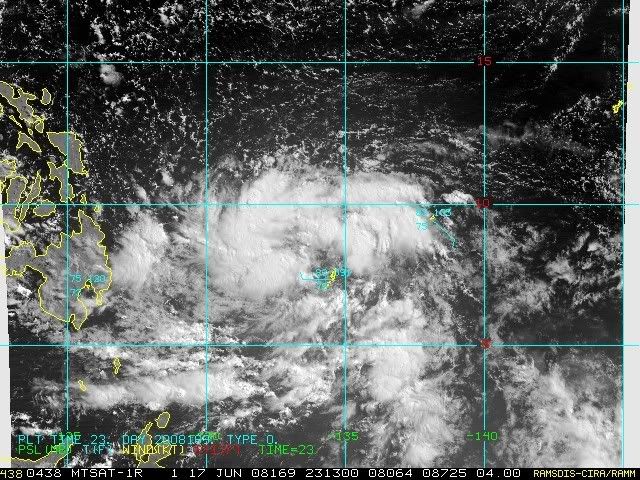
Tropical Cyclone Alert: Tropical Depression "FRANK"
Issued at 5:00 p.m., Wednesday, 18 June 2008 The active low pressure area east of Northern Mindanao has developed into a tropical depression and was named "FRANK".
Location of Center:
(as of 4:00 p.m.) 670 kms East Northeast of Hinatuan Surigao del Sur
Coordinates: 9.1°N, 132.8°E
Strength: Maximum sustained winds of 55 kph near the center
Movement: West Northwest at 15 kph
Forecast Positions/Outlook:
Thursday afternoon: 490 kms East of Surigao City
Friday afternoon: 350 kms east of Catarman, Northern Samar
Saturday afternoon: 510 kms east of Baler, Aurora

No Public Storm Warning Signals Raised

Tropical Depression "Frank" still far to affect any part of the country.

The public and the disaster coordinating councils concerned are advised to be alert for any development and watch for the next bulletin to be issued at 11 p.m. today


JTWC hasn't issued their bulletin, but NRL has upgraded to 07W.


Image
0 likes   

User avatar
Chacor
Category 5
Category 5
Posts: 10229
Joined: Mon Oct 02, 2006 10:43 pm
Location: Singapore

#39 Postby Chacor » Wed Jun 18, 2008 8:37 am

WTPQ20 RJTD 181200
RSMC TROPICAL CYCLONE ADVISORY
NAME TD
ANALYSIS
PSTN 181200UTC 09.3N 132.5E POOR
MOVE W SLOWLY
PRES 1006HPA
MXWD 030KT
GUST 045KT
FORECAST
24HF 191200UTC 11.5N 130.5E 120NM 70%
MOVE NW 08KT
PRES 1000HPA
MXWD 035KT
GUST 050KT =
0 likes   

User avatar
KWT
Category 5
Category 5
Posts: 31391
Joined: Tue Aug 17, 2004 11:02 am
Location: UK!!!

#40 Postby KWT » Wed Jun 18, 2008 8:47 am

Hmmm so forecasted to be a tropical storm in 24hrs tidme, it wouldn't surprised given whilst it does look a little elongated its got what looks to be a fairly healthy structure to it.
0 likes   


Return to “2008”

Who is online

Users browsing this forum: No registered users and 10 guests