TC Bertha
Moderator: S2k Moderators
-
Ivanhater

- Storm2k Moderator

- Posts: 11222
- Age: 39
- Joined: Fri Jul 01, 2005 8:25 am
- Location: Pensacola
Re: INVEST 92L in the Eastern Atlantic
Ive been taking the wait and see approach with this one, and I think chances are good. We dont have a big blob that moved off the coast and fizzle when it hit the water, we have storms firing on there own (good convergence). So it is able to sustain itself on its own, not just 1 complex thunderstorm that dies off when it hits the water. As well with the outstanding model support, this has a great shot IMHO.
0 likes


-
Aric Dunn
- Category 5

- Posts: 21238
- Age: 43
- Joined: Sun Sep 19, 2004 9:58 pm
- Location: Ready for the Chase.
- Contact:
Re: INVEST 92L in the Eastern Atlantic
here is a animation for everyone.. nice burst of convection starting..
0 likes


-
wxman57

- Moderator-Pro Met

- Posts: 23177
- Age: 68
- Joined: Sat Jun 21, 2003 8:06 pm
- Location: Houston, TX (southwest)
Re: INVEST 92L in the Eastern Atlantic
Ivanhater wrote:Ive been taking the wait and see approach with this one, and I think chances are good. We dont have a big blob that moved off the coast and fizzle when it hit the water, we have storms firing on there own (good convergence). So it is able to sustain itself on its own, not just 1 complex thunderstorm that dies off when it hits the water. As well with the outstanding model support, this has a great shot IMHO.
It does concern me that convection has flared up a bit the past 2-3 hours, but the key is if that convection can increase and persist through tomorrow. As for the model projections (DSHP) of intensity, when have they not forecast development? Most invests never develop, yet the intensity models forecast development on almost every run.
Regardless, I'm quite confident this system will be no more than an irritant in that we'll only have to issue advisories for a storm well out to sea. The 00Z position is already at 12N/19W. I don't know of any storm that's reached the Caribbean from that far north at 19W. And there should be several opportunities for it to turn safely out to sea and not be a threat to the eastern U.S. (regardless of one famous met's somewhat wishful thinking) in the next week or two. He must not have to work the 4th if it develops.
What I don't want to see is another storm like Alberto of 2000 that just doesn't know when to give up and die.
0 likes
-
Aric Dunn
- Category 5
- Posts: 21238
- Age: 43
- Joined: Sun Sep 19, 2004 9:58 pm
- Location: Ready for the Chase.
- Contact:
Re: INVEST 92L in the Eastern Atlantic
ok this should work now

decent flare up .. lets if it persists
decent flare up .. lets if it persists
0 likes
-
Ivanhater
- Storm2k Moderator
- Posts: 11222
- Age: 39
- Joined: Fri Jul 01, 2005 8:25 am
- Location: Pensacola
Re: INVEST 92L in the Eastern Atlantic
wxman57 wrote:Ivanhater wrote:Ive been taking the wait and see approach with this one, and I think chances are good. We dont have a big blob that moved off the coast and fizzle when it hit the water, we have storms firing on there own (good convergence). So it is able to sustain itself on its own, not just 1 complex thunderstorm that dies off when it hits the water. As well with the outstanding model support, this has a great shot IMHO.
It does concern me that convection has flared up a bit the past 2-3 hours, but the key is if that convection can increase and persist through tomorrow. As for the model projections (DSHP) of intensity, when have they not forecast development? Most invests never develop, yet the intensity models forecast development on almost every run.
Regardless, I'm quite confident this system will be no more than an irritant in that we'll only have to issue advisories for a storm well out to sea. The 00Z position is already at 12N/19W. I don't know of any storm that's reached the Caribbean from that far north at 19W. And there should be several opportunities for it to turn safely out to sea and not be a threat to the eastern U.S. (regardless of one famous met's somewhat wishful thinking) in the next week or two. He must not have to work the 4th if it develops.
What I don't want to see is another storm like Alberto of 2000 that just doesn't know when to give up and die.
Haaa..very true Wxman. I remember the last time I was tracking around the 4th..Dennis 05..but yeah, it has passed the 1st phase imo of being able to sustain itself without 1 huge thunderstorm complex that looks great but dies as soon as it hits the water. As you say will it be able to keep it up? As far as the ships, I honestly havnt looked at them much, brings it to a cat 2 I believe, but the globals seem to like the development chances, at least in the near term.
Track wise, looks like there will be a weakness, but the ridge might build back in later on, depending on what global model you look at. Regardless, wouldnt that be something to have a cape verde storm the start of July? Those warmer waters off Africa has something to do with that I would imagine.
Last edited by Ivanhater on Tue Jul 01, 2008 8:09 pm, edited 2 times in total.
0 likes
-
cycloneye

- Admin

- Posts: 149829
- Age: 69
- Joined: Thu Oct 10, 2002 10:54 am
- Location: San Juan, Puerto Rico
Re: INVEST 92L in the Eastern Atlantic
0 likes

Re: INVEST 92L in the Eastern Atlantic
This image is updated every 15 minutes and has a nice animation
http://oiswww.eumetsat.org/SDDI/cgi/lis ... v=400,pp=0
http://oiswww.eumetsat.org/SDDI/cgi/lis ... v=400,pp=0
0 likes
-
Aric Dunn
- Category 5
- Posts: 21238
- Age: 43
- Joined: Sun Sep 19, 2004 9:58 pm
- Location: Ready for the Chase.
- Contact:
Re: INVEST 92L in the Eastern Atlantic
8 images is all i can do or the image gets to small since i can only host a certain size file...
this is a animation with a new image from the last on and a little faster..

but its better than the alternative.. i.e no real floater yet
this is a animation with a new image from the last on and a little faster..
but its better than the alternative.. i.e no real floater yet
0 likes
-
brunota2003

- S2K Supporter

- Posts: 9476
- Age: 35
- Joined: Sat Jul 30, 2005 9:56 pm
- Location: Stanton, KY...formerly Havelock, NC
- Contact:
Re: Re:
Eyewall wrote:jabber wrote:Eyewall wrote:code orange now
Ohhh... thank you great one..... boy them were the days.
i dont get it :|
Maybe about the air quality Code Orange? I dunno
0 likes
-
SouthFloridawx

- S2K Supporter
- Posts: 8346
- Age: 47
- Joined: Tue Jul 26, 2005 1:16 am
- Location: Sarasota, FL
- Contact:
Re: INVEST 92L in the Eastern Atlantic
Hey Aric... I think you're right man. Looks like we may have something in the morning, as long as this convection keeps up.
Especially with the upper level support and low level convergence. I'd be betting on at least a TD within 48 Hours.

Especially with the upper level support and low level convergence. I'd be betting on at least a TD within 48 Hours.
0 likes

Re: Re:
Eyewall wrote:jabber wrote:Eyewall wrote:code orange now
Ohhh... thank you great one..... boy them were the days.
i dont get it :|
IIRC there was a user named The Great One long ago who acted ridiculously.
0 likes
-
Gustywind

- Category 5
- Posts: 12334
- Joined: Mon Sep 03, 2007 7:29 am
- Location: Baie-Mahault, GUADELOUPE
Re: INVEST 92L in the Eastern Atlantic
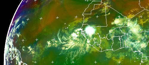
cycloneye wrote::uarrow: And look also at the big bombing of convection behind 92L.
Yeah good looking Cycloneye, waouw a big baby is on fire; amazing

0 likes
-
MiamiensisWx
Re: INVEST 92L in the Eastern Atlantic
I have rescinded my previous decision and I will resume posting here. I still don't believe it will develop (per my latest analysis), but the challenges of forecasting are manifesting themselves in this situation.
Last edited by MiamiensisWx on Tue Jul 01, 2008 8:38 pm, edited 1 time in total.
0 likes
Who is online
Users browsing this forum: No registered users and 40 guests