Tropical Storm Fay Model Runs

Moderator: S2k Moderators

Message
Author
User avatar
Blown Away
S2K Supporter
S2K Supporter
Posts: 10148
Joined: Wed May 26, 2004 6:17 am

Re: ATL: Tropical Storm Fay Model Runs

#1741 Postby Blown Away » Sat Aug 16, 2008 12:57 am

Bocadude85 wrote:Its all going to depend on where this turn happens could be the difference between south florida or big bend...


If that NW turn begins around 75W instead of 78W it will shoot up the Gulfstream.
0 likes   

User avatar
twister
Tropical Low
Tropical Low
Posts: 37
Joined: Sun Aug 10, 2008 6:03 pm
Location: Suburbs of New Orleans

Re: ATL: Tropical Storm Fay Model Runs

#1742 Postby twister » Sat Aug 16, 2008 1:11 am

The cone trending more westward with each model run. I live in SELA becoming concerned with this trend.
0 likes   

GreenSky
Tropical Storm
Tropical Storm
Posts: 109
Joined: Mon Aug 11, 2008 8:34 pm
Location: Land of Alex Jones!-Austin,TX

Re: ATL: Tropical Storm Fay Model Runs

#1743 Postby GreenSky » Sat Aug 16, 2008 1:16 am

twister wrote:The cone trending more westward with each model run. I live in SELA becoming concerned with this trend.


Well according to Derek Orrt, an expert meteorologist on the tropical analysis forum, "GFS ensembles are indicating that the track may be farther west than expected. very little chance of west of the FL/Alabama line"
0 likes   

User avatar
Steve
S2K Supporter
S2K Supporter
Posts: 9621
Joined: Sat Apr 05, 2003 11:41 pm
Location: Not a state-caster

#1744 Postby Steve » Sat Aug 16, 2008 1:19 am

>>The cone trending more westward with each model run. I live in SELA becoming concerned with this trend.

You should always be concerned, but I wouldn't overblow that threat yet. Use it as an opportunity to check on your stuff and make sure you have what you need. It never hurts to top off your gas tank or to have gallon jugs or a few 24 packs of water on hand, working flashlight & radio (with ample spare batteries) and all the usual things you would need for the heart of the hurricane season anyway (since we're still 3 and a half weeks away from the statistical peak). I recommend you just stay tuned and check in from time to time. I think the models are speaking pretty clearly toward a Florida threat, but give it a look tomorrow evening and Sunday morning. Should things change and you decide you need to act, that should still give you ample time to cover all your bases.

Steve
0 likes   

Ed Mahmoud

Re: ATL: Tropical Storm Fay Model Runs

#1745 Postby Ed Mahmoud » Sat Aug 16, 2008 1:32 am

Canadian does not reform center to SW of Haiti-DR border, like I think is very possible (but not certain), but check it out in 72 hours!


Image


Yes, it is the Canadian, ie the Crazy Uncle Model.
0 likes   

jinftl
Category 5
Category 5
Posts: 4312
Joined: Tue Aug 31, 2004 4:47 pm
Location: fort lauderdale, fl

Re: ATL: Tropical Storm Fay Model Runs

#1746 Postby jinftl » Sat Aug 16, 2008 1:43 am

is this a slight east shift/end of trend west...or just more agreement and less outliers with the different model runs?

these scenarios would probably still bring tropical storm conditions to all of south florida.

Blown_away wrote:
SouthFloridawx wrote:Image


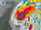
Remarkable 5 day cluster of models, don't think that cluster will push the NHC track W at 5am. SFL is not out of the woods for sure.
0 likes   

User avatar
SouthFloridawx
S2K Supporter
S2K Supporter
Posts: 8346
Age: 46
Joined: Tue Jul 26, 2005 1:16 am
Location: Sarasota, FL
Contact:

Re: ATL: Tropical Storm Fay Model Runs

#1747 Postby SouthFloridawx » Sat Aug 16, 2008 1:46 am

The models shifted more in agreement with the NHC, lol.
0 likes   

jinftl
Category 5
Category 5
Posts: 4312
Joined: Tue Aug 31, 2004 4:47 pm
Location: fort lauderdale, fl

Re: ATL: Tropical Storm Fay Model Runs

#1748 Postby jinftl » Sat Aug 16, 2008 1:49 am

based on these model runs being the latest...i wouldn't expect much change in forecast track at 5am unless some new info comes to light before then

SouthFloridawx wrote:The models shifted more in agreement with the NHC, lol.
0 likes   


User avatar
KWT
Category 5
Category 5
Posts: 31415
Joined: Tue Aug 17, 2004 11:02 am
Location: UK!!!

#1750 Postby KWT » Sat Aug 16, 2008 3:22 am

Models now in pretty good agreement on a gradual turn towards Florida. The eCM is probably now something of a outlier and I can't see it being right however the other models all looking pretty good, if it gets strong enough before Cuba then the biggest threat does appear to be S.Florida.

Just have to see what happens I suppose, got a sneaky feeling the models still haven't quite finished shifting yet.
0 likes   

User avatar
LaBreeze
Category 5
Category 5
Posts: 1497
Joined: Thu Sep 04, 2003 1:57 pm
Location: SW Louisiana

Re: ATL: Tropical Storm Fay Model Runs

#1751 Postby LaBreeze » Sat Aug 16, 2008 3:27 am

Unfortunately for FL, I think this is Florida's baby. Best wishes to you all in FL.- stay safe.
0 likes   

User avatar
ronjon
Category 5
Category 5
Posts: 4822
Joined: Fri Aug 19, 2005 5:17 pm
Location: Hernando Beach, FL

Re: ATL: Tropical Storm Fay Model Runs

#1752 Postby ronjon » Sat Aug 16, 2008 4:29 am

I noticed the 06Z runs of the BAMs shifted west into the eastern GOM - don't know if that is the beginning of a trend or just models swinging back and forth. Yesterday, it was the BAM suite that led the way on the westward shift. God, I hope this thing either goes 150 miles+ west in the Gulf or better yet - inland before it gets to my latitude. For us residents of FL west coast, Fay is a painful reminder of Charley - the storm that hit 4 years and 3 days ago.

https://my.sfwmd.gov/portal/page?_pageid=2854,19644915,2854_19644936:2854_19645022:2854_19645029&_dad=portal&_schema=PORTAL
0 likes   

Toyota Thundra
Tropical Low
Tropical Low
Posts: 33
Joined: Sat Aug 16, 2008 1:35 am
Location: Riverview FL

Re: ATL: Tropical Storm Fay Model Runs

#1753 Postby Toyota Thundra » Sat Aug 16, 2008 4:32 am

ronjon wrote:I noticed the 06Z runs of the BAMs shifted west into the eastern GOM - don't know if that is the beginning of a trend or just models swinging back and forth. Yesterday, it was the BAM suite that led the way on the westward shift. God, I hope this thing either goes 150 miles+ west in the Gulf or better yet - inland before it gets to my latitude. For us residents of FL west coast, Fay is a painful reminder of Charley - the storm that hit 4 years and 3 days ago.

https://my.sfwmd.gov/portal/page?_pageid=2854,19644915,2854_19644936:2854_19645022:2854_19645029&_dad=portal&_schema=PORTAL


Agreed.... We were in tampa biting our fingernails 8 hours out or so and then BAM! :eek: Hard right for Cape Coral. I hope this girl brings us no such suprises.
0 likes   

User avatar
Nimbus
Category 5
Category 5
Posts: 5303
Joined: Mon Jul 19, 2004 10:54 am

Re: ATL: Tropical Storm Fay Model Runs

#1754 Postby Nimbus » Sat Aug 16, 2008 4:41 am

The deep layer BAMD which shows steering for stronger well stacked systems is a lot further east than the shallow BAMS which would provide guidance for a weaker system. The dynamic models are following the BAMD no surprise.

The IR imagery at 5 AM shows fairly strong convection south of Haiti so that may be an indication that the center will miss SE Cuba and have more time over water. I'm waiting to see where the LLC comes off Haiti.

The NHC is wise to keep the track close to the west coast of Florida for now. Let the media pick up on the storm and get people prepared over the weekend. Even if Fay tracks further west she could still recurve unexpectedly like Charley did. If Fay really is south of the forecast track that would be good news for south Florida (excluding key west.)
0 likes   

Matt-hurricanewatcher

Re: ATL: Tropical Storm Fay Model Runs

#1755 Postby Matt-hurricanewatcher » Sat Aug 16, 2008 4:48 am

http://www.nco.ncep.noaa.gov/pmb/nwprod ... 36_m.shtml

06z shows it remaining over water south of Cuba outwards of 36 hours.
0 likes   

Matt-hurricanewatcher

Re: ATL: Tropical Storm Fay Model Runs

#1756 Postby Matt-hurricanewatcher » Sat Aug 16, 2008 4:52 am

http://www.nco.ncep.noaa.gov/pmb/nwprod ... n_054m.gif

54 hours it is moving over the area or near it wher Charley crossed.
0 likes   

Matt-hurricanewatcher

Re: ATL: Tropical Storm Fay Model Runs

#1757 Postby Matt-hurricanewatcher » Sat Aug 16, 2008 4:59 am

0 likes   

User avatar
Nimbus
Category 5
Category 5
Posts: 5303
Joined: Mon Jul 19, 2004 10:54 am

Re: ATL: Tropical Storm Fay Model Runs

#1758 Postby Nimbus » Sat Aug 16, 2008 5:02 am

54 hours it is moving over the area or near it wher Charley crossed.


From memory Charley crossed Jamaica moving more WNW than West like Fay is and the upper level environment was different. I don't have any archived water vapor images but wasn't there a more pronounced digging trough in the gulf then? What we will have with Fay looks more like it will be a weakness that pulls Fay poleward and that would still leave the door open to a track towards Mobile Bay.
0 likes   

User avatar
NDG
S2K Supporter
S2K Supporter
Posts: 15446
Joined: Sun Jul 09, 2006 10:14 pm
Location: Orlando, FL

#1759 Postby NDG » Sat Aug 16, 2008 5:07 am

Looks like 06z gfs has shifted eastward closer to the euro, not looking good for SW FL on this run
0 likes   

User avatar
AdamFirst
S2K Supporter
S2K Supporter
Posts: 2491
Age: 36
Joined: Thu Aug 14, 2008 10:54 am
Location: Port Saint Lucie, FL

Re: ATL: Tropical Storm Fay Model Runs

#1760 Postby AdamFirst » Sat Aug 16, 2008 5:12 am

Does the GFS have an intensity report?
0 likes   


Return to “2008”

Who is online

Users browsing this forum: No registered users and 5 guests