ATL: Tropical Depression Dolly
Moderator: S2k Moderators

Re: ATL: INVEST 94L East of the Windward Islands
I have seen worse, looking at the shortwave at least the convection is near the wave axis http://www.ssd.noaa.gov/goes/flt/t2/sloop-ir2.html
0 likes


-
HURAKAN

- Professional-Met

- Posts: 46084
- Age: 39
- Joined: Thu May 20, 2004 4:34 pm
- Location: Key West, FL
- Contact:
Re: ATL: INVEST 94L East of the Windward Islands
Station 41101 - East of Martinique
Up to 24 knots now.
Code: Select all
07 16 0900     NE 24.1 - 6.6 7 - - 29.88 -0.04 81.5 81.5 76.3 - - -
07 16 0800     NE 20.0 - 6.2 6 - - 29.90 -0.05 81.5 81.5 76.1 - - -
07 16 0700     NE 19.0 - 6.6 7 - - 29.91 -0.05 81.3 81.7 75.7 - - -
07 16 0600     NE 18.1 - 6.2 7 - - 29.93 -0.05 81.5 81.5 75.7 - - -
07 16 0500     NE 18.1 - 5.6 7 - - 29.94 -0.04 81.5 81.9 75.9 - - -
07 16 0400     NE 17.1 - 5.6 6 - - 29.96 -0.01 81.1 81.5 75.0 - - -
07 16 0300     ENE 17.1 - 5.6 6 - - 29.98 +0.02 81.7 81.7 75.7 - - -
07 16 0200     ENE 18.1 - 5.6 6 - - 29.98 +0.04 81.9 81.9 76.1 - - -
07 16 0100     ENE 19.0 - 5.9 7 - - 29.97 +0.04 81.9 81.9 75.9 - - -
Up to 24 knots now.
0 likes

-
wxman57

- Moderator-Pro Met

- Posts: 23172
- Age: 68
- Joined: Sat Jun 21, 2003 8:06 pm
- Location: Houston, TX (southwest)
Re: ATL: INVEST 94L East of the Windward Islands
Convection has increased, but the lower level circulation is gone today. It's jut an average tropical wave moving into the islands now. It will produce wind gusts as high as 50-60 mph and heavy rainfall as it passes through the islands from this afternoon through tomorrow. Wind shear is too strong for development now.
0 likes

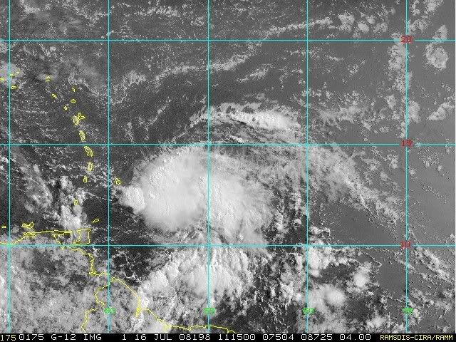
Re: ATL: INVEST 94L East of the Windward Islands
The convection blow-up, has been more impressive than the past few days. But that's made it harder to find the center again. So I think if the convection doesn't wane, they will probably send the plane to find a center today.
0 likes

Re: ATL: INVEST 94L East of the Windward Islands
To my untrained eye, this loop shows 94L becoming better organized.
0 likes
-
HURAKAN
- Professional-Met
- Posts: 46084
- Age: 39
- Joined: Thu May 20, 2004 4:34 pm
- Location: Key West, FL
- Contact:
Re: ATL: INVEST 94L East of the Windward Islands
Conditions at 41101 as of
1100 GMT on 07/16/2008:
Wind Direction (WDIR): NE ( 50 deg true )
Wind Speed (WSPD): 25.1 kts
Wave Height (WVHT): 7.9 ft
Dominant Wave Period (DPD): 7 sec
Atmospheric Pressure (PRES): 29.92 in
Pressure Tendency (PTDY): +0.02 in ( Rising )
Air Temperature (ATMP): 80.4 °F
Water Temperature (WTMP): 81.5 °F
Dew Point (DEWP): 76.3 °F
Heat Index (HEAT): 86.4 °F
0 likes
-
HURAKAN
- Professional-Met
- Posts: 46084
- Age: 39
- Joined: Thu May 20, 2004 4:34 pm
- Location: Key West, FL
- Contact:
Re: ATL: INVEST 94L East of the Windward Islands
TROPICAL WEATHER DISCUSSION
NWS TPC/NATIONAL HURRICANE CENTER MIAMI FL
805 AM EDT WED JUL 16 2008
STRONG TROPICAL WAVE IS ALONG 53W S OF 17N MOVING W NEAR 20 KT
WITH A 1011 MB LOW ANALYZED ALONG THE AXIS NEAR 13N MOVING
ROUGHLY WNW. THE SATELLITE PRESENTATION IS NOT AS WELL DEFINED
AS YESTERDAY BUT CONVECTIVE ACTIVITY THIS MORNING IS ON THE
INCREASE WEST OF THE WAVE AND REMAINS ROUGHLY FOCUSED WITH
SCATTERED MODERATE TO STRONG CONVECTION FROM 11N-14N BETWEEN
53W-58W. THIS SYSTEM IS EXPECTED TO BRING GUSTY WINDS AND
LOCALLY HEAVY RAINFALL TO THE WINDWARD ISLANDS OVER THE NEXT
COUPLE OF DAYS.
0 likes
-
Cryomaniac
- Category 5

- Posts: 1289
- Joined: Tue Aug 15, 2006 2:26 pm
- Location: Newark, Nottinghamshire, UK
- Contact:

Re: ATL: INVEST 94L East of the Windward Islands
Latest QS pass at 9:30 UTC. No closed surface center yet:

0 likes


-
cycloneye

- Admin

- Posts: 149320
- Age: 69
- Joined: Thu Oct 10, 2002 10:54 am
- Location: San Juan, Puerto Rico
Re: ATL: INVEST 94L East of the Windward Islands
ABNT20 KNHC 161145
TWOAT
TROPICAL WEATHER OUTLOOK
NWS TPC/NATIONAL HURRICANE CENTER MIAMI FL
800 AM EDT WED JUL 16 2008
FOR THE NORTH ATLANTIC...CARIBBEAN SEA AND THE GULF OF MEXICO...
THE NATIONAL HURRICANE CENTER IS ISSUING ADVISORIES ON TROPICAL
STORM BERTHA...LOCATED ABOUT 335 MILES NORTHEAST OF BERMUDA.
SATELLITE IMAGES INDICATE THAT THE AREA OF LOW PRESSURE LOCATED
ABOUT 350 MILES EAST OF THE WINDWARD ISLANDS HAS BECOME
BETTER ORGANIZED OVERNIGHT. ALTHOUGH UPPER-LEVEL WINDS ARE ONLY
MARGINALLY CONDUCIVE FOR DEVELOPMENT...THIS SYSTEM STILL HAS THE
POTENTIAL TO BECOME A TROPICAL DEPRESSION TODAY. AN AIR FORCE
RESERVE RECONNAISSANCE AIRCRAFT IS SCHEDULED TO INVESTIGATE THIS
AREA THIS AFTERNOON. REGARDLESS OF DEVELOPMENT...THE SYSTEM IS
EXPECTED TO BRING GUSTY WINDS AND LOCALLY HEAVY RAINS TO THE
WINDWARD ISLANDS DURING THE NEXT DAY OR SO.
ELSEWHERE...TROPICAL CYCLONE FORMATION IS NOT EXPECTED DURING THE
NEXT 48 HOURS.
$$
FORECASTER BLAKE/AVILA
0 likes
Re: ATL: INVEST 94L East of the Windward Islands
wxman57 wrote:Convection has increased, but the lower level circulation is gone today. It's jut an average tropical wave moving into the islands now. It will produce wind gusts as high as 50-60 mph and heavy rainfall as it passes through the islands from this afternoon through tomorrow. Wind shear is too strong for development now.
Just one question wxman57, I am starting to see W & SW winds on the SW quadrant of this system, will this be a typical tropical wave?
0 likes
-
Extremeweatherguy

- Category 5
- Posts: 11095
- Joined: Mon Oct 10, 2005 8:13 pm
- Location: Florida
Who is online
Users browsing this forum: No registered users and 20 guests