TC Bertha

Moderator: S2k Moderators

Message
Author
RL3AO
Moderator-Pro Met
Moderator-Pro Met
Posts: 16308
Joined: Thu Jun 14, 2007 10:03 pm
Location: NC

#141 Postby RL3AO » Tue Jul 01, 2008 2:52 pm

Jeff Masters wrote:A strong tropical wave (Invest 92L) moved off the coast of Africa last night, south of the Cape Verde Islands. This low has the potential to develop into a tropical depression late this week as it moves westwards at 15-20 mph. The low is under about 10 knots of wind shear, which is favorable for development. Sea Surface Temperatures are about 28°C, which is about 2-3°C above average for this date, and well above the 26°C threshold for tropical storm formation. There is not much African dust or dry air near the storm, but so far the low has not been able to generate much heavy thunderstorm activity. The low has plenty of spin, and has developed some broad, curved bands that are a sign of organization. I can't really find any negatives for development, except for climatology--there has never been a tropical depression that has formed east of 34° W longitude in the first half of July (see the first image I posted in yesterday's July Atlantic hurricane outlook). NHC is giving a low chance (less than 20%) that 92L will develop into a tropical depression by Thursday afternoon. Given the system's current disorganization, that's a reasonable forecast. However, all the models are developing this system into a tropical depression by late this week, and I think that the odds rise to a 50% chance of a tropical depression by Saturday. Wind shear is expected to remain low, and the waters will stay warm (above 26°C) for the next 2-3 days of 92L's life.


http://www.wunderground.com/blog/JeffMasters/show.html
0 likes   

User avatar
KWT
Category 5
Category 5
Posts: 31415
Joined: Tue Aug 17, 2004 11:02 am
Location: UK!!!

#142 Postby KWT » Tue Jul 01, 2008 2:58 pm

What should be remembered is there is a powerful low near the UK now (two lows at 990-985mbs) which is serving to allow a slight weakness to the systems north and this is probably allowing a WNW track. I wouldn't be all that surprised to see the wave bend back more to the due west past 3 days as it moves away from the weakness. Eventually I suspect it will recurve but it should be noted the models have at times been very quick in recurving, its well known they do have something of a right bias as seen clearly with Dean last year at times.

Models all in good agreement that it will develop just like they were with Dean last year and if the atmospheric conditions are like they are on the SHIPS or even close then it should have a pretty good set-up to work with, big if of course!
0 likes   

User avatar
NDG
S2K Supporter
S2K Supporter
Posts: 15446
Joined: Sun Jul 09, 2006 10:14 pm
Location: Orlando, FL

#143 Postby NDG » Tue Jul 01, 2008 3:08 pm

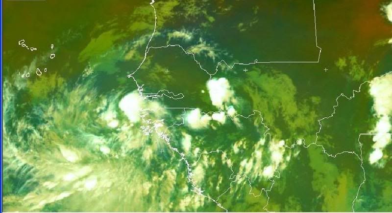
Convection continues to refire
Image
0 likes   

User avatar
Gustywind
Category 5
Category 5
Posts: 12334
Joined: Mon Sep 03, 2007 7:29 am
Location: Baie-Mahault, GUADELOUPE

#144 Postby Gustywind » Tue Jul 01, 2008 3:09 pm

000
FXCA62 TJSJ 011954
AFDSJU

AREA FORECAST DISCUSSION
NATIONAL WEATHER SERVICE SAN JUAN PR
354 PM AST TUE JUL 1 2008

LOOKING WELL AHEAD...A STRONG TROPICAL WAVE OVER THE EXTREME EASTERN ATLANTIC OCEAN NEAR THE WEST COAST OF AFRICA...IS ACCOMPANIED BY A BROAD AREA OF SHOWERS AND THUNDERSTORMS AND PERHAPS A WEAK SURFACE LOW. ENVIRONMENTAL CONDITIONS COULD ALLOW FOR SOME SLOW DEVELOPMENT OF THIS SYSTEM DURING THE NEXT COUPLE OF DAYS AS IT MOVES WESTWARD AT ABOUT 15 TO 20 MPH. HOWEVER...LATEST MODEL GUIDANCE INDICATED THAT THIS SYSTEM WILL PASS WELL NORTHEAST OF THE LOCAL ISLANDS... REPRESENTING ONLY A CONCERN TO THE MARINE COMMUNITY.
0 likes   

User avatar
cycloneye
Admin
Admin
Posts: 145295
Age: 68
Joined: Thu Oct 10, 2002 10:54 am
Location: San Juan, Puerto Rico

Re: INVEST 92L in the Eastern Atlantic

#145 Postby cycloneye » Tue Jul 01, 2008 3:09 pm

:uarrow: That is important because its the diurnal minimun.
0 likes   

User avatar
NDG
S2K Supporter
S2K Supporter
Posts: 15446
Joined: Sun Jul 09, 2006 10:14 pm
Location: Orlando, FL

#146 Postby NDG » Tue Jul 01, 2008 3:13 pm

Yeah, it could mean that it will really refire later tonight or that it is intensifying or becoming better organized. :uarrow:
0 likes   

User avatar
KWT
Category 5
Category 5
Posts: 31415
Joined: Tue Aug 17, 2004 11:02 am
Location: UK!!!

#147 Postby KWT » Tue Jul 01, 2008 3:14 pm

Yep thats re-gaining convection, as you say Hurakan min should be passing through now which is very interesting. Also got a favorable MJO phase over the wave right now.

Still too early to tell about the track, wxman57 says movement is 280 so thats about as good as we know about track right now till the system develops further.
0 likes   

User avatar
NDG
S2K Supporter
S2K Supporter
Posts: 15446
Joined: Sun Jul 09, 2006 10:14 pm
Location: Orlando, FL

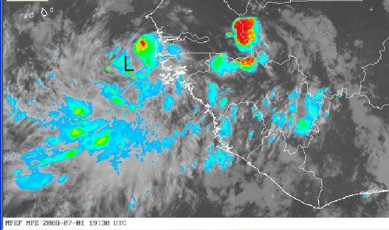
#148 Postby NDG » Tue Jul 01, 2008 3:40 pm

Image
0 likes   

MiamiensisWx

Re:

#149 Postby MiamiensisWx » Tue Jul 01, 2008 3:44 pm

NDG wrote:Image

Can you post a link to these satellite images? I've been audaciously searching for the EUMETSAT data that routinely updates every thirty minutes. Thanks!
0 likes   

User avatar
NDG
S2K Supporter
S2K Supporter
Posts: 15446
Joined: Sun Jul 09, 2006 10:14 pm
Location: Orlando, FL

#150 Postby NDG » Tue Jul 01, 2008 3:45 pm

0 likes   

User avatar
KWT
Category 5
Category 5
Posts: 31415
Joined: Tue Aug 17, 2004 11:02 am
Location: UK!!!

#151 Postby KWT » Tue Jul 01, 2008 3:54 pm

I'm guessing the southern convection is being enhanced by the ITCZ?
Good link by the way!
0 likes   

User avatar
cycloneye
Admin
Admin
Posts: 145295
Age: 68
Joined: Thu Oct 10, 2002 10:54 am
Location: San Juan, Puerto Rico

Re: INVEST 92L in the Eastern Atlantic

#152 Postby cycloneye » Tue Jul 01, 2008 4:09 pm

All the attention for sure is with 92L at this time,but there is something else that opened my eye this afternoon just east of Barbados.Go to talking tropics and see what it is.Maybe invest 93L?
0 likes   

User avatar
Tampa_God
Category 1
Category 1
Posts: 333
Age: 35
Joined: Wed May 31, 2006 7:27 pm
Location: New Port Richey/Trinity, FL

Re: INVEST 92L in the Eastern Atlantic

#153 Postby Tampa_God » Tue Jul 01, 2008 4:15 pm

cycloneye wrote:All the attention for sure is with 92L at this time,but there is something else that cought my eye this afternoon just east of Barbados.Go to talking tropics and see what it is.Maybe invest 93L?

Certainly seems are beginning to fire up in the Atlantic Basin. To have 2 tropical disturbances in the month of July isn't impossible, but highly unheard of. 92L and that other disturbance both look great, with 92& having the better chance to atleast reaching Tropical Storm level.
0 likes   

User avatar
HURAKAN
Professional-Met
Professional-Met
Posts: 46086
Age: 38
Joined: Thu May 20, 2004 4:34 pm
Location: Key West, FL
Contact:

#154 Postby HURAKAN » Tue Jul 01, 2008 4:20 pm

Image

An hour ago.
0 likes   

jhamps10

Re: INVEST 92L in the Eastern Atlantic

#155 Postby jhamps10 » Tue Jul 01, 2008 4:24 pm

Looks like we may have to have development Probelities raised to 50% or larger, for at least by the weekend anyway, and we may get a depression as soon as Thursday.
0 likes   

Ed Mahmoud

Re: INVEST 92L in the Eastern Atlantic

#156 Postby Ed Mahmoud » Tue Jul 01, 2008 4:28 pm

jhamps10 wrote:Looks like we may have to have development Probelities raised to 50% or larger, for at least by the weekend anyway, and we may get a depression as soon as Thursday.


Not a particularly large area of cold cloud tops. I'd wait for more strong storms before I'd go there.
0 likes   

User avatar
KWT
Category 5
Category 5
Posts: 31415
Joined: Tue Aug 17, 2004 11:02 am
Location: UK!!!

#157 Postby KWT » Tue Jul 01, 2008 4:33 pm

I suspect probs will be raised to the orange level. As Ed says the cold cloud tops aren't too widespread just yet though that kay change in the early hours of the morning as we hit the max.
0 likes   

jhamps10

Re: INVEST 92L in the Eastern Atlantic

#158 Postby jhamps10 » Tue Jul 01, 2008 4:37 pm

Ed Mahmoud wrote:
jhamps10 wrote:Looks like we may have to have development Probelities raised to 50% or larger, for at least by the weekend anyway, and we may get a depression as soon as Thursday.


Not a particularly large area of cold cloud tops. I'd wait for more strong storms before I'd go there.


yeah, but it should be around d-min or just past it now, and with shear forecasts to lessen somewhat, but I'm no professional either.
0 likes   

User avatar
wxman57
Moderator-Pro Met
Moderator-Pro Met
Posts: 22978
Age: 67
Joined: Sat Jun 21, 2003 8:06 pm
Location: Houston, TX (southwest)

Re: INVEST 92L in the Eastern Atlantic

#159 Postby wxman57 » Tue Jul 01, 2008 4:44 pm

Ed Mahmoud wrote:
jhamps10 wrote:Looks like we may have to have development Probelities raised to 50% or larger, for at least by the weekend anyway, and we may get a depression as soon as Thursday.


Not a particularly large area of cold cloud tops. I'd wait for more strong storms before I'd go there.


Convection has actually weakened through the day today. The weak low center is well west of the storms inland over west Africa. NHC will most likely just monitor it for the next few days. IF thunderstorms should persist for 24 hours over a well-defined center then it could be upgraded. By this time tomorrow we should have a good idea if it's going to make it. I'd give it a 10-20% shot now, and about a 95-99% chance it's going to be a fish if it develops.

Interesting that the wave behind it over Africa, which also has a circulation, has more convection than 92L now. Probably due to daytime heating, though.
Last edited by wxman57 on Tue Jul 01, 2008 4:51 pm, edited 1 time in total.
0 likes   

User avatar
littlevince
S2K Supporter
S2K Supporter
Posts: 768
Joined: Fri Oct 21, 2005 10:45 am
Location: Portugal

Re: INVEST 92L in the Eastern Atlantic

#160 Postby littlevince » Tue Jul 01, 2008 4:45 pm

Eumetsat IR/Airmass Image Loop (14:00-21:00 UTC)

Image
0 likes   


Return to “2008”

Who is online

Users browsing this forum: No registered users and 5 guests