Arthur's remnents near the BOC

Moderator: S2k Moderators

Message
Author
Matt-hurricanewatcher

Re: INVEST 90L in Western Caribbean

#141 Postby Matt-hurricanewatcher » Fri May 30, 2008 9:51 pm

NDG wrote:
Matt-hurricanewatcher wrote:Looking at the latest Visible I would say that a LLC is forming near 17.1 north/88.2 west. Near land as Derek says. I believe with the convection forming and the banding setting up, that if this had another 6-8 hours; this would be a depression. A well "Organized system" at the mid levels I would say. But it will not have the time to become anything more as Derek says, and I don't disagree. For one the Hurricane models show this system heading more westward, and if they are right then this thing is dead already. If some how this go's more northward it will have to start over again once in the BOC.


I disagree with the both of you, by watching at IR2 loop, it still looks like is offshore, moving very very little WNW or NW.


Personally I believe 80 percent of the LLC is still over water, but it won't take much shift westward to put it over land. It could move a little more northward which would increase the chances of development in the BOC. But its a wait in see...Which is a wise choice to follow.
0 likes   

User avatar
wxman57
Moderator-Pro Met
Moderator-Pro Met
Posts: 22978
Age: 67
Joined: Sat Jun 21, 2003 8:06 pm
Location: Houston, TX (southwest)

Re:

#142 Postby wxman57 » Fri May 30, 2008 10:05 pm

Derek Ortt wrote:looks like the developing center is starting to move back onshore

http://metofis.rsmas.miami.edu/~dortt/s ... 1_loop.gif

I also am starting to think this has a good chance at doing something in the BOC... if it makes it there


I agree, the southern BoC is its only shot, and that's not a good one. Just about zero chance of anything forming in the western Caribbean. It's moving inland already. That blob nearing the isthmus of Mexico looks impressive, but it's over land.
0 likes   

User avatar
GeneratorPower
S2K Supporter
S2K Supporter
Posts: 1648
Age: 45
Joined: Sun Dec 18, 2005 11:48 pm
Location: Huntsville, AL

Re:

#143 Postby GeneratorPower » Fri May 30, 2008 10:06 pm

brunota2003 wrote:Here is my personal take on this system:

It is going to do what it wants to do.


Utterly profound. 8-)
0 likes   

User avatar
GeneratorPower
S2K Supporter
S2K Supporter
Posts: 1648
Age: 45
Joined: Sun Dec 18, 2005 11:48 pm
Location: Huntsville, AL

Re:

#144 Postby GeneratorPower » Fri May 30, 2008 10:07 pm

RL3AO wrote:Quit ripping on the LBAR. It got it right once last year.


Even a stopped clock is right twice a day.
0 likes   

User avatar
NDG
S2K Supporter
S2K Supporter
Posts: 15446
Joined: Sun Jul 09, 2006 10:14 pm
Location: Orlando, FL

Re: Re:

#145 Postby NDG » Fri May 30, 2008 10:21 pm

wxman57 wrote:
Derek Ortt wrote:looks like the developing center is starting to move back onshore

http://metofis.rsmas.miami.edu/~dortt/s ... 1_loop.gif

I also am starting to think this has a good chance at doing something in the BOC... if it makes it there


I agree, the southern BoC is its only shot, and that's not a good one. Just about zero chance of anything forming in the western Caribbean. It's moving inland already. That blob nearing the isthmus of Mexico looks impressive, but it's over land.


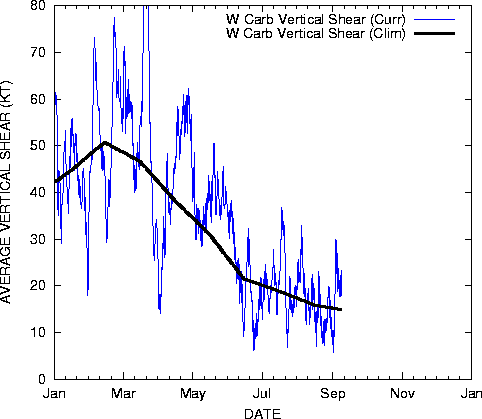
What you guys think of the UL environment how well it looks for this time of the year?

Image
0 likes   

User avatar
vaffie
Category 3
Category 3
Posts: 898
Joined: Sat Sep 11, 2004 5:11 pm
Location: Houston, Texas

Re: INVEST 90L in Western Caribbean

#146 Postby vaffie » Fri May 30, 2008 10:22 pm

Wind gusts up to 36mph at the nearest buoy. Might still make it to tropical depression strength before coming onshore.

http://www.ndbc.noaa.gov/station_page.php?station=42056
0 likes   

Derek Ortt

#147 Postby Derek Ortt » Fri May 30, 2008 10:23 pm

environment looks typical for being underneath an UH

overall, the shear is a little weaker than normal
0 likes   

User avatar
wxman57
Moderator-Pro Met
Moderator-Pro Met
Posts: 22978
Age: 67
Joined: Sat Jun 21, 2003 8:06 pm
Location: Houston, TX (southwest)

Re: INVEST 90L in Western Caribbean

#148 Postby wxman57 » Fri May 30, 2008 10:27 pm

vaffie wrote:Wind gusts up to 36mph at the nearest buoy. Might still make it to tropical depression strength before coming onshore.

http://www.ndbc.noaa.gov/station_page.php?station=42056


That's not representative of any circulation, it's just wind beneath that thunderstorm cluster. Winds out from beneath the storm are 10-15 kts offshore Belize. What LLC there was is moving inland now (or is inland already). No chance of development in western Caribbean.
0 likes   

User avatar
Chacor
Category 5
Category 5
Posts: 10229
Joined: Mon Oct 02, 2006 10:43 pm
Location: Singapore

#149 Postby Chacor » Fri May 30, 2008 10:39 pm

EPac TWD:

AREAS OF HEAVY RAIN CONTINUE TO AFFECT PORTIONS OF CENTRAL
AMERICA AND S MEXICO/YUCATAN PENINSULA. THIS ACTIVITY IS
ASSOCIATED WITH THE REMNANTS OF TROPICAL STORM ALMA AND A
TROPICAL WAVE. THESE FEATURES CONSOLIDATED INTO A 1005 MB LOW
PRES SYSTEM CENTERED JUST E OF BELIZE. WHILE DEVELOPMENT INTO A
TROPICAL DEPRESSION APPEARS UNLIKELY DUE TO THE CLOSE PROXIMITY
TO LAND...HEAVY RAIN/FLOODING IS POSSIBLE OVER THE NEXT COUPLE
OF DAYS FROM HONDURAS TO SOUTHERN MEXICO.
0 likes   

User avatar
cycloneye
Admin
Admin
Posts: 145295
Age: 68
Joined: Thu Oct 10, 2002 10:54 am
Location: San Juan, Puerto Rico

Re: INVEST 90L Models Thread

#150 Postby cycloneye » Fri May 30, 2008 10:49 pm

00z GFS at 42 Hours It has the low in the extreme southern part of the BOC.

00z GFS at 60 Hours Low is inland in Mexico.

00z GFS at 168 Hours Another low forms and is at the NE tip of Yucatan.

00z GFS at 204 Hours Look what happens at this timeframe.End of drought and fire dangers in Florida Peninsula?
0 likes   

User avatar
dixiebreeze
S2K Supporter
S2K Supporter
Posts: 5140
Joined: Wed Sep 03, 2003 5:07 pm
Location: crystal river, fla.

Re: INVEST 90L in Western Caribbean

#151 Postby dixiebreeze » Fri May 30, 2008 10:55 pm

Atlantic Ocean Basin: Imagery

DATE/TIME LAT LON CLASSIFICATION STORM
30/2345 UTC 16.8N 87.8W TOO WEAK 90L
0 likes   

User avatar
tailgater
S2K Supporter
S2K Supporter
Posts: 3339
Joined: Sun Jul 11, 2004 9:13 pm
Location: St. Amant La.

Re: INVEST 90L in Western Caribbean

#152 Postby tailgater » Fri May 30, 2008 11:21 pm

wxman57 wrote:
vaffie wrote:Wind gusts up to 36mph at the nearest buoy. Might still make it to tropical depression strength before coming onshore.

http://www.ndbc.noaa.gov/station_page.php?station=42056


That's not representative of any circulation, it's just wind beneath that thunderstorm cluster. Winds out from beneath the storm are 10-15 kts offshore Belize. What LLC there was is moving inland now (or is inland already). No chance of development in western Caribbean.

I don't see how anyone can tell if there is a real LLC, or which way it's moving, with at best, scattered surface obs and IR sat. The winds at that buoy have fairly strong for the last 4 hrs.
0 likes   

User avatar
wxman57
Moderator-Pro Met
Moderator-Pro Met
Posts: 22978
Age: 67
Joined: Sat Jun 21, 2003 8:06 pm
Location: Houston, TX (southwest)

Re: INVEST 90L in Western Caribbean

#153 Postby wxman57 » Fri May 30, 2008 11:22 pm

tailgater wrote:I don't see how anyone can tell if there is a real LLC, or which way it's moving, with at best, scattered surface obs and IR sat. The winds at that buoy have fairly strong for the last 4 hrs.


You certainly can't tell easily with satellite. I plotted surface obs to find the broad, weak low earlier today. It's not as well-defined now, but what's left of it is now inland.
0 likes   

User avatar
NDG
S2K Supporter
S2K Supporter
Posts: 15446
Joined: Sun Jul 09, 2006 10:14 pm
Location: Orlando, FL

#154 Postby NDG » Fri May 30, 2008 11:47 pm

Whoa, 44kts winds under the convection NE of Belize recently reported by a ship along with 10' waves.

SHIP S 0300 18.80 -86.10 168 358 100 44.1 - 9.8 1.0 - - 29.80 +0.06 78.8 80.6 - 6.2
0 likes   

User avatar
tailgater
S2K Supporter
S2K Supporter
Posts: 3339
Joined: Sun Jul 11, 2004 9:13 pm
Location: St. Amant La.

Re:

#155 Postby tailgater » Sat May 31, 2008 12:03 am

NDG wrote:Whoa, 44kts winds under the convection NE of Belize recently reported by a ship along with 10' waves.

SHIP S 0300 18.80 -86.10 168 358 100 44.1 - 9.8 1.0 - - 29.80 +0.06 78.8 80.6 - 6.2


If that's a good report then this little booger is getting trying to get our attention.

http://www.ssd.noaa.gov/goes/flt/t1/loop-rb.html
on this loop it looks like the lower clouds over Belize are moving north to south, but I realize it's colored IR
0 likes   

User avatar
NDG
S2K Supporter
S2K Supporter
Posts: 15446
Joined: Sun Jul 09, 2006 10:14 pm
Location: Orlando, FL

Re: Re:

#156 Postby NDG » Sat May 31, 2008 12:12 am

tailgater wrote:
NDG wrote:Whoa, 44kts winds under the convection NE of Belize recently reported by a ship along with 10' waves.

SHIP S 0300 18.80 -86.10 168 358 100 44.1 - 9.8 1.0 - - 29.80 +0.06 78.8 80.6 - 6.2


If that's a good report then this little booger is getting trying to get our attention.

http://www.ssd.noaa.gov/goes/flt/t1/loop-rb.html
on this loop it looks like the lower clouds over Belize are moving north to south, but I realize it's colored IR


Yeah, I was looking at that as well, that is why I would not be surprised if the LLC or most of circulation center is still offshore, barely. I wish that there were some reports from Belize, but they stopped reporting since early in the evening.
0 likes   

User avatar
Recurve
Category 5
Category 5
Posts: 1640
Joined: Tue Aug 16, 2005 8:59 pm
Location: St. Petersburg, FL

Re: INVEST 90L in Western Caribbean / Yucatan Penninsula

#157 Postby Recurve » Sat May 31, 2008 12:24 am

nothin is developing out of some widely scattered convection in the Wcaribb.
There will be no "center."
Listen to the obs. 10-15 knots winds outside thunderstorms.
This thing is a rainmaker for Mexico at best.

I wish that high weren't squashing the moisture down to Cuba. Another 100 miles north or so and we'd have some nice rain over SFla
0 likes   

Matt-hurricanewatcher

Re: INVEST 90L in Western Caribbean / Yucatan Penninsula

#158 Postby Matt-hurricanewatcher » Sat May 31, 2008 12:29 am

This thing has a very nice sphere of outflow around it. Meaning very favorable upper level envirnoment to work with, so if it was not for the Yuctan I would be going nuts with this system. Based on latest satellite I would say the center is about half way on the coast near 17.2 north/88.4 west, but convection appears to be forming over it big time. I would not be suprized if this had a "LLC" or was very close to be closing one off as its moving onshore...But it won't have a chance now.

As it moves over the Yuctan, that will take 24+ hours it won't have much lefted/
0 likes   

User avatar
NDG
S2K Supporter
S2K Supporter
Posts: 15446
Joined: Sun Jul 09, 2006 10:14 pm
Location: Orlando, FL

#159 Postby NDG » Sat May 31, 2008 12:36 am

8-9' waves are not created by 10-15 knot winds.
And guess what, in weak systems, the strongest winds are found near convection.

Winds gusting to 33 mph, with a temp of 81 deg F, it is not from convective outflows.

Conditions at 42056 as of
0450 GMT on 05/31/2008

Wind Direction (WDIR): ESE ( 110 deg true )
Wind Speed (WSPD): 25.3 kts
Wind Gust (GST): 29.1 kts
Wave Height (WVHT): 8.5 ft
Dominant Wave Period (DPD): 8 sec
Average Period (APD): 5.4 sec
Mean Wave Direction (MWD): SSE ( 147 deg true )
Atmospheric Pressure (PRES): 29.93 in
Pressure Tendency (PTDY): +0.03 in ( Rising )
Air Temperature (ATMP): 81.1 °F
Water Temperature (WTMP): 82.9 °F
Dew Point (DEWP): 75.0 °F
Heat Index (HEAT): 87.1 °F
0 likes   

User avatar
Recurve
Category 5
Category 5
Posts: 1640
Joined: Tue Aug 16, 2005 8:59 pm
Location: St. Petersburg, FL

Re: INVEST 90L Models Thread

#160 Postby Recurve » Sat May 31, 2008 12:37 am

Wasn't the GFS at 200 hours showing that a week ago? It would be great to get a low and a slug of tropical moisture over Florida without a storm hitting us.
0 likes   


Return to “2008”

Who is online

Users browsing this forum: No registered users and 5 guests