ATL: Tropical Depression Fay

Moderator: S2k Moderators

Message
Author
User avatar
SouthFLTropics
Category 5
Category 5
Posts: 4236
Age: 50
Joined: Thu Aug 14, 2003 8:04 am
Location: Port St. Lucie, Florida

Re: ATL: Invest 92L in Central Atlantic

#1261 Postby SouthFLTropics » Tue Aug 12, 2008 7:00 pm

It has the appearance of a ghost hurricane...Currently has the look but nothing but vapor. Now the question is this...Does it stay as a Casper the Friendly Ghost :D , or does it turn into more like Freddy Krueger :grrr:

:thinking:

SouthFLTropics
0 likes   

User avatar
HURAKAN
Professional-Met
Professional-Met
Posts: 46086
Age: 38
Joined: Thu May 20, 2004 4:34 pm
Location: Key West, FL
Contact:

#1262 Postby HURAKAN » Tue Aug 12, 2008 7:00 pm

Let tell you something, the MLC is impressive and if strong convection can develop over it, a LLC may for quickly.

Loop: http://rammb.cira.colostate.edu/ramsdis ... _floater_1

The faster, the better you will see the MLC.
0 likes   

User avatar
canegrl04
Category 5
Category 5
Posts: 2486
Joined: Thu Aug 26, 2004 5:37 pm
Location: Texas

#1263 Postby canegrl04 » Tue Aug 12, 2008 7:01 pm

This reminds me of 94L before it became hurricane Dolly.Just becuz it looks ragged right now doesn't mean it can't become a formidable force down the road
0 likes   

Scorpion

#1264 Postby Scorpion » Tue Aug 12, 2008 7:02 pm

The convection is bad but the structure looks decent.
0 likes   

User avatar
KWT
Category 5
Category 5
Posts: 31415
Joined: Tue Aug 17, 2004 11:02 am
Location: UK!!!

#1265 Postby KWT » Tue Aug 12, 2008 7:04 pm

Of course it has got a good structure, at least at the mid levels but the key is will we get a good convective burst because if it doesn't then the circulation will slowly weaken even at mid-level but we shall see, I suspect eventually convection will fire up again.
0 likes   

User avatar
Blown Away
S2K Supporter
S2K Supporter
Posts: 10147
Joined: Wed May 26, 2004 6:17 am

Re: ATL: Invest 92L in Central Atlantic

#1266 Postby Blown Away » Tue Aug 12, 2008 7:05 pm

Nice clear rotation and convection building directly on top of the circulation (17.2N/53W). Structure wise 92L looks better than it has since it was classified. Finally, it looks like a tropical system. I'm not going to predict anything, to me it looks good rate now and the structure is now allowing the convection to build near the center.
http://www.ssd.noaa.gov/goes/flt/t1/loop-avn.html
0 likes   

User avatar
SouthFLTropics
Category 5
Category 5
Posts: 4236
Age: 50
Joined: Thu Aug 14, 2003 8:04 am
Location: Port St. Lucie, Florida

Re:

#1267 Postby SouthFLTropics » Tue Aug 12, 2008 7:08 pm

canegrl04 wrote:This reminds me of 94L before it became hurricane Dolly.Just becuz it looks ragged right now doesn't mean it can't become a formidable force down the road


Agreed canegrl04...This is very concerning in my part of the world. I'm hoping it stays a ghost but the synoptic setup is very bothersome for me. Frances, Jeanne, and Wilma are fresh in my mind. I'm not really looking forward to that mess again. But, if it comes, at least I'm prepared. I guess I better relax now because there could be some long hours in the weeks ahead. My company manages hurricane restoration and recovery work for FDOT...After a storm it means 18+ hour days... :double:
0 likes   

User avatar
HURAKAN
Professional-Met
Professional-Met
Posts: 46086
Age: 38
Joined: Thu May 20, 2004 4:34 pm
Location: Key West, FL
Contact:

#1268 Postby HURAKAN » Tue Aug 12, 2008 7:10 pm

It seems the Leeward Islands are in the clear if the MLC becomes the dominant feature as it looks like at the moment.
0 likes   

User avatar
cycloneye
Admin
Admin
Posts: 145455
Age: 68
Joined: Thu Oct 10, 2002 10:54 am
Location: San Juan, Puerto Rico

Re:

#1269 Postby cycloneye » Tue Aug 12, 2008 7:11 pm

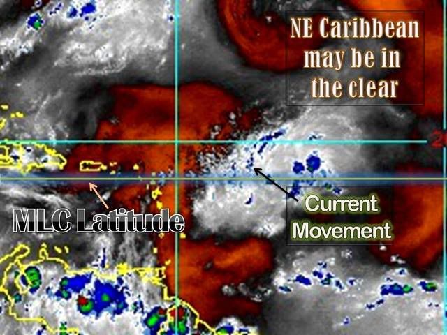
HURAKAN wrote:It seems the Leeward Islands are in the clear if the MLC becomes the dominant feature as it looks like at the moment.


I agree about that.Only some rain if the track is like it seems to take around 20n north of Puerto Rico.
0 likes   

Derek Ortt

#1270 Postby Derek Ortt » Tue Aug 12, 2008 7:14 pm

shouldn't the thread reflect the change in the graphical TWO from red to orange? (or am I too late?)
0 likes   

RL3AO
Moderator-Pro Met
Moderator-Pro Met
Posts: 16308
Joined: Thu Jun 14, 2007 10:03 pm
Location: NC

#1271 Postby RL3AO » Tue Aug 12, 2008 7:15 pm

Back down to orange.

Image
0 likes   

Derek Ortt

#1272 Postby Derek Ortt » Tue Aug 12, 2008 7:19 pm

development chances are falling quickly

if this does not generate convection overnight, it'll be next invest please in the morning
0 likes   

User avatar
Jam151
Category 1
Category 1
Posts: 276
Joined: Fri Aug 26, 2005 12:09 pm

Re: ATL: Invest 92L in Central Atlantic

#1273 Postby Jam151 » Tue Aug 12, 2008 7:22 pm

Ya b/c convection never fizzles in the early evening and no such models like the GFDL are suggesting a Cat 4 in 5 days... :lol: . I think the NHC 48 hour TWO is spot on.
0 likes   

User avatar
HURAKAN
Professional-Met
Professional-Met
Posts: 46086
Age: 38
Joined: Thu May 20, 2004 4:34 pm
Location: Key West, FL
Contact:

#1274 Postby HURAKAN » Tue Aug 12, 2008 7:23 pm

Image
0 likes   

Stratosphere747
Category 5
Category 5
Posts: 3772
Joined: Thu Sep 11, 2003 8:34 pm
Location: Surfside Beach/Freeport Tx
Contact:

Re: ATL: Invest 92L in Central Atlantic

#1275 Postby Stratosphere747 » Tue Aug 12, 2008 7:28 pm

TROPICAL WEATHER DISCUSSION
NWS TPC/NATIONAL HURRICANE CENTER MIAMI FL
805 PM EDT TUE AUG 12 2008

...SPECIAL FEATURES...
TROPICAL WAVE IS IN THE W TROPICAL ATLANTIC ALONG 52W S OF 21N
OR ABOUT 500 NM E OF THE LESSER ANTILLES WITH A 1008 MB LOW
ALONG THE WAVE NEAR 16N MOVING W 10-15 KT. SCATTERED SHOWERS/
ISOLATED THUNDERSTORMS ARE N OF THE LOW FROM 16N-20N BETWEEN
48W-54W. A TROPICAL DEPRESSION COULD FORM DURING THE NEXT DAY OR
SO WITH THE SHOWER ACTIVITY MOVING OVER BARBADOS LATE TONIGHT.
0 likes   

User avatar
Aquawind
Category 5
Category 5
Posts: 6714
Age: 62
Joined: Mon Jun 16, 2003 10:41 pm
Location: Salisbury, NC
Contact:

Re: ATL: Invest 92L in Central Atlantic

#1276 Postby Aquawind » Tue Aug 12, 2008 7:35 pm

Well the convection continues to refire over the MLC. Tiny as it is...92L LIVES!!

http://www.ssd.noaa.gov/goes/flt/t1/loop-ir2.html
0 likes   

User avatar
HURAKAN
Professional-Met
Professional-Met
Posts: 46086
Age: 38
Joined: Thu May 20, 2004 4:34 pm
Location: Key West, FL
Contact:

#1277 Postby HURAKAN » Tue Aug 12, 2008 7:38 pm

Image

Right now most of the convection in the Atlantic is weak.
0 likes   

Jason_B

Re: ATL: Invest 92L in Central Atlantic

#1278 Postby Jason_B » Tue Aug 12, 2008 7:38 pm

I don't know about a cat 3/4 storm, but I do have a feeling something will come of this later down the road. I don't really have anything to back that up, it's just when I see this system I think back to when everybody wrote off 94L and we all know what became of that. So just give it time, we all know how quick things change out there.
0 likes   

User avatar
deltadog03
Professional-Met
Professional-Met
Posts: 3580
Joined: Tue Jul 05, 2005 6:16 pm
Location: Macon, GA

#1279 Postby deltadog03 » Tue Aug 12, 2008 7:42 pm

The SW part of the system is dying...That means the "center" or MLC should start getting everything into it.
0 likes   

User avatar
Vortex
S2K Supporter
S2K Supporter
Posts: 4644
Age: 53
Joined: Fri Aug 01, 2003 9:34 pm
Location: Hilton Head, SC

#1280 Postby Vortex » Tue Aug 12, 2008 7:47 pm

00:15 utc imagery depicts very deep convection firing right over the mlc!
0 likes   


Return to “2008”

Who is online

Users browsing this forum: No registered users and 5 guests