ATL: Tropical Depression Fay

Moderator: S2k Moderators

Message
Author
User avatar
HURAKAN
Professional-Met
Professional-Met
Posts: 46086
Age: 38
Joined: Thu May 20, 2004 4:34 pm
Location: Key West, FL
Contact:

Re:

#1141 Postby HURAKAN » Tue Aug 12, 2008 3:00 pm

Honeyko wrote:This very obviously has a closed circulation now, and has had persistent convection as well...what's the hold-up with declaring it a TD?

Many declared TDs have weakened to much worse-looking states, and managed to retrain a TD label.


And the RECON is in France and we're the 9th planet from the Sun. 8-)
0 likes   

Stormcenter
S2K Supporter
S2K Supporter
Posts: 6684
Joined: Wed Sep 03, 2003 11:27 am
Location: Houston, TX

Re: ATL: Invest 92L - Central Atlantic - TCFA issued

#1142 Postby Stormcenter » Tue Aug 12, 2008 3:01 pm

txag2005 wrote:What is the chance of development in everyone's opinion? Looks fairly low based on most comments on here.


In the tropics during the month of August I say any disturbance
has a chance. I would put this one at 50/50.
0 likes   

Ed Mahmoud

Re: Re:

#1143 Postby Ed Mahmoud » Tue Aug 12, 2008 3:02 pm

cycloneye wrote:
Honeyko wrote:This very obviously has a closed circulation now, and has had persistent convection as well...what's the hold-up with declaring it a TD?

Many declared TDs have weakened to much worse-looking states, and managed to retrain a TD label.


But recon has not found a LLC.


Recon needed to get a bit further South than 14.8ºN, IMHO. My amateur eyeballs are guessing that if an LLC is present (if), it is about 14.8ºN, 52.5ºW
0 likes   

User avatar
KWT
Category 5
Category 5
Posts: 31415
Joined: Tue Aug 17, 2004 11:02 am
Location: UK!!!

#1144 Postby KWT » Tue Aug 12, 2008 3:05 pm

The problem is Ed if anything is down there then there is pretty much nex to nothing in terms of convection bar a tiny amount of that sao called pop corn convection. Saying that lower pressures were found down around 14.8N but no LLC.
0 likes   

User avatar
HURAKAN
Professional-Met
Professional-Met
Posts: 46086
Age: 38
Joined: Thu May 20, 2004 4:34 pm
Location: Key West, FL
Contact:

#1145 Postby HURAKAN » Tue Aug 12, 2008 3:10 pm

0 likes   

User avatar
gatorcane
S2K Supporter
S2K Supporter
Posts: 23691
Age: 47
Joined: Sun Mar 13, 2005 3:54 pm
Location: Boca Raton, FL

Re: ATL: Invest 92L - Central Atlantic - TCFA issued

#1146 Postby gatorcane » Tue Aug 12, 2008 3:13 pm

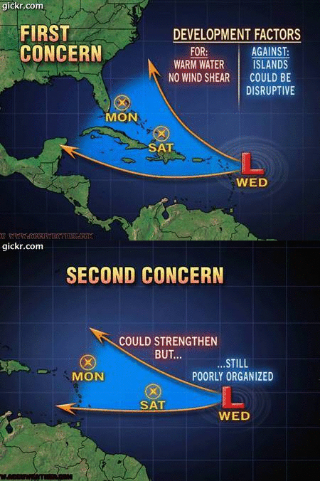
well Accuweather has it headed in the general direction of Southern Florida. Go figure....
0 likes   

User avatar
artist
Category 5
Category 5
Posts: 9792
Joined: Mon Jun 06, 2005 3:26 pm
Location: West Palm

Re:

#1147 Postby artist » Tue Aug 12, 2008 3:17 pm


according to them it looks like a Jeanne or Frances hit. Let's see what tomorrow brings.
I hate this watching and waiting...
0 likes   

User avatar
cycloneye
Admin
Admin
Posts: 145438
Age: 68
Joined: Thu Oct 10, 2002 10:54 am
Location: San Juan, Puerto Rico

Re: ATL: Invest 92L - Central Atlantic - TCFA issued

#1148 Postby cycloneye » Tue Aug 12, 2008 3:18 pm

:uarrow: Those are the mother of cones!
0 likes   

User avatar
DESTRUCTION5
Category 5
Category 5
Posts: 4423
Age: 43
Joined: Wed Sep 03, 2003 11:25 am
Location: Stuart, FL

#1149 Postby DESTRUCTION5 » Tue Aug 12, 2008 3:21 pm

:uarrow:

Love how concern 1 was not down the middle of the cone because if it was it would be over Lake Okeechobee..
0 likes   

Honeyko

Re: Re:

#1150 Postby Honeyko » Tue Aug 12, 2008 3:22 pm

Ed Mahmoud wrote:
cycloneye wrote:
Honeyko wrote:This very obviously has a closed circulation now, and has had persistent convection as well...what's the hold-up with declaring it a TD? Many declared TDs have weakened to much worse-looking states, and managed to retrain a TD label.
But recon has not found a LLC.
Recon needed to get a bit further South than 14.8ºN, IMHO. My amateur eyeballs are guessing that if an LLC is present (if), it is about 14.8ºN, 52.5ºW
I sometimes gather the strong impression that Recon needs a live chat-link to an amateur at home with a laptop in bed (he'd be wearing his pajamas, of course, being one of those "new media" types) watching VIS loops while holding a dark mouse arrow in front of various parts to see where surface elements on the south side are scooting left to right from an objective frame of reference.

Image
Last edited by Honeyko on Tue Aug 12, 2008 3:25 pm, edited 1 time in total.
0 likes   

Ed Mahmoud

Re: Re:

#1151 Postby Ed Mahmoud » Tue Aug 12, 2008 3:22 pm

artist wrote:


according to them it looks like a Jeanne or Frances hit. Let's see what tomorrow brings.
I hate this watching and waiting...


No wind shear?

Looks like between 10 and 20 knots per CIMMS, and it has the appearance of a system battling shear.
0 likes   

User avatar
Vortex
S2K Supporter
S2K Supporter
Posts: 4644
Age: 53
Joined: Fri Aug 01, 2003 9:34 pm
Location: Hilton Head, SC

#1152 Postby Vortex » Tue Aug 12, 2008 3:22 pm

18Z NAM rolling in..

Looks like a very favorable upper air environment over the next few days..


http://www.nco.ncep.noaa.gov/pmb/nwprod ... loop.shtml
0 likes   

User avatar
jrod
Military Member
Military Member
Posts: 546
Joined: Fri Jun 17, 2005 1:22 pm
Location: jacksonville, fl

Re: ATL: Invest 92L - Central Atlantic - TCFA issued

#1153 Postby jrod » Tue Aug 12, 2008 3:23 pm

There is some model support for a Florida impact, obviously anything over 144hrs++++ need to be looked at with a grain of salt. Besides there are enough top pro's on here who aren't giving it much of a chance to make me doubtful at least in the short term of significant development here.

Image
0 likes   

User avatar
Aquawind
Category 5
Category 5
Posts: 6714
Age: 62
Joined: Mon Jun 16, 2003 10:41 pm
Location: Salisbury, NC
Contact:

#1154 Postby Aquawind » Tue Aug 12, 2008 3:25 pm

Woah..937mb?
0 likes   

User avatar
KWT
Category 5
Category 5
Posts: 31415
Joined: Tue Aug 17, 2004 11:02 am
Location: UK!!!

#1155 Postby KWT » Tue Aug 12, 2008 3:25 pm

I think that they are talking about the future track Ed, the GFS does show a very low wind shear set-up after 48-72hrs.
0 likes   

Derek Ortt

#1156 Postby Derek Ortt » Tue Aug 12, 2008 3:25 pm

recon very unimpressive

nothing to see folks
0 likes   

User avatar
KWT
Category 5
Category 5
Posts: 31415
Joined: Tue Aug 17, 2004 11:02 am
Location: UK!!!

#1157 Postby KWT » Tue Aug 12, 2008 3:25 pm

I think that they are talking about the future track Ed, the GFS does show a very low wind shear set-up after 48-72hrs.
0 likes   

User avatar
gatorcane
S2K Supporter
S2K Supporter
Posts: 23691
Age: 47
Joined: Sun Mar 13, 2005 3:54 pm
Location: Boca Raton, FL

#1158 Postby gatorcane » Tue Aug 12, 2008 3:25 pm

Another SE Florida hit, looks to be very near or over Palm Beach County.

NHC gives it a high probability also so I'd say there is every reason in the world to closely monitor 92L and maybe future Fay. :uarrow: :uarrow:
0 likes   

User avatar
HURAKAN
Professional-Met
Professional-Met
Posts: 46086
Age: 38
Joined: Thu May 20, 2004 4:34 pm
Location: Key West, FL
Contact:

#1159 Postby HURAKAN » Tue Aug 12, 2008 3:26 pm

12/1745 UTC 15.7N 53.2W T1.0/1.0 92L
0 likes   

MiamiensisWx

Re:

#1160 Postby MiamiensisWx » Tue Aug 12, 2008 3:26 pm

Aquawind wrote:Woah..937mb?

It's actually ~987 mb...

It's also the long range of the Canadian model.
Last edited by MiamiensisWx on Tue Aug 12, 2008 3:27 pm, edited 1 time in total.
0 likes   


Return to “2008”

Who is online

Users browsing this forum: No registered users and 5 guests