ATL: Tropical Depression Fay
Moderator: S2k Moderators
-
CourierPR

- Category 5

- Posts: 1336
- Age: 72
- Joined: Tue Aug 31, 2004 7:53 pm
- Location: Pompano Beach, Florida
Re: ATL: Invest 92L - Central Atlantic - TCFA issued
"She's still alive, Jim." Dr. McCoy speaks.
0 likes

-
CourierPR
- Category 5
- Posts: 1336
- Age: 72
- Joined: Tue Aug 31, 2004 7:53 pm
- Location: Pompano Beach, Florida
Re: ATL: Invest 92L - Central Atlantic - TCFA issued
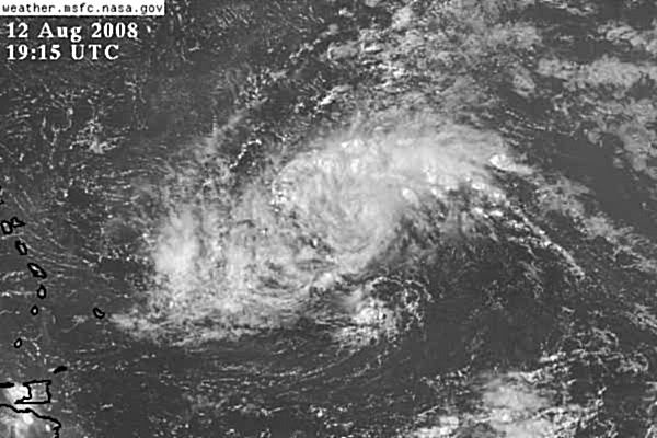
Sandy, what is your opinion from looking at that photo?
Last edited by CourierPR on Tue Aug 12, 2008 2:34 pm, edited 1 time in total.
0 likes

Re: ATL: Invest 92L - Central Atlantic - TCFA issued
alienstorm wrote:Latest High Resolution shot (18:45Z) shows popecorn Thunderstorms firing up in a curling fashion extending from NE to West. We should start seeing increase activity overnight and then things may get interesting.
Yep indeed need this to continue for it to get going. Problem is the convection just hasn't been holding long enough for a LLC to get going.
Hurakan, not a bad looking system but convection has certainly weakened recently.
0 likes
-
HURAKAN

- Professional-Met

- Posts: 46084
- Age: 39
- Joined: Thu May 20, 2004 4:34 pm
- Location: Key West, FL
- Contact:
Re: ATL: Invest 92L - Central Atlantic - TCFA issued
CourierPR wrote:Sandy, what is your opinion from looking at that photo?
Looks like it's trying to organize but it seems everything is not ready for this to crank up. I think the Leeward Islands and Puerto Rico will see an increase in precipitation over the next few days and a few gusty winds. The residents in the area should prepare for the possibility of flooding and mudslides but at this time I don't think winds will be a problem. Moreover, there is still the possibility for this system to pass further north. We will have to see.
Personal Forecast Disclaimer:
The posts in this forum are NOT official forecast and should not be used as such. They are just the opinion of the poster and may or may not be backed by sound meteorological data. They are NOT endorsed by any professional institution or storm2k.org. For official information, please refer to the NHC and NWS products.
0 likes

-
cycloneye

- Admin

- Posts: 149319
- Age: 69
- Joined: Thu Oct 10, 2002 10:54 am
- Location: San Juan, Puerto Rico
Re:
Vortex wrote:the convection will come as the foundation is being layed out as we speak..
What do you mean by that? Remember,there are plenty of new guests here that are novices and dont know those terms.
0 likes
-
alienstorm

- Category 1

- Posts: 496
- Joined: Tue Jul 31, 2007 1:29 pm
- Location: Miami Fla western suburb
Re: ATL: Invest 92L - Central Atlantic - TCFA issued
What is the link for the google tropical atlantic recon site.
0 likes
Re: ATL: Invest 92L - Central Atlantic - TCFA issued
alienstorm wrote:What is the link for the google tropical atlantic recon site.
http://www.nhc.noaa.gov/reconlist.shtml
0 likes
-
haml8

- Tropical Storm

- Posts: 188
- Age: 50
- Joined: Sun Aug 19, 2007 10:03 pm
- Location: Katy, Texas
- Contact:
Re: ATL: Invest 92L - Central Atlantic - TCFA issued
alienstorm wrote:What is the link for the google tropical atlantic recon site.
This is where I got it
http://bbs.keyhole.com/ubb/showflat.php/Cat/0/Number/1206119/an/0/page/0
0 likes
Re: ATL: Invest 92L - Central Atlantic - TCFA issued
What is the chance of development in everyone's opinion? Looks fairly low based on most comments on here.
0 likes
-
HURAKAN
- Professional-Met
- Posts: 46084
- Age: 39
- Joined: Thu May 20, 2004 4:34 pm
- Location: Key West, FL
- Contact:
Re: ATL: Invest 92L - Central Atlantic - TCFA issued
txag2005 wrote:What is the chance of development in everyone's opinion? Looks fairly low based on most comments on here.
The comments concern the system's appearance at the moment. We're in August and anything moving towards land must be watched carefully.
0 likes
-
Honeyko
-
Stormcenter
- S2K Supporter

- Posts: 6689
- Joined: Wed Sep 03, 2003 11:27 am
- Location: Houston, TX
Re: ATL: Invest 92L - Central Atlantic - TCFA issued
The area of convection in the SW Carribean looks more
impressive then 92L.
http://www.ssd.noaa.gov/goes/east/carb/loop-avn.html
impressive then 92L.
http://www.ssd.noaa.gov/goes/east/carb/loop-avn.html
0 likes
-
cycloneye
- Admin
- Posts: 149319
- Age: 69
- Joined: Thu Oct 10, 2002 10:54 am
- Location: San Juan, Puerto Rico
Re:
Honeyko wrote:This very obviously has a closed circulation now, and has had persistent convection as well...what's the hold-up with declaring it a TD?
Many declared TDs have weakened to much worse-looking states, and managed to retrain a TD label.
But recon has not found a LLC.
0 likes
Who is online
Users browsing this forum: No registered users and 50 guests