ATL: Tropical Depression Dolly
Moderator: S2k Moderators
-
Matt-hurricanewatcher
Re: ATL: INVEST 94L East of the Windward Islands
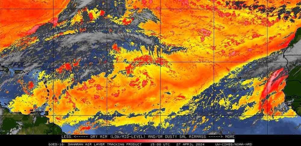
I see it Derek, also that tail is a sign that the SAL is close. So the maps at cimss are not always very good.
0 likes


The GDFL insists on developing 94L to a tropical storm (actually as a stronger one than predicted on the previous run) and moving its center just south of Barbados on Wednesday. The projected track is so similar to the previous one that I thought it hadn't been updated.
So I'm not letting my guard down on this one, especially with convection flaring as it is.
So I'm not letting my guard down on this one, especially with convection flaring as it is.
0 likes
-
Blown Away

- S2K Supporter

- Posts: 10253
- Joined: Wed May 26, 2004 6:17 am
Re: ATL: INVEST 94L East of the Windward Islands
Matt-hurricanewatcher wrote:I don't expect a upgrade today unless things change big time.
Things have changed quite a bit from 6 hours ago when 94L was mostly void of any deep convection, except for some small burts near the LLC.
0 likes

Re: ATL: INVEST 94L East of the Windward Islands
Looking at visible images, it looks like the center trying to tuck itself further into the convection. Also there is more inflow trying to get in from the south.
0 likes

Re: ATL: INVEST 94L East of the Windward Islands
Thunder44 wrote:Looking at visible images, it looks like the center trying to tuck itself further into the convection. Also there is more inflow trying to get in from the south.
agreed.....need a few more frames this am.
0 likes
-
wxman57

- Moderator-Pro Met

- Posts: 23172
- Age: 68
- Joined: Sat Jun 21, 2003 8:06 pm
- Location: Houston, TX (southwest)
Re: ATL: INVEST 94L East of the Windward Islands
Convection may be a little weak, but its tops are cooler than Bertha's. 
I think the NHC will upgrade it later today. Let's see what the visible loops indicate.
I think the NHC will upgrade it later today. Let's see what the visible loops indicate.
0 likes
-
Matt-hurricanewatcher
Re: ATL: INVEST 94L East of the Windward Islands
wxman57 wrote:Convection may be a little weak, but its tops are cooler than Bertha's.
I think the NHC will upgrade it later today. Let's see what the visible loops indicate.
It has a nice little LLC, but ULL has dived southward, whereas it is starting to move westward and should move south of Bertha. So expect some shear, I don't believe it will be to bad. I'm more scared of the "tail" of convection starting to form to its northeast. That is a sign of sal.
0 likes
Thunder44, I'm waiting for Vis imagery because the center is really tough to make out on IR now, there is a convective complex further east where I think the center may be but it does look like its being sheared from the east. I personally don't think its any more organised then about 9hrs ago BUT it has got a olittle better placed convection this morning thats true. TBH I stil ldon't see a depression out of this just yet.
0 likes

Re: ATL: INVEST 94L East of the Windward Islands
Slower forward motion this morning with a good convection flare. In July it seems as though these lower latitude storms like to spin up west of 45. Usually they gain a little latitude as they spin up so I wonder if the models later today will take her north of Barbados?
0 likes
-
HURAKAN

- Professional-Met

- Posts: 46084
- Age: 39
- Joined: Thu May 20, 2004 4:34 pm
- Location: Key West, FL
- Contact:


Code: Select all
TC Formation
Potential  Occurrence Frequency
(ATLC / EPAC / WPAC)  Dependent Cases
Included
Possible (Blue) 4% 7% 5% 75%
Fair (Orange) 10% 26% 12% 25%
Good (Red) 20% 46% 18% 5%
0 likes
-
cycloneye

- Admin

- Posts: 149317
- Age: 69
- Joined: Thu Oct 10, 2002 10:54 am
- Location: San Juan, Puerto Rico
Re: ATL: INVEST 94L East of the Windward Islands
First visible,I dont see the low as yesterday when it was exposed.

0 likes
Who is online
Users browsing this forum: No registered users and 58 guests