
ATL: IKE Discussion
Moderator: S2k Moderators
-
cycloneye

- Admin

- Posts: 149719
- Age: 69
- Joined: Thu Oct 10, 2002 10:54 am
- Location: San Juan, Puerto Rico
Re: ATL: Invest 97L in Eastern Atlantic
Convection has to persist thru Monday,to then possibly have TD 9.So far so good.
0 likes

Re: ATL: Invest 97L in Eastern Atlantic
TROPICAL WEATHER OUTLOOK
NWS TPC/NATIONAL HURRICANE CENTER MIAMI FL
200 AM EDT MON SEP 1 2008
FOR THE NORTH ATLANTIC...CARIBBEAN SEA AND THE GULF OF MEXICO...
THE NATIONAL HURRICANE CENTER IS ISSUING ADVISORIES ON HURRICANE
GUSTAV...LOCATED OVER THE GULF OF MEXICO ABOUT 170 MILES
SOUTH-SOUTHEAST OF NEW ORLEANS LOUISIANA...AND ON TROPICAL STORM
HANNA...LOCATED ABOUT 100 MILES NORTHEAST OF MAYAGUANA IN THE
SOUTHEASTERN BAHAMAS.
SHOWER AND THUNDERSTORM ACTIVITY HAS INCREASED AND BECOME A LITTLE
MORE CONCENTRATED NEAR THE CENTER OF A BROAD AREA OF LOW PRESSURE
LOCATED ABOUT 675 MILES WEST OF THE CAPE VERDE ISLANDS. CONDITIONS
APPEAR FAVORABLE FOR A TROPICAL DEPRESSION TO FORM DURING THE NEXT
DAY OR SO AS THE SYSTEM MOVES WESTWARD AT 15 MPH.
A VIGOROUS TROPICAL WAVE HAS EMERGED OFF THE WEST COAST OF AFRICA
ABOUT 400 MILES SOUTHEAST OF THE CAPE VERDE ISLANDS. THIS SYSTEM IS
ALREADY SHOWING SIGNS OF ORGANIZATION...AND ADDITIONAL DEVELOPMENT
IS POSSIBLE OVER THE NEXT TWO DAYS AS IT MOVES WESTWARD AT AROUND
15 MPH.
ELSEWHERE...TROPICAL CYCLONE FORMATION IS NOT EXPECTED DURING THE
NEXT 48 HOURS.
$$
FORECASTER STEWART
0 likes

-
ConvergenceZone
.gif)
- Category 5

- Posts: 5241
- Joined: Fri Jul 29, 2005 1:40 am
- Location: Northern California
Re:
KWT wrote:Convection is indeed blowing up much closer to the center, I should think this must now be very close to being a tropical depression now.
and if you look at the models, this is looking less and less like a fish. I remember when the models first came out, it had fish written all over it with a fairly sharp recurve....Now all of the sudden they must be seeing something out there that's made them turn back west all of the sudden.
0 likes


-
Matt-hurricanewatcher
Re: ATL: Invest 97L in Eastern Atlantic
Again I believe the LLC is close to 17.8 north. I say it is a borderline tropical storm. That is just my option!
0 likes
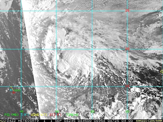
If they don't decide to upgrade this in the next 12hrs I'll be seriously shocked, I think we have our next tropical system right here.
Will it be a threat to the US, I'm not sure just yet but if it keeps its current heading then its a chance, the set-up that is steering Hanna will be similar for 97L as well should think.
Will it be a threat to the US, I'm not sure just yet but if it keeps its current heading then its a chance, the set-up that is steering Hanna will be similar for 97L as well should think.
0 likes


The bad news though Hurakan was Hanna was just as far north if not slightly more so where 97L is presently, then again 97L is going to form far sooner and faster then Hanna thus will have more time to latch onto deeper steering currents.
Should note the ECM doesn't look very pleasent to be honest...
Should note the ECM doesn't look very pleasent to be honest...
0 likes


ABNT20 KNHC 011149
TWOAT
TROPICAL WEATHER OUTLOOK
NWS TPC/NATIONAL HURRICANE CENTER MIAMI FL
800 AM EDT MON SEP 1 2008
FOR THE NORTH ATLANTIC...CARIBBEAN SEA AND THE GULF OF MEXICO...
THE NATIONAL HURRICANE CENTER IS ISSUING ADVISORIES ON HURRICANE
GUSTAV...LOCATED OVER THE GULF OF MEXICO ABOUT 150 MILES
SOUTHEAST OF LAFAYETTE LOUISIANA...AND ON TROPICAL STORM
HANNA...LOCATED ABOUT 90 MILES NORTH-NORTHEAST OF THE
SOUTHEASTERN BAHAMAS.
SATELLITE IMAGERY INDICATES THAT A TROPICAL DEPRESSION COULD BE
FORMING ABOUT HALFWAY BETWEEN AFRICA AND THE LESSER ANTILLES. IF
THIS TREND CONTINUES...ADVISORIES WILL BE INITIATED LATER TODAY.
THIS SYSTEM IS MOVING WESTWARD AT ABOUT 15 MPH.
A STRONG TROPICAL WAVE HAS EMERGED OFF THE WEST COAST OF AFRICA
AND IS SEVERAL HUNDRED MILES SOUTHEAST OF THE CAPE VERDE ISLANDS.
THIS SYSTEM IS SHOWING SIGNS OF ORGANIZATION...AND A TROPICAL
DEPRESSION COULD FORM DURING THE NEXT COUPLE OF DAYS AS IT MOVES
WESTWARD AT 15 TO 20 MPH.
AN AREA OF DISTURBED WEATHER LOCATED ABOUT 250 MILES EAST OF THE
LEEWARD ISLANDS IS PRODUCING DISORGANIZED SHOWERS AND THUNDERSTORMS.
ALTHOUGH SURFACE PRESSURES ARE LOW...UPPER-LEVEL WINDS ARE NOT
FAVORABLE FOR SIGNIFICANT DEVELOPMENT OF THIS SYSTEM AS MOVES
SLOWLY WESTWARD.
AN AREA OF DISTURBED WEATHER LOCATED ABOUT 700 MILES EAST-SOUTHEAST
OF BERMUDA IS PRODUCING A LARGE AREA OF CLOUDINESS AND
THUNDERSTORMS. DEVELOPMENT OF THIS SYSTEM...IF ANY...WILL BE SLOW
TO OCCUR AS IT MOVES TOWARD THE NORTHWEST AT 10 TO 15 MPH.
ELSEWHERE...TROPICAL CYCLONE FORMATION IS NOT EXPECTED DURING THE
NEXT 48 HOURS.
$$
FORECASTER RHOME/AVILA
0 likes
-
cycloneye
- Admin
- Posts: 149719
- Age: 69
- Joined: Thu Oct 10, 2002 10:54 am
- Location: San Juan, Puerto Rico
Re: Invest 97L in Eastern Atlantic=8 AM TWO=TD is Forming
Here we go at 11 AM with the first advisory unless something happens that it falls apart.
0 likes
Who is online
Users browsing this forum: No registered users and 66 guests