CAT 5 Hurricane Dean - Archived threads
Moderator: S2k Moderators
-
MGC

- S2K Supporter

- Posts: 5940
- Joined: Sun Mar 23, 2003 9:05 pm
- Location: Pass Christian MS, or what is left.
Re: Major Hurricane DEAN: (8 PM page 269) Discussions, Analysis
Looks like the eye is starting to contract as seen on the latest IR loop. Dean should pass well south of Grand Cayman. Very likely a Cat-5 in the W Carb Sea.....MGC
0 likes
-
Ivanhater

- Storm2k Moderator

- Posts: 11221
- Age: 39
- Joined: Fri Jul 01, 2005 8:25 am
- Location: Pensacola
Re:
Steve wrote:>>Could someone seriously find out if I need to start evac?
Yes. We're all going to die.
Please. You're either pulling everyone's leg or trolling the site. "Could someone seriously find out if I need to start evac"? Pay attention to your local news or weather agency. I mean, come on.

Steve
0 likes
-
CrazyC83
- Professional-Met

- Posts: 34315
- Joined: Tue Mar 07, 2006 11:57 pm
- Location: Deep South, for the first time!
284
URNT15 KNHC 200154
AF304 1104A DEAN HDOB 20 20070820
014430 1654N 07853W 6969 03073 9976 +080 +080 323046 047 040 006 00
014500 1652N 07855W 6965 03081 9981 +080 +080 325045 046 039 005 00
014530 1651N 07856W 6965 03086 9988 +079 +079 325045 045 037 006 00
014600 1650N 07857W 6972 03081 0003 +072 +072 325043 045 037 004 00
014630 1648N 07859W 6960 03100 9996 +080 +080 324040 041 035 005 00
014700 1647N 07900W 6967 03094 9994 +083 +083 323040 041 035 003 00
014730 1646N 07901W 6966 03097 9997 +083 +083 326042 042 033 003 00
014800 1644N 07903W 6969 03097 0001 +082 +082 329043 044 034 002 03
014830 1642N 07903W 6969 03101 0004 +085 +071 324044 044 999 999 03
014900 1642N 07901W 6962 03108 0003 +086 +066 316039 041 025 004 03
014930 1642N 07859W 6967 03103 0004 +084 +070 316039 040 034 003 03
015000 1642N 07857W 6964 03103 0001 +083 +071 310037 038 035 004 00
015030 1642N 07854W 6969 03092 9994 +086 +072 307037 037 036 003 00
015100 1642N 07852W 6965 03096 9994 +085 +078 306039 040 037 004 00
015130 1643N 07850W 6968 03090 9991 +085 +077 301041 041 039 004 00
015200 1643N 07848W 6967 03090 9992 +081 +081 296042 042 039 004 00
015230 1643N 07846W 6967 03086 9999 +073 +073 291040 042 040 006 00
015300 1643N 07844W 6965 03085 9978 +087 +086 286040 040 039 004 00
015330 1643N 07842W 6969 03079 9979 +085 +085 282040 040 040 004 00
015400 1644N 07839W 6966 03083 9982 +082 +082 281040 041 041 004 00
$$
0 likes
-
wxman57

- Moderator-Pro Met

- Posts: 23172
- Age: 68
- Joined: Sat Jun 21, 2003 8:06 pm
- Location: Houston, TX (southwest)
Re: Major Hurricane DEAN: (8 PM page 269) Discussions, Analysis
JessRomero wrote:One question can this storm still turn toward Texas??
Very, very slim chance (less than 5%). The ridge is building north of Dean again, as evident by the increased forward speed and near due-west motion in recent hours. Dean may not get north of 20N as strong as the high is. As for Dr. Frank, he's been trying to draw a hurricane here for over 20 years. Almost every storm out there "could come this way". Yeah, the chances aren't zero, but they're less than 1%.
Vortex message just reported 926mb. Eyewall should be contracting next 24 hours. If the ridge north of it doesn't move Dean along too fast, then Dean may drop to near 900mb and reach 170-180 mph before the Yucatan.
Time for bed.
0 likes
-
Sabanic

- Category 2

- Posts: 683
- Age: 66
- Joined: Wed Aug 01, 2007 7:01 am
- Location: Mobile, AL
- Contact:
Re: Hurricane DEAN: Global Models
Berwick Bay wrote:I'll repeat something I said earlier, and that is if there is a stall, and its a big IF, then it might be related to an elongating ULL. Something that I had postulated earlier this morning on another board. I've often seen ULL take WSW dips. I thought that this one might "feel" that area over the Bay of Campeche and "stretch" in that direction away from its basic west course (to WSW). This area in the Bay of Campeche is an area of stalled steering currents at this time of the year. If it stretches part of itself down here, then it might not want to move much. Also, by elongating (at least in the short term--couple of days) it might retain something of its circulation over the central Gulf. So you might have a SW to NE ULL axis over the central Gulf, which would induce Dean on a more Northerly route up the Yucatan and toward the central Gulf. Of course that has not happened. But if the ULL stalls I would look to see if it has also elongated and if this might not be part of the reason for the stall.
That is what I was thinking. IF it elongated and stalled or either slowed way down then it would possibly spin Dean northward, but I also thought that even if that did happen he would be at too low of a latitude for it to matter.
0 likes
-
cycloneye

- Admin

- Posts: 149317
- Age: 69
- Joined: Thu Oct 10, 2002 10:54 am
- Location: San Juan, Puerto Rico
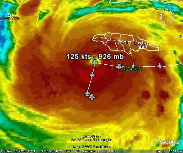
Re: Hurricane DEAN Recon obs
000
URNT12 KNHC 200150
VORTEX DATA MESSAGE AL042007
A. 20/01:31:00Z
B. 17 deg 28 min N
078 deg 18 min W
C. 700 mb 2466 m
D. 121 kt
E. 073 deg 16 nm
F. 160 deg 125 kt
G. 075 deg 021 nm
H. 926 mb
I. 7 C/ 3049 m
J. 16 C/ 3044 m
K. 16 C/ NA
L. CLOSED
M. C16
N. 12345/7
O. 0.02 / 2 nm
P. AF304 1104A DEAN OB 05
MAX FL WIND 125 KT E QUAD 01:25:00 Z
0 likes
-
storms in NC

- S2K Supporter
- Posts: 2338
- Joined: Thu Jul 28, 2005 2:58 pm
- Location: Wallace,NC 40 miles NE of Wilm
- Contact:
Re: Major Hurricane DEAN: (5 PM page 262) Discussions, Analysis
otowntiger wrote:Matt-hurricanewatcher wrote:Remember this has a outter eye wall that go's out like 20 miles from the center point(eye pressure min) making it 40 miles wide on last recon. So it is not out of the possible this sucker is going right over them or very close. A 145-150 mph hurricane can have gust to 170-180 mph.
Nope. Not in Kingston, not from this storm. No way. It's been weakening all day, and never got that close to shore. It is not nearly big enough or strong enough to produce those kinds of winds in Kingston that far away from the storm center. Jamaica got VERY lucky once again. Thank God.
How would you feel sitting there with your roof blown off your walls blown in the water. So you sitting there by a rock and pray that you don't get blown away or something fly and hits you in the head. This is how these people live there. They have shacks for homes. A piece of tin just laid over the top to keep the rain out. I know this For my daughter goes there once a year to help them out. No running water. Would you believe that a bag of rice is like gold to them. If they had just 80 mph winds would have been to much. I hope that if your city sends food to these people you will do your part.
Okay off my box.
Now how do you fix crow. I have never had to cook it and eat it before. I was very wrong. I thought it would hit the Island.
Deb
0 likes
-
setxweathergal

- Tropical Low

- Posts: 39
- Joined: Sun Nov 05, 2006 2:50 pm
- Location: Beaumont/Lumberton
Re: Re:
Ivanhater wrote:Steve wrote:>>Could someone seriously find out if I need to start evac?
Yes. We're all going to die.
Please. You're either pulling everyone's leg or trolling the site. "Could someone seriously find out if I need to start evac"? Pay attention to your local news or weather agency. I mean, come on.
Steve
Nothing funny about that, in my opinion!
Last edited by setxweathergal on Sun Aug 19, 2007 8:59 pm, edited 1 time in total.
0 likes
-
Texashawk

- Category 2
- Posts: 579
- Joined: Tue Aug 14, 2007 1:50 am
- Location: Missouri City, TX (Houston)
Re:
Or, they could be geniunely concerned that they'd be caught with their pants down, so to speak, and have to go though an even more accelerated Rita evac. And unless you're from Houston/SE Texas, you can't understand what hell that was. I don't think they were trolling. I know the hell that they want to avoid. Bit of panic? Sure. Troll? Virtually certain to be never.
Steve wrote:>>Could someone seriously find out if I need to start evac?
Yes. We're all going to die.
Please. You're either pulling everyone's leg or trolling the site. "Could someone seriously find out if I need to start evac"? Pay attention to your local news or weather agency. I mean, come on.
Steve
0 likes
-
Portastorm

- Storm2k Moderator
- Posts: 9955
- Age: 63
- Joined: Fri Jul 11, 2003 9:16 am
- Location: Round Rock, TX
- Contact:
Re: Hurricane DEAN: Global Models
The 0z NAM is starting to run ... it'll be interesting to see how it treats the ULL as well as Dean. Not that I trust this model at all ... only curious as its the first 0z model out for consumption and I'm kinda curious what it does with this low, if anything at all.
0 likes
-
dwsqos2
Re: Hurricane DEAN Recon obs
Eyewall Drop...
000
UZNT13 KNHC 200154
XXAA 70017 99175 70781 04478 99945 26205 11117 00/// ///// /////
92191 24604 11618 85934 22425 13622 70609 13800 15619 88999 77999
31313 09608 80127
61616 AF304 1104A DEAN OB 07
62626 EYEWALL 090 SPL 1761N07820W 0131 MBL WND 12121 AEV 00000 DL
M WND 14119 944708 WL150 11623 082 =
XXBB 70018 99175 70781 04478 00945 26205 11850 22425 22778 20045
33725 16236 44707 15407 55697 13000
21212 00945 11117 11937 11126 22924 11617 33917 12124 44907 12620
55885 13127 66850 13622 77697 15618
31313 09608 80127
61616 AF304 1104A DEAN OB 07
62626 EYEWALL 090 SPL 1761N07820W 0131 MBL WND 12121 AEV 00000 DL
M WND 14119 944708 WL150 11623 082 =
945 mb; surface winds of 117 knots; MBL winds of 121 knots. (Unless terribly mistaken, splash point was in the northeastern (more eastern than northern) eyewall.)
Eye Drop...
000
UZNT13 KNHC 200155
XXAA 70027 99175 70783 04478 99926 27001 15018 00/// ///// /////
92014 26801 15017 85764 23401 19019 70450 16200 23507 88999 77999
31313 09608 80131
61616 AF304 1104A DEAN OB 08
62626 EYE SPL 1747N07831W 0134 MBL WND 16520 AEV 00000 DLM WND 19
015 926719 WL150 15518 075 =
XXBB 70028 99175 70783 04478 00926 27001 11850 23401 22723 17812
33705 17200 44697 15400
21212 00926 15018 11900 17018 22888 17023 33850 19019 44794 21514
55738 21511 66697 24007
31313 09608 80131
61616 AF304 1104A DEAN OB 08
62626 EYE SPL 1747N07831W 0134 MBL WND 16520 AEV 00000 DLM WND 19
015 926719 WL150 15518 075 =
926 mb; surface winds of 18 knots; MBL winds of 20 knots.
000
UZNT13 KNHC 200154
XXAA 70017 99175 70781 04478 99945 26205 11117 00/// ///// /////
92191 24604 11618 85934 22425 13622 70609 13800 15619 88999 77999
31313 09608 80127
61616 AF304 1104A DEAN OB 07
62626 EYEWALL 090 SPL 1761N07820W 0131 MBL WND 12121 AEV 00000 DL
M WND 14119 944708 WL150 11623 082 =
XXBB 70018 99175 70781 04478 00945 26205 11850 22425 22778 20045
33725 16236 44707 15407 55697 13000
21212 00945 11117 11937 11126 22924 11617 33917 12124 44907 12620
55885 13127 66850 13622 77697 15618
31313 09608 80127
61616 AF304 1104A DEAN OB 07
62626 EYEWALL 090 SPL 1761N07820W 0131 MBL WND 12121 AEV 00000 DL
M WND 14119 944708 WL150 11623 082 =
945 mb; surface winds of 117 knots; MBL winds of 121 knots. (Unless terribly mistaken, splash point was in the northeastern (more eastern than northern) eyewall.)
Eye Drop...
000
UZNT13 KNHC 200155
XXAA 70027 99175 70783 04478 99926 27001 15018 00/// ///// /////
92014 26801 15017 85764 23401 19019 70450 16200 23507 88999 77999
31313 09608 80131
61616 AF304 1104A DEAN OB 08
62626 EYE SPL 1747N07831W 0134 MBL WND 16520 AEV 00000 DLM WND 19
015 926719 WL150 15518 075 =
XXBB 70028 99175 70783 04478 00926 27001 11850 23401 22723 17812
33705 17200 44697 15400
21212 00926 15018 11900 17018 22888 17023 33850 19019 44794 21514
55738 21511 66697 24007
31313 09608 80131
61616 AF304 1104A DEAN OB 08
62626 EYE SPL 1747N07831W 0134 MBL WND 16520 AEV 00000 DLM WND 19
015 926719 WL150 15518 075 =
926 mb; surface winds of 18 knots; MBL winds of 20 knots.
Last edited by dwsqos2 on Sun Aug 19, 2007 9:12 pm, edited 1 time in total.
0 likes
Re: Major Hurricane DEAN: (8 PM page 269) Discussions, Analysis
Yeah, 926. Dean was obviously intensifying as he passed Jamaica. Not a bombing drop but a warm-top contraction looked just about right - not to mention an arcking wobble towards the island as it passed.
0 likes

Re: Major Hurricane DEAN: (8 PM page 269) Discussions, Analysis
clfenwi wrote:Dean's northern eyewall punishing Jamaica
8:21 p.m. ET 8/19/07
Tim Ballisty and M. Ressler, Meteorologists,The Weather Channel
The center of powerful Hurricane Dean is now passing just south of the western part of Jamaica with 145 mph winds; a healthy category 4 on the Saffir-Simpson scale.
A Kingston observing site has reported sustained easterly winds to 114 mph and gusts to at least 138 mph...
http://www.weather.com/newscenter/tropi ... enter_news
Their source for this is apparently the METAR ob that was posted earlier and repeated here for those who missed it:
MKJP 192200Z COR 10099OO120KT 0KM BKN010 BKN012CB OVC080 XX/XX Q0994=
Notice the 114mph reading bottom right corner of graph.
Last edited by TampaFl on Sun Aug 19, 2007 9:04 pm, edited 1 time in total.
0 likes


Re: Major Hurricane DEAN: (5 PM page 262) Discussions, Analysis
storms in NC wrote:Now how do you fix crow. I have never had to cook it and eat it before. I was very wrong. I thought it would hit the Island.
Deb
Pluck feathers, behead said crow. Roast at 400 degrees until internal temp is 165. Gag, eat and grin... we all make mistakes...
0 likes
-
fasterdisaster
- Category 5

- Posts: 1868
- Joined: Mon Sep 19, 2005 4:41 pm
- Location: Miami, Florida
Re: Major Hurricane DEAN: (8 PM page 269) Discussions, Analysis
TampaFl wrote:clfenwi wrote:Dean's northern eyewall punishing Jamaica
8:21 p.m. ET 8/19/07
Tim Ballisty and M. Ressler, Meteorologists,The Weather Channel
The center of powerful Hurricane Dean is now passing just south of the western part of Jamaica with 145 mph winds; a healthy category 4 on the Saffir-Simpson scale.
A Kingston observing site has reported sustained easterly winds to 114 mph and gusts to at least 138 mph...
http://www.weather.com/newscenter/tropi ... enter_news
Their source for this is apparently the METAR ob that was posted earlier and repeated here for those who missed it:
MKJP 192200Z COR 10099OO120KT 0KM BKN010 BKN012CB OVC080 XX/XX Q0994=
LOL you think wunderground can handle more than 52 mph winds? CLEARLY their station was damaged.
0 likes
-
Ivanhater
- Storm2k Moderator
- Posts: 11221
- Age: 39
- Joined: Fri Jul 01, 2005 8:25 am
- Location: Pensacola
Re: Re:
setxweathergal wrote:Ivanhater wrote:Steve wrote:>>Could someone seriously find out if I need to start evac?
Yes. We're all going to die.
Please. You're either pulling everyone's leg or trolling the site. "Could someone seriously find out if I need to start evac"? Pay attention to your local news or weather agency. I mean, come on.
Steve
Nothing funny about that, in my opinion!
I'm sorry you didnt think so
Last edited by Ivanhater on Sun Aug 19, 2007 9:05 pm, edited 1 time in total.
0 likes
-
CrazyC83
- Professional-Met
- Posts: 34315
- Joined: Tue Mar 07, 2006 11:57 pm
- Location: Deep South, for the first time!
816
URNT15 KNHC 200204
AF304 1104A DEAN HDOB 21 20070820
015430 1644N 07837W 6968 03078 9979 +082 +082 276041 042 041 003 00
015500 1644N 07835W 6967 03079 9972 +086 +086 271042 042 041 003 00
015530 1644N 07833W 6965 03079 9970 +088 +086 269042 042 042 003 00
015600 1645N 07831W 6967 03077 9968 +089 +074 267044 044 043 003 00
015630 1645N 07828W 6967 03077 9964 +092 +071 265045 045 043 003 00
015700 1645N 07826W 6967 03074 9968 +089 +074 262045 046 043 004 00
015730 1645N 07824W 6966 03077 9969 +086 +086 257047 048 044 005 00
015800 1645N 07822W 6966 03077 9972 +085 +085 251047 047 044 004 00
015830 1646N 07819W 6968 03075 9976 +081 +081 248047 047 043 005 00
015900 1646N 07817W 6965 03080 9978 +080 +080 239048 049 042 005 00
015930 1646N 07815W 6966 03079 9983 +078 +078 239049 050 043 004 00
020000 1646N 07813W 6966 03084 9980 +082 +082 236051 051 043 004 00
020030 1646N 07810W 6965 03083 9981 +082 +082 231051 051 041 005 00
020100 1647N 07808W 6967 03084 9989 +077 +077 228051 052 040 004 00
020130 1647N 07806W 6968 03085 9996 +076 +076 222050 051 041 004 00
020200 1647N 07804W 6967 03088 9996 +076 +076 217049 050 041 004 00
020230 1647N 07802W 6965 03091 9996 +078 +076 219051 052 041 003 00
020300 1647N 07800W 6968 03091 9995 +080 +072 219052 053 041 003 00
020330 1648N 07757W 6965 03096 9993 +085 +070 219053 053 038 004 00
020400 1648N 07755W 6960 03105 0001 +081 +066 215053 053 999 999 03
$$
0 likes
Re: Hurricane DEAN: Global Models
Of some interest in all this is the fact that Deans forward speed has also picked up a bit today
0 likes

-
Stratosphere747
- Category 5
- Posts: 3772
- Joined: Thu Sep 11, 2003 8:34 pm
- Location: Surfside Beach/Freeport Tx
- Contact:
Re: Hurricane DEAN: Global Models
Lets clarify the ULL issue as well - It has not stalled. Moving a bit slower, but not stalled.
If there was an indication of a possible stall, you can bet that it would be addressed in the next disco.
If there was an indication of a possible stall, you can bet that it would be addressed in the next disco.
0 likes
Who is online
Users browsing this forum: No registered users and 94 guests