Tropical Depression GABRIELLE:Discussions and Images

Moderator: S2k Moderators

Message
Author
User avatar
Bane
Category 2
Category 2
Posts: 690
Joined: Wed Sep 17, 2003 3:06 pm
Location: Ogden, NC
Contact:

Re:

#321 Postby Bane » Sat Sep 08, 2007 5:40 pm

storms in NC wrote:Okay I have had it with this dry weather. A white oak just went over my bear foot. I about craped. They are bad snakes. They are small. Dear Lord PLEASE give Us rain.tonight and Sunday No more snakes. This make 3 in 24 hours. they looking for water.


a what?
0 likes   

User avatar
HURAKAN
Professional-Met
Professional-Met
Posts: 46086
Age: 38
Joined: Thu May 20, 2004 4:34 pm
Location: Key West, FL
Contact:

#322 Postby HURAKAN » Sat Sep 08, 2007 5:41 pm

Latest:

Image
0 likes   

Sanibel
Category 5
Category 5
Posts: 10375
Joined: Mon Aug 30, 2004 11:06 pm
Location: Offshore SW Florida

Re: Tropical Storm GABRIELLE (ATL): Discussions and Images

#323 Postby Sanibel » Sat Sep 08, 2007 5:51 pm

See if we can get a Gulf Stream reaction now that it is better stacked.

A "white oak"???
0 likes   

User avatar
curtinnc
Tropical Depression
Tropical Depression
Posts: 79
Joined: Fri Jul 15, 2005 4:32 pm
Location: Cornelius, NC
Contact:

Re: Tropical Storm GABRIELLE (ATL): Discussions and Images

#324 Postby curtinnc » Sat Sep 08, 2007 5:53 pm

txwatcher91 wrote:
calamity wrote:For the first time in here life, she looks tropical.

Image


WOW, that is a very nice animation showing the LLC shoot under the convection. It appears that it is over or near the gulf stream. I wonder how much it might strengthen tonight...


Darn right! This is quite a view! You know what, I never thought I'd say this... But I just love floaters! Hahahaaa, that just doesn't sound right does it?? Say it a few times out loud, you'll be laughin' too!
0 likes   

User avatar
brunota2003
S2K Supporter
S2K Supporter
Posts: 9476
Age: 34
Joined: Sat Jul 30, 2005 9:56 pm
Location: Stanton, KY...formerly Havelock, NC
Contact:

#325 Postby brunota2003 » Sat Sep 08, 2007 6:04 pm

Alright, looking at the Infrared, one can instantly pick up two things. One is that the convection is clearly getting deeper and the second is that it is expanding, leading me to believe more of NC will see rain (yeah, yeah, I know I'm -removed- :lol:). Also on visible, the secondary center has shot up into the convection (as seen by the loop earlier) and I have not seen a hide nor hair of it since. The convection appears to be trying to build back down over the main center of circulation, and does appear to be covering a good 1/2 of it as I type. Now, who wants to take a guess at what D Max will do to the storm?
0 likes   

User avatar
BigA
Professional-Met
Professional-Met
Posts: 1317
Joined: Sun Jul 24, 2005 10:56 pm

#326 Postby BigA » Sat Sep 08, 2007 6:10 pm

Wind shear looks pretty low in the area which it will be passing through tonight and tomorrow morning, http://cimss.ssec.wisc.edu/tropic/real- ... g8shr.html and it will be passing over the Gulf Stream, so I could definitely see some moderate intensification (especially since the storm's convection is increasing as we approach DMIN, even though I am the first to admit, that I dont really understand DMAX and DMIN). I wouldnt think it would be stronger than a moderate tropical storm, but in this case, I think we can hope that it intensifies a little bit, as that would mean a larger rain shield, and more drought relief for extreme eastern NC.
0 likes   

txwatcher91
Category 5
Category 5
Posts: 1498
Joined: Tue Aug 02, 2005 2:29 pm

Re:

#327 Postby txwatcher91 » Sat Sep 08, 2007 6:12 pm

brunota2003 wrote:. Now, who wants to take a guess at what D Max will do to the storm?


Make it intensify :D

BigA, as I understand it, the difference is in the atmosphere. In DMIN, the difference between the water and the air above is less because the sun heats the air, making a smaller temperature difference. In DMAX, the ocean temp stays about the same, but the air above it cools, making a larger difference in temp, resulting in more vigorous and intense storms, and a better chance of intensification.
Last edited by txwatcher91 on Sat Sep 08, 2007 6:15 pm, edited 1 time in total.
0 likes   

cpdaman
Category 5
Category 5
Posts: 3131
Joined: Sat Jun 10, 2006 11:44 am
Location: SPB county (gulf stream)

Re: Tropical Storm GABRIELLE (ATL): Discussions and Images

#328 Postby cpdaman » Sat Sep 08, 2007 6:14 pm

hey pro-mets some N.C people maybe growing a little anxious looking at the satelite's (especially those on the outer banks)

any new forecasts

the storm has what another 10 hours over gulf stream

my impression has gone from a strong breeze (30) mph on the outer banks to paranoid brainstorming of (rapid intensification)

the result will probably be closer to the former but what do the pro's think now.
0 likes   

User avatar
windstorm99
S2K Supporter
S2K Supporter
Posts: 1578
Age: 47
Joined: Sat May 26, 2007 8:10 am
Location: Miami, Florida
Contact:

Re: Tropical Storm GABRIELLE (ATL): Discussions and Images

#329 Postby windstorm99 » Sat Sep 08, 2007 6:21 pm

What are you guys talking about the NHC does not even take this systems past 45kts on its closest approach to the carolina coast.The window here is small for any really significant development to take place.
0 likes   

User avatar
Wthrman13
Professional-Met
Professional-Met
Posts: 502
Joined: Sun Jul 06, 2003 12:44 pm
Location: West Lafayette, IN
Contact:

#330 Postby Wthrman13 » Sat Sep 08, 2007 6:23 pm

Well, it definitely looks like the storm is intensifying based on radar and satellite. There is some pretty deep convection firing right over the center, and some lightning even showing up on the NLDN right near the center. It really depends on how well the LLC and MLC can remain coupled over the next several hours. There may be just enough window of opportunity to allow the storm to get up to near hurricane strength if the current trend continues. On the other hand, none of the intensity guidance (including the GFDL and HWRF) supports this at this point.
0 likes   

User avatar
brunota2003
S2K Supporter
S2K Supporter
Posts: 9476
Age: 34
Joined: Sat Jul 30, 2005 9:56 pm
Location: Stanton, KY...formerly Havelock, NC
Contact:

Re: Tropical Storm GABRIELLE (ATL): Discussions and Images

#331 Postby brunota2003 » Sat Sep 08, 2007 6:24 pm

cpdaman wrote:my impression has gone from a strong breeze (30) mph on the outer banks to paranoid brainstorming of (rapid intensification)

I highly doubt we are paranoidly considering rapid instensification, however, we are watching this system closely and when I post stuff on what I see and think it could do, it is all based off of my experiences with systems off the coast/over the gulf stream. I am not thinking RI, however, I can see this making a run for Hurricane strength tonight if it continues to rapidly get its act together. 990 millibars is sounding pretty good right about now. If the wind shear kicks in or the thunderstorms fall apart over the next couple hours, then it might only hit 50 mph, but stranger things have happened over the Gulf Stream than a system intensifing pretty good overnight.
0 likes   

hurricanewatcher

#332 Postby hurricanewatcher » Sat Sep 08, 2007 6:25 pm

go gabby go ... not going to be bad in eastern nc, but alittle excitement never hurt anyone :D :D :D :D :D :D :D :D :cheesy: :cheesy: :cheesy: :cheesy: :ggreen: :ggreen:
0 likes   

User avatar
brunota2003
S2K Supporter
S2K Supporter
Posts: 9476
Age: 34
Joined: Sat Jul 30, 2005 9:56 pm
Location: Stanton, KY...formerly Havelock, NC
Contact:

Re: Tropical Storm GABRIELLE (ATL): Discussions and Images

#333 Postby brunota2003 » Sat Sep 08, 2007 6:26 pm

windstorm99 wrote:What are you guys talking about the NHC does not even take this systems past 45kts on its closest approach to the carolina coast.The window here is small for any really significant development to take place.

Right now, it is not really a matter of how short the window is, it is a matter of the fact it is organizing at a good clip AND is either over or getting ready to pass over the Gulf Stream. Just think of the Gulf Stream as the Loop Current of the Western Atlantic.
0 likes   

philnyc
S2K Supporter
S2K Supporter
Posts: 313
Joined: Thu Jun 07, 2007 1:14 am
Location: Brooklyn, New York City, New York
Contact:

Re: Tropical Storm GABRIELLE (ATL): Discussions and Images

#334 Postby philnyc » Sat Sep 08, 2007 6:29 pm

brunota2003 wrote:
windstorm99 wrote:What are you guys talking about the NHC does not even take this systems past 45kts on its closest approach to the carolina coast.The window here is small for any really significant development to take place.

Right now, it is not really a matter of how short the window is, it is a matter of the fact it is organizing at a good clip AND is either over or getting ready to pass over the Gulf Stream. Just think of the Gulf Stream as the Loop Current of the Western Atlantic.


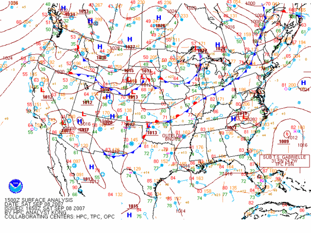
Does anyone see evidence of a stall-out? I'm beginning to wonder if that horse-shoe ridge to the west north and east might block this for a while:
Image
All summer the progs have underestimated that ridging that keeps building in over the northeast - some of you have mentioned it. (Remember this is a shallow storm.) Look at the NW ATL water vapor loop:

http://www.ssd.noaa.gov/goes/east/nwatl/loop-wv.html


No wonder it has slowed down. Since I can't see it going due east at Hatteras, it may have to slow down even more here. Of course, stalling over the Gulf Stream would be an interesting scenario, to say the least. Also, if it were to jog eastward, that could force it into a loop.
Thoughts?


P.S. Remember that the cold front in the northeast is forecast to become stationary and die out because of the Atlantic ridge.
Last edited by philnyc on Sat Sep 08, 2007 6:33 pm, edited 2 times in total.
0 likes   

User avatar
windstorm99
S2K Supporter
S2K Supporter
Posts: 1578
Age: 47
Joined: Sat May 26, 2007 8:10 am
Location: Miami, Florida
Contact:

Re: Tropical Storm GABRIELLE (ATL): Discussions and Images

#335 Postby windstorm99 » Sat Sep 08, 2007 6:31 pm

brunota2003 wrote:
windstorm99 wrote:What are you guys talking about the NHC does not even take this systems past 45kts on its closest approach to the carolina coast.The window here is small for any really significant development to take place.

Right now, it is not really a matter of how short the window is, it is a matter of the fact it is organizing at a good clip AND is either over or getting ready to pass over the Gulf Stream. Just think of the Gulf Stream as the Loop Current of the Western Atlantic.


I understand but as it was noted by the promet there is no intensity guidence that supports any real organzation with this system.My best guess 50-60mph at best.
0 likes   

User avatar
ronjon
Category 5
Category 5
Posts: 4822
Joined: Fri Aug 19, 2005 5:17 pm
Location: Hernando Beach, FL

Re: Tropical Storm GABRIELLE (ATL): Discussions and Images

#336 Postby ronjon » Sat Sep 08, 2007 6:32 pm

The color infared and radar signature indicates a deepening storm. Just how much can it intensify in 12 hrs? Consider now that atmospheric conditions (low shear) are the best in this storms history. Add the gulf stream and could we see a CAT 1 prior to LF? If it continues to strengthen the NHC may have to issue a hurricane warning after the next recon.
0 likes   

User avatar
deltadog03
Professional-Met
Professional-Met
Posts: 3580
Joined: Tue Jul 05, 2005 6:16 pm
Location: Macon, GA

#337 Postby deltadog03 » Sat Sep 08, 2007 6:36 pm

I still feel we will have a 80mph cane at landfall. That LLC got sucked in REALLY quick.
0 likes   

cpdaman
Category 5
Category 5
Posts: 3131
Joined: Sat Jun 10, 2006 11:44 am
Location: SPB county (gulf stream)

Re: Tropical Storm GABRIELLE (ATL): Discussions and Images

#338 Postby cpdaman » Sat Sep 08, 2007 6:40 pm

model intensity forecasts are unreliable in general, never mind when a system out of the blue decides to try and gets it's act together

just thinking worst case
0 likes   

User avatar
storms in NC
S2K Supporter
S2K Supporter
Posts: 2338
Joined: Thu Jul 28, 2005 2:58 pm
Location: Wallace,NC 40 miles NE of Wilm
Contact:

#339 Postby storms in NC » Sat Sep 08, 2007 6:41 pm

A white oak is a Copperhead I think.
All I know is what they call them around here.

Well we might get a little rain from what the news said
0 likes   

philnyc
S2K Supporter
S2K Supporter
Posts: 313
Joined: Thu Jun 07, 2007 1:14 am
Location: Brooklyn, New York City, New York
Contact:

#340 Postby philnyc » Sat Sep 08, 2007 6:46 pm

I really think it's stalling out.
0 likes   


Return to “2007”

Who is online

Users browsing this forum: No registered users and 15 guests