BoB: Very Severe Cyclonic Storm SIDR

Moderator: S2k Moderators

Message
Author
Coredesat

#181 Postby Coredesat » Tue Nov 13, 2007 10:03 am

Image
Image
0 likes   

Sanibel
Category 5
Category 5
Posts: 10375
Joined: Mon Aug 30, 2004 11:06 pm
Location: Offshore SW Florida

Re: NIO: Bay of Bengal: : Tropical Cyclone SIDR 0709

#182 Postby Sanibel » Tue Nov 13, 2007 10:08 am

It doesn't look like a system that will retain power all the way to land. The hazy look to the Tibetan Plateau in that satellite shot is cold conditions.
0 likes   

Derek Ortt

#183 Postby Derek Ortt » Tue Nov 13, 2007 10:15 am

It is likely going through an EWRC. This was as clear as crystal yesterday when the secondary band set up. This does not constitute a long term weakening trend
0 likes   

hcane27
Tropical Storm
Tropical Storm
Posts: 231
Joined: Tue Jan 31, 2006 7:33 pm

Re: 06B - Sidr models thread

#184 Postby hcane27 » Tue Nov 13, 2007 10:17 am

Image
spelling correction .....
0 likes   

User avatar
HURAKAN
Professional-Met
Professional-Met
Posts: 46086
Age: 38
Joined: Thu May 20, 2004 4:34 pm
Location: Key West, FL
Contact:

#185 Postby HURAKAN » Tue Nov 13, 2007 10:37 am

Image

If this map is correct, very strong windshear just north of the storm.
0 likes   

Derek Ortt

#186 Postby Derek Ortt » Tue Nov 13, 2007 10:38 am

much of that shear is the storm's outflow

I don't expect to see much more weakening based upon the satellite imagery

http://www.nrlmry.navy.mil/tropics-bin/ ... &SIZE=Full
0 likes   

User avatar
Chacor
Category 5
Category 5
Posts: 10229
Joined: Mon Oct 02, 2006 10:43 pm
Location: Singapore

#187 Postby Chacor » Tue Nov 13, 2007 11:09 am

Love the new Google Earth cloud cover courtesy NRL. Image is from 1400z.

Eye seems to have disappeared again.

Image
0 likes   

User avatar
WindRunner
Category 5
Category 5
Posts: 5806
Age: 34
Joined: Fri Jul 29, 2005 8:07 pm
Location: Warrenton, VA, but Albany, NY for school
Contact:

#188 Postby WindRunner » Tue Nov 13, 2007 11:10 am

Yeah, it's the outflow of the storm that's also getting pulled into an exiting jet streak. There's also another jet streak dropping in from currently around Pakistan, but shouldn't quite affect the storm prior to landfall. If it can speed up, that may be the only saving grace to those on the coast.
0 likes   

CrazyC83
Professional-Met
Professional-Met
Posts: 34002
Joined: Tue Mar 07, 2006 11:57 pm
Location: Deep South, for the first time!

#189 Postby CrazyC83 » Tue Nov 13, 2007 11:28 am

The storm seems to have grown significantly as well...
0 likes   

CrazyC83
Professional-Met
Professional-Met
Posts: 34002
Joined: Tue Mar 07, 2006 11:57 pm
Location: Deep South, for the first time!

#190 Postby CrazyC83 » Tue Nov 13, 2007 11:31 am

UW - CIMSS
ADVANCED DVORAK TECHNIQUE
ADT-Version 7.2.1
Tropical Cyclone Intensity Algorithm

----- Current Analysis -----
Date : 13 NOV 2007 Time : 140000 UTC
Lat : 13:20:20 N Lon : 89:46:44 E

CI# /Pressure/ Vmax
6.2 / 921.8mb/119.8kt

6hr-Avg T# 3hr-Avg T# Adj T# Raw T#
6.2 6.2 6.7 6.7

Latitude bias adjustment to MSLP : +0.0mb

Estimated radius of max. wind based on IR :<10 km

Center Temp : -37.9C Cloud Region Temp : -79.4C

Scene Type : PINHOLE EYE

Positioning Method : SPIRAL ANALYSIS

Ocean Basin : INDIAN
Dvorak CI > MSLP Conversion Used : PACIFIC

Tno/CI Rules : Constraint Limits : NO LIMIT
Weakening Flag : OFF
Rapid Dissipation Flag : OFF

****************************************************

Trend is towards intensification once again. I'd be worried about this potentially bombing out into a monster...
0 likes   

Derek Ortt

#191 Postby Derek Ortt » Tue Nov 13, 2007 11:33 am

This is like a feeling of helplessness. We know what is going to happen, yet there is not much we can do about it
0 likes   

Derek Ortt

#192 Postby Derek Ortt » Tue Nov 13, 2007 11:35 am

http://www.nrlmry.navy.mil/tropics-bin/ ... &SIZE=Full

more symmetrical and the eye remains well-defined
0 likes   

CrazyC83
Professional-Met
Professional-Met
Posts: 34002
Joined: Tue Mar 07, 2006 11:57 pm
Location: Deep South, for the first time!

Re:

#193 Postby CrazyC83 » Tue Nov 13, 2007 11:36 am

Derek Ortt wrote:This is like a feeling of helplessness. We know what is going to happen, yet there is not much we can do about it


I know, this feels like the times when Katrina and Rita were getting ready to ramp up. A Cat 5 storm seems quite possible now...
0 likes   

User avatar
Chacor
Category 5
Category 5
Posts: 10229
Joined: Mon Oct 02, 2006 10:43 pm
Location: Singapore

#194 Postby Chacor » Tue Nov 13, 2007 11:38 am

Can we please avoid the "OMG this is gonna blow", especially since models - and JTWC - are really going for weakening past 48 hours?
0 likes   

User avatar
cycloneye
Admin
Admin
Posts: 145282
Age: 68
Joined: Thu Oct 10, 2002 10:54 am
Location: San Juan, Puerto Rico

Re: NIO: Bay of Bengal: : Tropical Cyclone SIDR 0709

#195 Postby cycloneye » Tue Nov 13, 2007 11:40 am

13/1400 UTC 13.3N 89.7E T5.5/6.0 SID -- Bay of Bengal


Not much stronger than the past data from SSD.
0 likes   

Sanibel
Category 5
Category 5
Posts: 10375
Joined: Mon Aug 30, 2004 11:06 pm
Location: Offshore SW Florida

Re: NIO: Bay of Bengal: : Tropical Cyclone SIDR 0709

#196 Postby Sanibel » Tue Nov 13, 2007 11:42 am

Shear charts show it moving towards shear.

Temperatures are relatively cool over India to its west. (high 70's)
0 likes   

Derek Ortt

#197 Postby Derek Ortt » Tue Nov 13, 2007 11:43 am

The weakening may be overdone quite a bit, though Chacor. The models have very strange evolutions of the storm. Isobars seem to disappear in a strange fashion (pressure goes up from 1003 to 1007mb, which is already underdone, but that is besides the point)

In addition, unlike the Atlantic, there are no synoptic surveillance flights; thus, we do not have a good handle on the storm initialization in the models or the upper air pattern. This kind of looks closer to Wilma when it was approaching South Florida, models and all forecasts went to weakening to a low end cat 2, yet it nearly became a cat 4 since the models had the shear in the wrong location

As for the SSD estimate, it is one of many. The ADT, which is more applicable since we have a well-defined eye, shows intensification
Last edited by Derek Ortt on Tue Nov 13, 2007 11:46 am, edited 1 time in total.
0 likes   

User avatar
Chacor
Category 5
Category 5
Posts: 10229
Joined: Mon Oct 02, 2006 10:43 pm
Location: Singapore

Re:

#198 Postby Chacor » Tue Nov 13, 2007 11:45 am

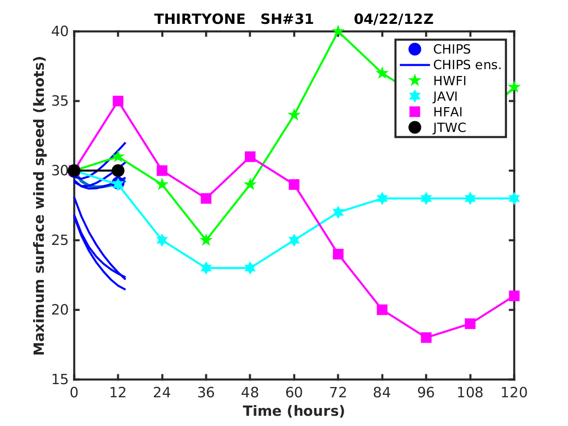
Derek Ortt wrote:The weakening may be overdone quite a bit, though Chacor.


Even then, it's not exactly an "it's gonna blow!" situation. The IMD have also trended their forecast down now (06z 14 Nov forecast was 125 kt, 12z 14 Nov forecast is 115 kt), FWIW.
0 likes   

Derek Ortt

#199 Postby Derek Ortt » Tue Nov 13, 2007 11:48 am

even if this weakens to 85-100KT (which may be the final landfall intensity), that would still devastate Bangladesh. remember, the 1970 cyclone was the equivalent of a marginal 3 (and Texas and western Louisiana know how bad a marginal 3 is... just look back at Rita)
0 likes   

Coredesat

Re: NIO: Bay of Bengal: : Tropical Cyclone SIDR 0709

#200 Postby Coredesat » Tue Nov 13, 2007 12:11 pm

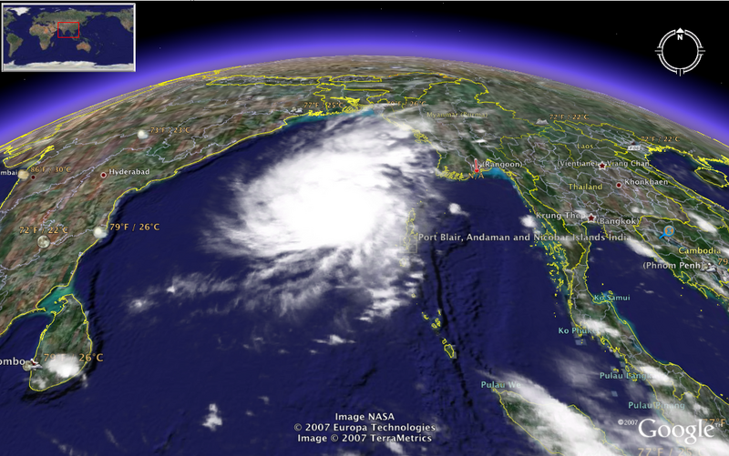
Sanibel wrote:It doesn't look like a system that will retain power all the way to land. The hazy look to the Tibetan Plateau in that satellite shot is cold conditions.


Well, the Tibetan Plateau is also an area of high elevations, although stable air from up there may influence Sidr as it approaches the coast.
0 likes   


Return to “2007”

Who is online

Users browsing this forum: No registered users and 1 guest